Linkinhorne on:
[Wikipedia]
[Google]
[Amazon]


 Linkinhorne (in Cornish ''Lanngynhorn'') is a

Linkinhorne Parish website
{{authority control Civil parishes in Cornwall Holy wells in Cornwall Villages in Cornwall


 Linkinhorne (in Cornish ''Lanngynhorn'') is a
 civil parish
In England, a civil parish is a type of administrative parish used for local government. It is a territorial designation which is the lowest tier of local government below districts and counties, or their combined form, the unitary authorit ...
and village in southeast Cornwall
Cornwall (; kw, Kernow ) is a Historic counties of England, historic county and Ceremonial counties of England, ceremonial county in South West England. It is recognised as one of the Celtic nations, and is the homeland of the Cornish people ...
, England, United Kingdom. The village itself is situated at and is approximately four miles (6.5 km) northwest of Callington
Callington ( kw, Kelliwik) is a civil parish and town in east Cornwall, England, United Kingdom about north of Saltash and south of Launceston.
Callington parish had a population of 4,783 in 2001, according to the 2001 census. This had ...
and seven miles (11 km) south of Launceston.Ordnance Survey: Landranger map sheet 201 ''Plymouth & Launceston'' The parish population at the 2011 census including Downgate was 1,541
Geography
As well as Linkinhorne village, other settlements in the parish include (in alphabetical order)Bray Shop
Bray Shop ( kw, Shoppa Bre) is a village in east Cornwall, England, United Kingdom, in the civil parish of Linkinhorne, Stoke Climsland and South Hill. It is located on the B3257 approximately three miles north-northwest of Callington.Ordnan ...
, Caradon Town, Downgate, Henwood, Ley Mill, Minions, Plushabridge
Plushabridge is a hamlet in the parish of Linkinhorne
Linkinhorne (in Cornish ''Lanngynhorn'') is a civil parish and village in southeast Cornwall, England, United Kingdom. The village itself is situated at and is approximately four mile ...
, Rilla Mill
Rilla Mill ( kw, Melin Reslegh) is a village in Cornwall, England. It is about one and half miles west of Linkinhorne
Linkinhorne (in Cornish ''Lanngynhorn'') is a civil parish and village in southeast Cornwall, England, United Kingdom. ...
and Upton Cross
Upton Cross and Upton are hamlets a quarter of a mile apart in east Cornwall, England, United Kingdom. Upton is situated at north of Upton Cross 5 miles (8 kilometres) northwest of Callington. They are on the northeast side of Caradon Hill on th ...
. The area is bordered by the River Inny in the north-east and Bodmin Moor
Bodmin Moor ( kw, Goon Brenn) is a granite moorland in north-eastern Cornwall, England. It is in size, and dates from the Carboniferous period of geological history. It includes Brown Willy, the highest point in Cornwall, and Rough Tor, a sl ...
to the west. The valley of the River Lynher runs through the parish.

History
Linkinhorne parish is within the Deanery and Hundred ofEast
East or Orient is one of the four cardinal directions or points of the compass. It is the opposite direction from west and is the direction from which the Sun rises on the Earth.
Etymology
As in other languages, the word is formed from the fac ...
and is bounded on the north by North Hill and Lezant
Lezant ( kw, Lannsant) is a civil parish and village in east Cornwall, England, United Kingdom. Lezant village is about five miles (8 kilometres) south of Launceston. The population of the parish in the 2001 census was 751, increasing slightly ...
, on the east by Stoke Climsland and South Hill, on the south and west by St Ive and St Cleer. The name Linkinhorne means church site (Lann) of Kenhoarn. In the Domesday Book
Domesday Book () – the Middle English spelling of "Doomsday Book" – is a manuscript record of the "Great Survey" of much of England and parts of Wales completed in 1086 by order of King William I, known as William the Conqueror. The manusc ...
of 1086, the manor is referred to as Resleston (town by the ford) (Rillaton).
The parish is largely rural, although west of the B3254 road from Launceston to Liskeard
Liskeard ( ; kw, Lyskerrys) is a small ancient stannary and market town in south-east Cornwall, South West England. It is situated approximately 20 miles (32 km) west of Plymouth, west of the Devon border, and 12 miles (20 km) eas ...
, the parish includes part of Caradon Hill
Caradon Hill ( kw, Bre Garn) is on Bodmin Moor in the former Caradon district of Cornwall, England, United Kingdom. The summit is above mean sea level. Caradon Hill is on the southeastern edge of the moor; it is between the villages of Minions ...
, once an industrialised mining
Mining is the extraction of valuable minerals or other geological materials from the Earth, usually from an ore body, lode, vein, seam, reef, or placer deposit. The exploitation of these deposits for raw material is based on the econom ...
area.
The parish church of St Melor is built of granite and dates from the 15th century. The tower is 120 ft high and the features of the church include a medieval altar slab, a 13th-century font and 15th-century wall paintings. The north aisle and lofty tower are said to have been built at the expense of Henry Trecarrel. The church is a Grade I listed
In the United Kingdom, a listed building or listed structure is one that has been placed on one of the four statutory lists maintained by Historic England in England, Historic Environment Scotland in Scotland, in Wales, and the Northern I ...
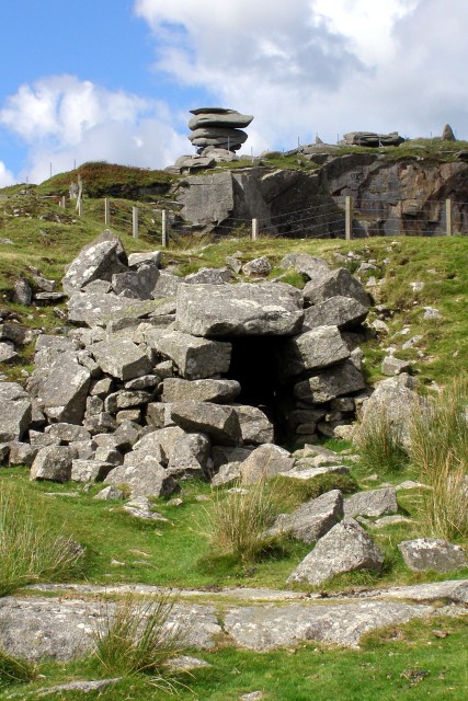
building. Daniel Gumb (d. 1776), a stonemason, lived in a cottage near the Cheesewring
The Cheesewring ( kw, Keuswask) is a granite tor in Cornwall, United Kingdom, situated on the eastern flank of Bodmin Moor on Stowe's Hill in the parish of Linkinhorne approximately one mile northwest of the village of Minions and four mile ...
; several gravestones in Linkinhorne churchyard were carved by him.
In medieval times there were chapels at Trefrize and Caradon. Arthur Langdon (1896) records a Cornish cross and a cross base at North Coombe; and another cross base at Sturt's Corner. Andrew Langdon (1996) records the cross at Northcoombe (it was set up on a stone in 1908).
Also in the parish are the Holy Well of St Melor; a 15th-century bridge over the Lynher at Plushabridge; and near Minions the Rillaton round barrow (in which Bronze Age grave goods, including a gold beaker, were discovered in 1837). The Hurlers are a group of three stone circles near Upton Cross.
The manor of Rillaton
Rillaton ( kw, Reslegh) is a hamlet in the parish of Linkinhorne in Cornwall, England. Nearby is the Bronze Age round barrow where the Rillaton Gold Cup was found in 1837.
Rillaton was the head manor of the hundred of East WivelshireThorn, Caro ...
was the head manor of the Hundred of East and one of the 17 Antiqua maneria of the Duchy of Cornwall
The Duchy of Cornwall ( kw, Duketh Kernow) is one of two royal duchies in England, the other being the Duchy of Lancaster. The eldest son of the reigning British monarch obtains possession of the duchy and the title of 'Duke of Cornwall' at ...
.
Notable people
* The wrestler James Gerry (born circa 1858) fought Samuel Rundle (Plymouth) for the championship of Cornwall in 1883. Lasting just over an hour, the match ended in a draw in the 19th round following Rundle tearing leg muscles. Gerry was reported in '' The Cornishman'' newspaper to have vanquished all the best men in America as well as many men in Cornwall. *The Church of England priest Theophilus Wodenote was vicar of Linkinhorne from 1619 to 1651, when he was sequestered from his benefice on account of his adherence to the Royalist cause. He was restored to his vicarage in 1660, and was buried at Linkinhorne on 1 October 1662.References
External links
Linkinhorne Parish website
{{authority control Civil parishes in Cornwall Holy wells in Cornwall Villages in Cornwall