|
Indonesian Archipelago
The islands of Indonesia, also known as the Indonesian Archipelago ( id, Kepulauan Indonesia) or Nusantara, may refer either to the islands comprising the country of Indonesia or to the geographical groups which include its islands. History The exact number of islands comprising Indonesia varies among definitions and sources. According to the Law No 9/1996 on Maritime Territory of Indonesia, of 17,508 officially listed islands within the territory of the Republic of Indonesia. According to a geospatial survey conducted between 2007 and 2010 by the National Coordinating Agency for Survey and Mapping (Bakorsurtanal), Indonesia has 13,466 islands. However, according to earlier survey in 2002 by National Institute of Aeronautics and Space (LAPAN), the Indonesian archipelago has 18,307 islands, and according to the CIA ''World Factbook'', there are 17,508 islands. The discrepancy of the numbers of Indonesian islands was because that the earlier surveys include " tidal islands" ... [...More Info...] [...Related Items...] OR: [Wikipedia] [Google] [Baidu] |
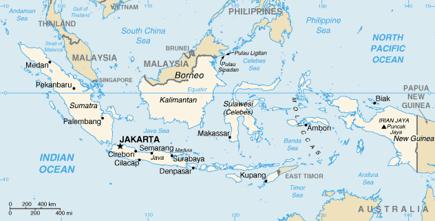
Indonesia Map
Indonesia, officially the Republic of Indonesia, is a country in Southeast Asia and Oceania between the Indian and Pacific oceans. It consists of over 17,000 islands, including Sumatra, Java, Sulawesi, and parts of Borneo and New Guinea. Indonesia is the world's largest archipelagic state and the 14th-largest country by area, at . With over 275 million people, Indonesia is the world's fourth-most populous country and the most populous Muslim-majority country. Java, the world's most populous island, is home to more than half of the country's population. Indonesia is a presidential republic with an elected legislature. It has 38 provinces, of which nine have special status. The country's capital, Jakarta, is the world's second-most populous urban area. Indonesia shares land borders with Papua New Guinea, East Timor, and the eastern part of Malaysia, as well as maritime borders with Singapore, Vietnam, Thailand, the Philippines, Australia, Palau, and India (Andaman and ... [...More Info...] [...Related Items...] OR: [Wikipedia] [Google] [Baidu] |
Suvarnadvipa
( sa, सुवर्णभूमि; Pali: '); my, သုဝဏ္ဏဘူမိ, ; km, សុវណ្ណភូមិ, ''Sovannaphoum''; and th, สุวรรณภูมิ, . is a toponym, that appears in many ancient Indian literary sources and Buddhist texts such as the '' Mahavamsa'', some stories of the Jataka tales, the ''Milinda Panha'' and the Ramayana. Though its exact location is unknown and remains a matter of debate, Suvarṇabhūmi was an important port along trade routes that run through the Indian Ocean, setting sail from the wealthy ports in Basra, Ubullah and Siraf, through Muscat, Malabar, Ceylon, the Nicobars, Kedah and on through the Strait of Malacca to fabled Suvarṇabhūmi. Historiography means 'golden land' or 'land of gold' and the ancient sources have associated it with one of a variety of places throughout the Southeast Asian region. It might also be the source of the Western concept of ''Aurea Regio'' in Claudius Ptolemy's ''Trans-Gange ... [...More Info...] [...Related Items...] OR: [Wikipedia] [Google] [Baidu] |
Sumba
Sumba ( id, Pulau Sumba) is an island in eastern Indonesia. It is one of the Lesser Sunda Islands and is in the province of East Nusa Tenggara. Sumba has an area of , and the population was 779,049 at the 2020 Census; the official estimate as at mid 2021 was 788,190. To the northwest of Sumba is Sumbawa, to the northeast, across the Sumba Strait (Selat Sumba), is Flores, to the east, across the Savu Sea, is Timor, and to the south, across part of the Indian Ocean, is Australia. History Before colonization by western Europeans in the 1500s, Sumba was inhabited by Melanesian and Austronesian people. In 1522, through the Portuguese, the first ships from Europe arrived. By 1866 Sumba belonged to the Dutch East Indies, although the island did not come under real Dutch administration until the 20th century. The Dutch mission started in 1886. One of the missionary was Douwe Wielenga. Jesuits opened a mission in Laura, West Sumba. Historically, this island exported sandalwood a ... [...More Info...] [...Related Items...] OR: [Wikipedia] [Google] [Baidu] |
Flores
Flores is one of the Lesser Sunda Islands, a group of islands in the eastern half of Indonesia. Including the Komodo Islands off its west coast (but excluding the Solor Archipelago to the east of Flores), the land area is 15,530.58 km2, and the population was 1,878,875 in the 2020 Census (including various offshore islands); the official estimate as at mid 2021 was 1,897,550. The largest towns are Maumere and Ende. The name ''Flores'' is the Portuguese and Spanish word for "Flowers". Flores is located east of Sumbawa and the Komodo islands, and west of the Solor Islands and the Alor Archipelago. To the southeast is Timor. To the south, across the Sumba Strait, is Sumba island and to the north, beyond the Flores Sea, is Sulawesi. Among all islands containing Indonesian territory, Flores is the 10th most populous after Java, Sumatra, Borneo ( Kalimantan), Sulawesi, New Guinea, Bali, Madura, Lombok, and Timor and also the 10th biggest island of Indonesia. Unt ... [...More Info...] [...Related Items...] OR: [Wikipedia] [Google] [Baidu] |
Sumbawa
Sumbawa is an Indonesian island, located in the middle of the Lesser Sunda Islands chain, with Lombok to the west, Flores to the east, and Sumba further to the southeast. Along with Lombok, it forms the province of West Nusa Tenggara, but there have been plans by the Indonesian government to split the island off into a separate province. Traditionally, the island is known as the source of sappanwood, as well as honey and sandalwood. Its savanna-like climate and vast grasslands are used to breed horses and cattle, as well as to hunt deer. Sumbawa has an area (including minor offshore islands) of (three times the size of Lombok) with a population (at the 2020 Census) of 1,561,461.Badan Pusat Statistik, Jakarta, 2021. It marks the boundary between the islands to the west, which were influenced by religion and culture spreading from India, and the region to the east that was less influenced. In particular this applies to both Hinduism and Islam. Etymology Sumbawa is a Portu ... [...More Info...] [...Related Items...] OR: [Wikipedia] [Google] [Baidu] |
Lombok
Lombok is an island in West Nusa Tenggara province, Indonesia. It forms part of the chain of the Lesser Sunda Islands, with the Lombok Strait separating it from Bali to the west and the Alas Strait between it and Sumbawa to the east. It is roughly circular, with a "tail" (Sekotong Peninsula) to the southwest, about across and a total area of about including smaller offshore islands. The provincial capital and largest city on the island is Mataram. Orang Lombok is some what similar in size and density, and shares some cultural heritage with the neighboring island of Bali to the west. However, it is administratively part of West Nusa Tenggara, along with the larger and more sparsely populated island of Sumbawa to the east. Lombok is surrounded by a number of smaller islands locally called Gili. The island was home to some 3,168,692 Indonesians as recorded in the decennial 2010 censusBiro Pusat Statistik, Jakarta, 2011. and 3,758,631 in the 2020 Census;Badan Pusat Statis ... [...More Info...] [...Related Items...] OR: [Wikipedia] [Google] [Baidu] |
Bali
Bali () is a province of Indonesia and the westernmost of the Lesser Sunda Islands. East of Java and west of Lombok, the province includes the island of Bali and a few smaller neighbouring islands, notably Nusa Penida, Nusa Lembongan, and Nusa Ceningan to the southeast. The provincial capital, Denpasar, is the most populous city in the Lesser Sunda Islands and the second-largest, after Makassar, in Eastern Indonesia. The upland town of Ubud in Greater Denpasar is considered Bali's cultural centre. The province is Indonesia's main tourist destination, with a significant rise in tourism since the 1980s. Tourism-related business makes up 80% of its economy. Bali is the only Hindu-majority province in Indonesia, with 86.9% of the population adhering to Balinese Hinduism. It is renowned for its highly developed arts, including traditional and modern dance, sculpture, painting, leather, metalworking, and music. The Indonesian International Film Festival is held every year in ... [...More Info...] [...Related Items...] OR: [Wikipedia] [Google] [Baidu] |
Lesser Sunda Islands
The Lesser Sunda Islands or nowadays known as Nusa Tenggara Islands ( id, Kepulauan Nusa Tenggara, formerly ) are an archipelago in Maritime Southeast Asia, north of Australia. Together with the Greater Sunda Islands to the west they make up the Sunda Islands. The islands are part of a volcanic arc, the Sunda Arc, formed by subduction along the Sunda Trench in the Java Sea. A bit more than 20 million people live on the islands. Etymologically, Nusa Tenggara means "Southeast Islands" from the words of ''nusa'' which means 'island' from Old Javanese language and ''tenggara'' means 'southeast'. The main Lesser Sunda Islands are, from west to east: Bali, Lombok, Sumbawa, Flores, Sumba, Savu, Rote, Timor, Atauro, Alor archipelago, Barat Daya Islands, and Tanimbar Islands. Geology The Lesser Sunda Islands consist of two geologically distinct archipelagos.Audley-Charles, M.G. (1987) "Dispersal of Gondwanaland: relevance to evolution of the Angiosperms" ''In'': Whitmo ... [...More Info...] [...Related Items...] OR: [Wikipedia] [Google] [Baidu] |
Sulawesi
Sulawesi (), also known as Celebes (), is an island in Indonesia. One of the four Greater Sunda Islands, and the world's eleventh-largest island, it is situated east of Borneo, west of the Maluku Islands, and south of Mindanao and the Sulu Archipelago. Within Indonesia, only Sumatra, Borneo, and Papua are larger in territory, and only Java and Sumatra have larger populations. The landmass of Sulawesi includes four peninsulas: the northern Minahasa Peninsula, the East Peninsula, the South Peninsula, and the Southeast Peninsula. Three gulfs separate these peninsulas: the Gulf of Tomini between the northern Minahasa and East peninsulas, the Tolo Gulf between the East and Southeast peninsulas, and the Bone Gulf between the South and Southeast peninsulas. The Strait of Makassar runs along the western side of the island and separates the island from Borneo. Etymology The name ''Sulawesi'' possibly comes from the words ''sula'' ("island") and ''besi'' ("iron") and may refer t ... [...More Info...] [...Related Items...] OR: [Wikipedia] [Google] [Baidu] |
Sarawak
Sarawak (; ) is a state of Malaysia. The largest among the 13 states, with an area almost equal to that of Peninsular Malaysia, Sarawak is located in northwest Borneo Island, and is bordered by the Malaysian state of Sabah to the northeast, Kalimantan (the Indonesian portion of Borneo) to the south, and Brunei in the north. The capital city, Kuching, is the largest city in Sarawak, the economic centre of the state, and the seat of the Sarawak state government. Other cities and towns in Sarawak include Miri, Sibu, and Bintulu. As of 2021, the population of Sarawak was estimated to be around 2.45 million. Sarawak has an equatorial climate with tropical rainforests and abundant animal and plant species. It has several prominent cave systems at Gunung Mulu National Park. Rajang River is the longest river in Malaysia; Bakun Dam, one of the largest dams in Southeast Asia, is located on one of its tributaries, the Balui River. Mount Murud is the highest point in the state ... [...More Info...] [...Related Items...] OR: [Wikipedia] [Google] [Baidu] |
Sabah
Sabah () is a state of Malaysia located in northern Borneo, in the region of East Malaysia. Sabah borders the Malaysian state of Sarawak to the southwest and the North Kalimantan province of Indonesia to the south. The Federal Territory of Labuan is an island just off Sabah's west coast. Kota Kinabalu is the state capital city, the economic centre of the state, and the seat of the Sabah state government. Other major towns in Sabah include Sandakan and Tawau. The 2020 census recorded a population of 3,418,785 in the state. It has an equatorial climate with tropical rainforests, abundant with animal and plant species. The state has long mountain ranges on the west side which forms part of the Crocker Range National Park. Kinabatangan River, the second longest river in Malaysia runs through Sabah. The highest point of Sabah, Mount Kinabalu is also the highest point of Malaysia. The earliest human settlement in Sabah can be traced back to 20,000–30,000 years ago along t ... [...More Info...] [...Related Items...] OR: [Wikipedia] [Google] [Baidu] |
Malaysia
Malaysia ( ; ) is a country in Southeast Asia. The federation, federal constitutional monarchy consists of States and federal territories of Malaysia, thirteen states and three federal territories, separated by the South China Sea into two regions: Peninsular Malaysia and Borneo's East Malaysia. Peninsular Malaysia shares a land and maritime Malaysia–Thailand border, border with Thailand and Maritime boundary, maritime borders with Singapore, Vietnam, and Indonesia. East Malaysia shares land and maritime borders with Brunei and Indonesia, and a maritime border with the Philippines and Vietnam. Kuala Lumpur is the national capital, the country's largest city, and the seat of the Parliament of Malaysia, legislative branch of the Government of Malaysia, federal government. The nearby Planned community#Planned capitals, planned capital of Putrajaya is the administrative capital, which represents the seat of both the Government of Malaysia#Executive, executive branch (the Cabine ... [...More Info...] [...Related Items...] OR: [Wikipedia] [Google] [Baidu] |


