|
Eastern Herzegovinian Dialect
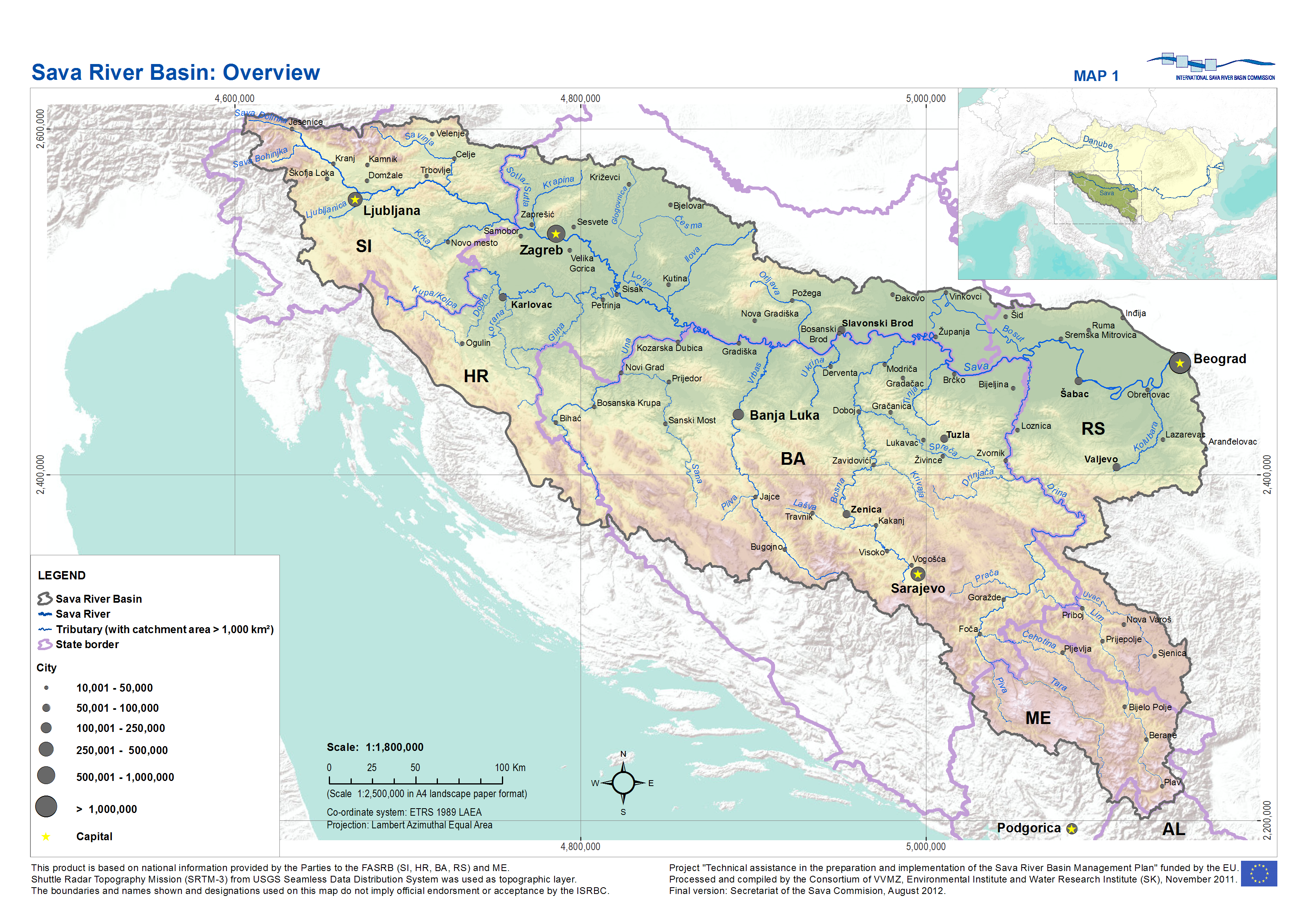
The Eastern Herzegovinian dialect (, Serbo-Croatian: ''istočnohercegovački'' / источнохерцеговачки) is the most widespread subdialect of the Shtokavian dialect of Serbo-Croatian, both by territory and the number of speakers. It is the dialectal basis for all modern literary Serbo-Croatian standards: Bosnian, Croatian, Serbian, and Montenegrin (the latter only partially codified). Distribution It covers large areas of Croatia, Bosnia-Herzegovina, Serbia and Montenegro. It is also spoken in four villages in White Carniola, Slovenia ( Miliči, Bojanci, Marindol and Paunoviči), the inhabitants of which are descendants of Uskoks. It is composed of two larger zones that are territorially separated: * Southeastern zone, where it originated from (eastern Herzegovina, western Montenegro, western Serbia, eastern Bosnia, Posavinan Podrinje) * Northwestern zone (western and northwestern Bosnia, northern Dalmatia with Gorski Kotar, narrower strips of Croatia, ... [...More Info...] [...Related Items...] OR: [Wikipedia] [Google] [Baidu] |
Pavle Ivić
Pavle Ivić ( sr-cyr, Павле Ивић, ; 1 December 1924 – 19 September 1999) was a Serbian South Slavic dialectologist and phonologist. Biography Both his field work and his synthesizing studies were extensive and authoritative. A few of his best-known publications are: * ''Die serbokroatischen Dialekte, ihre Struktur und Entwicklung, Gravenhage, Mouton, 1958'' * ''Srpski narod i njegov jezik (The Serbian People and Their Language). Belgrade, 1971;'' * ''Word and sentence prosody in Serbocroatian, by Ilse Lehiste and Pavle Ivić. Cambridge, Mass.: MIT Press, 1986.'' He edited many periodicals and scholarly series, and was an important figure in the All-Slavic Linguistic Atlas project. He was an authority on the standardization of the Serbian language. He frequently lectured in the U.S. and other countries, and was an Honorary Member of the Linguistic Society of America. A member of the Serbian Academy of Sciences and Arts The Serbian Academy of Sciences and Arts ( ... [...More Info...] [...Related Items...] OR: [Wikipedia] [Google] [Baidu] |
Montenegro
) , image_map = Europe-Montenegro.svg , map_caption = , image_map2 = , capital = Podgorica , coordinates = , largest_city = capital , official_languages = Montenegrin , languages2_type = Languages in official use , languages2 = , ethnic_groups = , ethnic_groups_year = 2011 , religion = , religion_year = 2011 , demonym = Montenegrin , government_type = Unitary parliamentary republic , leader_title1 = President , leader_name1 = Milo Đukanović , leader_title2 = Prime Minister , leader_name2 = Dritan Abazović (acting) , leader_title3 = Speaker , leader_name3 = Danijela Đurović , legislature = Skupština , sovereignty_type = Establishment history , established_event1 = Principality of Duklja , established_date1 ... [...More Info...] [...Related Items...] OR: [Wikipedia] [Google] [Baidu] |
Slavonia
Slavonia (; hr, Slavonija) is, with Dalmatia, Croatia proper, and Istria, one of the four historical regions of Croatia. Taking up the east of the country, it roughly corresponds with five Croatian counties: Brod-Posavina, Osijek-Baranja, Požega-Slavonia, Virovitica-Podravina, and Vukovar-Syrmia, although the territory of the counties includes Baranya, and the definition of the western extent of Slavonia as a region varies. The counties cover or 22.2% of Croatia, inhabited by 806,192—18.8% of Croatia's population. The largest city in the region is Osijek, followed by Slavonski Brod and Vinkovci. Slavonia is located in the Pannonian Basin, largely bordered by the Danube, Drava, and Sava rivers. In the west, the region consists of the Sava and Drava valleys and the mountains surrounding the Požega Valley, and plains in the east. Slavonia enjoys a moderate continental climate with relatively low precipitation. After the fall of the Western Roman Empire, whi ... [...More Info...] [...Related Items...] OR: [Wikipedia] [Google] [Baidu] |
Dalmatia
Dalmatia (; hr, Dalmacija ; it, Dalmazia; see names in other languages) is one of the four historical regions of Croatia, alongside Croatia proper, Slavonia, and Istria. Dalmatia is a narrow belt of the east shore of the Adriatic Sea, stretching from the island of Rab in the north to the Bay of Kotor in the south. The Dalmatian Hinterland ranges in width from fifty kilometres in the north, to just a few kilometres in the south; it is mostly covered by the rugged Dinaric Alps. Seventy-nine islands (and about 500 islets) run parallel to the coast, the largest (in Dalmatia) being Brač, Pag, and Hvar. The largest city is Split, followed by Zadar and Šibenik. The name of the region stems from an Illyrian tribe called the Dalmatae, who lived in the area in classical antiquity. Later it became a Roman province, and as result a Romance culture emerged, along with the now-extinct Dalmatian language, later largely replaced with related Venetian. With the arrival of Cr ... [...More Info...] [...Related Items...] OR: [Wikipedia] [Google] [Baidu] |
Podrinje
Podrinje ( Serbian Cyrillic: Подриње) is the Slavic name of the Drina river basin, known in English as the Drina Valley. The Drina basin is shared between Bosnia and Herzegovina and Serbia, with majority of its territory being located in Eastern Bosnia, entire Upper Drina course and majority of the Middle course, while the Lower Drina course is shared between two countries,with the river representing border. The part of the Drina basin located in Bosnia and Herzegovina is also called Eastern Bosnia. History Between 1918 and 1922, Podrinje District, with its seat in Šabac, was one of the districts of the Kingdom of Serbs, Croats and Slovenes. The district comprised the north-western part of present-day Šumadija and Western Serbia. Between 1922 and 1929, Podrinje Oblast existed in roughly the same area also with its seat in Šabac. In 1929, a large province of the Kingdom of Yugoslavia known as the Drina Banovina was formed with its capital in Sarajevo. Drina Banovin ... [...More Info...] [...Related Items...] OR: [Wikipedia] [Google] [Baidu] |
Posavina
Posavina ( sr-cyr, Посавина) is a geographical region that stretches along the Sava river, encompassing only the inner areas of the Sava river basin, that are adjacent or near to the Sava river itself, namely catch region spanning from the Julian Alps in the northwest to the confluence with the Danube in the southeast. It passes through several countries of former Yugoslavia, namely Slovenia, Croatia, Bosnia and Herzegovina and Serbia. In Slovene, the term Posavina is not used to describe the parts of Slovenia that lie by the Sava river. Instead, the terms Posavje and Zasavje are used. Geography Geography of the Posavina region is defined by geological features of the central (inner) zones of the Sava river basin, that are near or adjacent to the Sava river itself. The region is stretched along the Sava river, that flows from west to east, connecting valleys and plains in transitional regions between the Dinaric Mountains and the Pannonian Plain. Geographical ... [...More Info...] [...Related Items...] OR: [Wikipedia] [Google] [Baidu] |
Bosnia
Bosnia and Herzegovina ( sh, / , ), abbreviated BiH () or B&H, sometimes called Bosnia–Herzegovina and Pars pro toto#Geography, often known informally as Bosnia, is a country at the crossroads of Southern Europe, south and southeast Europe, located in the Balkans. Bosnia and Herzegovina borders Serbia to the east, Montenegro to the southeast, and Croatia to the north and southwest. In the south it has a narrow coast on the Adriatic Sea within the Mediterranean Sea, Mediterranean, which is about long and surrounds the town of Neum. Bosnia (region), Bosnia, which is the inland region of the country, has a moderate continental climate with hot summers and cold, snowy winters. In the central and eastern regions of the country, the geography is mountainous, in the northwest it is moderately hilly, and in the northeast it is predominantly flat. Herzegovina, which is the smaller, southern region of the country, has a Mediterranean climate and is mostly mountainous. Sarajevo is t ... [...More Info...] [...Related Items...] OR: [Wikipedia] [Google] [Baidu] |
Herzegovina
Herzegovina ( or ; sh-Latn-Cyrl, Hercegovina, separator=" / ", Херцеговина, ) is the southern and smaller of two main geographical region of Bosnia and Herzegovina, the other being Bosnia. It has never had strictly defined geographical or cultural-historical borders, nor has it ever been defined as an administrative whole in the geopolitical and economic subdivision of Bosnia and Herzegovina. Bosnia, the larger of the two regions, lies to the north of Herzegovina; the Croatian region of Dalmatia lies to the southwest; the Montenegrin region of Old Herzegovina lies to the southeast. The land area of Herzegovina is around , or around 23–24% of the country. The largest city is Mostar, in the center of the region. Other large settlements include Trebinje, Široki Brijeg, Ljubuški, Čapljina, Konjic and Posušje. Etymology The name (or ''Herzegovina'' in English) stems from German (the German term for a duke; sh, vojvoda), and means a land ruled and/or ... [...More Info...] [...Related Items...] OR: [Wikipedia] [Google] [Baidu] |
Uskoks
The Uskoks ( hr, Uskoci, , singular: ; notes on naming) were irregular soldiers in Habsburg Croatia that inhabited areas on the eastern Adriatic coast and surrounding territories during the Ottoman wars in Europe. Bands of Uskoks fought a guerrilla war against the Ottomans, and they formed small units and rowed swift boats. Since the uskoks were checked on land and were rarely paid their annual subsidy, they resorted to acts of piracy. The exploits of the Uskoks contributed to a renewal of war between Venice and the Ottoman Empire (1571–1573). An extremely curious picture of contemporary manners is presented by the Venetian agents, whose reports on this war resemble a knightly chronicle of the Middle Ages. These chronicles contain information pertaining to single combats, tournaments and other chivalrous adventures. Many of these troops served abroad. After a series of incidents that escalated into the Uskok War (1615–1618), the Uskok activity in their stronghold of ... [...More Info...] [...Related Items...] OR: [Wikipedia] [Google] [Baidu] |
Paunoviči
Paunoviči () is a small settlement on the left bank of the Kolpa River in the Municipality of Črnomelj in the White Carniola area of southeastern Slovenia. The area is part of the traditional region of Lower Carniola and is now included in the Southeast Slovenia Statistical Region The Southeast Slovenia Statistical Region ( sl, Jugovzhodna Slovenija statistična regija) is a statistical region in southeast Slovenia. It is the largest statistical region. The development of this region is largely the result of industry (the au .... References External linksPaunoviči on Geopedia Populated places in the Municipality of Črnomelj Serb communities in Slovenia {{Crnomelj-geo-stub ... [...More Info...] [...Related Items...] OR: [Wikipedia] [Google] [Baidu] |
Marindol
Marindol () is a settlement on the terrace above the left bank of the Kolpa River in the Municipality of Črnomelj in the White Carniola area of southeastern Slovenia. The area is part of the traditional region of Lower Carniola and is now included in the Southeast Slovenia Statistical Region The Southeast Slovenia Statistical Region ( sl, Jugovzhodna Slovenija statistična regija) is a statistical region in southeast Slovenia. It is the largest statistical region. The development of this region is largely the result of industry (the au .... Name Marindol was first attested in written sources in 1477 as ''Marintall'' (and in 1490 as ''Marental''). The name is a compound formed from ''*Mari(ji)n dol'' (literally, 'Mary's valley'). The settlement was also once known as ''Šobatovci'' or ''Šobatovo selo'', or ''Šabotovo/Šobotovo selo'', cited as ''Shebatova sella'' in 1674.Terseglav, Marko. 1996. ''Uskoška pesemska dediščina Bele Krajine''. Ljubljana: ZRC SAZU, pp. 22–23. ... [...More Info...] [...Related Items...] OR: [Wikipedia] [Google] [Baidu] |


