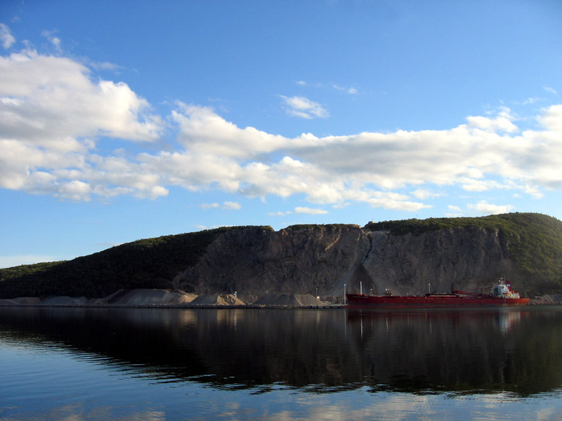
Strait of Canso on:
[Wikipedia]
[Google]
[Amazon]
 The Strait of Canso (also Gut of Canso or Canso Strait, also called Straits of Canceau or Canseaux until the early 20th century) is a
Strait of Canso - Economic Development Studies
(online collection of studies of the Strait of Canso area) {{Coord, 45, 35, 50, N, 61, 22, 38, W, display=title, region:CA_type:waterbody_source:dewiki_scale:250000
 The Strait of Canso (also Gut of Canso or Canso Strait, also called Straits of Canceau or Canseaux until the early 20th century) is a
 strait
A strait is an oceanic landform connecting two seas or two other large areas of water. The surface water generally flows at the same elevation on both sides and through the strait in either direction. Most commonly, it is a narrow ocean channe ...
located in the province of Nova Scotia
Nova Scotia ( ; ; ) is one of the thirteen provinces and territories of Canada. It is one of the three Maritime provinces and one of the four Atlantic provinces. Nova Scotia is Latin for "New Scotland".
Most of the population are native Eng ...
, Canada. It divides the Nova Scotia peninsula
The Nova Scotia peninsula is a peninsula on the Atlantic coast of North America.
Location
The Nova Scotia peninsula is part of the province of Nova Scotia, Canada and is connected to the neighbouring province of New Brunswick through the Isth ...
from Cape Breton Island
Cape Breton Island (french: link=no, île du Cap-Breton, formerly '; gd, Ceap Breatainn or '; mic, Unamaꞌki) is an island on the Atlantic coast of North America and part of the province of Nova Scotia, Canada.
The island accounts for 18. ...
.
It is a long thin channel approximately 27 kilometres long and averaging 3 kilometres wide (1 km at its narrowest). The strait connects Chedabucto Bay
Chedabucto Bay is a large bay on the eastern coast of mainland Nova Scotia between the Atlantic Ocean and the Strait of Canso next to Guysborough County. At the entrance to Chedabucto Bay is the community of Canso at the head is the community ...
on the Atlantic Ocean
The Atlantic Ocean is the second-largest of the world's five oceans, with an area of about . It covers approximately 20% of Earth's surface and about 29% of its water surface area. It is known to separate the " Old World" of Africa, Europe ...
to St. George's Bay on the Northumberland Strait
The Northumberland Strait (French: ''détroit de Northumberland'') is a strait in the southern part of the Gulf of Saint Lawrence in eastern Canada. The strait is formed by Prince Edward Island and the gulf's eastern, southern, and western sho ...
, a sub basin of the Gulf of St. Lawrence.
The strait is extremely deep (200+ feet) with two major communities at Port Hawkesbury
Port Hawkesbury (Scottish Gaelic: ''Baile a' Chlamhain'') is a municipality in southern Cape Breton Island, Nova Scotia, Canada. While within the historical county of Inverness, it is not part of the Municipality of Inverness County.
History ...
on the eastern side facing Mulgrave on the western side, both ports. The strait is crossed by the Canso Causeway
The Canso Causeway (''Cabhsair Chanso'' in Gaelic) is a rock-fill causeway crossing the Strait of Canso, connecting Cape Breton Island by road to the Nova Scotia peninsula. Its crest thickness is , carrying the two vehicle traffic lanes of th ...
for vehicular and rail traffic, opened in 1955. The Canso Canal
The Canso Canal is a short canal located in Nova Scotia, Canada.
Canal location
The Canso Canal is in the Strait of Canso, on the eastern side of the Canso Causeway, a rock-fill causeway which opened in 1955 to carry a 2-lane highway and a si ...
allows ships to pass through the causeway, and this can accommodate any vessel capable of transiting the St. Lawrence Seaway.
An account of early settlement in the area is given in the letters of local resident Henry Nicholas Paint
Henry Nicholas Paint (10 April 1830 – 29 September 1921) was a Canadian politician, shipowner and merchant.
Career
Henry Paint was the son of Nicholas Paint, JP, by Mary Le Messurier, both of old Guernsey families which had been tradin ...
(1830-1921), Member of Parliament for Richmond county and merchant, whose father Nicholas secured valuable land grants and settled in a stone-built house at Belle Vue in 1817. Port Hawkesbury, at first known as Ship Harbour, emerged as a shipbuilding and boatbuilding port on the Strait in the 19th century with firms such as H.W. Embree and Sons Henry W. Embree and Sons, Boatbuilders, was a boat yard in Port Hawkesbury, Nova Scotia, that operated from 1859 to 1948. The youngest son of a boatbuilding family, Henry Embree established his own boat yard between Brown and Pitt Streets, on the P ...
producing distinctive fishing boats that came to be known as "Canso Boats" after the Strait.
References
External links
*Strait of Canso - Economic Development Studies
(online collection of studies of the Strait of Canso area) {{Coord, 45, 35, 50, N, 61, 22, 38, W, display=title, region:CA_type:waterbody_source:dewiki_scale:250000
Canso
The Civil Air Navigation Services Organisation (CANSO) is a representative body of companies that provide air traffic control. It represents the interests of Air Navigation Service Providers (ANSPs). CANSO members are responsible for supporting ov ...
Landforms of Antigonish County, Nova Scotia
Landforms of Guysborough County, Nova Scotia
Landforms of Inverness County, Nova Scotia
Landforms of Richmond County, Nova Scotia
Straits of the Atlantic Ocean
Geographic regions of Nova Scotia