Sitlington on:
[Wikipedia]
[Google]
[Amazon]
 Sitlington, historically Shitlington, was a

 Sitlington covers 3412 acres in the valley of the River Calder. Netherton and Midgley are in the south-west of the township separated from Overton and Middlestown in the north east by the wooded valley of the Coxley Beck. The A642 road between
 Sitlington, historically Shitlington, was a
 township
A township is a kind of human settlement or administrative subdivision, with its meaning varying in different countries.
Although the term is occasionally associated with an urban area, that tends to be an exception to the rule. In Australia, C ...
in the ancient ecclesiastical parish of Thornhill in the wapentake
A hundred is an administrative division that is geographically part of a larger region. It was formerly used in England, Wales, some parts of the United States, Denmark, Southern Schleswig, Sweden, Finland, Norway, the Bishopric of Ösel–Wiek, ...
of Agbrigg and Morley in the West Riding of Yorkshire
The West Riding of Yorkshire is one of three historic subdivisions of Yorkshire, England. From 1889 to 1974 the administrative county County of York, West Riding (the area under the control of West Riding County Council), abbreviated County ...
comprising the villages and hamlets of Middlestown, Netherton, Overton and Midgley
Midgley () is a hill-top village in Calderdale, West Yorkshire, England. It is situated approximately east from Burnley and west-north-west of Halifax, and just north of the A646 road. Nearby villages are Mytholmroyd to the west-south-west ...
. The ''h'' was dropped from Shitlington and Sitlington was adopted in 1929 with the approval of the county council
A county council is the elected administrative body governing an area known as a county. This term has slightly different meanings in different countries.
Ireland
The county councils created under British rule in 1899 continue to exist in Irel ...
. The population of the civil parish at the 2011 census was 5,963.
History

Toponymy
Shitlington has Anglo-Saxon origins. It possibly began as the settlement, ''tun'', connected with ''scyttel'' (either a personal name or a bar or gate which bolts shut) or might mean a farm or settlement on a steep slope. The village is recorded as "Schelingtone" in the ''Domesday Book
Domesday Book () – the Middle English spelling of "Doomsday Book" – is a manuscript record of the "Great Survey" of much of England and parts of Wales completed in 1086 by order of King William I, known as William the Conqueror. The manus ...
''. Other spellings have included Shytlington, Sittlington, Schetlinton, and Scyllinton.
Netherton was recorded as Schiteliton Inferior in the 13th century and subsequently as Nether Shitlington. It means the "lower town". Middlestown was Midelshitelington in the 14th century and a 15th-century document records it as Mydleston. Overton was recorded as Overshitlyngton in the 11th century. Midgley was Migelie in the 12th century and could mean either the "large pasture" or "midge infested clearing". Coxley, recorded as Cockesclo at the end of the 12th century, meant a "dell where there were cocks". Hollinhurst possibly means the "holly wood".
Medieval
Shitlington was part of the extensive Manor of Wakefield. At theDomesday survey
Domesday Book () – the Middle English spelling of "Doomsday Book" – is a manuscript record of the "Great Survey" of much of England and parts of Wales completed in 1086 by order of King William I, known as William the Conqueror. The manusc ...
its six oxgang
An oxgang or bovate ( ang, oxangang; da, oxgang; gd, damh-imir; lat-med, bovāta) is an old land measurement formerly used in Scotland and England as early as the 16th century sometimes referred to as an oxgait. It averaged around 20 English a ...
s of land was described as waste. Within the township were three manors, Netherton, New Hall and Overton belonged to a family named Everingham. New Hall, once a moated manor house became the property of Sir Thomas Wortley and subsequently the Earls of Wharncliffe. Land changed hands frequently and the Armitages bought land in Middlestown and Overton in 1598.
Mining
Inmedieval
In the history of Europe, the Middle Ages or medieval period lasted approximately from the late 5th to the late 15th centuries, similar to the post-classical period of global history. It began with the fall of the Western Roman Empire ...
times monks from Kirkstall
Kirkstall is a north-western suburb of Leeds, West Yorkshire, England, on the eastern side of the River Aire. The area sits in the Kirkstall ward of Leeds City Council and Leeds West parliamentary constituency, represented by Rachel Reeves. T ...
, Rievaulx and Byland Abbey
Byland Abbey is a ruined abbey and a small village in the Ryedale district of North Yorkshire, England, in the North York Moors National Park.
History
It was founded as a Savigniac abbey in January 1135 and was absorbed by the Cistercian orde ...
s and St John's Priory in Pontefract obtained ironstone from Sitlington. The seam of ironstone lay between the Joan and Flockton coal seams in the area. Ironstone was mined at Emroyd from 1798. A blast furnace powered by a steam engine built there closed around 1821. Emroyd was then exploited for its coal.
Geography and geology
 Sitlington covers 3412 acres in the valley of the River Calder. Netherton and Midgley are in the south-west of the township separated from Overton and Middlestown in the north east by the wooded valley of the Coxley Beck. The A642 road between
 Wakefield
Wakefield is a cathedral city in West Yorkshire, England located on the River Calder. The city had a population of 99,251 in the 2011 census.https://www.nomisweb.co.uk/census/2011/ks101ew Census 2011 table KS101EW Usual resident population, ...
and Huddersfield
Huddersfield is a market town in the Kirklees district in West Yorkshire, England. It is the administrative centre and largest settlement in the Kirklees district. The town is in the foothills of the Pennines. The River Holme's confluence into ...
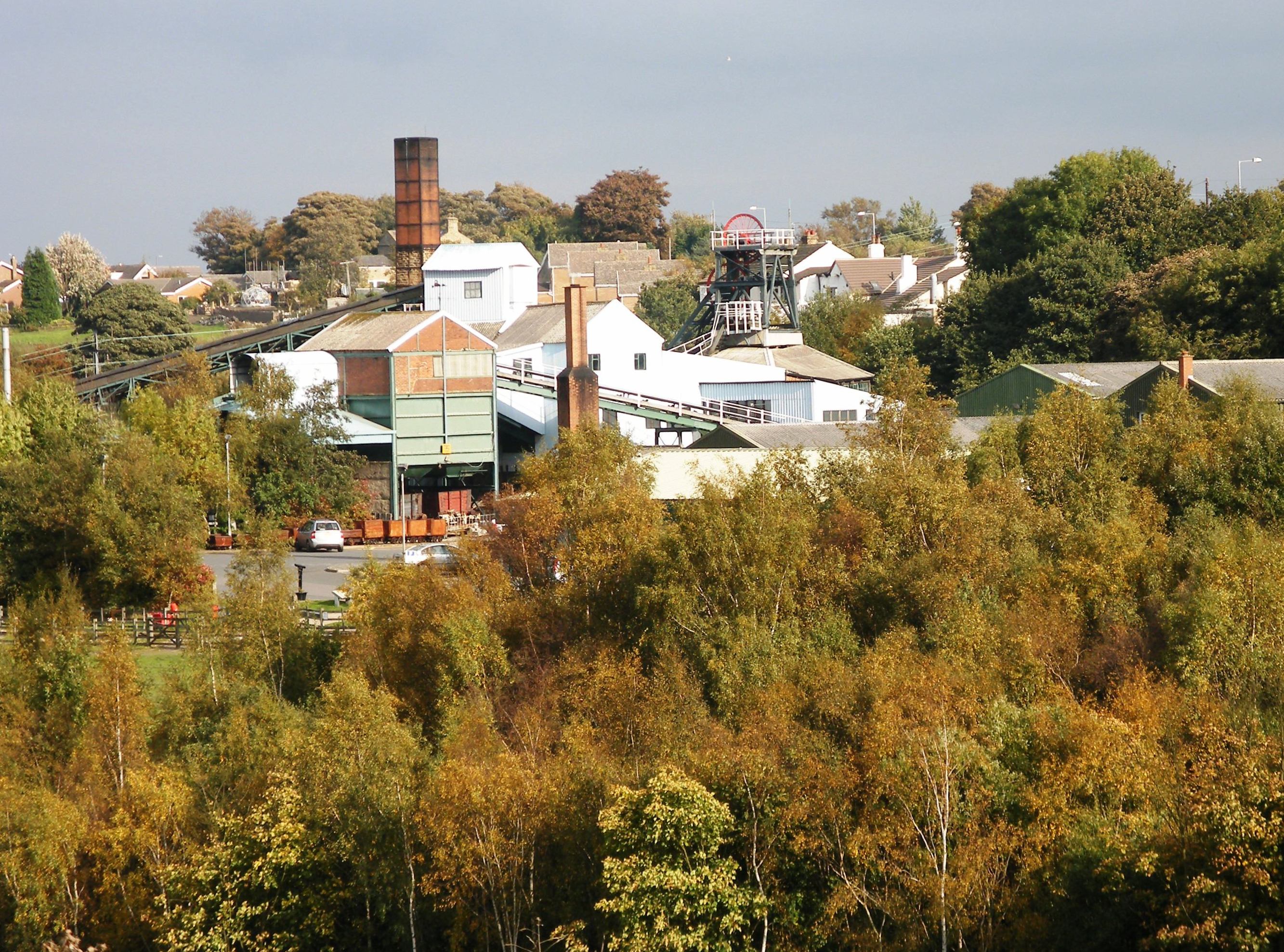
passes through Middlestown and by the National Mining Museum at Caphouse Colliery
Caphouse Colliery, originally known as Overton Colliery, was a coal mine in Overton, near Wakefield, West Yorkshire, England. It was situated on the Denby Grange estate owned by the Lister Kaye family, and was worked from the 18th century until ...
in Overton. It has a junction with the B6117 at Horbury Bridge which passes through Netherton and Midgley.
The geology of the area comprises the Coal Measures of the South Yorkshire Coalfield
The South Yorkshire Coalfield is so named from its position within Yorkshire. It covers most of South Yorkshire, West Yorkshire and a small part of North Yorkshire. The exposed coalfield outcrops in the Pennine foothills and dips under Permian ro ...
, sandstone
Sandstone is a clastic sedimentary rock composed mainly of sand-sized (0.0625 to 2 mm) silicate grains. Sandstones comprise about 20–25% of all sedimentary rocks.
Most sandstone is composed of quartz or feldspar (both silicates ...
, Millstone Grit and in medieval
In the history of Europe, the Middle Ages or medieval period lasted approximately from the late 5th to the late 15th centuries, similar to the post-classical period of global history. It began with the fall of the Western Roman Empire ...
times, ironstone was got from the Tankersley seam that outcrops in Overton and Emroyd Common in Middlestown. Opencast mining took place in 1975. Caphouse Colliery
Caphouse Colliery, originally known as Overton Colliery, was a coal mine in Overton, near Wakefield, West Yorkshire, England. It was situated on the Denby Grange estate owned by the Lister Kaye family, and was worked from the 18th century until ...
, in the west of the township, stopped produced coal in 1985 and instead became the National Coal Mining Museum for England
The National Coal Mining Museum for England is based at the site of Caphouse Colliery in Overton, Wakefield, West Yorkshire, England. It opened in 1988 as the Yorkshire Mining Museum and was granted national status in 1995.
History
Caphouse C ...
. Denby Grange Colliery, mid-way between Netherton and Midgley, closed in 1991.
See also
*Listed buildings in Sitlington
Sitlington is a civil parish in the metropolitan borough of the City of Wakefield, West Yorkshire, England. The parish contains ten listed buildings that are recorded in the National Heritage List for England. Of these, two are listed at G ...
References
Notes Bibliography * {{coord, 53.64, -1.58, region:GB_type:city, display=title Civil parishes in West Yorkshire Geography of the City of Wakefield