Murerplan Zuerich on:
[Wikipedia]
[Google]
[Amazon]
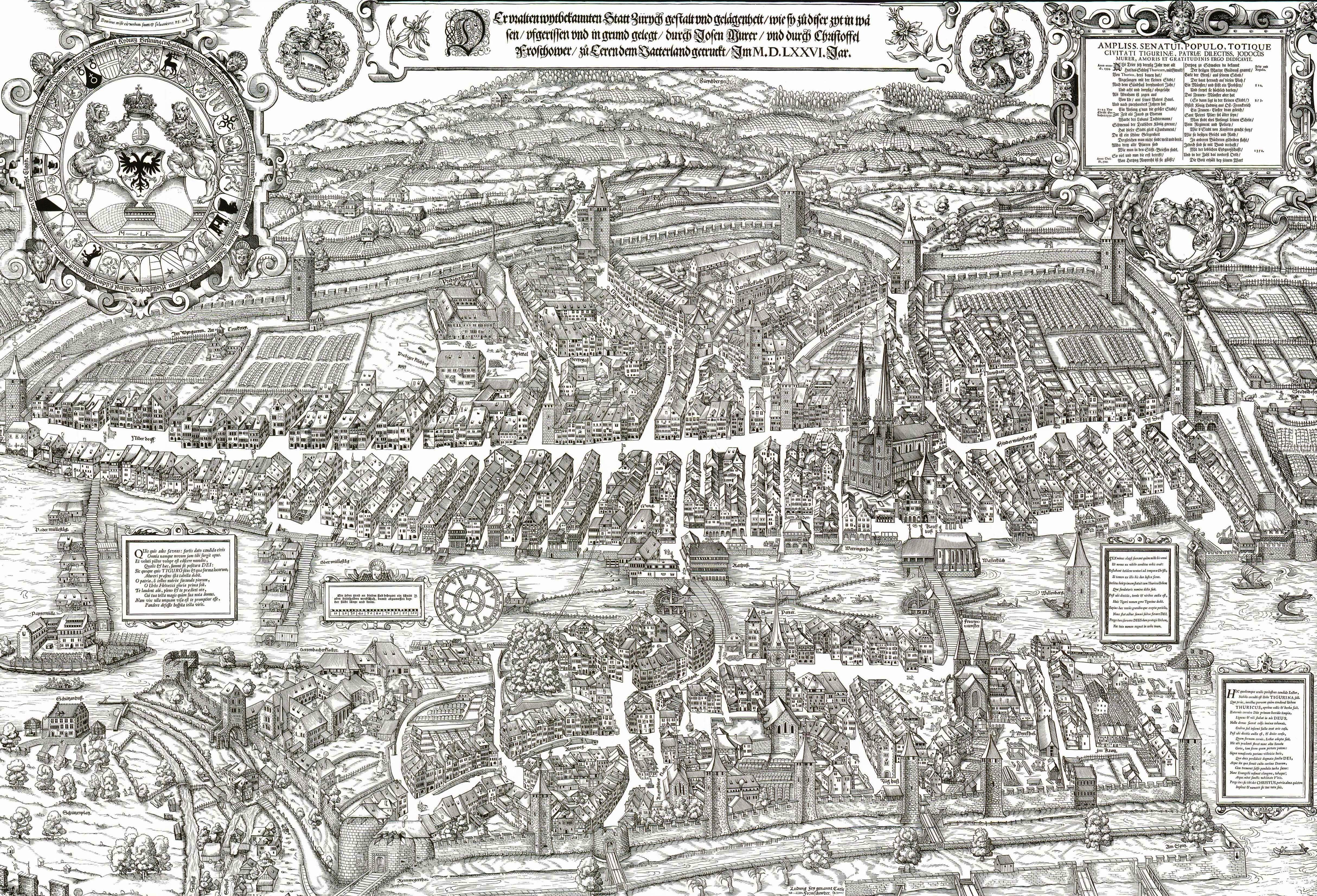
 The Murerplan is a map of
File:Murer Wappenscheibe.jpg, Detail: coat of arms of Zürich (colours added)
File:Druck Grossmünster.jpg, Detail: Grossmünster
File:Barfüsser Murerplan.jpg, Detail: ''Barfüsser'' Abbey in Zürich
File:Zürich - Murerplan - Ausschnitt Bilgeriturm.jpg, Detail: Neumarkt and
plaene/a33_legende_murerplan.pdf
 The Murerplan is a map of
 Zürich
Zürich () is the list of cities in Switzerland, largest city in Switzerland and the capital of the canton of Zürich. It is located in north-central Switzerland, at the northwestern tip of Lake Zürich. As of January 2020, the municipality has 43 ...
, printed in 1576 by Jos Murer (1530-1580).
It was combined from six pearwood plates measuring 45 cm squared each. A smaller extra plate was made for the Grossmünster, which would otherwise have been divided between four plates.
The original plates have not been preserved. The plates of a second edition of 1610 survive.
Description
The map is entitled :''Der uralten wytbekannten Statt Zurych gestalt und gelaegenhait / wie sy zuo diser zyt in waesen / ufgerissen und in grund gelegt / durch Josen Murer / und durch Christoffel Froschaower / zuo Eeren dem Vatterland getruckt / Im M.D.LXXVI. Jar.'' :"The aspect and situation of the ancient and famous town of Zürich / as it has been at this time / drawn and etched / by Jos Murer / and by Christoph Froschauer / printed for the glory of the nation / AD 1576" The plan is extremely detailed, showing the aspect of every house, and is a unique historical source for the condition of the city in the 16th century. Zürich had essentially preserved its medieval (13th-century) aspect until that time (except for the frequent replacement of earlier wooden buildings by stone houses), and major expansions and city planning began only in the 17th century, with the addition oframpart
Rampart may refer to:
* Rampart (fortification), a defensive wall or bank around a castle, fort or settlement
Rampart may also refer to:
* "O'er the Ramparts We Watched" is a key line from "The Star-Spangled Banner", the national anthem of the ...
s during the Thirty Years' War
The Thirty Years' War was one of the longest and most destructive conflicts in European history
The history of Europe is traditionally divided into four time periods: prehistoric Europe (prior to about 800 BC), classical antiquity (80 ...
.
The plan looks east over the city (north to the left), with the moat at the bottom of the plan corresponding to the present Bahnhofstrasse
Bahnhofstrasse is Zürich's main downtown street and one of the world's most expensive and exclusive shopping avenues. In 2011, a study named the ''Bahnhofstrasse'' the most expensive street for retail property in Europe, and the third most expens ...
, with the Rennweg gate, the main entry to the city. The bottom left corner shows the confluence of the Sihl
The Sihl is a Swiss river that rises near the Druesberg mountain in the canton of Schwyz, and eventually flows into the Limmat in the centre of the city of Zürich. It has a length of , including the Sihlsee reservoir, through which the river flow ...
and Limmat
The Limmat is a river in Switzerland. The river commences at the outfall of Lake Zurich, in the southern part of the city of Zurich. From Zurich it flows in a northwesterly direction, after 35 km reaching the river Aare. The confluenc ...
rivers, the location of the present Zürich Hauptbahnhof.
Gallery
Grimmenturm
Grimmenturm is a medieval tower and restaurant situated at Neumarkt in Zürich, Switzerland.
Location
The ''Grimmenturm'' building is situated at Neumarkt (Spiegelgasse 31, 8001 Zürich) in the ''Altstadt'' of Zürich on the right shore of the ...
File:Murerplan - Wiedikon.jpg, Western and southern areas around the city of Zürich on the so-called ''Kantonskarte'' (''Zürcherkarte'') by Jos Murer (1566)
File:Uetliberg Kantonskarte 1566.jpg, Detail: Uetliberg
__NOTOC__
The Uetliberg (also known as Üetliberg) is a mountain in the Swiss plateau, part of the Albis chain, rising to . The mountain offers a panoramic view of the entire city of Zürich (to the northeast of its summit) and the Lake of Zur ...
and Albis showing the castles called ''Uetliburg'', ''Friesenburg'', ''Baldern'' and ''Manegg''
File:Murerplan - Oberes Zürichseegebiet IMG 2383.JPG, Rapperswil, Seedamm The Rapperswil Seedamm is the partially artificial causeway and bridge at the most narrow area of Lake Zurich, between Hurden (SZ) and Rapperswil (SG). The Seedamm carries a road and a railway across the lake, with the railway being used by the ...
respectively wooden bridge
A timber bridge or wooden bridge is a bridge that uses timber or wood as its principal structural material. One of the first forms of bridge, those of timber have been used since ancient times.
History
The most ancient form of timber bridge is ...
, upper Lake Zürich
__NOTOC__
Lake Zurich ( Swiss German/Alemannic: ''Zürisee''; German: ''Zürichsee''; rm, Lai da Turitg) is a lake in Switzerland, extending southeast of the city of Zürich. Depending on the context, Lake Zurich or ''Zürichsee'' can be used to ...
(''Obersee'') and Jona river (''Jonen'') on ''Kantonskarte''
File:Jos Murer.jpg, Jos Murer, by Conrad Meyer (1675)
See also
plaene/a33_legende_murerplan.pdf
External links
{{Commons category-inline 16th-century maps and globes History of Zürich 1576 works