|
Tierra Helada
Tierra Helada (Spanish for "frozen land"), also known as Tierra Nevada (Spanish for "snowy land"), is a term used in Latin America to refer to the highest places found within the Andes mountains. The ''Tierra Helada'' comprises the montane grasslands and shrublands, sunis, punas and páramos between the tree line The tree line is the edge of the habitat at which trees are capable of growing. It is found at high elevations and high latitudes. Beyond the tree line, trees cannot tolerate the environmental conditions (usually cold temperatures, extreme snowp ... and the snow line. The term ''tierra helada'' is accurate from a climatological standpoint, as its land is indeed "frozen", situated above the snow line. In the northern Andes, the latter is located at an altitude of approximately 15,000 ft (or about 4,500 m).Zech, W. and Hintermaier-Erhard, G. (2002); Böden der Welt – Ein Bildatlas, Heidelberg, p. 98. The Peruvian geographer Javier Pulgar Vidal (Altitudinal zonati ... [...More Info...] [...Related Items...] OR: [Wikipedia] [Google] [Baidu] |
Andes
The Andes, Andes Mountains or Andean Mountains (; ) are the longest continental mountain range in the world, forming a continuous highland along the western edge of South America. The range is long, wide (widest between 18°S – 20°S latitude), and has an average height of about . The Andes extend from north to south through seven South American countries: Venezuela, Colombia, Ecuador, Peru, Bolivia, Chile, and Argentina. Along their length, the Andes are split into several ranges, separated by intermediate depressions. The Andes are the location of several high plateaus—some of which host major cities such as Quito, Bogotá, Cali, Arequipa, Medellín, Bucaramanga, Sucre, Mérida, El Alto and La Paz. The Altiplano plateau is the world's second-highest after the Tibetan plateau. These ranges are in turn grouped into three major divisions based on climate: the Tropical Andes, the Dry Andes, and the Wet Andes. The Andes Mountains are the highest m ... [...More Info...] [...Related Items...] OR: [Wikipedia] [Google] [Baidu] |
Life Zones Of Peru
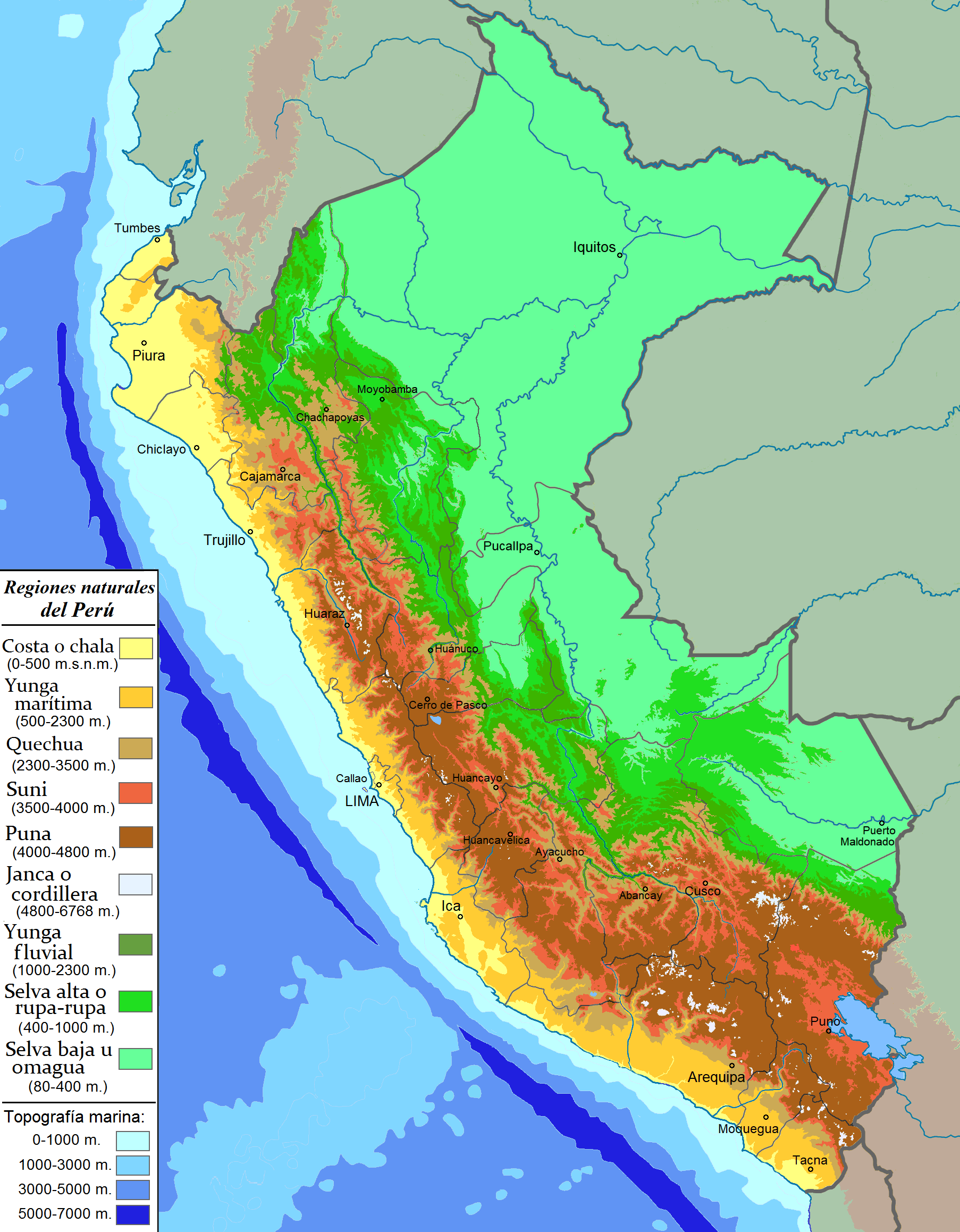
When the Spanish arrived, they divided Peru into three main regions: the coastal region (11.6% of Peru), that is bounded by the Pacific Ocean; the highlands (28.1% of Peru), that is located on the Andean Heights, and the jungle, that is located on the Amazonian Jungle (Climate of Peru). But Javier Pulgar Vidal ( es), a geographer who studied the biogeographic reality of the Peruvian territory for a long time, proposed the creation of eight Natural Regions.Pulgar Vidal, Javier: ''Geografía del Perú; Las Ocho Regiones Naturales del Perú''. Edit. Universo S.A., Lima 1979. First Edition (his dissertation of 1940): Las ocho regiones naturales del Perú, '' Boletín del Museo de Historia Natural'' „Javier Prado“, n° especial, Lima, 1941, 17, pp. 145-161. In 1941, he presented his thesis "Las Ocho Regiones Naturales del Perú" at the III General Assembly of the Pan-American Institute of Geography and History. These eight Peruvian regions are: * Chala or Coast (subtropical dry an ... [...More Info...] [...Related Items...] OR: [Wikipedia] [Google] [Baidu] |
Spanish Words And Phrases
Spanish might refer to: * Items from or related to Spain: **Spaniards are a nation and ethnic group indigenous to Spain **Spanish language, spoken in Spain and many Latin American countries **Spanish cuisine Other places * Spanish, Ontario, Canada * Spanish River (other), the name of several rivers * Spanish Town, Jamaica Other uses * John J. Spanish (1922–2019), American politician * "Spanish" (song), a single by Craig David, 2003 See also * * * Español (other) * Spain (other) * España (other) * Espanola (other) * Hispania, the Roman and Greek name for the Iberian Peninsula * Hispanic, the people, nations, and cultures that have a historical link to Spain * Hispanic (other) * Hispanism * Spain (other) * National and regional identity in Spain * Culture of Spain * Spanish Fort (other) Spanish Fort or Old Spanish Fort may refer to: United States * Spanish Fort, Alabama, a city * Spanish Fort (Color ... [...More Info...] [...Related Items...] OR: [Wikipedia] [Google] [Baidu] |
Geography Of Mesoamerica
The geography of Mesoamerica describes the geographic features of Mesoamerica, a culture area in the Americas inhabited by complex indigenous pre-Columbian cultures exhibiting a suite of shared and common cultural characteristics. Several well-known Mesoamerican cultures include the Olmec, Teotihuacan, the Maya, the Aztec and the Purépecha. Mesoamerica is often subdivided in a number of ways. One common method, albeit a broad and general classification, is to distinguish between the highlands and lowlands. Another way is to subdivide the region into sub-areas that generally correlate to either culture areas or specific physiographic regions. Geographic location Mesoamerica – meaning "middle of America" – is located in the mid-latitudes (between 10° and 22° N) of the Americas in the southern portion of North America, encompassing much of the isthmus that joins it with South America. Situated within the wider region known as Middle America, Mesoamerica extends from south ... [...More Info...] [...Related Items...] OR: [Wikipedia] [Google] [Baidu] |
Climate Of South America
The geography of South America contains many diverse regions and climates. Geographically, South America is generally considered a continent forming the southern portion of the landmass of the Americas, south and east of the Colombia–Panama border by most authorities, or south and east of the Panama Canal by some. South and North America are sometimes considered a single continent or supercontinent, while constituent regions are infrequently considered subcontinents. South America became attached to North America only recently (geologically speaking) with the formation of the Isthmus of Panama some 3 million years ago, which resulted in the Great American Interchange. The Andes, likewise a comparatively young and seismically restless mountain range, runs down the western edge of the continent; the land to the east of the northern Andes is largely tropical rainforest, the vast Amazon River basin. The continent also contains drier regions such as eastern Patagonia and the extreme ... [...More Info...] [...Related Items...] OR: [Wikipedia] [Google] [Baidu] |
Tierra Fría
In Latin America, tierra fría (Spanish for ''cold land'') are mountain locations where high elevation results in a markedly cooler climate than that encountered in the lowlands at a comparable latitude. The combination of low latitude and high altitude — typically between approximately 2,000 m (about 6,500 ft) and 3,500 m (about 11,500 ft)Zech, W. and Hintermaier-Erhard, G. (2002); Böden der Welt – Ein Bildatlas, Heidelberg, p. 98. in locations within 10° of the equator — produces a climate that falls into the same category as many oceanic climates found along the west coasts of the continents within the temperate zones — mild temperatures all year round, with monthly averages ranging from about 10°C (50°F) in the coldest months to about 18°C (64.4°F) in the warmest months (at places further poleward the range of altitudes where this climate exists becomes progressively lower). Common crops grown in the tierra fría are potatoes, wheat, barley, o ... [...More Info...] [...Related Items...] OR: [Wikipedia] [Google] [Baidu] |
Tierra Templada
Tierra templada (Spanish for ''temperate land'') is a pseudo-climatological term used in Latin America to refer to places which are either located in the tropics at a moderately high elevation or are marginally outside the astronomical tropics, producing a somewhat cooler overall climate than that found in the tropical lowlands, the zone of which is known as the tierra caliente. In countries situated close to the equator, the ''tierra templada'' typically has an elevation span of between . These thresholds become lower as the latitude increases. The Peruvian geographer Javier Pulgar Vidal used following altitudes: *1,000 m as the border between the tropical rainforest and the subtropical cloud forest *2,300 m as the end of the subtropical cloud forest ('' Yunga fluvial'') *3,500 m as the treeline *4,800 m as the puna end ''Tierra templada'' has mean average temperature between . Coffee is grown extensively as a cash crop, with grains such as wheat and corn being cultivated for subs ... [...More Info...] [...Related Items...] OR: [Wikipedia] [Google] [Baidu] |
Tierra Caliente
''Tierra caliente'' is an informal term used in Latin America to refer to places with a distinctly tropical climate. These are usually regions from sea level from 0–3,000 feet.Zech, W. and Hintermaier-Erhard, G. (2002); Böden der Welt – Ein Bildatlas, Heidelberg, p. 98. The Peruvian geographer Javier Pulgar Vidal used the altitude of 1,000 m as the border between the tropical rain forest and the subtropical cloud forest ('' Yunga fluvial'').Pulgar Vidal, Javier: Geografía del Perú; Las Ocho Regiones Naturales del Perú. Edit. Universo S.A., Lima 1979. First Edition (his dissertation of 1940): Las ocho regiones naturales del Perú, ''Boletín del Museo de historia natural "Javier Prado"'', n° especial, Lima, 1941, 17, pp. 145-161. Most tierra caliente regions are along coastal plains, but some interior basin regions also fit the label. Agriculture in those areas is dominated tropical crops, such as bananas and sugar cane. See also * Köppen climate classification * Altit ... [...More Info...] [...Related Items...] OR: [Wikipedia] [Google] [Baidu] |
Köppen Climate Classification
The Köppen climate classification is one of the most widely used climate classification systems. It was first published by German-Russian climatologist Wladimir Köppen (1846–1940) in 1884, with several later modifications by Köppen, notably in 1918 and 1936. Later, the climatologist Rudolf Geiger (1894–1981) introduced some changes to the classification system, which is thus sometimes called the Köppen–Geiger climate classification system. The Köppen climate classification divides climates into five main climate groups, with each group being divided based on seasonal precipitation and temperature patterns. The five main groups are ''A'' (tropical), ''B'' (arid), ''C'' (temperate), ''D'' (continental), and ''E'' (polar). Each group and subgroup is represented by a letter. All climates are assigned a main group (the first letter). All climates except for those in the ''E'' group are assigned a seasonal precipitation subgroup (the second letter). For example, ''Af'' indi ... [...More Info...] [...Related Items...] OR: [Wikipedia] [Google] [Baidu] |
Montane Grasslands And Shrublands
Montane grasslands and shrublands is a biome defined by the World Wildlife Fund. The biome includes high elevation grasslands and shrublands around the world. The term "montane" in the name of the biome refers to "high elevation", rather than the ecological term which denotes the region below treeline. This biome includes high elevation (montane and alpine) grasslands and shrublands, including the puna and páramo in South America, subalpine heath in New Guinea and East Africa, steppes of the Tibetan plateaus, as well as other similar subalpine habitats around the world. The plants and animals of tropical montane páramos display striking adaptations to cool, wet conditions and intense sunlight. Around the world, characteristic plants of these habitats display features such as rosette structures, waxy surfaces, and abundant pilosity. The páramos of the northern Andes are the most extensive examples of this habitat type. Although ecoregion biotas are most diverse in the And ... [...More Info...] [...Related Items...] OR: [Wikipedia] [Google] [Baidu] |
Yungas
The Yungas (Aymara ''yunka'' warm or temperate Andes or earth, Quechua ''yunka'' warm area on the slopes of the Andes) is a bioregion of a narrow band of forest along the eastern slope of the Andes Mountains from Peru and Bolivia, and extends into Northwest Argentina at the slope of the Andes pre-cordillera. It is a transitional zone between the Andean highlands and the eastern forests. Like the surrounding areas, the Yungas belong to the Neotropical realm; the climate is rainy, humid, and warm. Setting The Yungas forests are extremely diverse, ranging from moist lowland forest to evergreen montane forest and cloud forests. The terrain, formed by valleys, fluvial mountain trails and streams, is extremely rugged and varied, contributing to the ecological diversity and richness. A complex mosaic of habitats occur with changing latitude as well as elevation. There are high levels of biodiversity and species endemism throughout the Yungas regions. Many of the forests are evergreen, ... [...More Info...] [...Related Items...] OR: [Wikipedia] [Google] [Baidu] |
.jpg)


