|
Tipping Point (climatology)
In Climatology, climate science, a tipping point is a critical threshold that, when crossed, leads to large and often irreversible changes in the climate system. If tipping points are crossed, they are likely to have severe impacts on human society. Tipping behaviour is found across the climate system, in ecosystems, ice sheets, and the circulation of the ocean and atmosphere. Tipping points are often, but not necessarily, abrupt. For example, with average global warming somewhere between 0.8 and 3 °C, the Greenland ice sheet passes a tipping point and is doomed, but the melt would take place over millennia. Tipping points are possible at today's global warming of just over 1 °C above preindustrial times, and highly probable above 2 °C of global warming. The Geologic record, geological record shows many abrupt changes that suggest tipping points may have been crossed in ancient times. It is possible that some tipping points are close to being crossed or have ... [...More Info...] [...Related Items...] OR: [Wikipedia] [Google] [Baidu] |
Special Report On The Ocean And Cryosphere In A Changing Climate
The United Nations' Intergovernmental Panel on Climate Change's (IPCC) Special Report on the Ocean and Cryosphere in a Changing Climate (SROCC) is a report about the effects of climate change on the world's seas, sea ice, icecaps and glaciers. It was approved at the IPCC's 51st Session (IPCC-51) in September 2019 in Monaco. The SROCC's approved Summary for Policymakers (SPM) was released on 25 September 2019. The 1,300-page report by 104 authors and editors representing 36 countries referred to 6,981 publications. The report is the third in the series of three Special Reports in the current Sixth Assessment Report (AR6) cycle, which began in 2015 and will be completed in 2022. The first was the Special Report on Global Warming of 1.5 °C, while the second was the Special Report on Climate Change and Land (SRCCL), also known as the "Special Report on climate change, desertification, land degradation, sustainable land management, food security, and greenhouse gas fluxes in t ... [...More Info...] [...Related Items...] OR: [Wikipedia] [Google] [Baidu] |
Mean Regional Trends In Ice Thickness And Front Position
There are several kinds of mean in mathematics, especially in statistics. Each mean serves to summarize a given group of data, often to better understand the overall value (magnitude and sign) of a given data set. For a data set, the ''arithmetic mean'', also known as "arithmetic average", is a measure of central tendency of a finite set of numbers: specifically, the sum of the values divided by the number of values. The arithmetic mean of a set of numbers ''x''1, ''x''2, ..., x''n'' is typically denoted using an overhead bar, \bar. If the data set were based on a series of observations obtained by sampling from a statistical population, the arithmetic mean is the ''sample mean'' (\bar) to distinguish it from the mean, or expected value, of the underlying distribution, the ''population mean'' (denoted \mu or \mu_x).Underhill, L.G.; Bradfield d. (1998) ''Introstat'', Juta and Company Ltd.p. 181/ref> Outside probability and statistics, a wide range of other notions of mean are o ... [...More Info...] [...Related Items...] OR: [Wikipedia] [Google] [Baidu] |
Albedo
Albedo (; ) is the measure of the diffuse reflection of sunlight, solar radiation out of the total solar radiation and measured on a scale from 0, corresponding to a black body that absorbs all incident radiation, to 1, corresponding to a body that reflects all incident radiation. Surface albedo is defined as the ratio of Radiosity (radiometry), radiosity ''J''e to the irradiance ''E''e (flux per unit area) received by a surface. The proportion reflected is not only determined by properties of the surface itself, but also by the spectral and angular distribution of solar radiation reaching the Earth's surface. These factors vary with atmospheric composition, geographic location, and time (see position of the Sun). While bi-hemispherical reflectance is calculated for a single angle of incidence (i.e., for a given position of the Sun), albedo is the directional integration of reflectance over all solar angles in a given period. The temporal resolution may range from seconds (as ob ... [...More Info...] [...Related Items...] OR: [Wikipedia] [Google] [Baidu] |
Subpolar Gyre
In oceanography, a gyre () is any large system of circulating ocean currents, particularly those involved with large wind movements. Gyres are caused by the Coriolis effect; planetary vorticity, horizontal friction and vertical friction determine the circulatory patterns from the ''wind stress curl'' (torque). ''Gyre'' can refer to any type of vortex in an atmosphere or a sea, even one that is human-created, but it is most commonly used in terrestrial oceanography to refer to the major ocean systems. Major gyres The following are the five most notable ocean gyres:The five most notable gyres PowerPoint Presentation * * ... [...More Info...] [...Related Items...] OR: [Wikipedia] [Google] [Baidu] |
The Guardian
''The Guardian'' is a British daily newspaper. It was founded in 1821 as ''The Manchester Guardian'', and changed its name in 1959. Along with its sister papers ''The Observer'' and ''The Guardian Weekly'', ''The Guardian'' is part of the Guardian Media Group, owned by the Scott Trust. The trust was created in 1936 to "secure the financial and editorial independence of ''The Guardian'' in perpetuity and to safeguard the journalistic freedom and liberal values of ''The Guardian'' free from commercial or political interference". The trust was converted into a limited company in 2008, with a constitution written so as to maintain for ''The Guardian'' the same protections as were built into the structure of the Scott Trust by its creators. Profits are reinvested in journalism rather than distributed to owners or shareholders. It is considered a newspaper of record in the UK. The editor-in-chief Katharine Viner succeeded Alan Rusbridger in 2015. Since 2018, the paper's main news ... [...More Info...] [...Related Items...] OR: [Wikipedia] [Google] [Baidu] |
African Humid Period
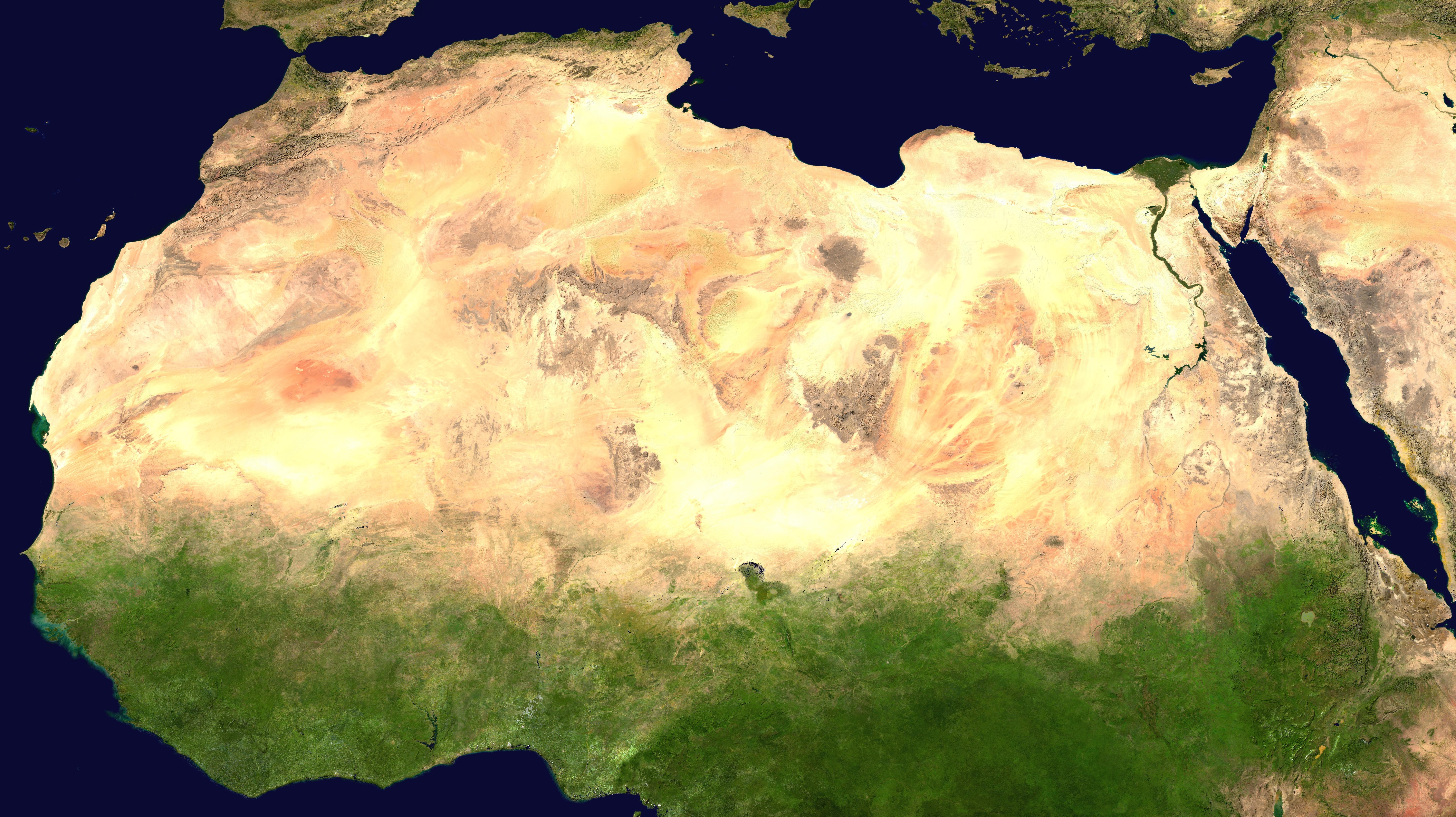
The African humid period (AHP) (also known by other names) is a climate period in Africa during the late Pleistocene and Holocene geologic epochs, when northern Africa was wetter than today. The covering of much of the Sahara desert by grasses, trees and lakes was caused by changes in Earth's orbit around the Sun; changes in vegetation and dust in the Sahara which strengthened the African monsoon; and increased greenhouse gases. During the preceding Last Glacial Maximum, the Sahara contained extensive dune fields and was mostly uninhabited. It was much larger than today, but its lakes and rivers such as Lake Victoria and the White Nile were either dry or at low levels. The humid period began about 14,600–14,500 years ago at the end of Heinrich event 1, simultaneously to the Bølling–Allerød warming. Rivers and lakes such as Lake Chad formed or expanded, glaciers grew on Mount Kilimanjaro and the Sahara retreated. Two major dry fluctuations occurred; during the Youn ... [...More Info...] [...Related Items...] OR: [Wikipedia] [Google] [Baidu] |
North African Monsoon
North African climate cycles have a unique history that can be traced back millions of years. The cyclic climate pattern of the Sahara is characterized by significant shifts in the strength of the North African Monsoon. When the North African Monsoon is at its strongest, annual precipitation and consequently vegetation in the Sahara region increase, resulting in conditions commonly referred to as the " green Sahara". For a relatively weak North African Monsoon, the opposite is true, with decreased annual precipitation and less vegetation resulting in a phase of the Sahara climate cycle known as the "desert Sahara". Variations in the climate of the Sahara region can, at the simplest level, be attributed to the changes in insolation because of slow shifts in Earth's orbital parameters. The parameters include the precession of the equinoxes, obliquity, and eccentricity as put forth by the Milankovitch theory. The precession of the equinoxes is regarded as the most important orbital para ... [...More Info...] [...Related Items...] OR: [Wikipedia] [Google] [Baidu] |
Early Holocene Sea Level Rise
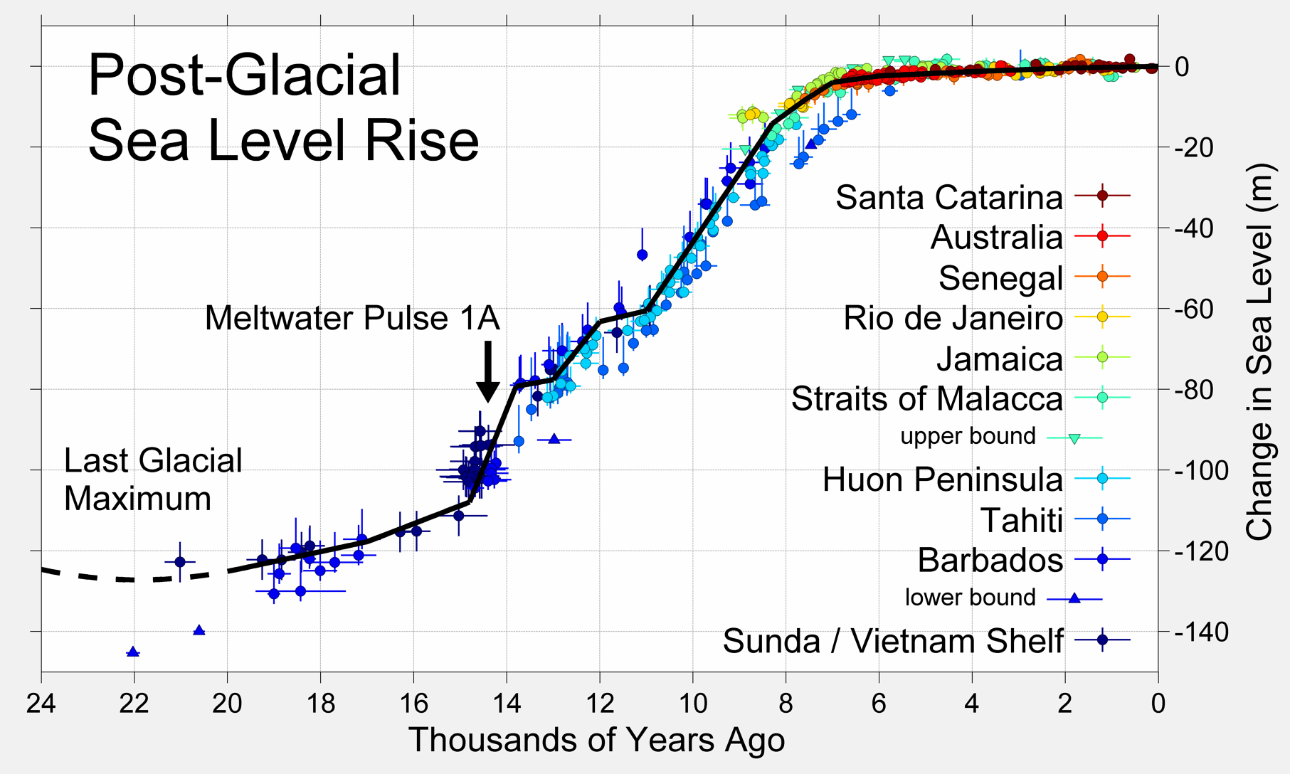
The early Holocene sea level rise (EHSLR) was a significant jump in sea level by about during the early Holocene, between about 12,000 and 7,000 years ago, spanning the Eurasian Mesolithic. The rapid rise in sea level and associated climate change, notably the 8.2 ka cooling event (8,200 years ago), and the loss of coastal land favoured by early farmers, may have contributed to the spread of the Neolithic Revolution to Europe in its Neolithic period. During deglaciation since the Last Glacial Maximum, between about 20,000 to 7,000 years ago (20–7 ka), the sea level rose by a total of about , at times at extremely high rates, due to the rapid melting of the British-Irish Sea, Fennoscandian, Laurentide, Barents-Kara, Patagonian, Innuitian and parts of the Antarctic ice sheets. At the onset of deglaciation about 19,000 years ago, a brief, at most 500-year long, glacio-eustatic event may have contributed as much as to sea level with an average rate of about /yr ... [...More Info...] [...Related Items...] OR: [Wikipedia] [Google] [Baidu] |
Past Sea Level
Global or eustatic sea level has fluctuated significantly over Earth's history. The main factors affecting sea level are the amount and volume of available water and the shape and volume of the ocean basins. The primary influences on water volume are the temperature of the seawater, which affects density, and the amounts of water retained in other reservoirs like rivers, aquifers, lakes, glaciers, polar ice caps and sea ice. Over geological timescales, changes in the shape of the oceanic basins and in land/sea distribution affect sea level. In addition to eustatic changes, local changes in sea level are caused by tectonic uplift and subsidence. Over geologic time sea level has fluctuated by more than 300 metres, possibly more than 400 metres. The main reasons for sea level fluctuations in the last 15 million years are the Antarctic ice sheet and Antarctic post-glacial rebound during warm periods. The current sea level is about 130 metres higher than the historical minimum. ... [...More Info...] [...Related Items...] OR: [Wikipedia] [Google] [Baidu] |
Holocene
The Holocene ( ) is the current geological epoch. It began approximately 11,650 cal years Before Present (), after the Last Glacial Period, which concluded with the Holocene glacial retreat. The Holocene and the preceding Pleistocene together form the Quaternary period. The Holocene has been identified with the current warm period, known as MIS 1. It is considered by some to be an interglacial period within the Pleistocene Epoch, called the Flandrian interglacial.Oxford University Press – Why Geography Matters: More Than Ever (book) – "Holocene Humanity" section https://books.google.com/books?id=7P0_sWIcBNsC The Holocene corresponds with the rapid proliferation, growth and impacts of the human species worldwide, including all of its written history, technological revolutions, development of major civilizations, and overall significant transition towards urban living in the present. The human impact on modern-era Earth and its ecosystems may be considered of global si ... [...More Info...] [...Related Items...] OR: [Wikipedia] [Google] [Baidu] |
Deglaciation
Deglaciation is the transition from full glacial conditions during ice ages, to warm interglacials, characterized by global warming and sea level rise due to change in continental ice volume. Thus, it refers to the retreat of a glacier, an ice sheet or frozen surface layer, and the resulting exposure of the Earth's surface. The decline of the cryosphere due to ablation can occur on any scale from global to localized to a particular glacier. After the Last Glacial Maximum (ca. 21,000 years ago), the last deglaciation begun, which lasted until the early Holocene. Around much of Earth, deglaciation during the last 100 years has been accelerating as a result of climate change, partly brought on by anthropogenic changes to greenhouse gases. The previous deglaciation took place from approximately 22 ka until 11.5 ka. This occurred when there was an annual mean atmospheric temperature on the earth that increased by roughly 5 °C, which was also accompanied by regional hi ... [...More Info...] [...Related Items...] OR: [Wikipedia] [Google] [Baidu] |


