|
African Humid Period
The African humid period (AHP) (also known by other names) is a climate period in Africa during the late Pleistocene and Holocene geologic epochs, when northern Africa was wetter than today. The covering of much of the Sahara desert by grasses, trees and lakes was caused by changes in Earth's orbit around the Sun; changes in vegetation and dust in the Sahara which strengthened the African monsoon; and increased greenhouse gases. During the preceding Last Glacial Maximum, the Sahara contained extensive dune fields and was mostly uninhabited. It was much larger than today, but its lakes and rivers such as Lake Victoria and the White Nile were either dry or at low levels. The humid period began about 14,600–14,500 years ago at the end of Heinrich event 1, simultaneously to the Bølling–Allerød warming. Rivers and lakes such as Lake Chad formed or expanded, glaciers grew on Mount Kilimanjaro and the Sahara retreated. Two major dry fluctuations occurred; during the Younge ... [...More Info...] [...Related Items...] OR: [Wikipedia] [Google] [Baidu] |
Sahara Satellite Hires
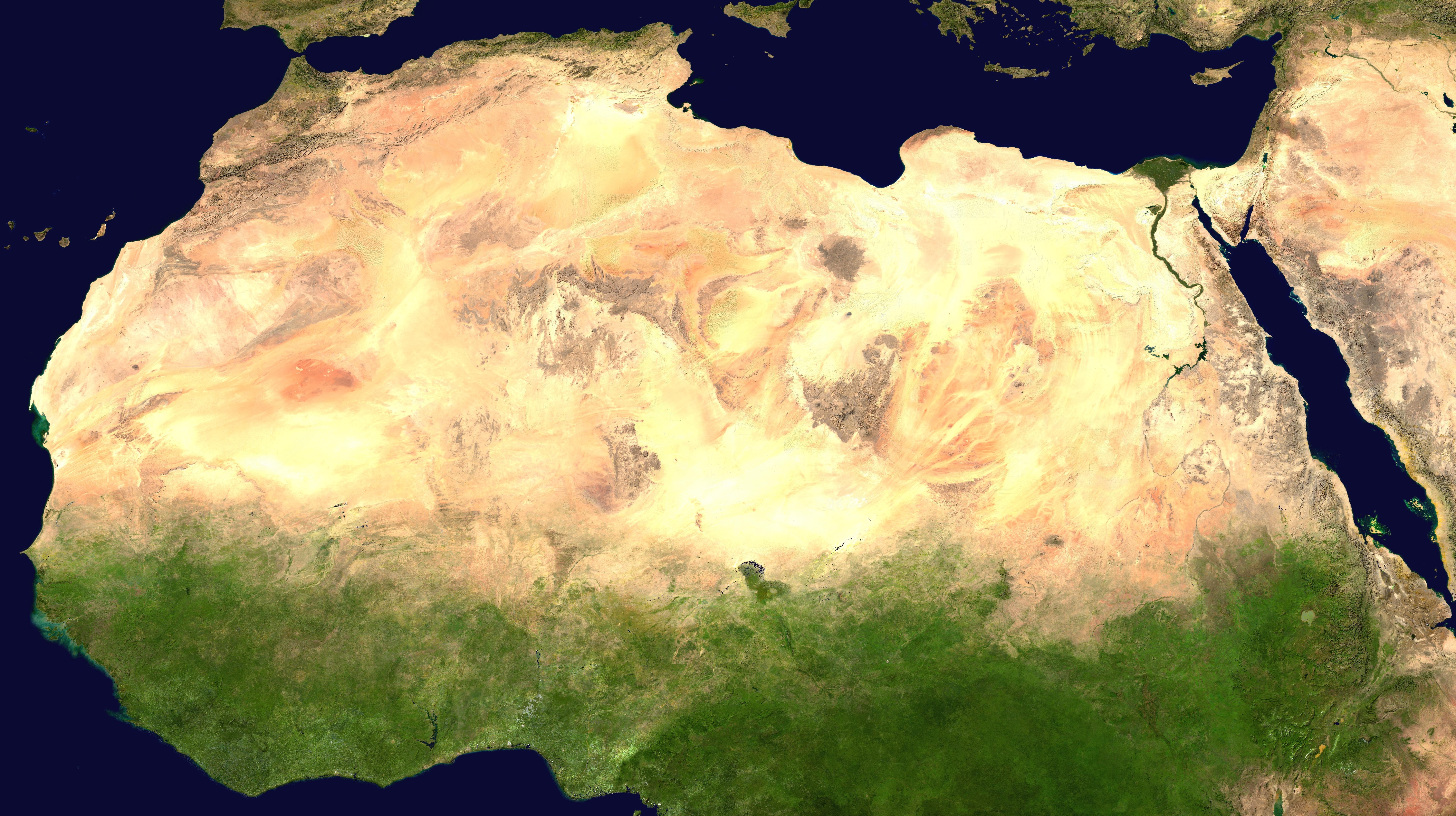
, photo = Sahara real color.jpg , photo_caption = The Sahara taken by Apollo 17 astronauts, 1972 , map = , map_image = , location = , country = , country1 = , country2 = , country3 = , country4 = , country5 = , country6 = , country7 = , country8 = , country9 = , country10 = ( disputed) , region = , state = , district = , city = , relief = , label = , label_position = , coordinates = , coordinates_ref = , elevation = , elevation_m = , elevation_ft = , elevation_ref = , length = , length_mi = , length_km = 4,800 , length_orientation = , length_note = , width = , width_mi = , widt ... [...More Info...] [...Related Items...] OR: [Wikipedia] [Google] [Baidu] |
Younger Dryas
The Younger Dryas (c. 12,900 to 11,700 years BP) was a return to glacial conditions which temporarily reversed the gradual climatic warming after the Last Glacial Maximum (LGM, c. 27,000 to 20,000 years BP). The Younger Dryas was the last stage of the Pleistocene epoch (c. 2,580,000 to 11,700 years BP) and it preceded the current, warmer Holocene epoch. The Younger Dryas was the most severe and long lasting of several interruptions to the warming of the Earth's climate, and it was preceded by the Late Glacial Interstadial (c. 14,670 to 12,900 BP). The change was relatively sudden, taking place in decades, and it resulted in a decline of temperatures in Greenland by 4~10 °C (7.2~18 °F), and advances of glaciers and drier conditions over much of the temperate Northern Hemisphere. A number of theories have been put forward about the cause, and the most widely supported by scientists is that the Atlantic meridional overturning circulation, which transports warm water ... [...More Info...] [...Related Items...] OR: [Wikipedia] [Google] [Baidu] |
Before Christ
The terms (AD) and before Christ (BC) are used to label or number years in the Julian and Gregorian calendars. The term is Medieval Latin and means 'in the year of the Lord', but is often presented using "our Lord" instead of "the Lord", taken from the full original phrase "''anno Domini nostri Jesu Christi''", which translates to 'in the year of our Lord Jesus Christ'. The form "BC" is specific to English and equivalent abbreviations are used in other languages: the Latin form is but is rarely seen. This calendar era is based on the traditionally reckoned year of the conception or birth of Jesus, ''AD'' counting years from the start of this epoch and ''BC'' denoting years before the start of the era. There is no year zero in this scheme; thus ''the year AD 1 immediately follows the year 1 BC''. This dating system was devised in 525 by Dionysius Exiguus, but was not widely used until the 9th century. Traditionally, English follows Latin usage by placing the "A ... [...More Info...] [...Related Items...] OR: [Wikipedia] [Google] [Baidu] |
Herodotus
Herodotus ( ; grc, , }; BC) was an ancient Greek historian and geographer from the Greek city of Halicarnassus, part of the Persian Empire (now Bodrum, Turkey) and a later citizen of Thurii in modern Calabria ( Italy). He is known for having written the ''Histories'' – a detailed account of the Greco-Persian Wars. Herodotus was the first writer to perform systematic investigation of historical events. He is referred to as " The Father of History", a title conferred on him by the ancient Roman orator Cicero. The ''Histories'' primarily cover the lives of prominent kings and famous battles such as Marathon, Thermopylae, Artemisium, Salamis, Plataea, and Mycale. His work deviates from the main topics to provide a cultural, ethnographical, geographical, and historiographical background that forms an essential part of the narrative and provides readers with a wellspring of additional information. Herodotus has been criticized for his inclusion of "legends and fa ... [...More Info...] [...Related Items...] OR: [Wikipedia] [Google] [Baidu] |
Mesopotamia
Mesopotamia ''Mesopotamíā''; ar, بِلَاد ٱلرَّافِدَيْن or ; syc, ܐܪܡ ܢܗܪ̈ܝܢ, or , ) is a historical region of Western Asia situated within the Tigris–Euphrates river system, in the northern part of the Fertile Crescent. Today, Mesopotamia occupies modern Iraq. In the broader sense, the historical region included present-day Iraq and Kuwait and parts of present-day Iran, Syria and Turkey. The Sumerians and Akkadians (including Assyrian people, Assyrians and Babylonians) originating from different areas in present-day Iraq, dominated Mesopotamia from the beginning of recorded history, written history () to the fall of Babylon in 539 BC, when it was conquered by the Achaemenid Empire. It fell to Alexander the Great in 332 BC, and after his death, it became part of the Greek Seleucid Empire. Later the Arameans dominated major parts of Mesopotamia (). Mesopotamia is the site of the earliest developments of the Neolithic Revolution from aroun ... [...More Info...] [...Related Items...] OR: [Wikipedia] [Google] [Baidu] |
Nile Valley
The Nile, , Bohairic , lg, Kiira , Nobiin: Áman Dawū is a major north-flowing river in northeastern Africa. It flows into the Mediterranean Sea. The Nile is the longest river in Africa and has historically been considered the longest river in the world, though this has been contested by research suggesting that the Amazon River is slightly longer.Amazon Longer Than Nile River, Scientists Say Of the world's major rivers, the Nile is one of the smallest, as measured by annual flow in cubic metres of water. About long, its covers eleven countries: the [...More Info...] [...Related Items...] OR: [Wikipedia] [Google] [Baidu] |
Acacus Mountains
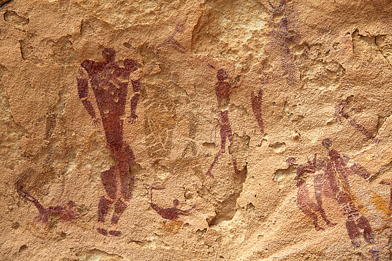
The Acacus Mountains or Tadrart Akakus ( ar, تدرارت أكاكوس / ALA-LC: ''Tadrārt Akākūs'') form a mountain range in the desert of the Ghat District in western Libya, part of the Sahara. They are situated east of the city of Ghat, Libya, and stretch north from the border with Algeria, about . The area has a particularly rich array of prehistoric rock art. History Etymology ''Tadrart'' is the feminine form of "mountain" in the Berber languages (masculine: ''adrar''). Rock art The area is known for its rock art and was inscribed as a UNESCO World Heritage Site in 1985 because of the importance of these paintings and carvings. The paintings date from 12,000 BCE to 100 CE and reflect cultural and natural changes in the area. There are paintings and carvings of animals such as giraffes, elephants, ostriches and camels, but also of humans and horses. People are depicted in various daily life situations, for example while making music and dancing. File:Tad ... [...More Info...] [...Related Items...] OR: [Wikipedia] [Google] [Baidu] |
Cave Of Swimmers
The Cave of Swimmers is a cave with ancient rock art in the mountainous Gilf Kebir plateau of the Libyan Desert section of the Sahara. It is located in the New Valley Governorate of southwest Egypt, near the border with Libya. History The cave and rock art was discovered in October 1933 by the Hungarian explorer László Almásy. It contains Neolithic pictographs (rock painting images) and is named due to the depictions of people with their limbs bent as if they were swimming. The drawings include those of giraffe and hippopotamus. They are estimated to have been created as early as 10,000 years ago with the beginning of the African Humid Period, when the Sahara was significantly greener and wetter than it is today. The cause of the climate change 10,000 years ago was due to changes in summer solar insolation and vegetation and dust feedbacks. Almásy devoted a chapter to the cave in his 1934 book, ''The Unknown Sahara''. In it he postulates that the swimming scenes are real ... [...More Info...] [...Related Items...] OR: [Wikipedia] [Google] [Baidu] |
Rock Painting
In archaeology, rock art is human-made markings placed on natural surfaces, typically vertical stone surfaces. A high proportion of surviving historic and prehistoric rock art is found in caves or partly enclosed rock shelters; this type also may be called cave art or parietal art. A global phenomenon, rock art is found in many culturally diverse regions of the world. It has been produced in many contexts throughout human history. In terms of technique, the four main groups are: * cave paintings, * petroglyphs, which are carved or scratched into the rock surface, * sculpted rock reliefs, and * geoglyphs, which are formed on the ground. The oldest known rock art dates from the Upper Palaeolithic period, having been found in Europe, Australia, Asia, and Africa. Anthropologists studying these artworks believe that they likely had magico-religious significance. The archaeological sub-discipline of rock art studies first developed in the late-19th century among Francophone scholars ... [...More Info...] [...Related Items...] OR: [Wikipedia] [Google] [Baidu] |
Dufuna Canoe
The Dufuna canoe is a dugout canoe discovered in 1987 by a Fulani cattle herdsman a few kilometers from the village of Dufuna in the Fune Local Government Area, not far from the Komadugu Gana River, in Yobe State, Nigeria. Radiocarbon dating of a sample of charcoal found near the site dates the canoe at 8,500 to 8,000 years old, linking the site to Lake Chad. The canoe is long and is tall at it largest point. It is currently located in Damaturu, Nigeria. Background The Dufuna canoe was found in the village of Dufuna, which is located between Potiskum and Gashua, in Yobe State. On 4 May 1987, Mallam Ya'u, a Fulani cow herdsman was digging a well and hit a hard object at 4.5 meters. He informed his village chief about the discovery. In 1989 and 1990, the University of Maiduguri carried out an initial exploration of the site to ascertain whether it was a canoe as well take radiocarbon dating samples of the wood. Later, in a joint research project funded by the University of F ... [...More Info...] [...Related Items...] OR: [Wikipedia] [Google] [Baidu] |
Archaeological Site
An archaeological site is a place (or group of physical sites) in which evidence of past activity is preserved (either prehistoric or historic or contemporary), and which has been, or may be, investigated using the discipline of archaeology and represents a part of the archaeological record. Sites may range from those with few or no remains visible above ground, to buildings and other structures still in use. Beyond this, the definition and geographical extent of a "site" can vary widely, depending on the period studied and the theoretical approach of the archaeologist. Geographical extent It is almost invariably difficult to delimit a site. It is sometimes taken to indicate a settlement of some sort although the archaeologist must also define the limits of human activity around the settlement. Any episode of deposition such as a hoard or burial can form a site as well. Development-led archaeology undertaken as cultural resources management has the disadvantage (or the be ... [...More Info...] [...Related Items...] OR: [Wikipedia] [Google] [Baidu] |
Hunter-gatherer
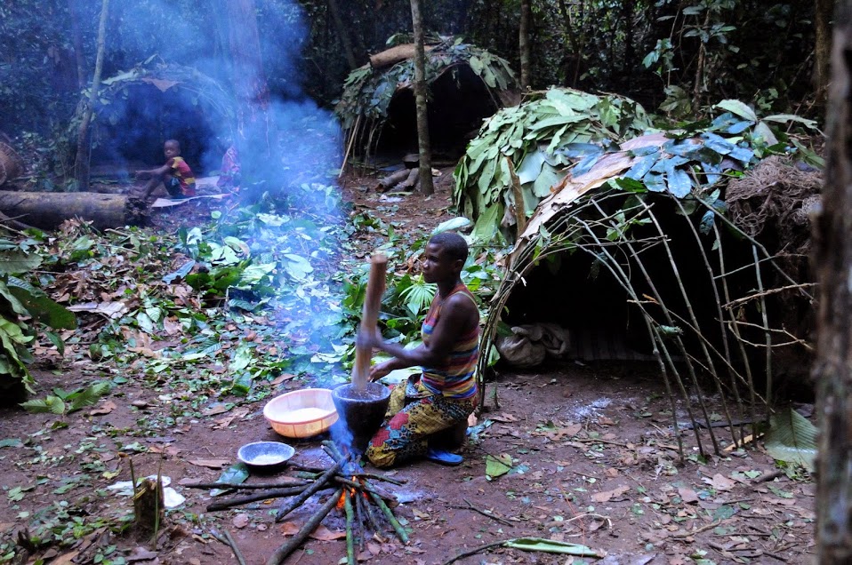
A traditional hunter-gatherer or forager is a human living an ancestrally derived lifestyle in which most or all food is obtained by foraging, that is, by gathering food from local sources, especially edible wild plants but also insects, fungi, honey, or anything safe to eat, and/or by hunting game (pursuing and/or trapping and killing wild animals, including catching fish), roughly as most animal omnivores do. Hunter-gatherer societies stand in contrast to the more sedentary agricultural societies, which rely mainly on cultivating crops and raising domesticated animals for food production, although the boundaries between the two ways of living are not completely distinct. Hunting and gathering was humanity's original and most enduring successful competitive adaptation in the natural world, occupying at least 90 percent of human history. Following the invention of agriculture, hunter-gatherers who did not change were displaced or conquered by farming or pastoralist ... [...More Info...] [...Related Items...] OR: [Wikipedia] [Google] [Baidu] |


