|
Zeiningen
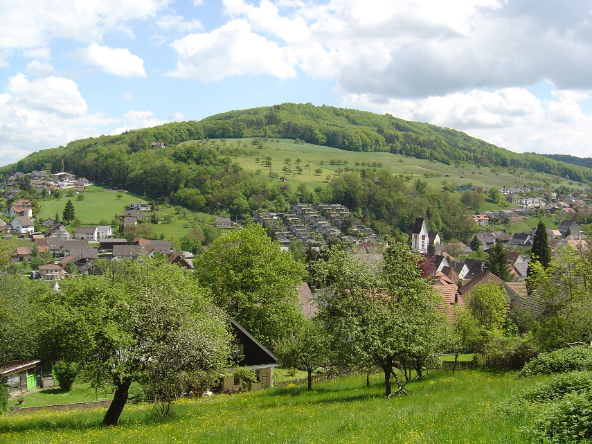
Zeiningen is a municipality in the district of Rheinfelden in the canton of Aargau in Switzerland. Geography Zeiningen has an area, , of . Of this area, or 43.9% is used for agricultural purposes, while or 44.2% is forested. Of the rest of the land, or 11.9% is settled (buildings or roads) and or 0.1% is unproductive land.Swiss Federal Statistical Office-Land Use Statistics 2009 data accessed 25 March 2010 Of the built up area, housing and buildings made up 4.1% and transportation infrastructure made up 5.5%. Power and water infrastructure as well as other special developed areas made up 1.4% of the area Out of the forested land, 42.5% of the total land area is heavily forested and 1.7% is covered with orchards or small clusters of trees. Of ... [...More Info...] [...Related Items...] OR: [Wikipedia] [Google] [Baidu] |
Zuzgen
Zuzgen (Swiss German: ) is a municipality in the Rheinfelden District of canton Aargau in Switzerland. It is located in the West of the Fricktal region, around three kilometers southwest of the border with Germany, and has a border with Canton Basel-Landschaft. Geography The village lies in the mid-reaches of the Möhlin valley ( Möhlintal) through which flows the Möhlinbach in a northwesterly direction towards the Rhine. The flat valley floor alongside the Möhlinbach is, on average, close to 200 meters wide and is bordered on both sides by the hills of the Tabel Jura ( Tafeljura) which have very steep lower slopes leading to flat upper plateau's that are intensively farmed. In the North the almost circular Chriesiberg (558m) is found and in the East lies the Lohnberg (581 m) with a hamlet of the same name. This flat plateau is around one kilometer wide and stretches for over four kilometers to the southwest (known as the Wabrig plateau above Hellikon and the Hersberg ab ... [...More Info...] [...Related Items...] OR: [Wikipedia] [Google] [Baidu] |
Ägelsee (Zeiningen)
Ägelsee (or Egelsee) is a small lake in the municipality of Zeiningen, Canton of Aargau, Switzerland ). Swiss law does not designate a ''capital'' as such, but the federal parliament and government are installed in Bern, while other federal institutions, such as the federal courts, are in other cities (Bellinzona, Lausanne, Luzern, Neuchâtel .... The 7500 m2 nature preserve is an amphibian spawning area of national importance. External links *http://www.nvzeiningen.ch Lakes of Aargau Lakes of Switzerland Protected areas of Switzerland {{Aargau-geo-stub ... [...More Info...] [...Related Items...] OR: [Wikipedia] [Google] [Baidu] |
Rheinfelden (district)
Rheinfelden District lies in the northwest of the canton of Aargau in Switzerland, in the Fricktal region. Its capital is Rheinfelden. Around 88% of the population live in the conurbation of Basel. There are 14 municipalities, with a population of (as of ) living in an area of 112.09 km2. The population density is around 355 persons per square kilometre. Geography The Rheinfelden district has an area, , of . Of this area, or 44.0% is used for agricultural purposes, while or 39.7% is forested. Of the rest of the land, or 13.4% is settled (buildings or roads). Demographics Rheinfelden district has a population () of . , 21.3% of the population are foreign nationals.Statistical Department of Canton Aargau -Bereich 01 -Bevölkerung accessed 20 January 2010 Economy there we ...[...More Info...] [...Related Items...] OR: [Wikipedia] [Google] [Baidu] |
Maisprach
Maisprach is a municipality in the district of Sissach in the canton of Basel-Country in Switzerland. History Maisprach is first mentioned in 1247 as ''Mesbache''. Geography Maisprach has an area, , of . Of this area, or 50.1% is used for agricultural purposes, while or 38.9% is forested. Of the rest of the land, or 10.1% is settled (buildings or roads).Swiss Federal Statistical Office-Land Use Statistics 2009 data accessed 25 March 2010 Of the built up area, housing and buildings made up 6.1% and transportation infrastructure made up 3.4%. Out of the forested land, 37.7% of the total land area is heavily forested and 1.2% is covered with orchards or small clusters of trees. Of the agricultural land, 16.6% is used for growing crops and 20.9% i ... [...More Info...] [...Related Items...] OR: [Wikipedia] [Google] [Baidu] |
Möhlin
Möhlin () is a municipality in the district of Rheinfelden in the canton of Aargau in Switzerland. History The area around Möhlin was prehistorically settled. A neolithic settlement has been discovered at ''Chleizelgli'', while scattered Bronze Age items were discovered around the municipality. There was a Roman era estate as well as three watchtowers along the Rhine river. During the Early to High Middle Ages it was the site of fortified refuge. The modern village of Möhlin is first mentioned in 794 as ''Melina''. In the 13th Century a knight in the service of the House of Zähringen and a 15th Century Rheinfeld '' Schultheiss'' (mayor) both had the name von Meli, which is derived from Möhlin. The municipality of Möhlin came into being when eight hamlets merged over the course of the 15th Century. Jurors (a group of men of good character that were used to investigate crimes and/or judge the accused) from Möhlin are first mentioned in 1473. From 1135 until 1797 ... [...More Info...] [...Related Items...] OR: [Wikipedia] [Google] [Baidu] |
Mumpf
Mumpf is a municipality in the district of Rheinfelden in the canton of Aargau in Switzerland. History The area around Mumpf was prehistorically settled. In 1991 a mid to late neolithic fortified settlement was excavated on the ''Kapf/Chapf'' hill. This settlement was surrounded by a huge moat, and presumably protected by palisades. Inside the settlement wooden beams, fire pits, a clay pit and numerous stone tools were found. In addition, many individual Stone and Bronze Age objects have been found throughout the municipality. An Iron Age midden heap was found at Rifeld. Below the ''Gasthaus'' (combination hotel and restaurant) Anker are the foundations of a Roman small fort from the second half of the 4th Century and a nearby soldier's grave from the same period. Between Mumpf and Stein, a fragment of a milestone, with an inscription, from the time of Antoninus Pius (139 AD) was discovered. Mumpf is first mentioned in 1218 as ''Mumpher''. In 1278 it was mentioned as '' ... [...More Info...] [...Related Items...] OR: [Wikipedia] [Google] [Baidu] |
Wallbach, Switzerland
Wallbach is a municipality in the district of Rheinfelden in the canton of Aargau in Switzerland. Geography Wallbach has an area, , of . Of this area, or 43.2% is used for agricultural purposes, while or 29.3% is forested. Of the rest of the land, or 18.0% is settled (buildings or roads), or 8.9% is either rivers or lakes.Swiss Federal Statistical Office-Land Use Statistics 2009 data accessed 25 March 2010 Of the built up area, industrial buildings made up 1.8% of the total area while housing and buildings made up 11.1% and transportation infrastructure made up 3.8%. Out of the forested land, all of the forested land area is covered with heavy forests. Of the agricultural land, 33.7% is used for growing crops and 8.4% is pastures, while 1.1% is ... [...More Info...] [...Related Items...] OR: [Wikipedia] [Google] [Baidu] |
Buus
Buus is a municipality in the district of Sissach in the canton of Basel-Country in Switzerland. History Buus is first mentioned in 1273 as ''Bus''. Geography Buus has an area, , of . Of this area, or 64.5% is used for agricultural purposes, while or 28.5% is forested. Of the rest of the land, or 7.2% is settled (buildings or roads).Swiss Federal Statistical Office-Land Use Statistics 2009 data accessed 25 March 2010 Of the built up area, housing and buildings made up 4.3% and transportation infrastructure made up 2.5%. Out of the forested land, 26.8% of the total land area is heavily forested and 1.7% is covered with orchards or small clusters of trees. Of the agricultural land, 25.5% is used for growing crops and 30.8% is pastures, while ... [...More Info...] [...Related Items...] OR: [Wikipedia] [Google] [Baidu] |
Free Democratic Party Of Switzerland
french: Parti radical-démocratique it, Partito Liberale Radicale rm, Partida liberaldemocrata svizra , logo = Free Democratic Party of Switzerland logo French.png , logo_size = 200px , foundation = , dissolution = , merged = FDP.The Liberals , headquarters = Neuengasse 20 Postfach 6136CH-3001 Bern , ideology = , position = Centre-right , international = Liberal International , european = European Liberal Democrat and Reform Party , europarl = , colours = Azure , country = Switzerland The Free Democratic Party or Radical Democratic Party (german: Freisinnig-Demokratische Partei, FDP; french: Parti radical-démocratique, PRD; it, Partito liberale-radicale svizzero, PLR; rm, Partida liberaldemocrata svizra, PLD) was a liberal political party in Switzerland. Formerly one of the major parties in Switzerland, on 1 January 2009 it merged with the Liberal ... [...More Info...] [...Related Items...] OR: [Wikipedia] [Google] [Baidu] |
Voter Turnout
In political science, voter turnout is the participation rate (often defined as those who cast a ballot) of a given election. This can be the percentage of registered voters, eligible voters, or all voting-age people. According to Stanford University political scientists Adam Bonica and Michael McFaul, there is a consensus among political scientists that "democracies perform better when more people vote." Institutional factors drive the vast majority of differences in turnout rates.Michael McDonald and Samuel Popkin"The Myth of the Vanishing Voter"in American Political Science Review. December 2001. p. 970. For example, simpler parliamentary democracies where voters get shorter ballots, fewer elections, and a multi-party system that makes accountability easier see much higher turnout than the systems of the United States, Japan, and Switzerland. Significance Some parts of society are more likely to vote than others. As turnout approaches 90%, significant differences between vot ... [...More Info...] [...Related Items...] OR: [Wikipedia] [Google] [Baidu] |


