|
Zantman's Rock
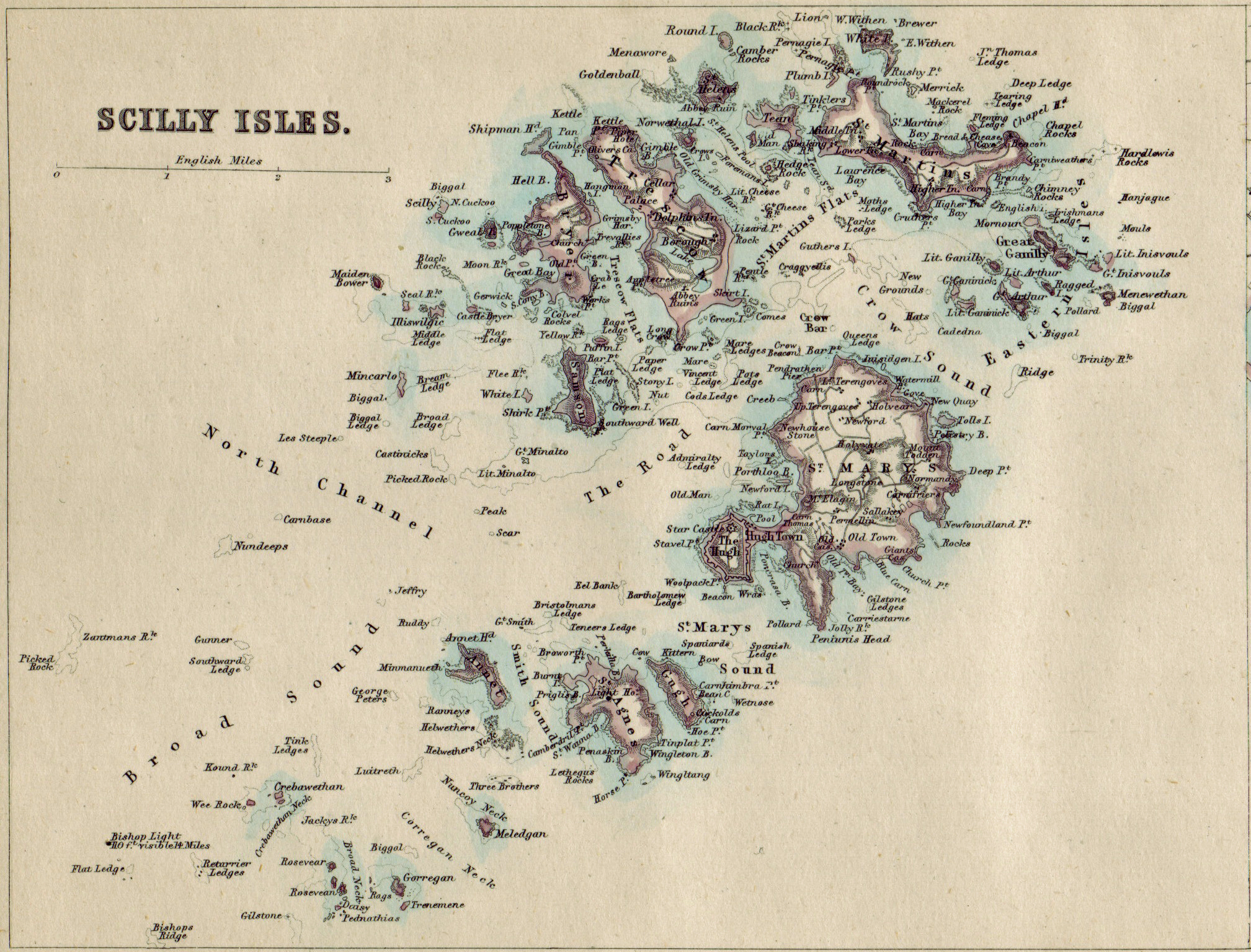
Zantman's Rock is located to the west of Land's End, Cornwall, and west from the Isles of Scilly. Viewed from a distance, it is barely visible on the surface of the waters. It is north of Bishop Rock Lighthouse, and about northeast of the Crim Rocks. The name "Zantman's Rock" is recorded on an Admiralty chart of 1860: before then, it appears not to have been distinguished from the Crim Rocks a short distance to the southwest.Dixe Wills, (2005), ''The Z-Z of Great Britain'', page 35. Icon. Several legends attempt to explain the name of the rock, one of which involves a Dutchman being shipwrecked and finding himself in the unlikely position of clinging on to the rock. Zantman's Rock has been the cause of at least one famous shipwreck: that of the ''Susanna'', on 14 August 1913. The wreckage still lies on the southwestern side of Zantman's Rock. See also *List of shipwrecks of the Isles of Scilly The list of shipwrecks of the Isles of Scilly is a list of ships which s ... [...More Info...] [...Related Items...] OR: [Wikipedia] [Google] [Baidu] |
Isles Of Scilly
The Isles of Scilly (; kw, Syllan, ', or ) is an archipelago off the southwestern tip of Cornwall, England. One of the islands, St Agnes, is the most southerly point in Britain, being over further south than the most southerly point of the British mainland at Lizard Point. The total population of the islands at the 2011 United Kingdom census was 2,203. Scilly forms part of the ceremonial county of Cornwall, and some services are combined with those of Cornwall. However, since 1890, the islands have had a separate local authority. Since the passing of the Isles of Scilly Order 1930, this authority has had the status of a county council and today is known as the Council of the Isles of Scilly. The adjective "Scillonian" is sometimes used for people or things related to the archipelago. The Duchy of Cornwall owns most of the freehold land on the islands. Tourism is a major part of the local economy, along with agriculture—particularly the production of cut flowers. ... [...More Info...] [...Related Items...] OR: [Wikipedia] [Google] [Baidu] |
Civil Parishes In England
In England, a civil parish is a type of Parish (administrative division), administrative parish used for Local government in England, local government. It is a territorial designation which is the lowest tier of local government below districts of England, districts and metropolitan and non-metropolitan counties of England, counties, or their combined form, the Unitary authorities of England, unitary authority. Civil parishes can trace their origin to the ancient system of Parish (Church of England), ecclesiastical parishes, which historically played a role in both secular and religious administration. Civil and religious parishes were formally differentiated in the 19th century and are now entirely separate. Civil parishes in their modern form came into being through the Local Government Act 1894, which established elected Parish councils in England, parish councils to take on the secular functions of the vestry, parish vestry. A civil parish can range in size from a sparsely ... [...More Info...] [...Related Items...] OR: [Wikipedia] [Google] [Baidu] |
Bryher, Isles Of Scilly
Bryher ( kw, Breyer "place of hills") is one of the smallest inhabited islands of the Isles of Scilly, with a population of 84 in 2011, spread across . History The name of the island is recorded as ''Brayer'' in 1336 and ''Brear'' in 1500. Geography The island is a procession of prominent hills all joined to one another by low-lying necks and sandy bars. It would only need sea levels to rise by a few metres for the southern part of Bryher to transform itself into a group of five or six separate islands. As all these hills – Gweal, Timmy's, Watch, Heathy and Samson – are too exposed and windswept to be cultivated and Bryher's ninety residents have to make their lives in a relatively narrow zone between hill and shore. The island has a length of , a maximum width of and an area of , including Shipman Head, which rises to at the northern end of the island. Bryher lies to the west of Tresco, and is separated from that island by the Tresco Channel, once the main anchorage fo ... [...More Info...] [...Related Items...] OR: [Wikipedia] [Google] [Baidu] |
Land's End
Land's End ( kw, Penn an Wlas or ''Pedn an Wlas'') is a headland and tourist and holiday complex in western Cornwall, England, on the Penwith peninsula about west-south-west of Penzance at the western end of the A30 road. To the east of it is the English Channel, and to the west the Celtic Sea. Land's End is the most westerly point of mainland England. However, it is not the westernmost point on mainland Great Britain, as this title narrowly goes to Corrachadh Mòr in the Scottish Highlands. Geography The actual Land's End, or Peal Point, is a modest headland compared with nearby headlands such as Pedn-men-dhu overlooking Sennen Cove and Pordenack, to the south. The present hotel and tourist complex is at Carn Kez, south of the actual Land's End. Land's End has a particular resonance because it is often used to suggest distance. Land's End to John o' Groats in Scotland is a distance of by road and this ''Land's End to John o' Groats'' distance is often used to define chari ... [...More Info...] [...Related Items...] OR: [Wikipedia] [Google] [Baidu] |
Cornwall
Cornwall (; kw, Kernow ) is a historic county and ceremonial county in South West England. It is recognised as one of the Celtic nations, and is the homeland of the Cornish people. Cornwall is bordered to the north and west by the Atlantic Ocean, to the south by the English Channel, and to the east by the county of Devon, with the River Tamar forming the border between them. Cornwall forms the westernmost part of the South West Peninsula of the island of Great Britain. The southwesternmost point is Land's End and the southernmost Lizard Point. Cornwall has a population of and an area of . The county has been administered since 2009 by the unitary authority, Cornwall Council. The ceremonial county of Cornwall also includes the Isles of Scilly, which are administered separately. The administrative centre of Cornwall is Truro, its only city. Cornwall was formerly a Brythonic kingdom and subsequently a royal duchy. It is the cultural and ethnic origin of the Cornish dias ... [...More Info...] [...Related Items...] OR: [Wikipedia] [Google] [Baidu] |
Bishop Rock, Isles Of Scilly
The Bishop Rock ( kw, Men Epskop) is a skerry off the Great Britain, British coast in the northern Atlantic Ocean known for its lighthouse. It is in the westernmost part of the Isles of Scilly, an archipelago off the southwestern tip of the Cornwall, Cornish peninsula of Great Britain. The ''Guinness Book of Records'' lists it as the world's smallest island with a building on it. The original iron lighthouse was begun in 1847 but was washed away before it could be completed. The present building was completed in 1858 and was first lit on 1September that year. Before the installation of the helipad, visitors to the lighthouse would rappel from the top (with winches installed at the lamp level and at the base below) to boats waiting away from the lighthouse. Bishop Rock is also at the eastern end of the North Atlantic shipping route used by ocean liners in the first half of the 20th century; the western end being the entrance to Lower New York Bay. This was the route that ocean ... [...More Info...] [...Related Items...] OR: [Wikipedia] [Google] [Baidu] |
Crim Rocks
Crim Rocks ( kw, Kribyn "little reef") is a small group of uninhabited islands in the Isles of Scilly, England, United Kingdom. The Crim Rocks are the most westward of the archipelago's Western Rocks, Andrew Breeze, (2007), ''Cornish toponyms: Crim Rocks, Darite, Perranuthnoe, Port Isaac, and Treverva''. Celtica Vol. 25, page 2 therefore making them the westernmost point of England. They are approximately north of Bishop Rock,Great Britain, Hydrographic Dept, (1891), ''Sailing directions for the west coast of England'', page 26 and about southwest of Zantman's Rock. The name may be cognate with the Middle Welsh "crimp" meaning "shin, ridge, or ledge." The most conspicuous of the Crim Rocks is the Peaked Rock. At least thirty ships are known to have been wrecked on the Crims. See also *List of shipwrecks of the Isles of Scilly *List of extreme points of the United Kingdom This is a list of the extreme points of the United Kingdom: the points that are farther north, south ... [...More Info...] [...Related Items...] OR: [Wikipedia] [Google] [Baidu] |
Dutch People
The Dutch (Dutch: ) are an ethnic group and nation native to the Netherlands. They share a common history and culture and speak the Dutch language. Dutch people and their descendants are found in migrant communities worldwide, notably in Aruba, Suriname, Guyana, Curaçao, Argentina, Brazil, Canada,Based on Statistics Canada, Canada 2001 Censusbr>Linkto Canadian statistics. Australia, South Africa, New Zealand and the United States.According tFactfinder.census.gov The Low Countries were situated around the border of France and the Holy Roman Empire, forming a part of their respective peripheries and the various territories of which they consisted had become virtually autonomous by the 13th century. Under the Habsburgs, the Netherlands were organised into a single administrative unit, and in the 16th and 17th centuries the Northern Netherlands gained independence from Spain as the Dutch Republic. The high degree of urbanization characteristic of Dutch society was attained at a ... [...More Info...] [...Related Items...] OR: [Wikipedia] [Google] [Baidu] |
Shipwreck
A shipwreck is the wreckage of a ship that is located either beached on land or sunken to the bottom of a body of water. Shipwrecking may be intentional or unintentional. Angela Croome reported in January 1999 that there were approximately three million shipwrecks worldwide (an estimate rapidly endorsed by UNESCO and other organizations). When a ship's crew has died or abandoned the ship, and the ship has remained adrift but unsunk, they are instead referred to as ghost ships. Types Historic wrecks are attractive to maritime archaeologists because they preserve historical information: for example, studying the wreck of revealed information about seafaring, warfare, and life in the 16th century. Military wrecks, caused by a skirmish at sea, are studied to find details about the historic event; they reveal much about the battle that occurred. Discoveries of treasure ships, often from the period of European colonisation, which sank in remote locations leaving few livin ... [...More Info...] [...Related Items...] OR: [Wikipedia] [Google] [Baidu] |
List Of Shipwrecks Of The Isles Of Scilly
The list of shipwrecks of the Isles of Scilly is a list of ships which sank on or near the Isles of Scilly. The list includes ships that sustained a damaged hull, which were later refloated and repaired. Before 1601 1305 * an unnamed sailing vessel wrecked on Tresco. The Coroner, William le Poer, on the island to take charge of the salvaged cargo, was ″seized by the mob″ led by Randulph de Blancminster, Lord of the Manor, and imprisoned until he was able to purchase his freedom. 1555 * unidentified Spanish or Spanish–Netherlands vessel on Bartholomew Ledge. The oldest wreck site in the Isles of Scilly protected under the Protection of Wrecks Act 1973. 1597 * February – the Spanish Fleet of Indies galleon ''San Bartolomé'' () was lost within the Isles of Scilly. She was carrying lead ingots and fragments of bronze bells. (Note: may refer to 1555 wreck above.) 1601–1700 1616 or 1617 * a ship () equipped by Sir Walter Raleigh at his own expense sank in a gale ... [...More Info...] [...Related Items...] OR: [Wikipedia] [Google] [Baidu] |


