|
Yongho-dong, Busan
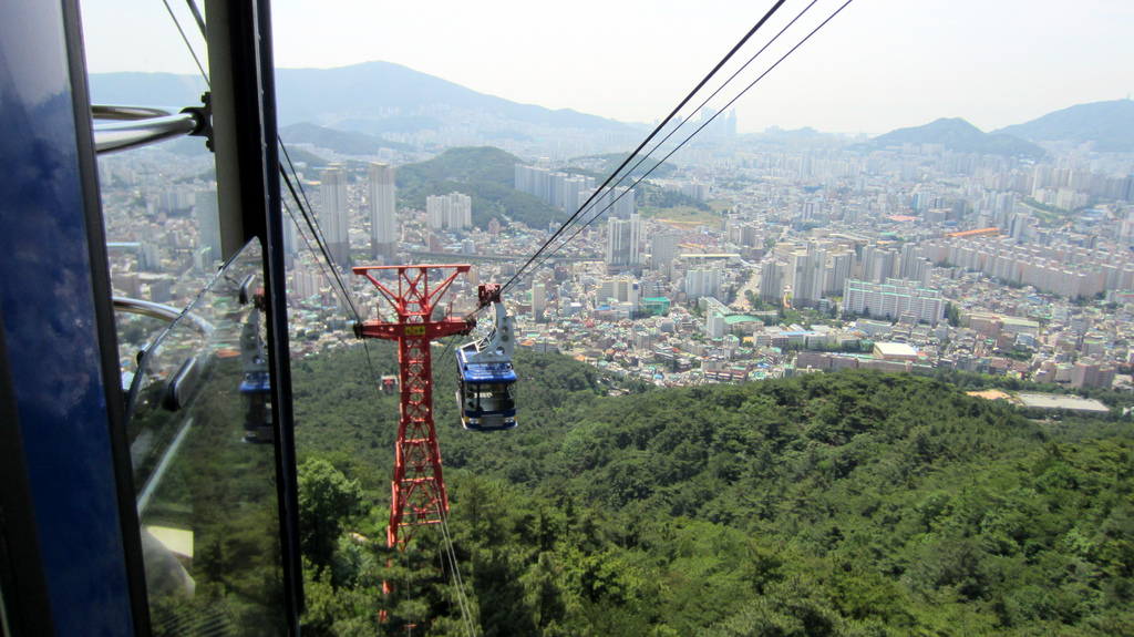
Yongho-dong is a '' dong'' on the coast of Busan, a major port city in southeastern South Korea. Its mainland portion is bordered on three sides by water, standing on a peninsula which separates Busan Harbor from Suyeong Bay. Its boundaries include the famed islets of Oryukdo, and several other small uninhabited islands. Yongho-dong is a legal ''dong''; for administrative purposes, it is divided into four administrative ''dong'': Yongho 1,2,3, and 4-dong. Yongho 1-dong alone, with more than 43,000 people, is the most heavily populated administrative dong in Nam-gu. Yongho-dong is densely populated; its 7 square kilometers of land are home to more than 72,000 people. Thanks to its proximity to the harbor, it is also the site of a campus of the Korea Institute of Maritime and Fisheries Technology. There are varying accounts of the origin of the name "Yongho," which dates to the Japanese occupation. The second syllable ''ho'' means lake, and refers to a salt pan which once ... [...More Info...] [...Related Items...] OR: [Wikipedia] [Google] [Baidu] |
Subdivisions Of South Korea
South Korea is made up of 17 first-tier administrative divisions: 6 metropolitan cities (''gwangyeoksi'' ), 1 special city (''teukbyeolsi'' ), 1 special self-governing city (''teukbyeol-jachisi'' ), and 9 provinces ('' do'' ), including one special self-governing province (''teukbyeol jachido'' ). These are further subdivided into a variety of smaller entities, including cities (''si'' ), counties (''gun'' ), districts ('' gu'' ), towns ('' eup'' ), townships ('' myeon'' ), neighborhoods ('' dong'' ) and villages ('' ri'' ). Local government ''Official Revised Romanization of Korean spellings are used'' Provincial-level divisions The top tier of administrative divisions are the provincial-level divisions, of which there are several types: provinces (including special self-governing provinces), metropolitan cities, special cities, and special self-governing cities. The governors of the provincial-level divisions are elected every four years. Municipal-level divisi ... [...More Info...] [...Related Items...] OR: [Wikipedia] [Google] [Baidu] |
Busan
Busan (), officially known as is South Korea's most populous city after Seoul, with a population of over 3.4 million inhabitants. Formerly romanized as Pusan, it is the economic, cultural and educational center of southeastern South Korea, with its port being Korea's busiest and the sixth-busiest in the world. The surrounding "Southeastern Maritime Industrial Region" (including Ulsan, South Gyeongsang, Daegu, and some of North Gyeongsang and South Jeolla) is South Korea's largest industrial area. The large volumes of port traffic and urban population in excess of 1 million make Busan a Large-Port metropolis using the Southampton System of Port-City classification . Busan is divided into 15 major administrative districts and a single county, together housing a population of approximately 3.6 million. The full metropolitan area, the Southeastern Maritime Industrial Region, has a population of approximately 8 million. The most densely built-up areas of the city are situated in ... [...More Info...] [...Related Items...] OR: [Wikipedia] [Google] [Baidu] |
South Korea
South Korea, officially the Republic of Korea (ROK), is a country in East Asia, constituting the southern part of the Korea, Korean Peninsula and sharing a Korean Demilitarized Zone, land border with North Korea. Its western border is formed by the Yellow Sea, while its eastern border is defined by the Sea of Japan. South Korea claims to be the sole legitimate government of the entire peninsula and List of islands of South Korea, adjacent islands. It has a Demographics of South Korea, population of 51.75 million, of which roughly half live in the Seoul Capital Area, the List of metropolitan areas by population, fourth most populous metropolitan area in the world. Other major cities include Incheon, Busan, and Daegu. The Korean Peninsula was inhabited as early as the Lower Paleolithic period. Its Gojoseon, first kingdom was noted in Chinese records in the early 7th century BCE. Following the unification of the Three Kingdoms of Korea into Unified Silla, Silla and Balhae in the ... [...More Info...] [...Related Items...] OR: [Wikipedia] [Google] [Baidu] |
Busan Harbor
The Port of Busan () is the largest port in South Korea, located in the city of Busan, South Korea. Its location is known as Busan Harbor. The port is ranked sixth in the world's container throughput and is the largest seaport in South Korea. The port is operated by the ''Busan Port Authority'', which was founded in 2004 as a public company. In 2019, around 22 million TEU were handled at 10 container terminals in Busan. History The Port of Busan was established in 1876 as a small port with strict trading between Korea, China and Japan. It is situated at the mouth of the Nakdong River () facing the Tsushima Island of Japan. During the Korean War (1950-1953), Busan was among the few places North Korea did not invade, causing war refugees to flee to the city of Busan. At that time Busan's port was crucial to receive war materials and aid, such as fabrics and processed foods to keep the economy stable. In the 1970s, a rise in the footwear and veneer industries caused factory worker ... [...More Info...] [...Related Items...] OR: [Wikipedia] [Google] [Baidu] |
Suyeong Bay
Suyeong District is a '' gu'' in central Busan, South Korea. It has a population density of about . Suyeong-gu was created in 1995 following its separation from Nam-gu. It is border in the North-East by the Suyeonggang River. The name 'Suyeong' came from 'Gyeongsang JwaSuyeong', means navy command of Gyeongsang left area (stand at Seoul and see south, this area is left side). The line 2 of Busan Subway runs through Suyeong-gu with 5 stations, from Millak to Namcheon. The southern terminal of line 3 is Suyeong station, making Suyeong an important location for subway transportation/transfers. Administrative divisions Suyeong-gu is divided into five legal ''dong'', which altogether comprise ten administrative ''dong'', as follows: * Namcheon-dong (two administrative ''dong'') * Suyeong-dong * Mangmi-dong (two administrative ''dong'') * Gwangan-dong (four administrative ''dong'') * Millak-dong Education International schools: *Busan Japanese School [...More Info...] [...Related Items...] OR: [Wikipedia] [Google] [Baidu] |
Oryukdo
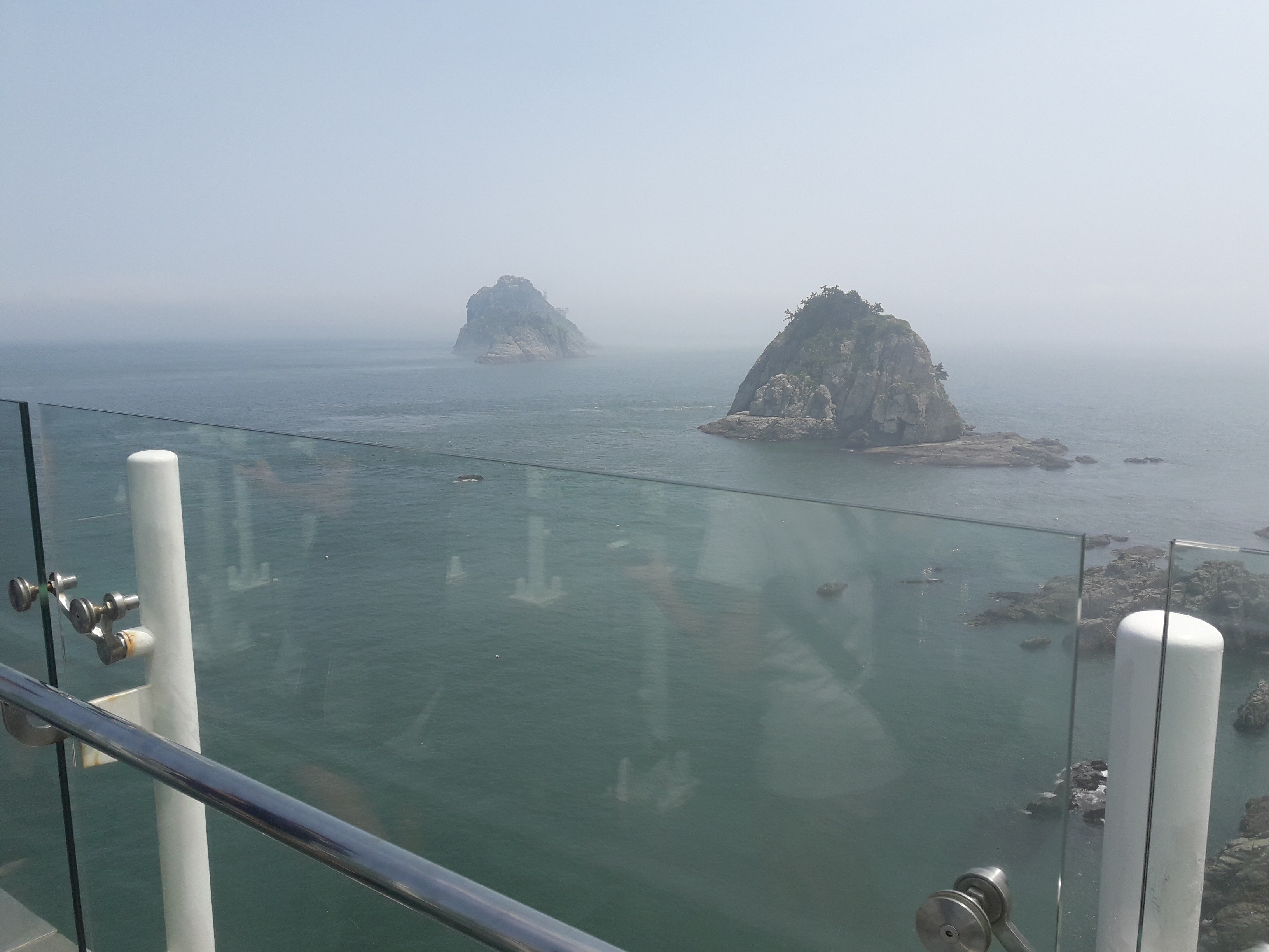
Oryukdo (literally meaning ''Five–Six island'') is group of islands located in Yongho-dong, Nam-gu, Busan, South Korea South Korea, officially the Republic of Korea (ROK), is a country in East Asia, constituting the southern part of the Korean Peninsula and sharing a land border with North Korea. Its western border is formed by the Yellow Sea, while its eas .... The name reflects the fact that the island group can consist of either five or six islands, depending on the current tides. The islands are uninhabited except for Deungdaedo, which has a lighthouse. The other islands are Usakdo, Surido, Gonggotdo, and Guldo. Depending on water level, Usakdo can also be separated into two islands, which are then named Bangpaedo and Sol. The Oryukdo Skywalk is a glass viewing platform positioned on a cliff overlooking the islands which opened in 2013. References Islands of Busan Nam District, Busan Islands of the Sea of Japan {{SouthKorea-geo-stub ... [...More Info...] [...Related Items...] OR: [Wikipedia] [Google] [Baidu] |
Korea Institute Of Maritime And Fisheries Technology
The Korea Institute of Maritime and Fisheries Technology, or KIMFT, is a maritime education and research institute operated by the government of South Korea. It is based in Yeongdang-dong, Nam-gu, Busan, with an auxiliary campus on Yeongdo island near Busan Port. Each campus includes a dormitory for trainees. The Institute was formed in 1998 from the merger of the Korea Fishing Training Center with the Korea Maritime Training and Research Institute. The first was established in 1965 as the Korea Deep-sea Training Institute. In 1978, it became an independent corporation. The research institute was founded in 1983, attached to Korea Maritime and Ocean University. The two were merged by an act of the National Assembly of South Korea passed in 1997. In addition to its research work, KIMFT offers a range of professional certifications. These include a certification in fish medicine. See also * Fishing industry of South Korea *Government of South Korea The Government ... [...More Info...] [...Related Items...] OR: [Wikipedia] [Google] [Baidu] |
Korea Under Japanese Rule
Between 1910 and 1945, Korea was ruled as a part of the Empire of Japan. Joseon Korea had come into the Japanese sphere of influence with the Japan–Korea Treaty of 1876; a complex coalition of the Meiji government, military, and business officials began a process of integrating Korea's politics and economy with Japan. The Korean Empire, proclaimed in 1897, became a protectorate of Japan with the Japan–Korea Treaty of 1905; thereafter Japan ruled the country indirectly through the Japanese Resident-General of Korea. Japan formally annexed the Korean Empire with the Japan–Korea Treaty of 1910, without the consent of the former Korean Emperor Gojong, the regent of the Emperor Sunjong. Upon its annexation, Japan declared that Korea would henceforth be officially named Chōsen. This name was recognized internationally until the end of Japanese colonial rule. The territory was administered by the Governor-General of Chōsen based in Keijō (Seoul). Japanese rule prioritized ... [...More Info...] [...Related Items...] OR: [Wikipedia] [Google] [Baidu] |
Salt Pan (evaporation)
A salt evaporation pond is a shallow artificial salt pan designed to extract salts from sea water or other brines. The Salt pans are shallow and large of size because it will be easier for sunlight to travel and reach the sea water. Natural salt pans are geological formations that are also created by water evaporating and leaving behind salts. Some salt evaporation ponds are only slightly modified from their natural version, such as the ponds on Great Inagua in the Bahamas, or the ponds in Jasiira, a few kilometres south of Mogadishu, where seawater is trapped and left to evaporate in the sun. The seawater or brine is fed into large ponds and water is drawn out through natural evaporation which allows the salt to be subsequently harvested. The ponds also provide a productive resting and feeding ground for many species of waterbirds, which may include endangered species. The ponds are commonly separated by levees. Salt evaporation ponds may also be called salterns, salt works or ... [...More Info...] [...Related Items...] OR: [Wikipedia] [Google] [Baidu] |
Imugi
Korean dragons are legendary creatures in Korean mythology and folklore. The appearance of the dragon reflects its relation to its East Asian counterparts, including the Chinese dragons. Korean dragons Whereas most dragons in European mythology are linked to the elements of fire and destruction, dragons in Korean mythology are primarily benevolent beings related to water and agriculture, often considered bringers of rain and clouds. Hence, many Korean dragons are said to have resided in rivers, lakes, oceans, or even deep mountain ponds. The symbol of the dragon has been used extensively in Korean culture, both in Korean mythology and ancient Korean art. Ancient texts sometimes mention sentient ''speaking'' dragons, capable of understanding complex emotions such as devotion, kindness, and gratitude. One particular Korean legend speaks of the great King Munmu, who on his deathbed wished to become a " Dragon of the East Sea in order to protect Korea". The Korean dragon is in ... [...More Info...] [...Related Items...] OR: [Wikipedia] [Google] [Baidu] |


