|
Yablonovy Mountains
The Yablonoi Mountains or Yablonovy Mountains ( rus, Яблоновый хребет, bua, Яабланай шэлэ нуруу, ; mn, Яблоны нуруу, ''Yablony nuruu'') are a mountain range, in Transbaikal (mainly in Zabaykalsky Krai), Siberia, Russia. The range is sparsely inhabited with most settlements engaged in mining. The area is especially rich in tin. The city of Chita lies between the Yablonoi Mountains to the west and the Chersky Range to the east.Google Earth The Trans-Siberian Railroad passes the mountains at Chita and runs parallel to the range before going through a tunnel to bypass the heights. Geography The Yablonoi Mountains stretch for about in a northeast–southwest direction. They rise mostly in the western part of the Zabaikalsky Krai, with a small section in the southeastern part of Buryatia. The width of the range varies between and . The Vitim Plateau lies to the north and the Borshchovochny Range to the east of the range. The tallest pe ... [...More Info...] [...Related Items...] OR: [Wikipedia] [Google] [Baidu] |
Russia
Russia (, , ), or the Russian Federation, is a List of transcontinental countries, transcontinental country spanning Eastern Europe and North Asia, Northern Asia. It is the List of countries and dependencies by area, largest country in the world, with its internationally recognised territory covering , and encompassing one-eighth of Earth's inhabitable landmass. Russia extends across Time in Russia, eleven time zones and shares Borders of Russia, land boundaries with fourteen countries, more than List of countries and territories by land borders, any other country but China. It is the List of countries and dependencies by population, world's ninth-most populous country and List of European countries by population, Europe's most populous country, with a population of 146 million people. The country's capital and List of cities and towns in Russia by population, largest city is Moscow, the List of European cities by population within city limits, largest city entirely within E ... [...More Info...] [...Related Items...] OR: [Wikipedia] [Google] [Baidu] |
Siberia
Siberia ( ; rus, Сибирь, r=Sibir', p=sʲɪˈbʲirʲ, a=Ru-Сибирь.ogg) is an extensive geographical region, constituting all of North Asia, from the Ural Mountains in the west to the Pacific Ocean in the east. It has been a part of Russia since the latter half of the 16th century, after the Russians conquered lands east of the Ural Mountains. Siberia is vast and sparsely populated, covering an area of over , but home to merely one-fifth of Russia's population. Novosibirsk, Krasnoyarsk and Omsk are the largest cities in the region. Because Siberia is a geographic and historic region and not a political entity, there is no single precise definition of its territorial borders. Traditionally, Siberia extends eastwards from the Ural Mountains to the Pacific Ocean, and includes most of the drainage basin of the Arctic Ocean. The river Yenisey divides Siberia into two parts, Western and Eastern. Siberia stretches southwards from the Arctic Ocean to the hills of north-ce ... [...More Info...] [...Related Items...] OR: [Wikipedia] [Google] [Baidu] |
Ingoda (river)
The Ingoda (; mn, Ингэдэй, ''Ingedei''; bua, Ангида, ''Angida'') is a river in Zabaykalsky Krai of Russia. The river is long and the area of its basin is . Geography In its upper course it flows at the feet of the Khentei Range. Together with the Onon, it forms the Shilka. The Ingoda freezes in early November and stays frozen until late April. The city of Chita lies at the confluence of the Ingoda and the Chitinka. A major portion of the Trans-Siberian Railway lies along the Ingoda valley. The name derives from the Evenki word ''ingakta'' which means "river with pebbly and sandy banks".E.M. Pospelov, ''Geograficheskie nazvaniya mira'' (Moscow: Russkie slovari, 1998), p. 169. Lake Kenon, located in the western outskirts of Chita, is part of the Ingoda river basin. See also * Chersky Range (Transbaikalia) The Chersky Range ( rus, Хребет Черского) is a mountain range in the Transbaikal Region (Zabaykalsky Krai) of Siberia, Russia. The range rises e ... [...More Info...] [...Related Items...] OR: [Wikipedia] [Google] [Baidu] |
Khilok (river)
The Khilok (russian: Хилок; mn, Хилго/Khilgo,Secret History of the Mongols paragraph 109O.Bavuu, "Historic lands mentioned in the Secret History of the Mongols, 2005 bua, Хёлго/Khyoolgo) is a river in Eastern Siberia, a right tributary of the Selenga. The length of the river is and its watershed is . There are a few settlements on its banks: Khilok, Bada etc. Arakhley Lake belongs to the Khilok river basin. See also *List of rivers of Russia See also *Selenga Highlands *List of rivers of Russia Russia can be divided into a European and an Asian part. The dividing line is generally considered to be the Ural Mountains. The European part is drained into the Arctic Ocean, Baltic Sea, Black Sea, and Caspian Sea. The Asian part is drained into ... References Rivers of Zabaykalsky Krai Rivers of Buryatia {{Russia-river-stub ... [...More Info...] [...Related Items...] OR: [Wikipedia] [Google] [Baidu] |
Karenga (river)
The Karenga (russian: Каренга) is a river in Zabaykalsky Krai, southern East Siberia, Russia. It is long, and has a drainage basin of . The area through which the river flows is inhabited by indigenous Tungus people. There are Neolithic archaeological sites near the mouth of the river where ancient ceramic remains belonging to the Ust-Karenga Culture have been found. Course The Karenga is a right tributary of the Vitim. Its sources are in the Chingikhan Saddle, located between the Yablonoi Mountains and the Chersky Range. Kontalaksky Golets, the highest peak of the Yablonoi rises to the NW of the river valley, near Tungokochen.Google Earth It flows in a mainly northeastern direction within a winding channel. The vegetation along the banks of the river is mainly sparse larch taiga. Its lower course is at the eastern end of the Vitim Plateau. Finally, at the border with Buryatia it meets the Vitim from its mouth in the Lena. [...More Info...] [...Related Items...] OR: [Wikipedia] [Google] [Baidu] |
Konda (Vitim)
The Konda (russian: Конда) is a river in Buryatia, southern East Siberia, Russia. It is long, and has a drainage basin of . There are a few inhabited places close to the banks of the river, including Tselinny, Konda, Telemba and Alekseevka in the Yeravninsky District.Google Earth The Konda is a river rich in fish. Tourists regularly visit the area for fishing and watersports. There is a military training ground of the Russian Armed Forces Eastern Military District to the west of the left bank of the river in the area of Telemba village. Course The Konda is a right tributary of the Vitim. Its sources are in the small Khudan Range, west of Chita. It flows across mountainous terrain between the northern section of the Yablonoi Mountains and the Chersky Range. The river flows first in a northeastern direction and then bends gradually meandering northwards in a floodplain with about 500 lakes. The largest and most picturesque is Telemba. Finally the Konda meets the Vitim ... [...More Info...] [...Related Items...] OR: [Wikipedia] [Google] [Baidu] |
Vitim River
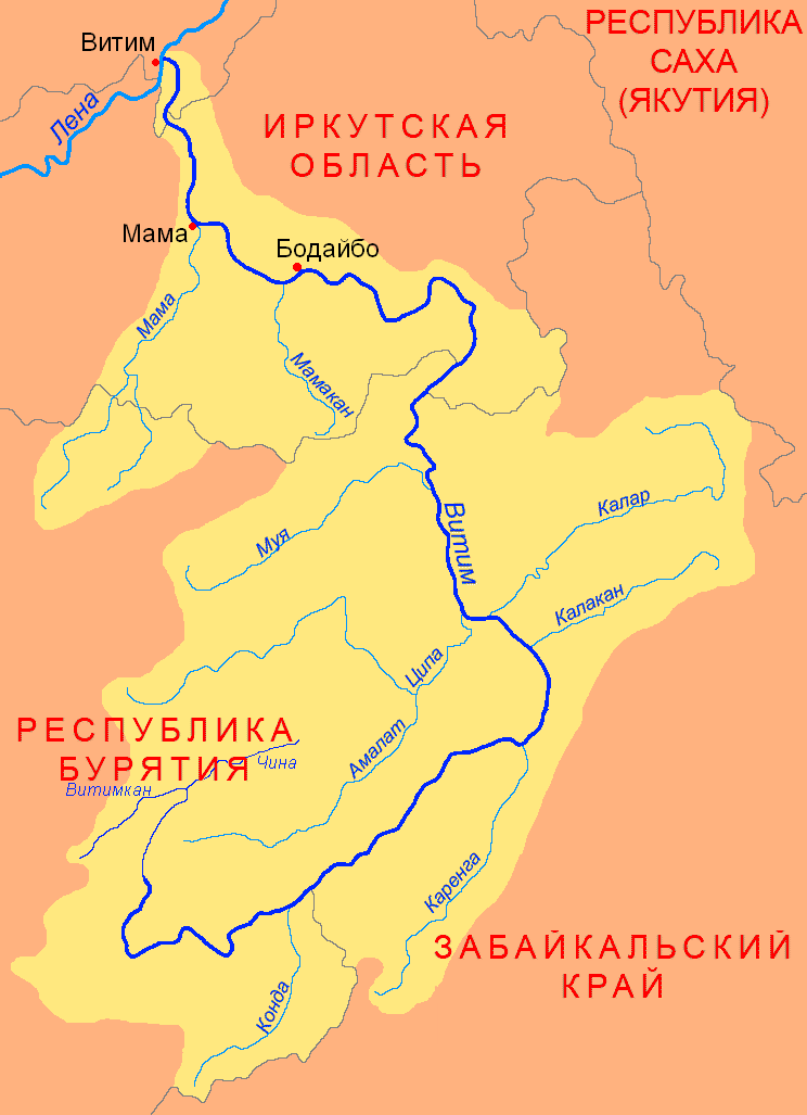
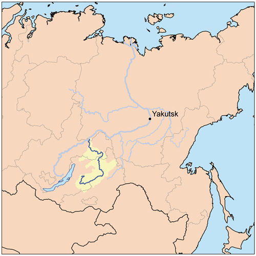
The Vitim (russian: Витим; evn, Витым, ; sah, Виитим, ; Buryat and mn, Витим, ''Vitim'') is a major tributary of the Lena. Its source is east of Lake Baikal, at the confluence of rivers Vitimkan from the west and China from the east. The Vitim flows first south, bends eastwards and then northward in the Vitim Plateau. Then it flows north through the Stanovoy Highlands and the town of Bodaybo. Including river Vitimkan, its western source, it is long, and has a drainage basin of .Витим (река в Бурят. АССР) It is navigable from the Lena to Bodaybo. Upstream, ... [...More Info...] [...Related Items...] OR: [Wikipedia] [Google] [Baidu] |
Golets (geography)
Golets ( rus, голец), plural Goltsy ( rus, Гольцы), is a type of bald mountain summit of certain areas of Siberia. The term is part of the geographical name of several peaks in the region. Description ''Golets'' protrude above the treeline and are usually round or blunt. They are barren, rocky or stony, and only rarely lichens or stunted small scrubs such as Siberian pine, may grow on them. Bare rock slopes, kurums and cliffs are common. The term is usually found in the names of mountaintops in the South Siberian System, especially in Transbaikalia and the Sayan Mountains. The zone below the golets is normally the highest of the altitudinal vegetation zones, above the mountain tundra of the alpine belt.Sizykh, A. (2016) ''Formation of an Ecotone at the Boundary of Forest and Mountain Tundra—Morskoy Ridge as an Example, Middle Part of Eastern Coast of Lake Baikal.'' Open Access Library Journal, 3, 1-4. This kind of mountains may consist in single high peaks connect ... [...More Info...] [...Related Items...] OR: [Wikipedia] [Google] [Baidu] |
Vitim Plateau
Vitim Plateau is a plateau in Buryatia and Zabaykalsky Krai, Russia. The plateau is sparsely populated, the main settlements are Romanovka and Bagdarin. An area of the plateau is an ancient volcanic field with a number of cinder cones and volcanoes, the last of which was active about 810,000 years before present. The P436 regional road connecting Ulan-Ude and Chita passes through Romanovka across the plateau. Geography The Vitim Plateau lies along the headwaters of the Vitim River, a tributary of the Lena between the Southern Muya Range to the north, the Ikat Range to the west, the Yablonoi Mountains to the south, and in the east with the lower reaches of the Kalakan River to the right bank of the lower reaches of the Karenga River (both Vitim tributaries) and the latter's right tributary, the Bugarikta. The Vitim River begins at the confluence of the China and Vitimkan rivers on the plateau and makes a wide bend around the volcanic zone before flowing northwards. Rive ... [...More Info...] [...Related Items...] OR: [Wikipedia] [Google] [Baidu] |
Buryatia
Buryatia, officially the Republic of Buryatia (russian: Республика Бурятия, r=Respublika Buryatiya, p=rʲɪsˈpublʲɪkə bʊˈrʲætʲɪjə; bua, Буряад Улас, Buryaad Ulas, , mn, Буриад Улс, Buriad Uls), is a republic of Russia located in Siberia. It is the historical native land of indigenous Buryats. Formerly part of the Siberian Federal District, it has been a part of the Russian Far East since 2018. Its capital is the city of Ulan-Ude, which means Red Gateway in Buryat Mongolian. Its area is with a population of 978,588 ( 2021 Census). Geography The republic is located in the south-central region of Siberia along the eastern shore of Lake Baikal. *Area: *Borders: **Internal: Irkutsk Oblast (W/NW/N), Zabaykalsky Krai (NE/E/SE/S), Tuva (W) **International: Mongolia (Bulgan Province, Khövsgöl Province and Selenge Province) (S/SE) **Water: Lake Baikal (N) *Highest point: Mount Munku-Sardyk () Rivers Major rivers include: * Barguzi ... [...More Info...] [...Related Items...] OR: [Wikipedia] [Google] [Baidu] |
Tunnel
A tunnel is an underground passageway, dug through surrounding soil, earth or rock, and enclosed except for the entrance and exit, commonly at each end. A pipeline is not a tunnel, though some recent tunnels have used immersed tube construction techniques rather than traditional tunnel boring methods. A tunnel may be for foot or vehicular road traffic, for rail traffic, or for a canal. The central portions of a rapid transit network are usually in the tunnel. Some tunnels are used as sewers or aqueducts to supply water for consumption or for hydroelectric stations. Utility tunnels are used for routing steam, chilled water, electrical power or telecommunication cables, as well as connecting buildings for convenient passage of people and equipment. Secret tunnels are built for military purposes, or by civilians for smuggling of weapons, contraband, or people. Special tunnels, such as wildlife crossings, are built to allow wildlife to cross human-made barriers safely. ... [...More Info...] [...Related Items...] OR: [Wikipedia] [Google] [Baidu] |


