|
Widford Railway Station
Widford railway station served the village of Widford, Hertfordshire Widford is a village and civil parish between Ware and Much Hadham in the East Hertfordshire district of Hertfordshire in England. It covers an area of approximately 1,167 acres and contains 220 houses. The River Ash flows through the north of ..., England, from 1863 to 1964 on the Buntingford branch line. History The station was opened on 3 July 1863 by the Great Eastern Railway. It was situated on the north side of Ware Road. It had a brick-built waiting room and a booking office. At the east end of the platform was a signal box which controlled a siding leading to a cattle and goods dock. Goods traffic ceased on 7 September 1964. The station closed on 16 November 1964. References Disused railway stations in Hertfordshire Former Great Eastern Railway stations Railway stations in Great Britain opened in 1863 Railway stations in Great Britain closed in 1964 1863 establishments in England ... [...More Info...] [...Related Items...] OR: [Wikipedia] [Google] [Baidu] |
Widford, Hertfordshire
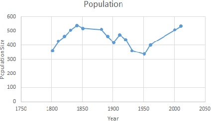
Widford is a village and civil parish between Ware and Much Hadham in the East Hertfordshire district of Hertfordshire in England. It covers an area of approximately 1,167 acres and contains 220 houses. The River Ash flows through the north of the parish. Widford had a population of 534 people in the 2011 census. History The name Widford comes from the old English word 'wid' meaning willow tree and the word 'ford' The Widford commons were extensive and were enclosed under an award of 1856. There was a wood called Lily Wood to the west of the village which was cut down in the late 19th century. Between 1870 and 1872, John Marius Wilson described Widford as: "a parish, with a village, in Ware district, Herts; near the Buntingford railway, 4 miles E by N of Ware. It has a post-office under Ware, and a r. station." Demography and employment The population of Widford was first recorded in 1801 at 361. The population peaked in 1841 at 539. In the most recent census in 2011 the ... [...More Info...] [...Related Items...] OR: [Wikipedia] [Google] [Baidu] |
Hertfordshire
Hertfordshire ( or ; often abbreviated Herts) is one of the home counties in southern England. It borders Bedfordshire and Cambridgeshire to the north, Essex to the east, Greater London to the south, and Buckinghamshire to the west. For government statistical purposes, it forms part of the East of England region. Hertfordshire covers . It derives its name – via the name of the county town of Hertford – from a hart (stag) and a ford, as represented on the county's coat of arms and on the flag. Hertfordshire County Council is based in Hertford, once the main market town and the current county town. The largest settlement is Watford. Since 1903 Letchworth has served as the prototype garden city; Stevenage became the first town to expand under post-war Britain's New Towns Act of 1946. In 2013 Hertfordshire had a population of about 1,140,700, with Hemel Hempstead, Stevenage, Watford and St Albans (the county's only ''city'') each having between 50,000 and 10 ... [...More Info...] [...Related Items...] OR: [Wikipedia] [Google] [Baidu] |
Ordnance Survey National Grid
The Ordnance Survey National Grid reference system (OSGB) (also known as British National Grid (BNG)) is a system of geographic grid references used in Great Britain, distinct from latitude and longitude. The Ordnance Survey (OS) devised the national grid reference system, and it is heavily used in their survey data, and in maps based on those surveys, whether published by the Ordnance Survey or by commercial map producers. Grid references are also commonly quoted in other publications and data sources, such as guide books and government planning documents. A number of different systems exist that can provide grid references for locations within the British Isles: this article describes the system created solely for Great Britain and its outlying islands (including the Isle of Man); the Irish grid reference system was a similar system created by the Ordnance Survey of Ireland and the Ordnance Survey of Northern Ireland for the island of Ireland. The Universal Transverse Me ... [...More Info...] [...Related Items...] OR: [Wikipedia] [Google] [Baidu] |
Great Eastern Railway
The Great Eastern Railway (GER) was a pre-grouping British railway company, whose main line linked London Liverpool Street to Norwich and which had other lines through East Anglia. The company was grouped into the London and North Eastern Railway in 1923. Formed in 1862 after the amalgamation of the Eastern Counties Railway and several other smaller railway companies the GER served Cambridge, Chelmsford, Colchester, Great Yarmouth, Ipswich, King's Lynn, Lowestoft, Norwich, Southend-on-Sea (opened by the GER in 1889), and East Anglian seaside resorts such as Hunstanton (whose prosperity was largely a result of the GER's line being built) and Cromer. It also served a suburban area, including Enfield, Chingford, Loughton and Ilford. This suburban network was, in the early 20th century, the busiest steam-hauled commuter system in the world. The majority of the Great Eastern's locomotives and rolling stock were built at Stratford Works, part of which was on the site of ... [...More Info...] [...Related Items...] OR: [Wikipedia] [Google] [Baidu] |
London And North Eastern Railway
The London and North Eastern Railway (LNER) was the second largest (after LMS) of the " Big Four" railway companies created by the Railways Act 1921 in Britain. It operated from 1 January 1923 until nationalisation on 1 January 1948. At that time, it was divided into the new British Railways' Eastern Region, North Eastern Region, and partially the Scottish Region. History The company was the second largest created by the Railways Act 1921. The principal constituents of the LNER were: * Great Eastern Railway * Great Central Railway * Great Northern Railway * Great North of Scotland Railway * Hull and Barnsley Railway * North British Railway * North Eastern Railway The total route mileage was . The North Eastern Railway had the largest route mileage of , whilst the Hull and Barnsley Railway was . It covered the area north and east of London. It included the East Coast Main Line from London to Edinburgh via York and Newcastle upon Tyne and the routes from Edinburg ... [...More Info...] [...Related Items...] OR: [Wikipedia] [Google] [Baidu] |
Eastern Region Of British Railways
The Eastern Region was a region of British Railways from 1948, whose operating area could be identified from the dark blue signs and colour schemes that adorned its station and other railway buildings. Together with the North Eastern Region (which it absorbed in 1967), it covered most lines of the former London and North Eastern Railway, except in Scotland. By 1988 the Eastern Region had been divided again into the Eastern Region and the new Anglia Region, with the boundary points being between and , and between and . The region ceased to be an operating unit in its own right in the 1980s and was wound up at the end of 1992. History The region was formed in at nationalisation in 1948, mostly out of the former Great Northern, Great Eastern and Great Central lines that were merged into the LNER in 1923. Of all the "Big Four" pre-nationalisation railway companies, the LNER was most in need of significant investment. In the immediate post-war period there was a need to rebuild ... [...More Info...] [...Related Items...] OR: [Wikipedia] [Google] [Baidu] |
Former Great Eastern Railway Stations
A former is an object, such as a template, gauge or cutting die, which is used to form something such as a boat's hull. Typically, a former gives shape to a structure that may have complex curvature. A former may become an integral part of the finished structure, as in an aircraft fuselage, or it may be removable, being using in the construction process and then discarded or re-used. Aircraft formers Formers are used in the construction of aircraft fuselage, of which a typical fuselage has a series from the nose to the empennage, typically perpendicular to the longitudinal axis of the aircraft. The primary purpose of formers is to establish the shape of the fuselage and reduce the column length of stringers to prevent instability. Formers are typically attached to longerons, which support the skin of the aircraft. The "former-and-longeron" technique (also called stations and stringers) was adopted from boat construction, and was typical of light aircraft built until the adv ... [...More Info...] [...Related Items...] OR: [Wikipedia] [Google] [Baidu] |
Railway Stations In Great Britain Opened In 1863
Rail transport (also known as train transport) is a means of transport that transfers passengers and goods on wheeled vehicles running on rails, which are incorporated in tracks. In contrast to road transport, where the vehicles run on a prepared flat surface, rail vehicles (rolling stock) are directionally guided by the tracks on which they run. Tracks usually consist of steel rails, installed on sleepers (ties) set in ballast, on which the rolling stock, usually fitted with metal wheels, moves. Other variations are also possible, such as "slab track", in which the rails are fastened to a concrete foundation resting on a prepared subsurface. Rolling stock in a rail transport system generally encounters lower frictional resistance than rubber-tyred road vehicles, so passenger and freight cars (carriages and wagons) can be coupled into longer trains. The operation is carried out by a railway company, providing transport between train stations or freight customer facilit ... [...More Info...] [...Related Items...] OR: [Wikipedia] [Google] [Baidu] |
Railway Stations In Great Britain Closed In 1964
Rail transport (also known as train transport) is a means of transport that transfers passengers and goods on wheeled vehicles running on rails, which are incorporated in tracks. In contrast to road transport, where the vehicles run on a prepared flat surface, rail vehicles (rolling stock) are directionally guided by the tracks on which they run. Tracks usually consist of steel rails, installed on sleepers (ties) set in ballast, on which the rolling stock, usually fitted with metal wheels, moves. Other variations are also possible, such as "slab track", in which the rails are fastened to a concrete foundation resting on a prepared subsurface. Rolling stock in a rail transport system generally encounters lower frictional resistance than rubber-tyred road vehicles, so passenger and freight cars (carriages and wagons) can be coupled into longer trains. The operation is carried out by a railway company, providing transport between train stations or freight customer facil ... [...More Info...] [...Related Items...] OR: [Wikipedia] [Google] [Baidu] |
1863 Establishments In England
Events January–March * January 1 – Abraham Lincoln signs the Emancipation Proclamation during the third year of the American Civil War, making the abolition of slavery in the Confederate states an official war goal. It proclaims the freedom of 3.1 million of the nation's four million slaves and immediately frees 50,000 of them, with the rest freed as Union armies advance. * January 2 – Lucius Tar Painting Master Company (''Teerfarbenfabrik Meirter Lucius''), predecessor of Hoechst, as a worldwide chemical manufacturing brand, founded in a suburb of Frankfurt am Main, Germany. * January 4 – The New Apostolic Church, a Christian and chiliastic church, is established in Hamburg, Germany. * January 7 – In the Swiss canton of Ticino, the village of Bedretto is partly destroyed and 29 killed, by an avalanche. * January 8 ** The Yorkshire County Cricket Club is founded at the Adelphi Hotel, in Sheffield, England. ** American Civil War – ... [...More Info...] [...Related Items...] OR: [Wikipedia] [Google] [Baidu] |


