|
West Lynn, Norfolk
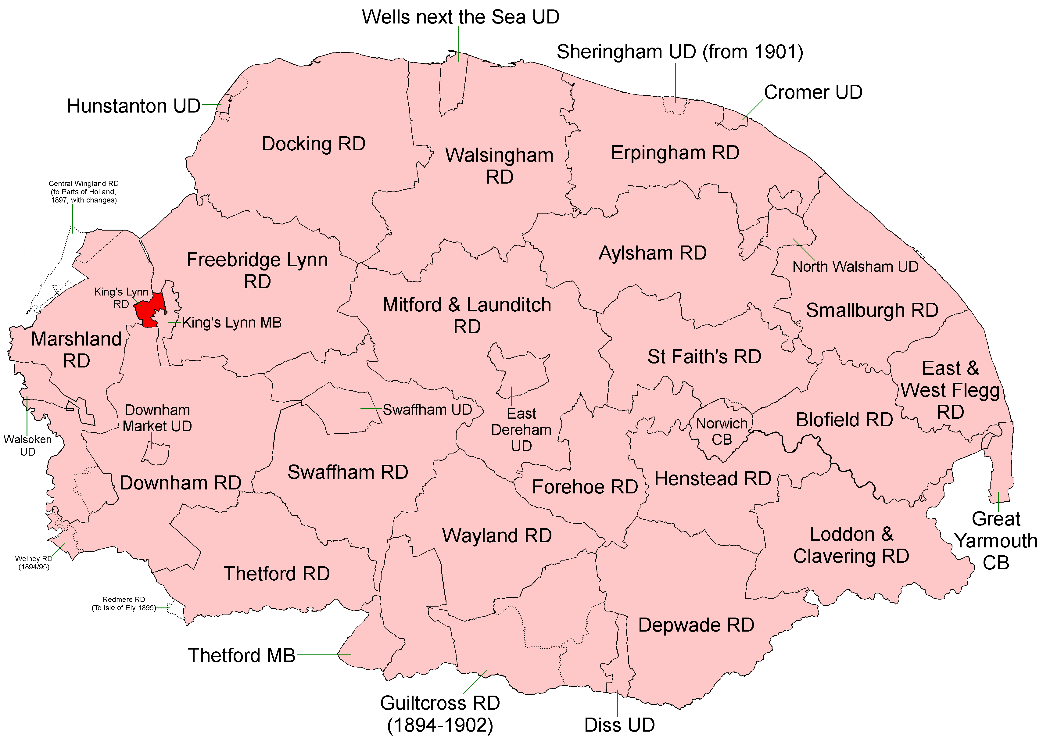
West Lynn is a village and former civil parish, now in the unparished area of King's Lynn, in the King's Lynn and West Norfolk district, in the county of Norfolk, England. It is west of the River Great Ouse, linked to the main part of King's Lynn by the King's Lynn passenger ferry or by a circuitous 4 km road journey. West Lynn was originally constituted as a separate civil parish, and in 1894 this became the sole parish in the new King's Lynn Rural District. In 1931 the parish had a population of 931. The parish and district were split on 1 April 1935 with the urban part becoming part of the borough of King's Lynn, and the rest becoming part of the parish of Clenchwarton in Marshland Rural District. Today the name West Lynn usually refers to the former part of the borough of King's Lynn, forming part of the unparished urban area of King's Lynn. It is in the South and West Lynn Ward of King's Lynn and West Norfolk Council. West Lynn has a primary school and a range of basic se ... [...More Info...] [...Related Items...] OR: [Wikipedia] [Google] [Baidu] |
King's Lynn And West Norfolk
King's Lynn and West Norfolk is a local government district with borough status in Norfolk, England. Its council is based in the town of King's Lynn. The population of the Local Authority at the 2011 Census was 147,451. History The district was formed in 1974 by the merger of the Municipal Borough of King's Lynn, Hunstanton and Downham Market urban districts along with Docking Rural District, Downham Rural District, Freebridge Lynn Rural District and Marshland Rural District. The district was originally known as just West Norfolk, and adopted its present name in 1981. Politics Elections to the borough council are held every four years, with all of the 55 councillors, representing 42 wards, on the council being elected at each election. After being under no overall control from the 1999 election, the Conservative party gained a majority at the 2003 election and has held one ever since, although losing a large number of seats due to the resurgence of the Independent Group ... [...More Info...] [...Related Items...] OR: [Wikipedia] [Google] [Baidu] |
A Vision Of Britain Through Time
The Great Britain Historical GIS (or GBHGIS) is a spatially enabled database that documents and visualises the changing human geography of the British Isles, although is primarily focussed on the subdivisions of the United Kingdom mainly over the 200 years since the first census in 1801. The project is currently based at the University of Portsmouth, and is the provider of the website ''A Vision of Britain through Time''. NB: A "GIS" is a geographic information system, which combines map information with statistical data to produce a visual picture of the iterations or popularity of a particular set of statistics, overlaid on a map of the geographic area of interest. Original GB Historical GIS (1994–99) The first version of the GB Historical GIS was developed at Queen Mary, University of London between 1994 and 1999, although it was originally conceived simply as a mapping extension to the existing Labour Markets Database (LMDB). The system included digital boundaries for r ... [...More Info...] [...Related Items...] OR: [Wikipedia] [Google] [Baidu] |
Villages In Norfolk
A village is a clustered human settlement or community, larger than a hamlet but smaller than a town (although the word is often used to describe both hamlets and smaller towns), with a population typically ranging from a few hundred to a few thousand. Though villages are often located in rural areas, the term urban village is also applied to certain urban neighborhoods. Villages are normally permanent, with fixed dwellings; however, transient villages can occur. Further, the dwellings of a village are fairly close to one another, not scattered broadly over the landscape, as a dispersed settlement. In the past, villages were a usual form of community for societies that practice subsistence agriculture, and also for some non-agricultural societies. In Great Britain, a hamlet earned the right to be called a village when it built a church. [...More Info...] [...Related Items...] OR: [Wikipedia] [Google] [Baidu] |
Phil Easton
Phil Easton (8 August 1949 – 2 February 2009) was an English radio presenter and football announcer, best known for his work at Liverpool's Radio City from 1974 to 2009. Career Easton joined Radio City late 1975, and became known for his evening rock show "The Great Easton Express", which ran for 12 years in total on and off. During Easton's career at Radio City he organised "Battle of The Bands". "Battle of the Bands" helping smaller bands find fame. From the late 1980s to mid 1990s Easton moved away from Radio City to help launch Orchard FM, now known as Heart Somerset. While there he took on several different roles, such as programme controller and head of music. After this period away, he returned to Radio City. Easton helped to relaunch City Talk in January 2008. He interviewed many famous figures, including the then prime minister Gordon Brown. Following Easton's death, Brown said: "Phil was an accomplished and talented broadcaster who was on the top of his game whe ... [...More Info...] [...Related Items...] OR: [Wikipedia] [Google] [Baidu] |
Eastern Daily Press
The ''Eastern Daily Press'' (''EDP'') is a regional newspaper covering Norfolk, northern parts of Suffolk and eastern Cambridgeshire, and is published daily in Norwich, UK. Founded in 1870 as a broadsheet called the ''Eastern Counties Daily Press'', it changed its name to the ''Eastern Daily Press'' in 1872. It switched to the compact ( tabloid) format in the mid-1990s. The paper is now owned and published by Archant, formerly known as Eastern Counties Newspapers Group. It aims to represent the interests of the local population in the region in a non-partisan way, its mission statement being to "champion a fair deal for the future prosperity of the region". Despite its commitment to regional issues, the ''EDP'' also covers national (and international) news and sport. The paper also produces a sister edition, the ''Norwich Evening News''. Notable editors *Edmund Rogers Edmund Dawson Rogers (7 August 1823 – 28 September 1910), was an English journalist and spiritualist. ... [...More Info...] [...Related Items...] OR: [Wikipedia] [Google] [Baidu] |
King's Lynn And West Norfolk Council
King's Lynn and West Norfolk is a local government district with borough status in Norfolk, England. Its council is based in the town of King's Lynn. The population of the Local Authority at the 2011 Census was 147,451. History The district was formed in 1974 by the merger of the Municipal Borough of King's Lynn, Hunstanton and Downham Market urban districts along with Docking Rural District, Downham Rural District, Freebridge Lynn Rural District and Marshland Rural District. The district was originally known as just West Norfolk, and adopted its present name in 1981. Politics Elections to the borough council are held every four years, with all of the 55 councillors, representing 42 wards, on the council being elected at each election. After being under no overall control from the 1999 election, the Conservative party gained a majority at the 2003 election and has held one ever since, although losing a large number of seats due to the resurgence of the Independent Group i ... [...More Info...] [...Related Items...] OR: [Wikipedia] [Google] [Baidu] |
Marshland Rural District
Marshland Rural District was a rural district in Norfolk, England from 1894 to 1974. It was formed under the Local Government Act 1894 based on the Marshland rural sanitary district, and was named after the Freebridge Marshland hundred. It covered an area to the west of King's Lynn on the borders of Lincolnshire and the Isle of Ely. In 1930 a new parish of Nordelph was created in Downham RD, taking land mostly out of the Marshland RD parishes of Upwell and Outwell Outwell is a village and civil parish in the borough of King's Lynn and West Norfolk, in the English county of Norfolk.Ordnance Survey (2006). ''OS Explorer Map 228 – March & Ely''. At the 2011 Census, the parish had a population of 2,083, an .... During the period 1933-1935 it absorbed most of the area of the disbanded Walsoken Urban District, with other minor boundary changes. In 1974, the district was abolished under the Local Government Act 1972, and became part of the West Norfolk district. Statis ... [...More Info...] [...Related Items...] OR: [Wikipedia] [Google] [Baidu] |
Clenchwarton
Clenchwarton is a village, civil parish and electoral ward in the English county of Norfolk. It is located about west of the River Great Ouse, about from the town of King's Lynn on the east side of the river. History Clenchwarton's name is of Anglo-Saxon origin and derives from the Old English for a hill dweller's farmstead or settlement. In the Domesday Book, Clenchwarton is recorded as an abandoned village with no recorded population in the hundred of Freebridge. The village was part of the estates of William d'Ecounis. The abandonment of the village was likely the result of the Norman reprisals in retaliation for the Ely Rebellion of 1070, led by Hereward the Wake. The village was also surveyed by the Victorian traveller, John Marius, in the 1870s. He wrote the following about the village in the '' Imperial Gazetteer'': "church is old but good. There are a N.Methodist chapel, and a national school." Geography In the 2011 Census, Clenchwarton was recorded as having ... [...More Info...] [...Related Items...] OR: [Wikipedia] [Google] [Baidu] |
King's Lynn Rural District
King's Lynn Rural District was a rural district in Norfolk from 1894 to 1935. It was situated on the west bank of the River Great Ouse, opposite the town of King's Lynn, and comprised the then single civil parish of West Lynn. The district was split in 1935 with the urban part becoming part of the borough of King's Lynn, and the rest becoming part of Marshland Rural District. Today the area covered by the old rural district is within the district A district is a type of administrative division that, in some countries, is managed by the local government. Across the world, areas known as "districts" vary greatly in size, spanning regions or county, counties, several municipality, municipa ... of King's Lynn and West Norfolk. References *https://web.archive.org/web/20070930225953/http://www.visionofbritain.org.uk/relationships.jsp?u_id=10092474&c_id=10001043 {{coord, 52.75, 0.37, type:adm3rd_dim:10000_region:GB-NFK, display=title Historical districts of Norfolk Local ... [...More Info...] [...Related Items...] OR: [Wikipedia] [Google] [Baidu] |
Norfolk
Norfolk () is a ceremonial and non-metropolitan county in East Anglia in England. It borders Lincolnshire to the north-west, Cambridgeshire to the west and south-west, and Suffolk to the south. Its northern and eastern boundaries are the North Sea, with The Wash to the north-west. The county town is the city of Norwich. With an area of and a population of 859,400, Norfolk is a largely rural county with a population density of 401 per square mile (155 per km2). Of the county's population, 40% live in four major built up areas: Norwich (213,000), Great Yarmouth (63,000), King's Lynn (46,000) and Thetford (25,000). The Broads is a network of rivers and lakes in the east of the county, extending south into Suffolk. The area is protected by the Broads Authority and has similar status to a national park. History The area that was to become Norfolk was settled in pre-Roman times, (there were Palaeolithic settlers as early as 950,000 years ago) with camps along the highe ... [...More Info...] [...Related Items...] OR: [Wikipedia] [Google] [Baidu] |
1 E3 M
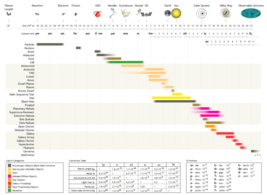
The following are examples of orders of magnitude for different lengths. __TOC__ Overview Detailed list To help compare different orders of magnitude, the following list describes various lengths between 1.6 \times 10^ metres and 10^metres. Subatomic scale Atomic to cellular scale Cellular to human scale Human to astronomical scale Astronomical scale Less than 1 zeptometre The ' ( SI symbol: ') is a unit of length in the metric system equal to . To help compare different orders of magnitude, this section lists lengths shorter than 10−21 m (1 zm). *1.6 × 10⁻⁵ quectometres (1.6 × 10⁻³⁵ metres) – the Planck length (Measures of distance shorter than this do not make physical sense, according to current theories of physics.) *1 qm – 1 quectometre, the smallest named subdivision of the metre in the SI base unit of length, one nonillionth of a metre *1 rm – 1 rontometre, a subdivision of the metre in the SI base unit of length, one octilliont ... [...More Info...] [...Related Items...] OR: [Wikipedia] [Google] [Baidu] |
River Great Ouse
The River Great Ouse () is a river in England, the longest of several British rivers called "Ouse". From Syresham in Northamptonshire, the Great Ouse flows through Buckinghamshire, Bedfordshire, Cambridgeshire and Norfolk to drain into the Wash and the North Sea near Kings Lynn. Authorities disagree both on the river's source and its length with one quoting and another . Mostly flowing north and east, it is the fifth longest river in the United Kingdom. The Great Ouse has been historically important for commercial navigation, and for draining the low-lying region through which it flows; its best-known tributary is the Cam, which runs through Cambridge. Its lower course passes through drained wetlands and fens and has been extensively modified, or channelised, to relieve flooding and provide a better route for barge traffic. The unmodified river would have changed course regularly after floods. The name ''Ouse'' is from the Celtic or pre-Celtic *''Udso-s'', and probably me ... [...More Info...] [...Related Items...] OR: [Wikipedia] [Google] [Baidu] |


