|
Windham Vermont Senate District, 2002–2012
The Windham Senate District is one of 13 Vermont Senate districts included in the redistricting and reapportionment plan developed by the Vermont General Assembly following the 2000 U.S. Census. The plan applies to legislatures elected in 2002, 2004, 2006, 2008, and 2010. A new plan will be developed in 2012 following the 2010 U.S. Census. The Windham District includes all of Windham County except the town of Wilmington. As of the 2000 census, the state as a whole had a population of 608,827. As there are a total of 30 Senators, there were 20,294 residents per senator. The Windham District had a population of 41,991 in that same census. The district is apportioned two senators. This equals 20,996 residents per senator, 3.46% above the state average. District Senators ''2005-2006'' * Roderick M. Gander, Democrat * Jeanette K. White, Democrat ''2007-2008'' *Peter Shumlin, Democrat * Jeanette K. White, Democrat ''As of 2017'' *Becca Balint, Democrat * Jeanette K. White, De ... [...More Info...] [...Related Items...] OR: [Wikipedia] [Google] [Baidu] |
Vermont Senate Districts, 2002-2012
Vermont () is a state in the northeast New England region of the United States. Vermont is bordered by the states of Massachusetts to the south, New Hampshire to the east, and New York to the west, and the Canadian province of Quebec to the north. Admitted to the union in 1791 as the 14th state, it is the only state in New England not bordered by the Atlantic Ocean. According to the 2020 U.S. census, the state has a population of 643,503, ranking it the second least-populated in the U.S. after Wyoming. It is also the nation's sixth-smallest state in area. The state's capital Montpelier is the least-populous state capital in the U.S., while its most-populous city, Burlington, is the least-populous to be a state's largest. For some 12,000 years, indigenous peoples have inhabited this area. The competitive tribes of the Algonquian-speaking Abenaki and Iroquoian-speaking Mohawk were active in the area at the time of European encounter. During the 17th century, French colon ... [...More Info...] [...Related Items...] OR: [Wikipedia] [Google] [Baidu] |
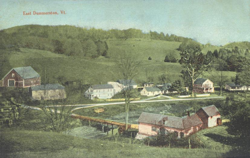
Dummerston, Vermont
Dummerston is a town in Windham County, Vermont, United States. The population was 1,865 at the 2020 United States Census, 2020 census. It is home to the longest covered bridge still in use in Vermont. Its borders include three main villages: Dummerston Center, West Dummerston, and East Dummerston. History Dummerston was part of the Equivalent Lands—several large sections of land given to settlers in the early eighteenth century. It lies on a tract (land), tract given to the Connecticut Colony about 1715 by the Province of Massachusetts Bay as compensation for land mistakenly awarded by the latter to its settlers. In 1716, the town was auctioned to a consortium (which included William Dummer, lieutenant governor of Massachusetts), and named Dummerston. On December 26, 1753, the town was chartered as a New Hampshire grants, New Hampshire grant and renamed Fulham by Governor Benning Wentworth. But when the grant was renegotiated, it reverted to Dummerston. The many brooks and st ... [...More Info...] [...Related Items...] OR: [Wikipedia] [Google] [Baidu] |
Vernon, Vermont
Vernon is a town in Windham County, Vermont, in the United States. The population was 2,192 at the 2020 census. Vernon is the site of the now-defunct Vermont Yankee, the state of Vermont's only nuclear power plant, which closed in December 2014. History The town was chartered in 1672 as part of the Massachusetts Grant. In 1736 the area was granted by Massachusetts as part of Fall Town, and in 1753 the area was granted as Hinsdale. When the Connecticut River was established as a boundary, two separate towns were created: Hinsdale, New Hampshire and Hinsdale, Vermont. The people who lived in Hinsdale, Vermont wanted a separate name, and in 1802 the Vermont legislature changed the town's name to Vernon. The name is said to have been chosen after President George Washington's plantation home, Mount Vernon. Fort Bridgman, in Vernon, was burned in 1755, a casualty of the French and Indian War. Geography According to the United States Census Bureau, the town has a total area of 20.0 ... [...More Info...] [...Related Items...] OR: [Wikipedia] [Google] [Baidu] |
Townshend, Vermont
Townshend is a town in Windham County, Vermont, United States. The town was named for the Townshend family, powerful figures in British politics. The population was 1,291 at the 2020 census. History The land grant for Townshend was chartered by New Hampshire Governor Benning Wentworth, on June 20, 1753. The town was named after Charles Townshend, the Secretary of War under King George III. Between 1755 and 1761, plans and occupation of Townshend were abandoned due to the impact of the French and Indian War. The grant had required the settlement of the town within five years, so in August of 1762, Townshend was regranted under the same stipulations by Governor Wentworth. However, proprietors had already begun meeting again in 1761, and settlement of the town was led by proprietor John Hazeltine in May of that year. The western boundary of New Hampshire was obscure, and there was controversy over whether the area around Townshend was under jurisdiction of the colony of New Hampsh ... [...More Info...] [...Related Items...] OR: [Wikipedia] [Google] [Baidu] |
Stratton, Vermont
Stratton is a town in Windham County, Vermont, United States. The population was 440 at the 2020 census. Geography According to the United States Census Bureau, the town has a total area of 46.9 square miles (121.5 km2), of which 46.4 square miles (120.1 km2) is land and 0.5 square mile (1.4 km2) (1.15%) is water. Stratton Mountain is the high point of the town. Stratton Mountain Resort is at the northern end of the mountain. The community of Stratton Mountain comprises the base of the resort as well as residential development to the north in the town of Winhall. History Daniel Webster spoke to 10,000 Whigs on Stratton Mountain in 1840. Stratton was one of thirteen Vermont towns isolated by flooding caused by Hurricane Irene in 2011. Demographics As of the census of 2000, there were 216 people, 60 households, and 36 families residing in the town. The population density was 2.9 people per square mile (1.1/km2). There were 1,091 housing units at ... [...More Info...] [...Related Items...] OR: [Wikipedia] [Google] [Baidu] |
Somerset, Vermont
Somerset is an unincorporated town in Windham County, Vermont, United States. As of the 2020 census, it had a total population of 6. Somerset is one of five unincorporated towns in Vermont, having been disincorporated in 1937. The town has no local government and the town's affairs are handled by a state-appointed supervisor. Unincorporated communities in Bennington County, Vermont Geography According to the United States Census Bureau, the town had a total area of 28.1 square miles (72.9 km2), of which 26.1 square miles (67.7 km2) is land and 2.0 square miles (5.2 km2) is water. The total area is 7.07% water. It is located high in the southern Green Mountains, with its little habitable terrain sandwiched between the main spine of those mountains and Mount Snow. Demographics At the 2000 census there were 5 people, 2 households, and 1 family residing in the town. The population density was 0.2 people per square mile (0.1/km2). There were 28 h ... [...More Info...] [...Related Items...] OR: [Wikipedia] [Google] [Baidu] |
Rockingham, Vermont
Rockingham is a Town in Windham County, on the southeastern Vermont border in the United States, along the Connecticut River. As of the 2020 census, the population was 4,832. Rockingham includes the incorporated villages of Bellows Falls and Saxtons River, as well as a large rural area west of Interstate 91. Rockingham has no formal town center; instead, town offices and the Rockingham Public Library are located in the village of Bellows Falls. The approximate center is the Rockingham Meeting House, passed by Route 103, a popular east–west route across the state. The Meeting House was built in Rockingham Village, once the main settlement in the town, but with the increased use of water power for manufacturing, population shifted to other villages located on the two rivers in the town. Most of what was left of Rockingham Village (over a dozen buildings, also called the Old Town) burned in a fire on April 14, 1908; the fire came close to the Meeting House but it was saved. The hou ... [...More Info...] [...Related Items...] OR: [Wikipedia] [Google] [Baidu] |
Putney, Vermont
Putney is a town in Windham County, Vermont, United States. The population was 2,617 at the 2020 census. The town's historic core makes up the Putney Village Historic District, which is listed on the National Register of Historic Places. History On December 26, 1753, Colonel Josiah Willard led a proprietors' petition for a Putney charter to be established in the Equivalent Lands. The charter was issued that day by Governor Benning Wentworth – issuer of the New Hampshire Grants under the authority of King George II of Great Britain. Significant settlement of Putney did not begin until after the French and Indian War ended in 1760. The town arose in a large plain on the west side of the Connecticut River, above the mouth of Sacketts Brook. A falls on the brook provided water power for early mills, and it is around that point that the main village was formed. Because the town did not have abundant sources of water power, it was largely bypassed by the Industrial Revolutio ... [...More Info...] [...Related Items...] OR: [Wikipedia] [Google] [Baidu] |
Newfane, Vermont
Newfane is the shire town (county seat) of Windham County, Vermont, United States. The population was 1,645 at the 2020 census. The town includes the villages of Newfane, Williamsville, and South Newfane. History One of the New Hampshire grants, the town was chartered on June 19, 1753, by Governor Benning Wentworth, who named it Fane after John Fane, the 7th Earl of Westmoreland. But hostilities during the French and Indian War prevented its settlement. Because a first town meeting was not held within the required five years, the charter was deemed null and void. So Wentworth issued an entirely new charter on November 3, 1761, as New Fane. The town was settled in 1766 by families from Worcester County, Massachusetts. Newfane became the shire town of the county before 1812. A village was built atop Newfane Hill, including the county buildings. But because of winter travel difficulties, it was relocated to the flatland below in 1825, until 1882 called Fayetteville after the Mar ... [...More Info...] [...Related Items...] OR: [Wikipedia] [Google] [Baidu] |
Marlboro, Vermont
Marlboro is a town in Windham County, Vermont, United States. The population was 1,722 at the 2020 census. The town is home to both the Southern Vermont Natural History Museum and Marlboro College, which hosts the Marlboro Music School and Festival each summer. History Named "New Marlborough" for the Duke of Marlborough until 1800,"Brief History of Marlboro" on the Marlboro Historical Society website the town was a New Hampshire grant chartered on April 29, 1751 to Timothy Dwight and 64 others from , |
Londonderry, Vermont
Londonderry is a town in Windham County, Vermont, United States. It is bounded on the north by Landgrove and Weston, on the east by Windham, on the south by Jamaica and on the west by Winhall and Landgrove. The population was 1,919 in the 2020 census. The town contains the villages of Londonderry and South Londonderry. History Londonderry was first chartered in 1770 to a Col. James Rogers and was known as Kent, which included what is now Windham. The town was again chartered by act of the new Vermont Legislature on April 20, 1780. In this charter, the township was named Londonderry after Londonderry in New Hampshire, which in turn was named after Londonderry in Ireland. Geography According to the United States Census Bureau, the town has a total area of 35.9 square miles (92.9 km2), of which 35.7 square miles (92.4 km2) is land and 0.2 square mile (0.5 km2) (0.59%) is water. The West River flows through the town. Climate This climatic region is ... [...More Info...] [...Related Items...] OR: [Wikipedia] [Google] [Baidu] |
Jamaica, Vermont
Jamaica is a town in Windham County, Vermont, United States. The population was 1,005 at the 2020 census. The town includes the villages of Jamaica, East Jamaica and Rawsonville. Its ZIP code is 05343. The town is home to Jamaica State Park, noted for scenic camping spots and various swimming holes, including Hamilton Falls. The nearest large town is Brattleboro. History In the colonial period, what is now Vermont was disputed territory, with land claims from both New York and New Hampshire. The original grants for this area, issued by the Royal Governor of New York in 1767 and 1772, were for two towns. But in 1777, the Republic of Vermont was established. Ignoring the previous grants, it gave charter on November 7, 1780 for “a tract of vacant land within this state which has not heretofore been granted.” The charter goes on to say “that the same be and is hereby Incorporated into a Township by the name of Jamaica”—its name from the Natick word for beaver and no ... [...More Info...] [...Related Items...] OR: [Wikipedia] [Google] [Baidu] |

.jpg)


