|
Whenuakura
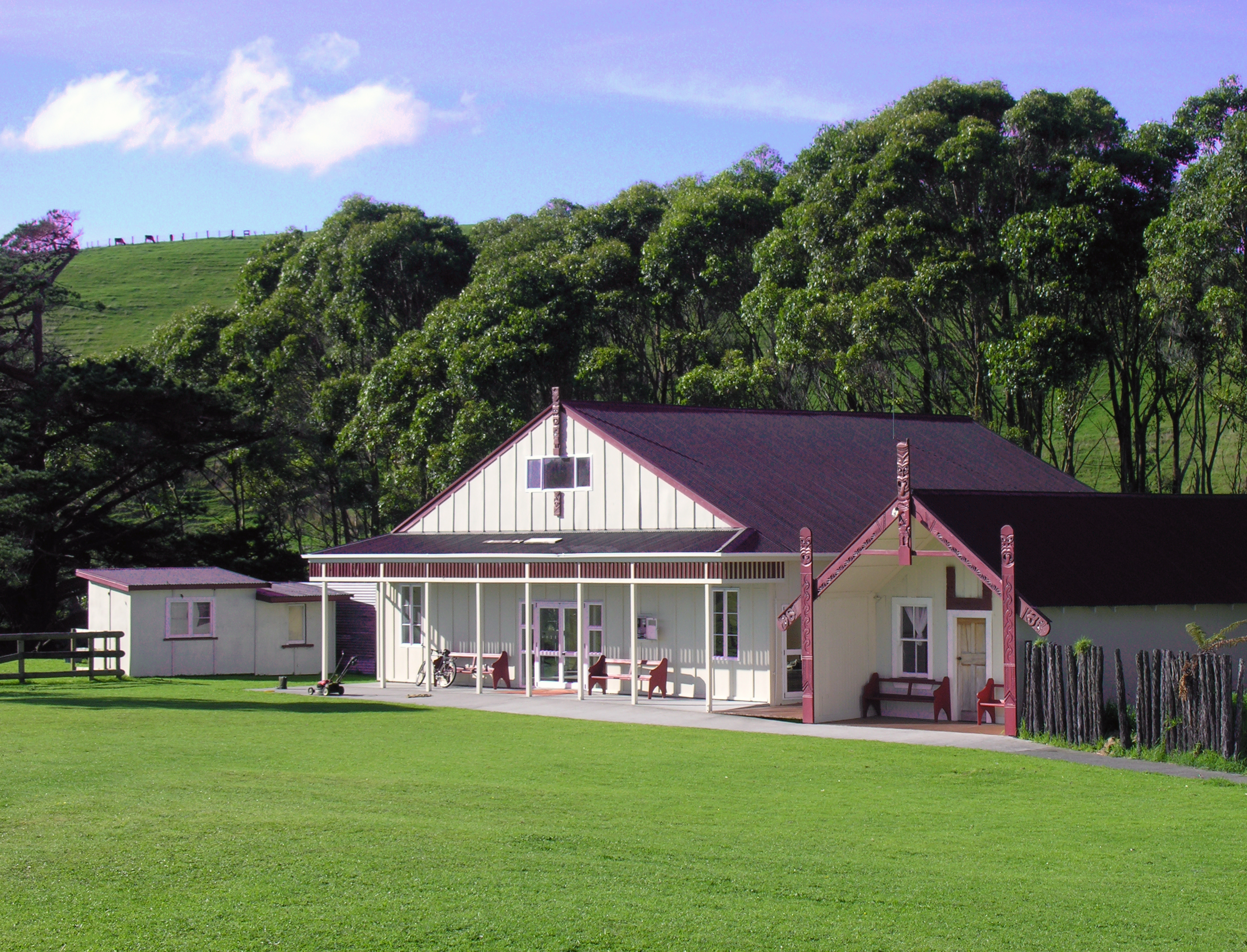
Whenuakura is a farming community on State Highway 3 east of Patea, at the southern end of Taranaki on the North Island of New Zealand. The boundary between the Taranaki and Wellington provinces runs through Whenuakura. There is the Whenuakura Primary School and Whenuakura Hall. Whenuakura is also bounded by the Patea and Whenuakura rivers. The population of the Whenuakura statistical area was 1,065 in the 2013 Census, an increase of 66 from 2006. The statistical area covers a large area to the northeast of Patea and not just the Whenuakura locality. The New Zealand golfer Michael Campbell, winner of the 2005 US Open, descends from these iwi. He spent his early childhood at Whenuakura and learned to play golf at the Patea Golf Club about 8 km to the west. Marae Whenuakura Pā near the Whenuakura River bridge is the pā marae of the Kairakau and Pamatangi hapū. Families at this pā descend from Nga Rauru, Ngati Ruanui or Ngāti Hine. All descend from Rangitawhi and Ao ... [...More Info...] [...Related Items...] OR: [Wikipedia] [Google] [Baidu] |
Whenuakura Marae, Taranaki, New Zealand
Whenuakura is a farming community on State Highway 3 east of Patea, at the southern end of Taranaki on the North Island of New Zealand. The boundary between the Taranaki and Wellington provinces runs through Whenuakura. There is the Whenuakura Primary School and Whenuakura Hall. Whenuakura is also bounded by the Patea and Whenuakura rivers. The population of the Whenuakura statistical area was 1,065 in the 2013 Census, an increase of 66 from 2006. The statistical area covers a large area to the northeast of Patea and not just the Whenuakura locality. The New Zealand golfer Michael Campbell, winner of the 2005 US Open, descends from these iwi. He spent his early childhood at Whenuakura and learned to play golf at the Patea Golf Club about 8 km to the west. Marae Whenuakura Pā near the Whenuakura River bridge is the pā marae of the Kairakau and Pamatangi hapū. Families at this pā descend from Nga Rauru, Ngati Ruanui or Ngāti Hine. All descend from Rangitawhi and Aot ... [...More Info...] [...Related Items...] OR: [Wikipedia] [Google] [Baidu] |
Patea
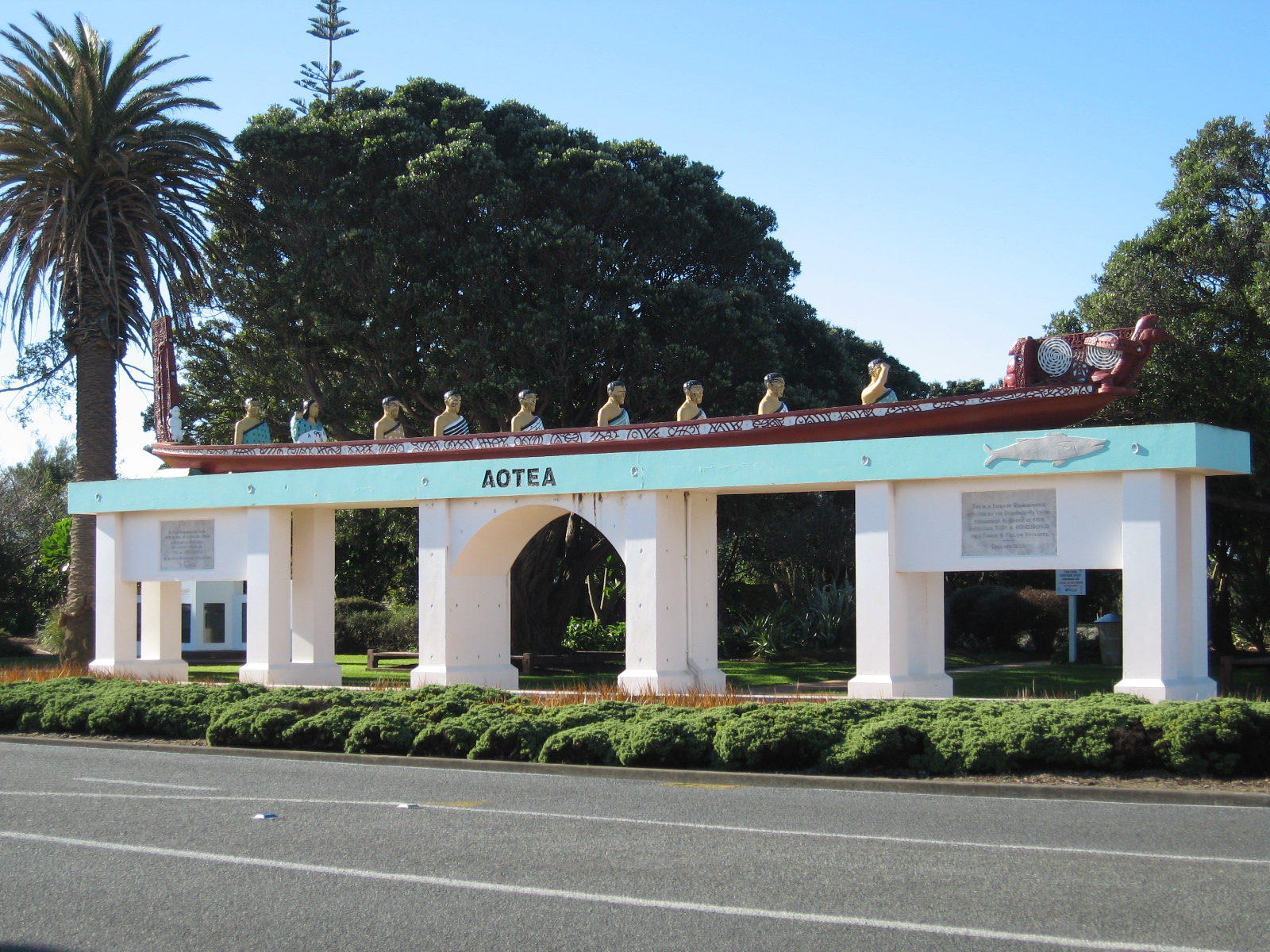
Patea ( ) is the third-largest town in South Taranaki District, New Zealand. It is on the western bank of the Pātea River, 61 kilometres north-west of Whanganui on . Hāwera is 27 km to the north-west, and Waverley 17 km to the east. The Pātea River flows through the town from the north-east and into the South Taranaki Bight. History and culture Pre-European history Patea is the traditional final place where some Māori led by Turi aboard the '' Aotea'' settled, after it was beached at the Aotea Harbour. European settlement Patea, called Carlyle or Carlyle Beach for a time by European settlers, was originally nearer the Pātea River mouth than the present town. During the New Zealand Wars Patea was an important military settlement. General Cameron's force arrived at the river mouth on 15 January 1865 and constructed redoubts on both sides of the river.South Taranaki District Council Heritage files (Local Government Historical Body) Patea became a market tow ... [...More Info...] [...Related Items...] OR: [Wikipedia] [Google] [Baidu] |
Patea River
Patea ( ) is the third-largest town in South Taranaki District, New Zealand. It is on the western bank of the Pātea River, 61 kilometres north-west of Whanganui on . Hāwera is 27 km to the north-west, and Waverley 17 km to the east. The Pātea River flows through the town from the north-east and into the South Taranaki Bight. History and culture Pre-European history Patea is the traditional final place where some Māori led by Turi aboard the '' Aotea'' settled, after it was beached at the Aotea Harbour. European settlement Patea, called Carlyle or Carlyle Beach for a time by European settlers, was originally nearer the Pātea River mouth than the present town. During the New Zealand Wars Patea was an important military settlement. General Cameron's force arrived at the river mouth on 15 January 1865 and constructed redoubts on both sides of the river.South Taranaki District Council Heritage files (Local Government Historical Body) Patea became a marke ... [...More Info...] [...Related Items...] OR: [Wikipedia] [Google] [Baidu] |
Michael Campbell
Michael Shane Campbell (born 23 February 1969) is a New Zealand professional golfer who is best known for having won the 2005 U.S. Open and, at the time, the richest prize in golf, the £1,000,000 HSBC World Match Play Championship, in the same year. He played on the European Tour and the PGA Tour of Australasia. Early life, amateur career Campbell was born in Hāwera, Taranaki. Ethnically, he is predominantly Māori, from the Ngāti Ruanui (father's side) and Ngā Rauru (mother's side) iwi. He also has some Scottish ancestry, being a great-great-great-grandson of John Logan Campbell, a Scottish emigrant to New Zealand. As a young child, he lived near his mother's Wai-o-Turi marae at Whenuakura, just south of Patea, and also spent much of his time with whanau at his father's Taiporohenui marae, near Hāwera. Like many young New Zealand boys, Campbell dreamed of playing for the All Blacks, and began playing rugby union, but his mother vetoed his participation. While he was ... [...More Info...] [...Related Items...] OR: [Wikipedia] [Google] [Baidu] |
Taranaki
Taranaki is a region in the west of New Zealand's North Island. It is named after its main geographical feature, the stratovolcano of Mount Taranaki, also known as Mount Egmont. The main centre is the city of New Plymouth. The New Plymouth District is home to more than 65 per cent of the population of Taranaki. New Plymouth is in North Taranaki along with Inglewood and Waitara. South Taranaki towns include Hāwera, Stratford, Eltham, and Ōpunake. Since 2005, Taranaki has used the promotional brand "Like no other". Geography Taranaki is on the west coast of the North Island, surrounding the volcanic peak of Mount Taranaki. The region covers an area of 7258 km2. Its large bays north-west and south-west of Cape Egmont are North Taranaki Bight and South Taranaki Bight. Mount Taranaki is the second highest mountain in the North Island, and the dominant geographical feature of the region. A Māori legend says that Mount Taranaki previously lived with the Tongariro ... [...More Info...] [...Related Items...] OR: [Wikipedia] [Google] [Baidu] |
Ngati Ruanui
''Ngati'' is a 1987 New Zealand feature film directed by Barry Barclay, written by Tama Poata and produced by John O'Shea. Production ''Ngati'' is of historical and cultural significance in New Zealand as it is the first feature film written and directed by Māori. Producer John O'Shea, an icon in New Zealand's film industry, was the founder of independent film company Pacific Films. The film is set in 1948 in a small town on the east coast of New Zealand during the impending closure of a freezing works and the threat of unemployment for the local community. ''Ngati'' was screened as part of Cannes' Critics Week. Synopsis Set in and around the fictional town of Kapua in 1948, Ngati is the story of a Māori community. The film comprises three narrative threads: a boy, Ropata, is dying of leukaemia; the return of a young Australian doctor, Greg, and his discovery that he has Māori heritage; and the fight to keep the local freezing works open. Unique in tone and quietly powerful ... [...More Info...] [...Related Items...] OR: [Wikipedia] [Google] [Baidu] |
Waka (canoe)
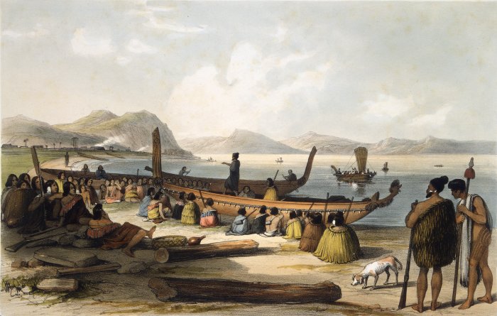
Waka () are Māori watercraft, usually canoes ranging in size from small, unornamented canoes (''waka tīwai'') used for fishing and river travel to large, decorated war canoes (''waka taua'') up to long. The earliest remains of a canoe in New Zealand were found near the Anaweka estuary in a remote part of the Tasman District and radiocarbon-dated to about 1400. The canoe was constructed in New Zealand, but was a sophisticated canoe, compatible with the style of other Polynesian voyaging canoes at that time. Since the 1970s about eight large double-hulled canoes of about 20 metres have been constructed for oceanic voyaging to other parts of the Pacific. They are made of a blend of modern and traditional materials, incorporating features from ancient Melanesia, as well as Polynesia. Waka taua (war canoes) ''Waka taua'' (in Māori, ''waka'' means "canoe" and '' taua'' means "army" or "war party") are large canoes manned by up to 80 paddlers and are up to in length. Large w ... [...More Info...] [...Related Items...] OR: [Wikipedia] [Google] [Baidu] |
Aotea (canoe)
In Māori tradition, ''Aotea'' is one of the canoes () in which Māori migrated to New Zealand; it is particularly associated with the tribes of Taranaki and Whanganui, including Ngāti Ruanui, Ngāruahine, Ngā Rauru and other tribal groups. History ''Aotea'' was a double canoe built by Toto from half of a great tree from Hawaiki, the other half being used for the canoe '' Matahourua''. Toto gave ''Aotea'' to his daughter Rongorongo, who was married to Turi. In strife with the chief Uenuku, Turi killed the chief's son and thereafter had to flee for New Zealand with 33 passengers. During the voyage, they stopped at Rangitahua and encountered some of the crew from the ''Kurahaupō'' canoe (Craig 1989:24). The ''Aotea'' canoe arrived at Aotea Harbour on the west coast of the North Island, and its people eventually settled in the Taranaki region. Aircraft 'Aotea' was the name given to the first Jumbo Jet (a Boeing 747-219B. Registration: ZK-NZV) acquired by Air New Zealand. ... [...More Info...] [...Related Items...] OR: [Wikipedia] [Google] [Baidu] |
Te Puni Kōkiri
Te Puni Kōkiri (TPK), the Ministry of Māori Development, is the principal policy advisor of the Government of New Zealand on Māori wellbeing and development. Te Puni Kōkiri was established under the Māori Development Act 1991 with responsibilities to promote Māori achievement in education, training and employment, health, and economic development; and monitor the provision of government services to Māori. The name means "a group moving forward together". History Protectorate Department (1840-1846) Te Puni Kōkiri, or the Ministry of Māori Development, traces its origins to the missionary-influenced Protectorate Department, which existed between 1840 and 1846. The Department was headed by the missionary and civil servant George Clarke, who held the position of Chief Protector. Its goal was to protect the rights of the Māori people in accordance with the Treaty of Waitangi. The Protectorate was also tasked with advising the Governor on matters relating to Māori and acti ... [...More Info...] [...Related Items...] OR: [Wikipedia] [Google] [Baidu] |
Ngāti Hine (Ngāti Ruanui)
Ngāti Hine is an iwi with a rohe in Northland, New Zealand. It is part of the wider Ngāpuhi iwi. Its rohe (tribal area) covers the areas of Waiomio, Kawakawa, Taumarere, Moerewa, Ruapekapeka, Motatau, Waimahae, Towai, Akeramaa, Pakaraka, Otiria, Pipiwai, Kaikou and Te Horo. History Ngāti Hine is descended from a female ancestor, Hineamaru, a great granddaughter of Rāhiri who settled in the Waiomio Valley, near Kawakawa. The prominent leader in the early years of European contact was Te Ruki Kawiti (1770s–1854). Ngāti Hine sought to withdraw from Te Runanga-a-Iwi o Ngapuhi charitable trust in 2010, without withdrawing from Ngāpuhi. Hapū and marae Marae The ''marae'' (communal places) of Ngāti Hine include: *Horomanga marae in Moerewa *Kaikou marae and Eparaima Makapi meeting house in Matawaia *Kawiti marae and Te Tawai Riri Maihi Kawiti meeting house in Waiomio *Matawaia marae and Rangimarie meeting house in Matawaia *Maungārongo marae and Maungārongo m ... [...More Info...] [...Related Items...] OR: [Wikipedia] [Google] [Baidu] |
2005 U
5 (five) is a number, numeral and digit. It is the natural number, and cardinal number, following 4 and preceding 6, and is a prime number. It has attained significance throughout history in part because typical humans have five digits on each hand. In mathematics 5 is the third smallest prime number, and the second super-prime. It is the first safe prime, the first good prime, the first balanced prime, and the first of three known Wilson primes. Five is the second Fermat prime and the third Mersenne prime exponent, as well as the third Catalan number, and the third Sophie Germain prime. Notably, 5 is equal to the sum of the ''only'' consecutive primes, 2 + 3, and is the only number that is part of more than one pair of twin primes, ( 3, 5) and (5, 7). It is also a sexy prime with the fifth prime number and first prime repunit, 11. Five is the third factorial prime, an alternating factorial, and an Eisenstein prime with no imaginary part and real part of ... [...More Info...] [...Related Items...] OR: [Wikipedia] [Google] [Baidu] |
Ngā Rauru
Ngā Rauru (also ''Ngā Rauru Kītahi'') is a Māori iwi in the South Taranaki region of New Zealand. In the 2006 census, 4,047 Māori claimed affiliation to Ngā Rauru, representing 12 hapu. History Early history The early history of Ngā Rauru kitahī starts before the coming of the Te Kāhui Rere, a Māori tribe that is situated in the South Taranaki area. The iwi takes its name from Rauru Kītahi, a Māori warrior who, after travelling extensively throughout New Zealand, settled in the south Taranaki region. Rauru Kītahi was the first son of Ruarangi and Rongoueroa (''see History of Te Āti Awa''), and a descendant of Toi-te-huatahi. Awanuiarangi, the founding ancestor of Te Āti Awa, was Rauru's half-brother. Tribal and land wars In the early 19th century, northern iwi including Ngā Puhi and Ngāti Toa fought other Māori iwi in campaigns throughout the North Island, armed with European muskets. Ngā Rauru came under attack from Ngāti Toa in 1822, and from Ngāti Tu ... [...More Info...] [...Related Items...] OR: [Wikipedia] [Google] [Baidu] |


.jpg)