|
Wenfordbridge
Wenfordbridge, or Wenford Bridge, is a hamlet some north of Bodmin and on the western flank of Bodmin Moor, in Cornwall, England, UK. It takes its name from an old granite bridge over the River Camel, and lies on the border between the parishes of St Breward and St Tudy. Wenford Bridge was the terminus of a former railway line from Wadebridge that was originally built by the Bodmin and Wadebridge Railway in 1834. The line was built in order to facilitate the transport of sea sand for agricultural use from the estuary of the Camel to the local farms, and never carried passengers. Other traffic included granite and china clay from local quarries, and the line survived to carry the latter until 1983. Today the route of the line forms part of the Camel Trail, a recreational route for walkers, cyclists and horse riders. Pottery The influential studio potter Michael Cardew purchased the inn at Wenford in 1939 and converted it to a pottery where he produced earthenware and stonewar ... [...More Info...] [...Related Items...] OR: [Wikipedia] [Google] [Baidu] |
Bodmin And Wadebridge Railway
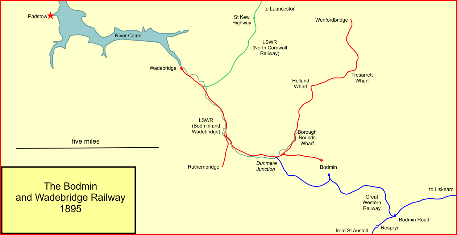
The Bodmin and Wadebridge Railway was a railway line opened in 1834 in Cornwall, England, United Kingdom. It linked the quays at Wadebridge with the town of Bodmin and also to quarries at Wenfordbridge.Sources use Wenfordbridge and Wenford Bridge interchangeably, but the current Ordnance Survey 1:50 000 maps cite the name as a single word Its intended traffic was minerals to the port at Wadebridge and sea sand, used to improve agricultural land, inwards. Passengers were also carried on part of the line. It was the first steam-powered railway line in the county and predated the main line to London by 25 years. It was always desperately short of money, both for initial construction and for actual operation. In 1847 it was purchased by the London and South Western Railway,Christopher Awdry, ''Encyclopaedia of British Railway Companies'', Patrick Stephens Limited, Wellingborough, 1990, when that company hoped to gain early access to Cornwall for its network, but in fact those intent ... [...More Info...] [...Related Items...] OR: [Wikipedia] [Google] [Baidu] |
Wenfordbridge - Geograph
Wenfordbridge, or Wenford Bridge, is a hamlet some north of Bodmin and on the western flank of Bodmin Moor, in Cornwall, England, UK. It takes its name from an old granite bridge over the River Camel, and lies on the border between the parishes of St Breward and St Tudy. Wenford Bridge was the terminus of a former railway line from Wadebridge that was originally built by the Bodmin and Wadebridge Railway in 1834. The line was built in order to facilitate the transport of sea sand for agricultural use from the estuary of the Camel to the local farms, and never carried passengers. Other traffic included granite and china clay from local quarries, and the line survived to carry the latter until 1983. Today the route of the line forms part of the Camel Trail, a recreational route for walkers, cyclists and horse riders. Pottery The influential studio potter Michael Cardew purchased the inn at Wenford in 1939 and converted it to a pottery where he produced earthenware and sto ... [...More Info...] [...Related Items...] OR: [Wikipedia] [Google] [Baidu] |
River Camel
The River Camel ( kw, Dowr Kammel, meaning ''crooked river'') is a river in Cornwall, England. It rises on the edge of Bodmin Moor and with its tributaries its catchment area covers much of North Cornwall. The river flows into the eastern Celtic Sea between Stepper Point and Pentire Point having covered about 30 miles, making it the second longest river wholly in Cornwall. The river is tidal upstream to Egloshayle and is popular for sailing, birdwatching and fishing. The name ''Camel'' comes from the Cornish language for 'the crooked one', a reference to its winding course. Historically the river was divided into three named stretches. Heyl ( kw, Heyl, meaning ''estuary'') was the name for the estuary up to Egloshayle, the River Allen ( kw, Dowr Alen, meaning ''shining river'') was the stretch between Egloshayle and Trecarne, whilst the Camel was reserved for the stretch of river between its source and Trecarne. Geology and hydrology The River Camel rises on Hendraburnick Do ... [...More Info...] [...Related Items...] OR: [Wikipedia] [Google] [Baidu] |
Wenford Bridge
Wenfordbridge, or Wenford Bridge, is a hamlet some north of Bodmin and on the western flank of Bodmin Moor, in Cornwall, England, UK. It takes its name from an old granite bridge over the River Camel, and lies on the border between the parishes of St Breward and St Tudy. Wenford Bridge was the terminus of a former railway line from Wadebridge that was originally built by the Bodmin and Wadebridge Railway in 1834. The line was built in order to facilitate the transport of sea sand for agricultural use from the estuary of the Camel to the local farms, and never carried passengers. Other traffic included granite and china clay from local quarries, and the line survived to carry the latter until 1983. Today the route of the line forms part of the Camel Trail, a recreational route for walkers, cyclists and horse riders. Pottery The influential studio potter Michael Cardew purchased the inn at Wenford in 1939 and converted it to a pottery where he produced earthenware and sto ... [...More Info...] [...Related Items...] OR: [Wikipedia] [Google] [Baidu] |
Camel Trail
The Camel Trail is a permissive cycleway in Cornwall, England, United Kingdom, that provides a recreational route for walkers, runners, cyclists and horse riders. The trail is flat (and suitable for disabled access); running from Padstow to Wenford Bridge via Wadebridge and Bodmin, it is long and used by an estimated 400,000 users each year generating an income of approximately £3 million a year. The trail is managed and maintained by Cornwall Council. Background history The trail follows the paths of two former rail lines: a section of the North Cornwall Railway between Padstow and Wadebridge and most of the Bodmin and Wadebridge Railway from Wadebridge to Wenford Bridge, along with a short branch from that line to Bodmin. The Bodmin and Wadebridge Railway was originally built at a cost of £35,000 following a study commissioned in 1831 by local landowner Sir William Molesworth of Pencarrow. The line was intended to carry sand from the Camel estuary to inland farms for use ... [...More Info...] [...Related Items...] OR: [Wikipedia] [Google] [Baidu] |
St Breward
St Breward ( kw, S. Bruwerd) is a civil parish and village in Cornwall, England, United Kingdom. It is on the western side of Bodmin Moor, about 6 miles (10 km) north of Bodmin. At the 2011 census the parish population including Cooksland and Fentonadle was 919. The parish name derives from Saint Branwalader. Until the 19th century it was commonly known by the corrupt form of the name: 'Simonward'. Local amenities The village has a footpath which travels in a loop past the holy well and the church. There is a shop & post office, a village hall, a football club (Brake Parc FC), a playground, a Methodist chapel, an Anglican church, a pub (The Old Inn) a war memorial hall and a primary school. Parish church The church is situated at the northern end of the village and is dedicated to St Branwalader (or Brueredus). It is a substantial building of the Norman period to which a south aisle and western tower were added in the 15th century (these additions are of granite). It wa ... [...More Info...] [...Related Items...] OR: [Wikipedia] [Google] [Baidu] |
Wadebridge
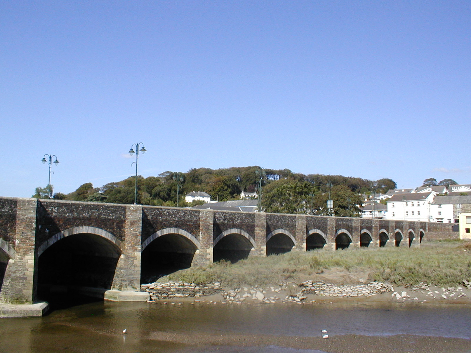
Wadebridge (; kw, Ponswad) is a town and civil parish in north Cornwall, England, United Kingdom. The town straddles the River Camel upstream from Padstow.Ordnance Survey: Landranger map sheet 200 ''Newquay & Bodmin'' The permanent population was 6,222 in the census of 2001, increasing to 7,900 in the 2011 census. There are two electoral wards in the town (East and West). Their total population is 8,272. Originally known as ''Wade'', it was a dangerous fording point across the river until a bridge was built here in the 15th century, after which the name changed to its present form. The bridge was strategically important during the English Civil War, and Oliver Cromwell went there to take it. Since then, it has been widened twice and refurbished in 1991. Wadebridge was served by a railway station between 1834 and 1967; part of the line now forms the Camel Trail, a recreational route for walkers, cyclists and horse riders. The town used to be a road traffic bottleneck on the ... [...More Info...] [...Related Items...] OR: [Wikipedia] [Google] [Baidu] |
Cornwall
Cornwall (; kw, Kernow ) is a historic county and ceremonial county in South West England. It is recognised as one of the Celtic nations, and is the homeland of the Cornish people. Cornwall is bordered to the north and west by the Atlantic Ocean, to the south by the English Channel, and to the east by the county of Devon, with the River Tamar forming the border between them. Cornwall forms the westernmost part of the South West Peninsula of the island of Great Britain. The southwesternmost point is Land's End and the southernmost Lizard Point. Cornwall has a population of and an area of . The county has been administered since 2009 by the unitary authority, Cornwall Council. The ceremonial county of Cornwall also includes the Isles of Scilly, which are administered separately. The administrative centre of Cornwall is Truro, its only city. Cornwall was formerly a Brythonic kingdom and subsequently a royal duchy. It is the cultural and ethnic origin of the Cornish dias ... [...More Info...] [...Related Items...] OR: [Wikipedia] [Google] [Baidu] |
St Tudy
St Tudy ( kw, Eglostudi) is a civil parish and village in north Cornwall, England, United Kingdom. The village is situated in the River Camel valley approximately five miles northeast of Wadebridge. History The village is mentioned as having a cattle fair in Owen's book of fairs 1788. During World War II, the US Army 60th Engineer Combat Battalion, part of the 35th Infantry Division were based at St Tudy prior to leaving for the Normandy landings via Southampton Docks. Notable houses There was formerly a manor house at Tinten and the chapel may still be recognised. It has been reused as a barn and has a 15th-century window. Other small former manor houses in the parish are Hengar, which was destroyed by a fire in 1904 (in 1906 it was rebuilt in Elizabethan style); Lamellen, Tremeer and Wetherham Lamellen has a garden with some very large rhododendrons and cryptomerias. Between 1941 and 1962 the garden became very overgrown but after 1962 a programme of reclamation began. The ... [...More Info...] [...Related Items...] OR: [Wikipedia] [Google] [Baidu] |
Railway
Rail transport (also known as train transport) is a means of transport that transfers passengers and goods on wheeled vehicles running on rails, which are incorporated in tracks. In contrast to road transport, where the vehicles run on a prepared flat surface, rail vehicles (rolling stock) are directionally guided by the tracks on which they run. Tracks usually consist of steel rails, installed on sleepers (ties) set in ballast, on which the rolling stock, usually fitted with metal wheels, moves. Other variations are also possible, such as "slab track", in which the rails are fastened to a concrete foundation resting on a prepared subsurface. Rolling stock in a rail transport system generally encounters lower frictional resistance than rubber-tyred road vehicles, so passenger and freight cars (carriages and wagons) can be coupled into longer trains. The operation is carried out by a railway company, providing transport between train stations or freight customer facilit ... [...More Info...] [...Related Items...] OR: [Wikipedia] [Google] [Baidu] |
Bodmin Moor
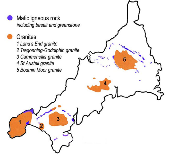
Bodmin Moor ( kw, Goon Brenn) is a granite moorland in north-eastern Cornwall, England. It is in size, and dates from the Carboniferous period of geological history. It includes Brown Willy, the highest point in Cornwall, and Rough Tor, a slightly lower peak. Many of Cornwall's rivers have their sources here. It has been inhabited since at least the Neolithic era, when primitive farmers started clearing trees and farming the land. They left their megalithic monuments, hut circles and cairns, and the Bronze Age culture that followed left further cairns, and more stone circles and stone rows. By medieval and modern times, nearly all the forest was gone and livestock rearing predominated. The name Bodmin Moor is relatively recent. An early mention is in the ''Royal Cornwall Gazette'' of 28 November 1812. The upland area was formerly known as Fowey Moor after the River Fowey, which rises within it. Geology Bodmin Moor is one of five granite plutons in Cornwall that make up pa ... [...More Info...] [...Related Items...] OR: [Wikipedia] [Google] [Baidu] |
Bodmin
Bodmin () is a town and civil parish in Cornwall, England, United Kingdom. It is situated south-west of Bodmin Moor. The extent of the civil parish corresponds fairly closely to that of the town so is mostly urban in character. It is bordered to the east by Cardinham parish, to the southeast by Lanhydrock parish, to the southwest and west by Lanivet parish, and to the north by Helland parish. Bodmin had a population of 14,736 as of the 2011 Census. It was formerly the county town of Cornwall until the Crown Courts moved to Truro which is also the administrative centre (before 1835 the county town was Launceston). Bodmin was in the administrative North Cornwall District until local government reorganisation in 2009 abolished the District (''see also Cornwall Council''). The town is part of the North Cornwall parliamentary constituency, which is represented by Scott Mann MP. Bodmin Town Council is made up of sixteen councillors who are elected to serve a term of four years. ... [...More Info...] [...Related Items...] OR: [Wikipedia] [Google] [Baidu] |


