|
Watcombe Bay
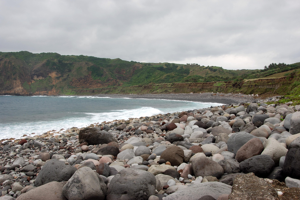
Watcombe Bay is a bay on the south west coast of the Isle of Wight, England. It lies just to the west of Freshwater Bay. It faces south towards the English Channel and is one of the smallest bays of the Isle of Wight. It is cut into the chalk cliff face of Highdown Cliffs. Its shoreline is less than 100m in length. Because of the steep cliffs it is only accessible by foot by scrambling round on the rocks from Freshwater Bay at low tide. The seabed is a mixture of mud, sand and shells. The beach is predominantly shingle The bay is best viewed from the cliff top on the Isle of Wight Coastal Path which passes by the bay. In the mid-19th century, a tunnel and steps led from the clifftop to the beach.image preceding p93, ''Brannon's Picture of the Isle of Wight'', George Brannon, c.1850Internet Archive brannonspictureo00bran/ref> A second tunnel, intended to connect the beach to the grounds of Redoubt House above, was commenced in the 1930s by EH Crinage. [...More Info...] [...Related Items...] OR: [Wikipedia] [Google] [Baidu] |
Isle Of Wight
The Isle of Wight ( ) is a county in the English Channel, off the coast of Hampshire, from which it is separated by the Solent. It is the largest and second-most populous island of England. Referred to as 'The Island' by residents, the Isle of Wight has resorts that have been popular holiday destinations since Victorian times. It is known for its mild climate, coastal scenery, and verdant landscape of fields, downland and chines. The island is historically part of Hampshire, and is designated a UNESCO Biosphere Reserve. The island has been home to the poets Algernon Charles Swinburne and Alfred, Lord Tennyson. Queen Victoria built her summer residence and final home, Osborne House at East Cowes, on the Isle. It has a maritime and industrial tradition of boat-building, sail-making, the manufacture of flying boats, hovercraft, and Britain's space rockets. The island hosts annual music festivals, including the Isle of Wight Festival, which in 1970 was the largest rock music ... [...More Info...] [...Related Items...] OR: [Wikipedia] [Google] [Baidu] |
England
England is a country that is part of the United Kingdom. It shares land borders with Wales to its west and Scotland to its north. The Irish Sea lies northwest and the Celtic Sea to the southwest. It is separated from continental Europe by the North Sea to the east and the English Channel to the south. The country covers five-eighths of the island of Great Britain, which lies in the North Atlantic, and includes over 100 smaller islands, such as the Isles of Scilly and the Isle of Wight. The area now called England was first inhabited by modern humans during the Upper Paleolithic period, but takes its name from the Angles, a Germanic tribe deriving its name from the Anglia peninsula, who settled during the 5th and 6th centuries. England became a unified state in the 10th century and has had a significant cultural and legal impact on the wider world since the Age of Discovery, which began during the 15th century. The English language, the Anglican Church, and Engli ... [...More Info...] [...Related Items...] OR: [Wikipedia] [Google] [Baidu] |
Freshwater, Isle Of Wight
Freshwater is a large village and civil parishes in England, civil parish at the western end of the Isle of Wight, England. The southern, coastal part of the village is Freshwater Bay, named for the adjacent small cove. Freshwater sits at the western end of the region known as the Back of the Wight or the West Wight, a popular tourist area. Freshwater is close to steep Chalk Formation, chalk cliffs. It was the birthplace of physicist Robert Hooke and was the home of Poet Laureate Alfred Tennyson, 1st Baron Tennyson, Alfred Lord Tennyson. Landmarks Freshwater is famous for its geology and coastal rock formations that have resulted from centuries worth of coastal erosion. The "Arch Rock" was a well-known local landmark that collapsed on 25 October 1992. The neighbouring "Stag Rock" is so named because supposedly a stag leapt to the rock from the cliff to escape during a hunt. Another huge slab fell off the cliff face in 1968, and is now known as the "Mermaid Rock". I ... [...More Info...] [...Related Items...] OR: [Wikipedia] [Google] [Baidu] |
English Channel
The English Channel, "The Sleeve"; nrf, la Maunche, "The Sleeve" (Cotentinais) or ( Jèrriais), (Guernésiais), "The Channel"; br, Mor Breizh, "Sea of Brittany"; cy, Môr Udd, "Lord's Sea"; kw, Mor Bretannek, "British Sea"; nl, Het Kanaal, "The Channel"; german: Ärmelkanal, "Sleeve Channel" ( French: ''la Manche;'' also called the British Channel or simply the Channel) is an arm of the Atlantic Ocean that separates Southern England from northern France. It links to the southern part of the North Sea by the Strait of Dover at its northeastern end. It is the busiest shipping area in the world. It is about long and varies in width from at its widest to at its narrowest in the Strait of Dover."English Channel". ''The Columbia Encyclopedia'', 2004. It is the smallest of the shallow seas around the continental shelf of Europe, covering an area of some . The Channel was a key factor in Britain becoming a naval superpower and has been utilised by Britain as a natural def ... [...More Info...] [...Related Items...] OR: [Wikipedia] [Google] [Baidu] |
Highdown Cliffs
Highdown may refer to: * Highdown Gardens, a garden in Worthing, England * Highdown Hill, a prominent hill in the South Downs, England * Highdown New Mill, Angmering Highdown New Mill or Ecclesden Mill is a tower mill at Angmering, Sussex, England which has been converted to residential accommodation. History ''Highdown New Mill'' was built in 1826. The mill was working until 1872. In 1880, the cap and sails ..., a tower mill in Sussex, England * Highdown School, an academy in Reading, Berkshire See also * High Down (other) {{disambig ... [...More Info...] [...Related Items...] OR: [Wikipedia] [Google] [Baidu] |
Shingle Beach
A shingle beach (also referred to as rocky beach or pebble beach) is a beach which is armoured with pebbles or small- to medium-sized cobbles (as opposed to fine sand). Typically, the stone composition may grade from characteristic sizes ranging from diameter. While this beach landform is most commonly found in Europe, examples are found in Bahrain, North America, and a number of other world regions, such as the west coast of New Zealand's South Island, where they are associated with the shingle fans of braided rivers. Though created at shorelines, post-glacial rebound can raise shingle beaches as high as above sea level, as on the High Coast in Sweden. The ecosystems formed by this unique association of rock and sand allow colonization by a variety of rare and endangered species. Formation Shingle beaches are typically steep, because the waves easily flow through the coarse, porous surface of the beach, decreasing the effect of backwash erosion and increasing the formati ... [...More Info...] [...Related Items...] OR: [Wikipedia] [Google] [Baidu] |
Isle Of Wight Coastal Path
The Isle of Wight Coastal Path (or Coastal Footpath) is a circular long-distance footpath of 70 miles (113 km) around the Isle of Wight, UK. It follows public footpaths and minor lanes, with some sections along roads. Route The path is waymarked in both directions and can be started at any point, but is described here clockwise from the pier at Ryde (). Ryde to Sandown Ryde to Bembridge (7.5 miles) From the bus station by Ryde Pier, the path follows the Esplanade close to the beach. It passes Appley Tower and Puckpool Point before rejoining the coast road to Seaview. It then climbs inland on footpaths, skirting Priory Woods, before returning to sea level at The Duver near St Helen's Old Church. Then the path crosses the edge of Bembridge Harbour on the old mill wall, using Embankment Road to pass the houseboats in the harbour. The path then continues into Bembridge and to the Lifeboat Station. Bembridge to Sandown (5.5 miles) The path follows the coa ... [...More Info...] [...Related Items...] OR: [Wikipedia] [Google] [Baidu] |
Freshwater Redoubt
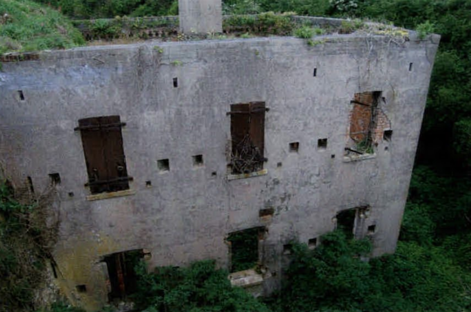
Freshwater Redoubt, also known as Fort Redoubt (map reference ) is an old Palmerston fort built in Freshwater Bay on the western end of the Isle of Wight. Construction work for the fort began in 1855 and was completed in 1856. It was finally sold in 1928 and has now been converted into a private residence. Army use Freshwater Redoubt is a Palmerston fort, completed in 1856 to defend Freshwater Bay, which was a possible landing beach for enemy troops. The deep, dry ditch protects the landward approaches. The Caponier building in the ditch served as barrack accommodation for 24 men. With its iron window-shutters and rifle slots the Caponier also provided a means of ditch defence. The original bridge had a section, which could be withdrawn, near the entrance gate, for defence purposes. The main building, visible through the gate, was originally a single storey, flat-roofed barrack comprising 3 Officers’ Rooms, an Officers’ Kitchen, Staff Sergeant's Quarters, and 2 rooms for 5 ... [...More Info...] [...Related Items...] OR: [Wikipedia] [Google] [Baidu] |
Scratchell's Bay
Scratchell's Bay is a bay on the south west coast of the Isle of Wight, England just to the south east of The Needles. It faces roughly south towards the English Channel, it is 250m in length and is straight. The name is thought to have come from one of the many names for the Devil. The beach which is made up mostly of shingle cannot be reached any other way than by boat, as there is no access from the top of the cliff. A small cave is located at the east end of the bay, near Sun Corner. The bay is best viewed from either the lookout point near the rocket launching facility or the Needles Old Battery National Trust property on the cliff top. The wreck of a 19th-century iron-hulled sailing ship called the lies within the bay. References {{Crossings navbox , structure = Around the Bays , place = Isle of Wight , bridge = Scratchell's Bay , bridge signs = , upstream text = North , upstream = Alum Bay Alum Bay is a bay near the westernmost point of the Isle of Wight, Engl ... [...More Info...] [...Related Items...] OR: [Wikipedia] [Google] [Baidu] |


