|
Vikramshila Setu
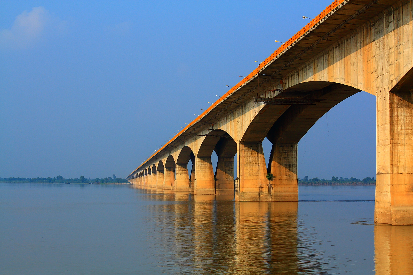
Vikramshila Setu is a bridge across the Ganges, near Bhagalpur in the Indian state of Bihar named after the ancient Mahavihara of Vikramashila which was established by King Dharmapala (783 to 820 A.D.) . Vikramshila Setu is 6th longest bridge over water in India. The 4.7 km long two lane bridge serves as a link between NH 33 and NH 31 running on the opposite sides of the Ganges. It runs from Barari Ghat on the Bhagalpur side on the south bank of the Ganges to Naugachia on the north bank. It also connects Bhagalpur to Purnia and Katihar. This has reduced considerably the road travel between Bhagalpur and places across the Ganges. However, there is intense traffic congestion on the bridge due to increased traffic and there is now a demand to construct another bridge parallel to it. On 21 September 2020 Prime Minister Mr Narendra Modi laid the foundation stone of another 4 lane road bridge of 4.445 km length over Ganga river parallel to Vikramshila Setu at cost of ... [...More Info...] [...Related Items...] OR: [Wikipedia] [Google] [Baidu] |
Bhagalpur
Bhagalpur is a city in the Indian state of Bihar, situated on the southern banks of the river Ganges. It is the 2nd largest city of Bihar by population and also the headquarters of Bhagalpur district and Bhagalpur division. Known as the Silk City, it is a major educational, commercial, and political center, and listed for development under the Smart City program, a joint venture between Government and industry. The Gangetic plains surrounding the city are very fertile and the main crops include rice, wheat, maize, barley, and oilseeds. The river is home to the Gangetic dolphin, the ''National Aquatic Animal of India'', and the Vikramshila Gangetic Dolphin Sanctuary is established near the town. The city holds the largest Manasa Puja and one of the largest processions in Kali Puja, an intangible cultural heritage of the region. Demography As of the 2011 India census, the Bhagalpur Urban Agglomeration has a population of 410,210, of which 218,284 were males and 191,926 were f ... [...More Info...] [...Related Items...] OR: [Wikipedia] [Google] [Baidu] |
Katihar
Katihar is a city situated in the eastern part of the state of Bihar in India. It is the regional headquarter of Katihar district. It is one of the important cities of Bihar. Also it's a main route of Delhi - Guwahati railway line. History Katihar is a part of the Mithila region. Mithila first gained prominence after being settled by Indo-Aryan peoples who established the Mithila Kingdom (also called Kingdom of the Videhas). During the late Vedic period (c. 1100–500 BCE), Kingdom of the Videhas became one of the major political and cultural centers of South Asia, along with Kuru and Pañcāla. The kings of the Kingdom of the Videhas were called Janakas. The Mithila Kingdom was later incorporated into the Vajjika League, which had its capital in the city of Vaishali, which is also in Mithila. Later it was dominated by Chaudhary family who were the biggest landlord of kosi commisionery and holds approx 15000 acre land in katihar district and 8500 acre in Purnia district. The ... [...More Info...] [...Related Items...] OR: [Wikipedia] [Google] [Baidu] |
Toll Bridges In India
Toll may refer to: Transportation * Toll (fee) a fee charged for the use of a road or waterway ** Road pricing, the modern practice of charging for road use ** Road toll (historic), the historic practice of charging for road use ** Shadow toll, payments made by government to the private sector operator of a road based on the number of vehicles using the road * Road toll (Australia and New Zealand), term for road death toll, i.e., the number of deaths caused annually by road accidents Brands and enterprises * Toll Brothers, Horsham Township, Pennsylvania based construction company founded by brothers Robert I. Toll and Bruce E. Toll * Toll Collect, a transportation support company in Germany * Toll Group, an Australian transportation company ** Toll Domestic Forwarding, an Australian freight forwarder ** Toll Ipec, Australian transportation company ** Toll Resources & Government Logistics Science * Toll (gene), encode members of the Toll-like receptor class of proteins * Toll-l ... [...More Info...] [...Related Items...] OR: [Wikipedia] [Google] [Baidu] |
Road Bridges In India
A road is a linear way for the conveyance of traffic that mostly has an improved surface for use by vehicles (motorized and non-motorized) and pedestrians. Unlike streets, the main function of roads is transportation. There are many types of roads, including parkways, avenues, controlled-access highways (freeways, motorways, and expressways), tollways, interstates, highways, thoroughfares, and local roads. The primary features of roads include lanes, sidewalks (pavement), roadways (carriageways), medians, shoulders, verges, bike paths (cycle paths), and shared-use paths. Definitions Historically many roads were simply recognizable routes without any formal construction or some maintenance. The Organization for Economic Co-operation and Development (OECD) defines a road as "a line of communication (travelled way) using a stabilized base other than rails or air strips open to public traffic, primarily for the use of road motor vehicles running on their own wheels", which i ... [...More Info...] [...Related Items...] OR: [Wikipedia] [Google] [Baidu] |
Tourist Attractions In Bihar
Tourism is travel for pleasure or business; also the theory and practice of touring, the business of attracting, accommodating, and entertaining tourists, and the business of operating tours. The World Tourism Organization defines tourism more generally, in terms which go "beyond the common perception of tourism as being limited to holiday activity only", as people "travelling to and staying in places outside their usual environment for not more than one consecutive year for leisure and not less than 24 hours, business and other purposes". Tourism can be domestic (within the traveller's own country) or international, and international tourism has both incoming and outgoing implications on a country's balance of payments. Tourism numbers declined as a result of a strong economic slowdown (the late-2000s recession) between the second half of 2008 and the end of 2009, and in consequence of the outbreak of the 2009 H1N1 influenza virus, but slowly recovered until the COVID-19 pa ... [...More Info...] [...Related Items...] OR: [Wikipedia] [Google] [Baidu] |
Bridges Over The Ganges
A bridge is a structure built to span a physical obstacle (such as a body of water, valley, road, or rail) without blocking the way underneath. It is constructed for the purpose of providing passage over the obstacle, which is usually something that is otherwise difficult or impossible to cross. There are many different designs of bridges, each serving a particular purpose and applicable to different situations. Designs of bridges vary depending on factors such as the function of the bridge, the nature of the terrain where the bridge is constructed and anchored, and the material used to make it, and the funds available to build it. The earliest bridges were likely made with fallen trees and stepping stones. The Neolithic people built boardwalk bridges across marshland. The Arkadiko Bridge (dating from the 13th century BC, in the Peloponnese) is one of the oldest arch bridges still in existence and use. Etymology The ''Oxford English Dictionary'' traces the origin of the wo ... [...More Info...] [...Related Items...] OR: [Wikipedia] [Google] [Baidu] |
Transport In Bhagalpur
Transport (in British English), or transportation (in American English), is the intentional movement of humans, animals, and goods from one location to another. Modes of transport include air, land (rail and road), water, cable, pipeline, and space. The field can be divided into infrastructure, vehicles, and operations. Transport enables human trade, which is essential for the development of civilizations. Transport infrastructure consists of both fixed installations, including roads, railways, airways, waterways, canals, and pipelines, and terminals such as airports, railway stations, bus stations, warehouses, trucking terminals, refueling depots (including fueling docks and fuel stations), and seaports. Terminals may be used both for interchange of passengers and cargo and for maintenance. Means of transport are any of the different kinds of transport facilities used to carry people or cargo. They may include vehicles, riding animals, and pack animals. Vehicles may inc ... [...More Info...] [...Related Items...] OR: [Wikipedia] [Google] [Baidu] |
List Of Longest Bridges Above Water In India
This is a list of India's bridges longer than , sorted by their full length above water. Bridges See also *List of longest bridges in the world *List of road–rail bridges *List of bridges in India *List of longest bridges in West Bengal References {{Reflist, 30em Length Bridges Bridges A bridge is a structure built to span a physical obstacle (such as a body of water, valley, road, or rail) without blocking the way underneath. It is constructed for the purpose of providing passage over the obstacle, which is usually someth ... Lists of construction records Indian superlatives Bridges in India by river Bridges, India ... [...More Info...] [...Related Items...] OR: [Wikipedia] [Google] [Baidu] |
List Of Longest Bridges In The World
This is a list of the world's longest bridges that are more than in length sorted by their full length above land and water. The main span is the longest span without any ground support. '' Note: There is no standard way to measure the total length of a bridge. Some bridges are measured from the beginning of the entrance ramp to the end of the exit ramp. Some are measured from shoreline to shoreline. Yet others use the length of the total construction involved in building the bridge. Since there is no standard, no ranking of a bridge should be assumed because of its position in the list. Additionally, numbers are merely estimates and measures in U.S. customary units (feet) may be imprecise due to conversion rounding.'' Completed Under construction See also * List of spans * List of longest arch bridge spans ** List of longest masonry arch bridge spans * List of longest cantilever bridge spans * List of longest cable-stayed bridge spans * List of longest continuous ... [...More Info...] [...Related Items...] OR: [Wikipedia] [Google] [Baidu] |
Bridges In Bihar
The state of Bihar has a number of bridges, extending from few metres to a few kilometres. The history of long bridges goes back to the British Empire when the site for the Koilwar bridge (Abdul Bari bridge) was surveyed in 1851. Since then a number of small and large bridges have crept up. Some are even largest of their kind. Mahatma Gandhi Setu, joining Patna and Hajipur was India's longest river bridge from 1982 to 2017. Notable bridges Mahatma Gandhi Setu Also called Gandhi Setu or Ganga Setu is a bridge over the river Ganges connecting Patna in the south to Hajipur in the north of Bihar. Its length is and it is one of the longest river bridges in India. It was inaugurated in May 1982 by the then Prime Minister, Indira Gandhi. The bridge was approved by the Central Government in 1969 and built by Gammon India Limited over a period of ten years, from 1972 to 1982. It was built to connect North Bihar with the rest of Bihar. Before this bridge was constructed, Rajendra Setu, ... [...More Info...] [...Related Items...] OR: [Wikipedia] [Google] [Baidu] |
Purnia
Purnia ()(also romanized as Purnea) is a city that serves as the administrative headquarters of both Purnia district and Purnia division in the Indian state of Bihar. Total geographical area of Purnia Urban Agglomeration is which is next only to Patna. Population density of the city is 3058 persons per km sq. making it the 4th largest city of Bihar by population. It is nearly 302 kilometres from Patna, as well as 171 km from Siliguri, 90 km from Bhagalpur.It is 640 km from Guwahati (Approx.) and 450 km from Kolkata, the capital of the adjacent state of West Bengal and the largest city in East India. Purnia district covers 3202.31 sq. km of the state of Bihar. The Indian Army, Indian Air Force, and three of five branches of India's Central Armed Police Forces – the Border Security Force (BSF), the Sashastra Seema Bal (SSB), and the Indo-Tibetan Border Police (ITBP) – have bases around the district. Etymology Several possible origins for the ... [...More Info...] [...Related Items...] OR: [Wikipedia] [Google] [Baidu] |
Ganges
The Ganges ( ) (in India: Ganga ( ); in Bangladesh: Padma ( )). "The Ganges Basin, known in India as the Ganga and in Bangladesh as the Padma, is an international river to which India, Bangladesh, Nepal and China are the riparian states." is a trans-boundary river of Asia which flows through India and Bangladesh. The river rises in the western Himalayas in the Indian state of Uttarakhand. It flows south and east through the Gangetic plain of North India, receiving the right-bank tributary, the Yamuna, which also rises in the western Indian Himalayas, and several left-bank tributaries from Nepal that account for the bulk of its flow. In West Bengal state, India, a feeder canal taking off from its right bank diverts 50% of its flow southwards, artificially connecting it to the Hooghly river. The Ganges continues into Bangladesh, its name changing to the Padma. It is then joined by the Jamuna, the lower stream of the Brahmaputra, and eventually the Meghna, forming the major ... [...More Info...] [...Related Items...] OR: [Wikipedia] [Google] [Baidu] |

_2014-07-24_22-55.jpg)


