|
Vasai
Vasai (Konkani and Marathi pronunciation: ő╔Ös╔Öi formerly and alternatively Mahratti; ''Bajipur'', English: Bassein; Portuguese: Ba├žaim), is a historical place and City near Mumbai (Bombay)'s western suburbs, located in Palghar district which was partitioned from the Thane district in 2014. It also forms a part of Vasai-Virar twin cities in the Konkan division of Maharashtra, India. The Portuguese in Goa and Damaon built the Vasai Fort to defend their colony and participate in the lucrative spice trade and the silk route that converged in the area. Much of Portuguese Bombay and Vasai was seized by Marathas during the period of Peshva rule, after the Battle of Vasai in 1739. The British East India Company then took over the territory from the Maratha Empire in 1780 during the First Anglo-Maratha War. Etymology The present name ''Vasai'' is derived from the Sanskrit word ''Waas'', meaning 'dwelling' or 'residence'. The name was changed to ''Basai'', which wa ... [...More Info...] [...Related Items...] OR: [Wikipedia] [Google] [Baidu] |
Vasai-Virar
Vasai-Virar is an agglomeration of four previously governed municipal councils i.e. Vasai, Virar, Nala Sopara, and Navghar-Manikpur and a few villages on the west as well as the east of the congested city area. It lies in the Konkan division of Maharashtra, India. The twin city of Vasai-Virar is a part of the Mumbai Metropolitan Region (MMR). According to the 2011 census, it is the 5th largest city in Maharashtra. Within a close proximity to Mumbai, it is located in Palghar district, Palghar District, & lies north of Vasai Creek and south of the Vaitarna, Vaitarna River. Vasai-Virar is bordered by Mira Bhayander, Mira-Bhayandar and Thane on its south and southeast, Bhiwandi-Nizampur Municipal Corporation, Bhiwandi-Nizampur on its east and Palghar rural district on its north. Vasai-Virar has several train stations. On the western line it has Naigaon, Vasai Road, Nala Sopara, Virar, and Vaitarna train stations, where as on the central line it has Juchandra and Kaman road stations. ... [...More Info...] [...Related Items...] OR: [Wikipedia] [Google] [Baidu] |
Vasai-Virar Municipal Corporation
Vasai-Virar City Municipal Corporation (VVCMC) is the civic body that governs areas and villages in Vasai-Virar taluka in Maharashtra, India comprising the most populated part of Palghar district. According to the 2011 census, it is the fifth largest city in Maharashtra with a population of more than 1.3 million. The city is located 50 km north of Mumbai, on the north bank of Vasai Creek, part of the estuary of the Ulhas River. It was formed on 3 July 2009 by combining four municipal councils and 53 ''gram panchayats''. City Areas & Towns under VVCMC *City under VVCMC: # Virar #Nalasopara # Vasai # Naigaon *Towns under VVMC: # Agashi # Bapne # Bhuigaon (BU) # Bhuigaon (KH) # Bilalpada # Bolinj # Chandansar # Chandeep # Chikhal Dongare # Chinchoti # Chobare # Dahisar # Dhaniv # Deodal # Gass # Gaskopari # Gavdhnee # Giriz # Gokhiware # Juchandra # Kaman # Kane # Khardi # Khardi # Karmale # Kasrali # Kashid Kopar # Kaular (BU) # Kaular (KH) # Kiravli # Kofrad # Kolhi ... [...More Info...] [...Related Items...] OR: [Wikipedia] [Google] [Baidu] |
Vasai Fort
Fort Vasai (Fortaleza de S├úo Sebasti├úo de Ba├ža├şm) is a ruined fort of the town of Vasai (Bassein), Maharashtra, India. The structure was formally christened as the Fort of St. Sebastian in the Indo-Portuguese era. The fort is a monument of national importance and is protected by the Archaeological Survey of India. The fort and the town are accessible via the Naigaon railway station, Naigaon Railway Station which itself is in the city of Vasai-Virar, and lies to the immediate north of the city of Mumbai. The Vasai Road railway station, Naigaon Railway Station is on the Western Railway zone, Western Railway line (formerly the Bombay, Baroda and Central India Railway, Bombay-Baroda railway) in the direction of the Virar railway station. History Pre-Portuguese Era The Ancient Greece, Greek merchant Cosma Indicopleustes is known to have visited the areas around Vasai in the 6th century and the Tang dynasty, Chinese traveller Xuanzang later on June or July 640. According ... [...More Info...] [...Related Items...] OR: [Wikipedia] [Google] [Baidu] |
Palghar District
Palghar District (Marathi pronunciation: a╦Él╔í╩▒╔Ö╔ż is a district in the state of Maharashtra in Konkan Division. On 1 Aug 2014, the State government of Maharashtra announced the formation of the 36th district of Maharashtra Palghar, it was partitioned out of the Thane district. Palghar District starts from Dahanu at the north and ends at Naigaon. It comprises the talukas of Palghar, Vada, Vikramgad, Jawhar, Mokhada, Dahanu, Talasari and Vasai. At the 2011 Census, the talukas now comprising the district had a population of 2,990,116. Palghar has an urban population of 1,435,210, that is 48% of total population is living in Urbanized Area. Palghar has all the three categories of the lifestyles, Urban (Nagari), Coastal (Sagari) and Mountains-Hilly Region (Dongari). Palghar District is blessed by beautiful beaches as it is the part of konkan such as "Shirgaon Beach", "Kelve Beach'', "Vadrai Beach", "Dahanu Beach", "Bordi Beach", "Chinchani Beach", "Arnala Beach", "Rajodi Be ... [...More Info...] [...Related Items...] OR: [Wikipedia] [Google] [Baidu] |
Vasai (Vidhan Sabha) Constituency
Vasai Assembly constituency is one of the 288 Vidhan Sabha (Legislative Assembly) constituencies of Maharashtra state in western India. Overview Vasai constituency is one of the six Vidhan Sabha constituencies located in the Palghar district. It is a non-reserved assembly constituency and part of Vasai taluka of the district. Vasai is part of the Palghar Lok Sabha constituency along with five other Vidhan Sabha segments, namely Dahanu, Vikramgad, Palghar, Boisar and Nalasopara in the Palghar district. Before delimitation, Vasai Assembly constituency was part of the Mumbai North (Lok Sabha constituency). Members of Legislative Assembly Election results 2019 results 2014 results 2009 results See also * Vasai * List of constituencies of Maharashtra Vidhan Sabha A ''list'' is any set of items in a row. List or lists may also refer to: People * List (surname) Organizations * List College, an undergraduate division of th ... [...More Info...] [...Related Items...] OR: [Wikipedia] [Google] [Baidu] |
Thana District
Thane district (Pronunciation: ł╩░a╦É╔│e previously named Taana or Thana) is a district in the Konkan Division of Maharashtra, India. At the 2011 Census it was the most populated district in the country, with 11,060,148 inhabitants; however, in August 2014 the district was split into two with the creation of a new Palghar district, leaving the reduced Thane district with a 2011 Census population of 8,070,032. The headquarters of the district is the city of Thane. Other major cities in the district are Navi Mumbai, Kalyan-Dombivli, Mira-Bhayander, Bhiwandi, Ulhasnagar, Ambarnath, Badlapur, Murbad and Shahapur. The district is situated between 18┬░42' and 20┬░20' north latitudes and 72┬░45' and 73┬░48' east longitudes. The revised area of the district is 4,214 km2. The district is bounded by Nashik district to the north east, Pune and Ahmednagar districts to the east, and by Palghar district to the north. The Arabian Sea forms the western boundary, while it is bounded by Mu ... [...More Info...] [...Related Items...] OR: [Wikipedia] [Google] [Baidu] |
Palghar
Palghar () is a town in the Konkan division of Maharashtra state, India and a municipal council. It is in the Mumbai Metropolitan Region, and since 2014 it has been the administrative capital of the Palghar district. Palghar lies on the Western Line of the Mumbai Suburban Railway in the busy Mumbai-Ahmedabad rail corridor. The town is located about 87 kilometers north of Mumbai, about 35 kilometers north of Virar and about 24 kilometers west of the Mumbai-Ahmedabad National Highway at Manor. History Palgar's history is alternate with its old district Thane. Jawhar, Vasai and Palghar tehsils have a historical legacy. Vasai (then known as Bassein) was under the Portuguese Empire. Chimaji Appa, the Maratha military commander later captured Vasai fort from the Portuguese and embedded the Maratha flag on Vasai. Palghar was one of the important points in 1942 of the Chalejav campaign. Demographics At the 2011 Census of India, Palghar had a population of 68,930. Males numbere ... [...More Info...] [...Related Items...] OR: [Wikipedia] [Google] [Baidu] |
Mumbai (Bombay)
Mumbai (, ; also known as Bombay ÔÇö List of renamed Indian cities and states#Maharashtra, the official name until 1995) is the capital city of the Indian States and union territories of India, state of Maharashtra and the ''de facto'' financial centre of India. According to the United Nations, as of 2018, Mumbai is the List of cities in India by population, second-most populous city in India after Delhi and the List of largest cities, eighth-most populous city in the world with a population of roughly 20 million (2 crore). As per the Indian government population census of 2011, Mumbai was the list of cities in India by population, most populous city in India with an estimated city proper population of 12.5 million (1.25 crore) living under the Municipal Corporation of Greater Mumbai, Brihanmumbai Municipal Corporation. Mumbai is the centre of the Mumbai Metropolitan Region, the sixth most populous metropolitan area in the world with a population of over 23 million ... [...More Info...] [...Related Items...] OR: [Wikipedia] [Google] [Baidu] |
Telephone Numbers In India
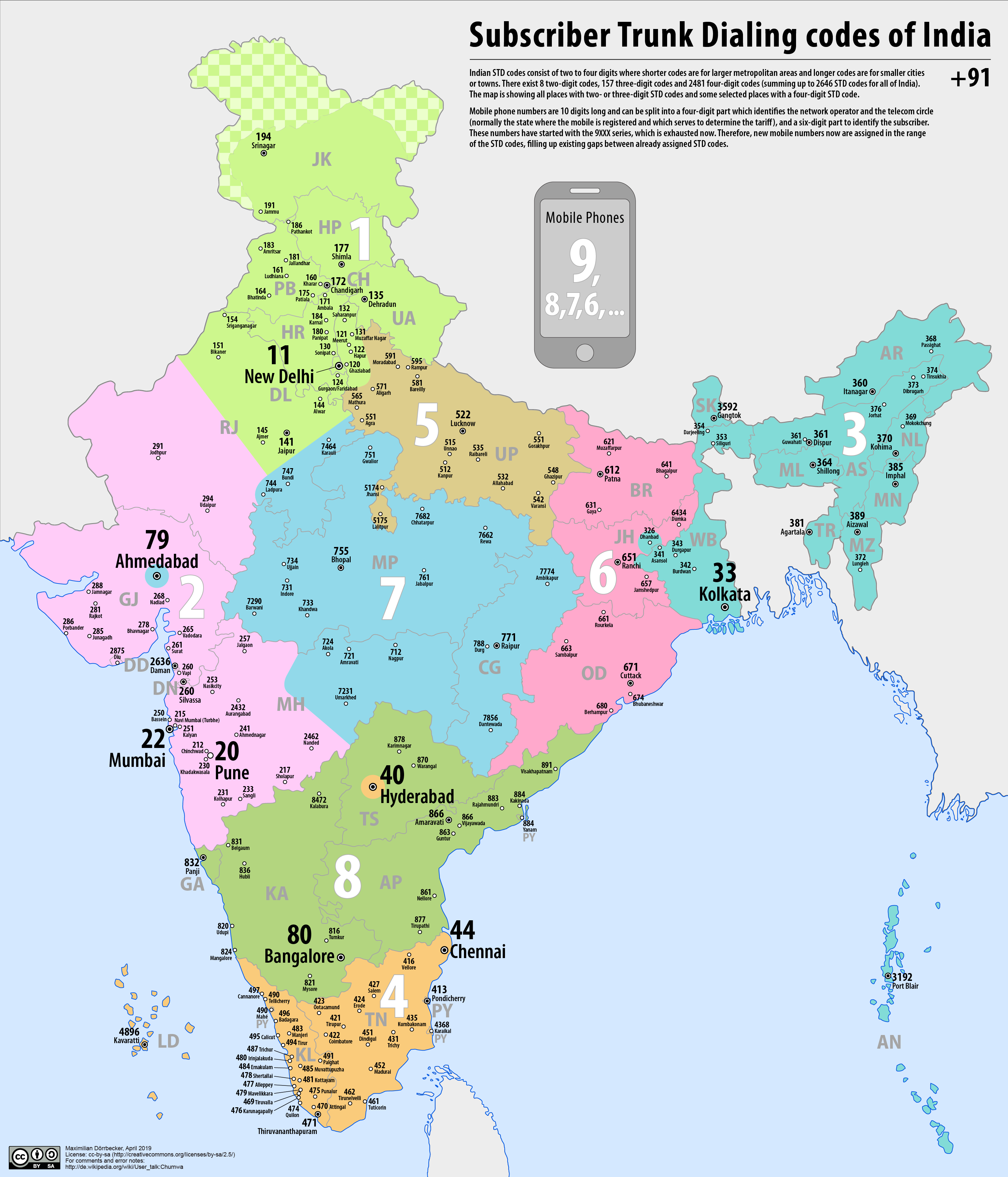
Telephone numbers in India are administered under the ''National Numbering Plan of 2003'' by the Department of Telecommunications of the Government of India. The numbering plan was last updated in 2015. The country code "91" was assigned to India by the International Telecommunication Union in the 1960s. Fixed-line (landline) numbers Subscriber trunk dialling (STD) codes are assigned to each city, town and village. These codes can be between 2 and 8 digits long, with the largest metropolitan areas and cities having the shortest (two-digit) codes: *11 - New Delhi, Delhi *22 - Mumbai, Maharashtra *33 - Kolkata, West Bengal *44 - Chennai, Tamil Nadu *20 - Pune, Maharashtra *40 - Hyderabad, Telangana *79 - Ahmedabad, Gujarat *80 - Bengaluru, Karnataka Second-tier cities and metropolitan areas, as well as large or particularly significant towns have three-digit area codes: *120 - Ghaziabad and Noida, Uttar Pradesh *124 - Gurugram, Haryana *129 - Faridabad, ... [...More Info...] [...Related Items...] OR: [Wikipedia] [Google] [Baidu] |
Phudagi Language
The Phudagi language, also known as Vadvali, is a language or dialect of the MarathiÔÇôKonkani group. This language is spoken by Panchkalshi and Chaukalshi communities residing in Palghar, Vasai Vasai (Konkani and Marathi pronunciation: ő╔Ös╔Öi formerly and alternatively Mahratti; ''Bajipur'', English: Bassein; Portuguese: Ba├žaim), is a historical place and City near Mumbai (Bombay)'s western suburbs, located in Palghar district w ... localities. References {{Indo-Aryan languages Konkani languages Southern Indo-Aryan languages ... [...More Info...] [...Related Items...] OR: [Wikipedia] [Google] [Baidu] |
Kadodi Language
Kadodi, Samavedi is the language spoken by the Samvedi Brahmin and Kupari community in Vasai, Maharashtra Maharashtra (; , abbr. MH or Maha) is a states and union territories of India, state in the western India, western peninsular region of India occupying a substantial portion of the Deccan Plateau. Maharashtra is the List of states and union te ..., India. See also * List of Kadodi words and Kadodi to Marathi word meanings References Southern Indo-Aryan languages Culture of Maharashtra Konkani languages {{IndoAryan-lang-stub ... [...More Info...] [...Related Items...] OR: [Wikipedia] [Google] [Baidu] |
Konkani People
The Konkan people ( Konkani) Konkanis The Konkan people (Konkani language, Konkani) Konkanis The Konkan people (Konkani language, Konkani) Konkanis The Konkan people (Konkani language, Konkani) Konkanis The Konkan people (Konkani language, Konkani) Konkanis The Konkan people (Konkani language, Konkani) Konkanis The Konkan people (Konkani language, Konkani) Konkanis The Konkan people (Konkani language, Konkani) Konkanis The Konkan people (Konkani language, Konkani) Konkanis The Konkan people (Konkani language, Konkani) Konkanis The Konkan people (Konkani language, Konkani) Konkanis The Konkan people (Konkani language, Konkani) Konkanis The Konkan people (Konkani language, Konkani) Konkanis The Konkan people (Konkani language, Konkani) Konkanis The Konkan people (Konkani language, Konkani) Konkanis The Konkan people (Konkani language, Konkani) Konkanis The Konkan people ... [...More Info...] [...Related Items...] OR: [Wikipedia] [Google] [Baidu] |
.jpg)


