|
Vorderasiatisches Museum
The Vorderasiatisches Museum (, '' Near East Museum'') is an archaeological museum in Berlin. It is in the basement of the south wing of the Pergamon Museum and has one of the world's largest collections of Southwest Asian art. 14 halls distributed across 2,000 square meters of exhibition surface display southwest Asian culture spanning six millennia. The exhibits cover a period from the 6th millennium BCE into the time of the Muslim conquests. They originate particularly from today's states of Iraq, Syria and Turkey, with singular finds also from other areas. Starting with the Neolithic finds, the emphasis of the collection is of finds from Sumer, Babylonia and Assyria, as well as northern Syria and eastern Anatolia. Excavations in historically important cities like Uruk, Shuruppak, Assur, Hattusha, Tell el Amarna, Tell Halaf (Guzana), Sam'al, Toprakkale and Babylon built the foundation of the museum's collection. Further acquisitions came from Nimrud, Nineveh, Susa ... [...More Info...] [...Related Items...] OR: [Wikipedia] [Google] [Baidu] |
Pergamonmuseum Ishtartor 08
The Pergamon Museum (; ) is a listed building on the Museum Island in the historic centre of Berlin. It was built from 1910 to 1930 by order of German Emperor Wilhelm II according to plans by Alfred Messel and Ludwig Hoffmann in Stripped Classicism style. Landesdenkmalamt Berlin As part of the Museum Island complex, the Pergamon Museum was inscribed on the in 1999 because of its architecture and testimony to the evolution of museums as architectural and social phenomena.< ... [...More Info...] [...Related Items...] OR: [Wikipedia] [Google] [Baidu] |
Shuruppak
Shuruppak ( sux, , "the healing place"), modern Tell Fara, was an ancient Sumerian city situated about 55 kilometres (35 mi) south of Nippur on the banks of the Euphrates in Iraq's Al-Qādisiyyah Governorate. Shuruppak was dedicated to Ninlil, also called Sud, the goddess of grain and the air. Shuruppak and its environment Shuruppak is located in Al-Qādisiyyah Governorate, approximately 55 kilometres (35 mi) south of Nippur. The site of extends about a kilometer from north to south. The total area is about 120 hectares, with about 35 hectares of the mound being more than 3 meters above the surrounding plain, with a maximum of 9 meters. Archaeology After a brief survey by Hermann Volrath Hilprecht in 1900, it was first excavated in 1902 by Robert Koldewey and Friedrich Delitzsch of the German Oriental Society for eight months. Among other finds, hundreds of Early Dynastic tablets were collected, which ended up in the Berlin Museum and the Istanbul Museum. In Ma ... [...More Info...] [...Related Items...] OR: [Wikipedia] [Google] [Baidu] |
Akkadian Empire
The Akkadian Empire () was the first ancient empire of Mesopotamia after the long-lived civilization of Sumer. It was centered in the city of Akkad (city), Akkad () and its surrounding region. The empire united Akkadian language, Akkadian and Sumerian language, Sumerian speakers under one rule. The Akkadian Empire exercised influence across Mesopotamia, the Levant, and Anatolia, sending military expeditions as far south as Dilmun and Magan (civilization), Magan (modern Saudi Arabia, Bahrain, and Oman) in the Arabian Peninsula.Mish, Frederick C., Editor in Chief. "Akkad" ''Webster’s Ninth New Collegiate Dictionary''. ninth ed. Springfield, MA: Merriam-Webster 1985. ). The Akkadian Empire reached its political peak between the 24th and 22nd centuries BC, following the conquests by its founder Sargon of Akkad. Under Sargon and his successors, the Akkadian language was briefly imposed on neighboring conquered states such as Elam and Gutian people, Gutium. Akkad is sometimes regar ... [...More Info...] [...Related Items...] OR: [Wikipedia] [Google] [Baidu] |
Persepolis
, native_name_lang = , alternate_name = , image = Gate of All Nations, Persepolis.jpg , image_size = , alt = , caption = Ruins of the Gate of All Nations, Persepolis. , map = , map_type = Iran#West Asia , map_alt = , map_caption = , map_size = , altitude_m = , altitude_ref = , relief = yes , coordinates = , map_dot_label = , location = Marvdasht, Fars Province, Iran , region = , type = Settlement , part_of = , length = , width = , area = , volume = , diameter = , circumference = , height = , builder = , and , material = Limestone, mud-brick, cedar wood , built = 6th century BC , abandoned = , epochs = Achaemenid Empire , cultures = Persian , dependency_of = , occupants = , event = * Battle of the Pe ... [...More Info...] [...Related Items...] OR: [Wikipedia] [Google] [Baidu] |
Susa
Susa ( ; Middle elx, 𒀸𒋗𒊺𒂗, translit=Šušen; Middle and Neo- elx, 𒋢𒋢𒌦, translit=Šušun; Neo-Elamite and Achaemenid elx, 𒀸𒋗𒐼𒀭, translit=Šušán; Achaemenid elx, 𒀸𒋗𒐼, translit=Šušá; fa, شوش ; he, שׁוּשָׁן ; grc-gre, Σοῦσα ; syr, ܫܘܫ ; pal, 𐭮𐭥𐭱𐭩 or ; peo, 𐏂𐎢𐏁𐎠 ) was an ancient city in the lower Zagros Mountains about east of the Tigris, between the Karkheh and Dez Rivers in Iran. One of the most important cities of the Ancient Near East, Susa served as the capital of Elam and the Achaemenid Empire, and remained a strategic centre during the Parthian and Sasanian periods. The site currently consists of three archaeological mounds, covering an area of around one square kilometre. The modern Iranian town of Shush is located on the site of ancient Susa. Shush is identified as Shushan, mentioned in the Book of Esther and other Biblical books. Name The English name is derived ... [...More Info...] [...Related Items...] OR: [Wikipedia] [Google] [Baidu] |
Nineveh
Nineveh (; akk, ; Biblical Hebrew: '; ar, نَيْنَوَىٰ '; syr, ܢܝܼܢܘܹܐ, Nīnwē) was an ancient Assyrian city of Upper Mesopotamia, located in the modern-day city of Mosul in northern Iraq. It is located on the eastern bank of the Tigris River and was the capital and largest city of the Neo-Assyrian Empire, as well as the largest city in the world for several decades. Today, it is a common name for the half of Mosul that lies on the eastern bank of the Tigris, and the country's Nineveh Governorate takes its name from it. It was the largest city in the world for approximately fifty years until the year 612 BC when, after a bitter period of civil war in Assyria, it was sacked by a coalition of its former subject peoples including the Babylonians, Medes, Persians, Scythians and Cimmerians. The city was never again a political or administrative centre, but by Late Antiquity it was the seat of a Christian bishop. It declined relative to Mosul during the Middle ... [...More Info...] [...Related Items...] OR: [Wikipedia] [Google] [Baidu] |
Nimrud
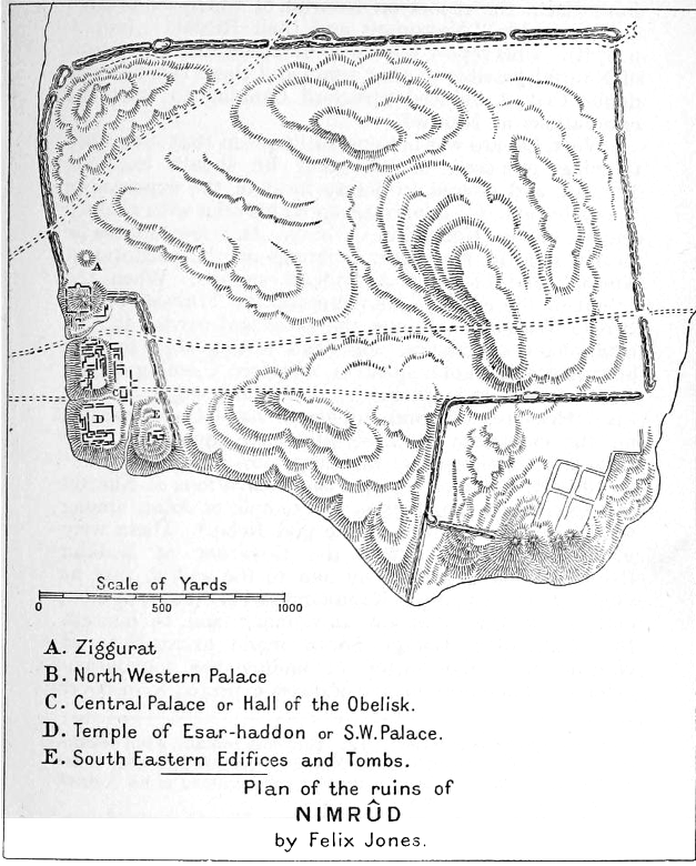
Nimrud (; syr, ܢܢܡܪܕ ar, النمرود) is an ancient Assyrian city located in Iraq, south of the city of Mosul, and south of the village of Selamiyah ( ar, السلامية), in the Nineveh Plains in Upper Mesopotamia. It was a major Assyrian city between approximately 1350 BC and 610 BC. The city is located in a strategic position north of the point that the river Tigris meets its tributary the Great Zab.Brill's Encyclopedia of Islam 1913-36 p.923 The city covered an area of . The ruins of the city were found within of the modern-day village of |
Babylon
''Bābili(m)'' * sux, 𒆍𒀭𒊏𒆠 * arc, 𐡁𐡁𐡋 ''Bāḇel'' * syc, ܒܒܠ ''Bāḇel'' * grc-gre, Βαβυλών ''Babylṓn'' * he, בָּבֶל ''Bāvel'' * peo, 𐎲𐎠𐎲𐎡𐎽𐎢 ''Bābiru'' * elx, 𒀸𒁀𒉿𒇷 ''Babili'' *Kassite: ''Karanduniash'', ''Karduniash'' , image = Street in Babylon.jpg , image_size=250px , alt = A partial view of the ruins of Babylon , caption = A partial view of the ruins of Babylon , map_type = Near East#West Asia#Iraq , relief = yes , map_alt = Babylon lies in the center of Iraq , coordinates = , location = Hillah, Babil Governorate, Iraq , region = Mesopotamia , type = Settlement , part_of = Babylonia , length = , width = , area = , height = , builder = , material = , built = , abandoned = , epochs = , cultures = Sumerian, Akkadian, Amorite, Kassite, Assyrian, Chaldean, Achaemenid, Hellenistic, Parthian, Sasanian, Muslim , dependency_of = , occupants = , event = , excavations = , archaeologists = Hormuzd Rassam, Robe ... [...More Info...] [...Related Items...] OR: [Wikipedia] [Google] [Baidu] |
Toprakkale (castle)
Rusahinili ("city of (King) Rusa I)", modern Toprakkale (Turkey), is an ancient Urartian fortress built by Rusa I, located near the modern city of Van in eastern Turkey. The site has been excavated by archaeological teams from Germany, the United Kingdom The United Kingdom of Great Britain and Northern Ireland, commonly known as the United Kingdom (UK) or Britain, is a country in Europe, off the north-western coast of the continental mainland. It comprises England, Scotland, Wales and North ..., and other countries. External linksToprakkale - Encyclopædia Britannica Article Archaeological sites in Eastern Anatolia Van Province Urartian cities Castles in Van Province {{Armenia-hist-stub ... [...More Info...] [...Related Items...] OR: [Wikipedia] [Google] [Baidu] |
Guzana
Tell Halaf ( ar, تل حلف) is an archaeological site in the Al Hasakah governorate of northeastern Syria, a few kilometers from the city of Ra's al-'Ayn near the Turkish border. The site, which dates to the 6th millennium BCE, was the first to be excavated from a Neolithic culture, later called the Halaf culture, characterized by glazed pottery painted with geometric and animal designs. In the Bronze Age it was a Hittite ruling city, and then in the 10th century BCE the location of the Aramaean city-state of Guzana or Gozan. By the end of the 9th century it was a famous Aramean city-state. The many finds of monumental sculpture removed to various museums around the world mostly date from the later periods. Discovery and excavations The site is located near the city of Ra's al-'Ayn in the fertile valley of the Khabur River (Nahr al-Khabur), close to the modern border with Turkey. The name ''Tell Halaf'' is a local Aramaic placename, '' tell'' meaning "hill", and '' ... [...More Info...] [...Related Items...] OR: [Wikipedia] [Google] [Baidu] |
Tell Halaf
Tell Halaf ( ar, تل حلف) is an archaeological site in the Al Hasakah governorate of northeastern Syria, a few kilometers from the city of Ra's al-'Ayn near the Turkish border. The site, which dates to the 6th millennium BCE, was the first to be excavated from a Neolithic culture, later called the Halaf culture, characterized by glazed pottery painted with geometric and animal designs. In the Bronze Age it was a Hittite ruling city, and then in the 10th century BCE the location of the Aramaean city-state of Guzana or Gozan. By the end of the 9th century it was a famous Aramean city-state. The many finds of monumental sculpture removed to various museums around the world mostly date from the later periods. Discovery and excavations The site is located near the city of Ra's al-'Ayn in the fertile valley of the Khabur River (Nahr al-Khabur), close to the modern border with Turkey. The name ''Tell Halaf'' is a local Aramaic placename, '' tell'' meaning "hill", and ' ... [...More Info...] [...Related Items...] OR: [Wikipedia] [Google] [Baidu] |

.png)


