|
Vihdintie
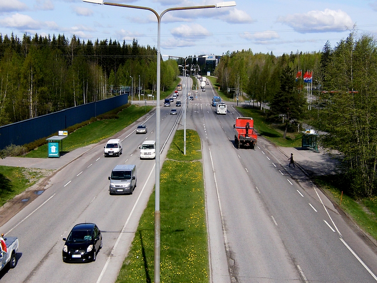
Finnish regional road 120 ( fi, Seututie 120, sv, Regionalväg 120), or Vihti Road ( fi, Vihdintie, sv, Vichtisvägen), is a regional road from Haaga in Helsinki to Maikkala in Vihti. The road is part of the former Pori Highway. Regional road 120 was originally intended as the main road connection from Helsinki to Pori via the Vihti church village, but when it was completed, the road was already prone to accidents due to its complexity, hilliness and narrowness. However, the Helsinki-side section of the road up to Ring III has later been widened to four lanes, but the beginning of Vihdintie in Etelä-Haaga from Mannerheimintie to Haaga roundabout is street-like. The regional road also passes Highway 25 at the village of Otalampi. Significant commercial centers along Vihdintie include the Ristikko Shopping Centre in the Konala district. [...More Info...] [...Related Items...] OR: [Wikipedia] [Google] [Baidu] |
Konala
Konala (Finnish), Kånala (Swedish) is a subdistrict of Helsinki, Finland. Konala has about 4500 inhabitants and about 3000 jobs. Konala is situated in north-western Helsinki, north of Ring I road and Pitäjänmäki, west of Malminkartano and Kannelmäki. It is bordered from the south by Ring I, east by green zone which separates at the industrial area along Vihdintie and the west at Espoo's border. The houses are mainly small apartment houses and townhouses. The area also contains industrial and commercial enterprises. Vihdintie has several automotive companies. Konala-seura estimated that Konala is considered a safe place to live. The Ristikko Shopping Centre, which opened in 2015, is also located in Konala. Konalantie splits Konala into two different parts. On the east side of Konalantie, there are regional blocks of industry, business and apartment blocks. On the west side of the road, there are quieter terraced houses. An excellent example of this is Äestäjäntien houses. K ... [...More Info...] [...Related Items...] OR: [Wikipedia] [Google] [Baidu] |
Ring III
Kehä III (''"ring three"'', ''National road 50''; or fi, Kehä III or ; or ) is an important highway in Southern Finland. It is the outermost of the three beltways in the Helsinki region, and the first one to be built. It lies across the four Finnish municipalities of Kirkkonummi, Espoo, Vantaa and Helsinki. Shaped like an arch, the road is long, of which only a very small fraction passes within the borders of Helsinki itself. Overview Work on Kehä III started in 1962, on the base of an existing road. The construction was finished in 1972, initially with only one lane per direction. Most parts of the road have since been expanded to at least two lanes per direction, although the westernmost end is still one-lane per direction in places. The most recent construction work has been extensive renovation on its busiest stretch in Vantaa, where several interchanges have been built or improved, and lanes added. Industrial development along the road has introduced higher volume ... [...More Info...] [...Related Items...] OR: [Wikipedia] [Google] [Baidu] |
Helsinki
Helsinki ( or ; ; sv, Helsingfors, ) is the Capital city, capital, primate city, primate, and List of cities and towns in Finland, most populous city of Finland. Located on the shore of the Gulf of Finland, it is the seat of the region of Uusimaa in southern Finland, and has a population of . The Helsinki urban area, city's urban area has a population of , making it by far the List of urban areas in Finland by population, most populous urban area in Finland as well as the country's most important center for politics, education, finance, culture, and research; while Tampere in the Pirkanmaa region, located to the north from Helsinki, is the second largest urban area in Finland. Helsinki is located north of Tallinn, Estonia, east of Stockholm, Sweden, and west of Saint Petersburg, Russia. It has History of Helsinki, close historical ties with these three cities. Together with the cities of Espoo, Vantaa, and Kauniainen (and surrounding commuter towns, including the eastern ... [...More Info...] [...Related Items...] OR: [Wikipedia] [Google] [Baidu] |
Turuntie
Finnish regional road 110 ( fi, Seututie 110, sv, Regionalväg 110), or Turku Road ( fi, Turuntie, sv, Åbosvägen), is the leading regional road from Helsinki to Turku. The road is a parallel to the former Highway 1 and the current Highway 1 ( E18). Regional road 110 actually starts at the Haaga roundabout. In it, it differs from regional road 120, or Vihdintie, which again starts at the northern end of Mannerheimintie. The road runs from Helsinki through Veikkola to Saukkola and Nummenkylä in Lohja and from there through Salo's Kitula, Muurla and the center of Salo to Kupittaa Kupittaa ( sv, Kuppis) is a district in Turku, Finland. It is located on the eastern side of the city's centre, around the Kupittaa Park, the first landscaped park in a Finnish city. The district serves as a centre for recreation and business. ... in Turku. The alignment of the road partly follows the old king's road. References External links Roads in Finland Transport in Helsinki T ... [...More Info...] [...Related Items...] OR: [Wikipedia] [Google] [Baidu] |
Lopentie
Finnish regional road 132 ( fi, Seututie 132, sv, Regionalväg 132), or Loppi Road ( fi, Lopentie, sv, Loppisvägen) is the road between Finnish national road 3, Highway 3 (European route E12, E12) and Finnish national road 54, Highway 54, which starts at the southern end from the border of Vantaa and Nurmijärvi and at the northern end starts in the municipality of Loppi, right next to the Loppi (village), church village of Loppi. The road is paved, dual lane and 52 miles long. Back in the late 1950s, it was the original main road before the current freeway, and in addition to passing through Loppi, it continued through the remote forest areas of Janakkala all the way to Hämeenlinna. And before the completion of the current Finnish national road 2, it also served the traffic of Forssa and Pori, which passed through Loppi and Tammela, Finland, Tammela. In November 2020, a new road alignment was completed on the road around the northern part of Nurmijärvi's Klaukkala, before whi ... [...More Info...] [...Related Items...] OR: [Wikipedia] [Google] [Baidu] |
Otalampi
Otalampi is a village in Vihti municipality at the intersection of the Finnish national road 25 and the Vihti Road (''Vihdintie''). The population is about one thousand. Next to the village is a small lake called Otalampi, where the village got its name. In 2008, the Otalampi House (''Otalampi-talo'') was completed in the village. The building houses a comprehensive school, a kindergarten and a maternity clinic at the same time. Also, the S-Market grocery store is located near the Otalampi House along the Vihti Road. (in Finnish) Notable people * Elias Hellberg (1899–1956), engineer * E. J. Vehmas (1902–1980), ...[...More Info...] [...Related Items...] OR: [Wikipedia] [Google] [Baidu] |
Mannerheimintie
Mannerheimintie ( sv, Mannerheimvägen), named after the Finnish military leader and statesman Carl Gustaf Emil Mannerheim, is the main street and boulevard of Helsinki, Finland. It was originally named Heikinkatu ( sv, Henriksgatan), after Robert Henrik Rehbinder, but was renamed after the Winter War. The change of name was also suitable due to Mannerheim having paraded in along that road during the Finnish Civil War (1918), after German forces allied with Mannerheim's Finnish forces had retaken the city. That event is also portrayed in the landmark statue of Mannerheim sitting horseback. The statue is located along the Mannerheimintie just outside the modern arts museum Kiasma. The street starts at Erottaja in the city centre, near the Swedish Theatre and continues in a northernly direction past the Stockmann department store. It then continues as a main thoroughfare past the districts of Kamppi, Töölö, Meilahti, Laakso and Ruskeasuo, until it finally merges into a busy ... [...More Info...] [...Related Items...] OR: [Wikipedia] [Google] [Baidu] |
Ristikko Shopping Centre
Ristikko (, literally meaning "lattice") is a shopping center in Helsinki, Finland, built on the premises of Hartwall's former bottle warehouse in the Konala district.Kauppakeskus Ristikko - L Arkkitehdit (in Finnish) It is located near the intersection of busy road connections, (Route 120) and (Route 101), and es run to the center of Helsinki, , Western |
Vihti Church Village
The Vihti church village (also known as Vihti; fi, Vihdin kirkonkylä) is the second largest urban area and former administrative center of the municipality of Vihti (the municipal office moved from the church village to Nummela in 2004) in Uusimaa, Finland. The village is located in the northern part of Vihti on the northern shore of Lake Kirkkojärvi, which belongs to Lake Hiidenvesi. The village has about 3,500 inhabitants. The church village includes the Vihti Church, the ruins of St. Britget's Church, the Vihti Museum, the Siirilä Art House and the Summer Theater. During the summer, the village hosts the ''Wuosisatamarkkinat'' festival and midsummer celebrations, both of which gather thousands of guests. In the summer of 2016, a nationwide mission was held in the village. In 1994, the church village of Vihti was chosen as the Uusimaa Village of the Year. See also * Nurmijärvi (village) * Vihdintie Finnish regional road 120 ( fi, Seututie 120, sv, Regionalväg 120), ... [...More Info...] [...Related Items...] OR: [Wikipedia] [Google] [Baidu] |
Pori Highway
The Finnish national road 2 (Finnish:Valtatie 2, Swedish:Riksväg 2) is a main route between Vihti and Pori. The road runs from Palojärvi, Vihti to Pori's Mäntyluoto.https://maps.google.com/ The road is mainly a typical Finnish road with two driving lanes. National road 2 has a short part of motorway on its starting place and it is only 1 kilometer long and that means it is the shortest motorway in Finland and National road 2 has another bypass in Pori which is about 5 kilometers long. History Before National Road 2 got its present line, it ran first from Helsinki to Nummi-Pusula's Saukkola on the same line as an old national road 1 which is now regional road 110. It turned north and ran to the Somero where it joined an old national road 10 in Somero's downtown, then it ran to the Jokioinen on the line of the current main road 52 and then it joined national road 10's present line in Jokioinen. There National road 2 turned to the west and went with National road 10 to t ... [...More Info...] [...Related Items...] OR: [Wikipedia] [Google] [Baidu] |
Transport In Helsinki
Helsinki ( or ; ; sv, Helsingfors, ) is the capital, primate, and most populous city of Finland. Located on the shore of the Gulf of Finland, it is the seat of the region of Uusimaa in southern Finland, and has a population of . The city's urban area has a population of , making it by far the most populous urban area in Finland as well as the country's most important center for politics, education, finance, culture, and research; while Tampere in the Pirkanmaa region, located to the north from Helsinki, is the second largest urban area in Finland. Helsinki is located north of Tallinn, Estonia, east of Stockholm, Sweden, and west of Saint Petersburg, Russia. It has close historical ties with these three cities. Together with the cities of Espoo, Vantaa, and Kauniainen (and surrounding commuter towns, including the eastern neighboring municipality of Sipoo), Helsinki forms the Greater Helsinki metropolitan area, which has a population of over 1.5 million. Ofte ... [...More Info...] [...Related Items...] OR: [Wikipedia] [Google] [Baidu] |
Etelä-Haaga
Etelä-Haaga (Finnish), Södra Haga (Swedish) is a neighborhood of Helsinki, Finland Finland ( fi, Suomi ; sv, Finland ), officially the Republic of Finland (; ), is a Nordic country in Northern Europe. It shares land borders with Sweden to the northwest, Norway to the north, and Russia to the east, with the Gulf of B .... Haaga {{SouthernFinland-geo-stub ... [...More Info...] [...Related Items...] OR: [Wikipedia] [Google] [Baidu] |


.jpg)
.jpg)
