|
Varna Province
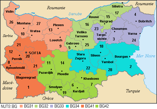
Varna Province ( bg, Област Варна, translit=Oblast Varna), formerly known as Varna okrug, is a province in eastern Bulgaria, one of the 28 Bulgarian provinces. It comprises 12 municipalities with a population of 494,216 inhabitants as of April 2016.http://www.grao.bg/tna/tab01.html“ The province is named after its administrative centre, Varna. Geography The province's territory is 3,819.5 km². It borders the Black Sea and covers parts of the hilly Danubian Plain (including parts of the Franga Plateau, South Dobruja, the Provadiya Plateau, Ludogorie, and the Avren Plateau), Eastern Stara Planina, the Varna– Devnya valley with the lakes ( limans) of Varna and Beloslav, and the Kamchiya river valley. Other rivers include Provadiya, Devnya, and Batova, and the largest artificial lake is Tsonevo. The Black Sea coast is hilly and verdant, mostly cliff, with a couple of rocky headlands (Cape Galata, Cape St. Athanasius), several expansive sand be ... [...More Info...] [...Related Items...] OR: [Wikipedia] [Google] [Baidu] |
Provinces Of Bulgaria
The provinces of Bulgaria ( bg, области на България, oblasti na Bǎlgarija) are the first-level administrative subdivisions of the country. Since 1999, Bulgaria has been divided into 28 provinces ( bg, области, links=no – ''oblasti;'' singular: – '' oblast''; also translated as "regions") which correspond approximately to the 28 districts (in bg, links=no, окръг – '' okrǎg'', plural: – ''okrǎzi''), that existed before 1987. The provinces are further subdivided into 265 municipalities (singular: – '' obshtina'', plural: – ''obshtini''). Sofia – the capital city of Bulgaria and the largest settlement in the country – is the administrative centre of both Sofia Province and Sofia City Province (Sofia- grad). The capital is included (together with three other cities plus 34 villages) in Sofia Capital Municipality (over 90% of whose population lives in Sofia), which is the sole municipality comprising Sofia City province. Term ... [...More Info...] [...Related Items...] OR: [Wikipedia] [Google] [Baidu] |
Lake Varna
Lake Varna ( bg, Варненско езеро, ) is the largest by volume and deepest liman or lake along the Bulgarian Black Sea Coast, divided from the sea by a 2 km-wide strip of sand and having an area of 19 km², maximal depth 19 m, and a volume of 166 million m³. The lake has an elongated shape, its south shores are high, steep and wooded, and the north slant. Lake Varna was formed in a river valley by the raising of sea level near the end of the Pleistocene. Its bottom is covered by a thick alluvium of slime and hydrogen sulphide mud in the deepest parts; there are large deposits of medicinal ''fango'' (mineral mud). A number of rivers pour into the lake, including Devnya and Provadiyska that empty near the western shores of Lake Beloslav, which is connected to Lake Varna. Until the 20th century, fresh water from the lake emptied into the Black Sea through the Devnya River, but following the construction of the modern Port of Varna East (and the subsequent dra ... [...More Info...] [...Related Items...] OR: [Wikipedia] [Google] [Baidu] |
Silica
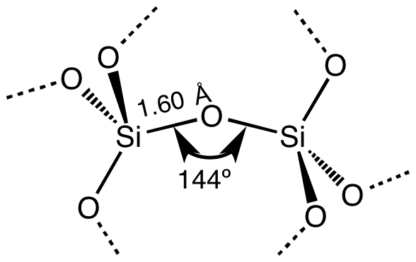
Silicon dioxide, also known as silica, is an oxide of silicon with the chemical formula , most commonly found in nature as quartz and in various living organisms. In many parts of the world, silica is the major constituent of sand. Silica is one of the most complex and most abundant families of materials, existing as a compound of several minerals and as a synthetic product. Notable examples include fused quartz, fumed silica, silica gel, opal and aerogels. It is used in structural materials, microelectronics (as an electrical insulator), and as components in the food and pharmaceutical industries. Structure In the majority of silicates, the silicon atom shows tetrahedral coordination, with four oxygen atoms surrounding a central Si atomsee 3-D Unit Cell. Thus, SiO2 forms 3-dimensional network solids in which each silicon atom is covalently bonded in a tetrahedral manner to 4 oxygen atoms. In contrast, CO2 is a linear molecule. The starkly different structures of th ... [...More Info...] [...Related Items...] OR: [Wikipedia] [Google] [Baidu] |
Limestone
Limestone ( calcium carbonate ) is a type of carbonate sedimentary rock which is the main source of the material lime. It is composed mostly of the minerals calcite and aragonite, which are different crystal forms of . Limestone forms when these minerals precipitate out of water containing dissolved calcium. This can take place through both biological and nonbiological processes, though biological processes, such as the accumulation of corals and shells in the sea, have likely been more important for the last 540 million years. Limestone often contains fossils which provide scientists with information on ancient environments and on the evolution of life. About 20% to 25% of sedimentary rock is carbonate rock, and most of this is limestone. The remaining carbonate rock is mostly dolomite, a closely related rock, which contains a high percentage of the mineral dolomite, . ''Magnesian limestone'' is an obsolete and poorly-defined term used variously for dolomite, for lime ... [...More Info...] [...Related Items...] OR: [Wikipedia] [Google] [Baidu] |
Rock Salt
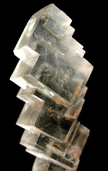
Halite (), commonly known as rock salt, is a type of salt, the mineral (natural) form of sodium chloride ( Na Cl). Halite forms isometric crystals. The mineral is typically colorless or white, but may also be light blue, dark blue, purple, pink, red, orange, yellow or gray depending on inclusion of other materials, impurities, and structural or isotopic abnormalities in the crystals. It commonly occurs with other evaporite deposit minerals such as several of the sulfates, halides, and borates. The name ''halite'' is derived from the Ancient Greek word for "salt", ἅλς (''háls''). Occurrence Halite dominantly occurs within sedimentary rocks where it has formed from the evaporation of seawater or salty lake water. Vast beds of sedimentary evaporite minerals, including halite, can result from the drying up of enclosed lakes and restricted seas. Such salt beds may be hundreds of meters thick and underlie broad areas. Halite occurs at the surface today in playas in regi ... [...More Info...] [...Related Items...] OR: [Wikipedia] [Google] [Baidu] |
Chernozem
Chernozem (from rus, чернозём, p=tɕɪrnɐˈzʲɵm, r=chernozyom; "black ground"), also called black soil, is a black-colored soil containing a high percentage of humus (4% to 16%) and high percentages of phosphorus and ammonia compounds. Chernozem is very fertile soil and can produce high agricultural yields with its high moisture storage capacity. Chernozems are a Reference Soil Group of the World Reference Base for Soil Resources (WRB). Distribution The name comes from the Russian terms for black and soil, earth or land (''chorny'' + ''zemlya''). The soil, rich in organic matter presenting a black color, was first identified by Russian geologist Vasily Dokuchaev in 1883 in the tallgrass steppe or prairie of European Russia. Chernozem cover about 230 million hectares of land. There are two "chernozem belts" in the world. One is the Eurasian steppe which extends from eastern Croatia ( Slavonia), along the Danube (northern Serbia, northern Bulgaria ( Danub ... [...More Info...] [...Related Items...] OR: [Wikipedia] [Google] [Baidu] |
Athanasius Of Alexandria
Athanasius I of Alexandria, ; cop, ⲡⲓⲁⲅⲓⲟⲥ ⲁⲑⲁⲛⲁⲥⲓⲟⲩ ⲡⲓⲁⲡⲟⲥⲧⲟⲗⲓⲕⲟⲥ or Ⲡⲁⲡⲁ ⲁⲑⲁⲛⲁⲥⲓⲟⲩ ⲁ̅; (c. 296–298 – 2 May 373), also called Athanasius the Great, Athanasius the Confessor, or, among Coptic Christians, Athanasius the Apostolic, was a Coptic church father and the 20th pope of Alexandria (as Athanasius I). His intermittent episcopacy spanned 45 years (c. 8 June 328 – 2 May 373), of which over 17 encompassed five exiles, when he was replaced on the order of four different Roman emperors. Athanasius was a Christian theologian, a Church Father, the chief defender of Trinitarianism against Arianism, and a noted Egyptian Christian leader of the fourth century. Conflict with Arius and Arianism, as well as with successive Roman emperors, shaped Athanasius' career. In 325, at age 27, Athanasius began his leading role against the Arians as a deacon and assistant to Bishop Alexander ... [...More Info...] [...Related Items...] OR: [Wikipedia] [Google] [Baidu] |
Headlands
A headland, also known as a head, is a coastal landform, a point of land usually high and often with a sheer drop, that extends into a body of water. It is a type of promontory. A headland of considerable size often is called a cape.Whittow, John (1984). ''Dictionary of Physical Geography''. London: Penguin, 1984, pp. 80, 246. . Headlands are characterised by high, breaking waves, rocky shores, intense erosion, and steep sea cliff. Headlands and bays are often found on the same coastline. A bay is flanked by land on three sides, whereas a headland is flanked by water on three sides. Headlands and bays form on discordant coastlines, where bands of rock of alternating resistance run perpendicular to the coast. Bays form when weak (less resistant) rocks (such as sands and clays) are eroded, leaving bands of stronger (more resistant) rocks (such as chalk, limestone, and granite) forming a headland, or peninsula. Through the deposition of sediment within the bay and the erosion of th ... [...More Info...] [...Related Items...] OR: [Wikipedia] [Google] [Baidu] |
Bulgarian Black Sea Coast
The Bulgarian Black Sea Coast (), also known as the Bulgarian Riviera, covers the entire eastern bound of Bulgaria stretching from the Romanian Black Sea resorts in the north to European Turkey in the south, along 378 km of coastline. White and golden sandy beaches occupy approximately 130 km of the 378 km long coast. The region is an important center of tourism during the summer season (May–October), drawing millions of foreign and local tourists alike and constituting one of the country's most popular tourist destinations. Prior to 1989 the Bulgarian Black Sea coast was internationally known as the ''Red Riviera''. Since the fall of the Iron Curtain, however, its nickname has been changed to the ''Bulgarian Riviera''. The Bulgarian Black Sea Coast has a humid subtropical climate (Köppen climate classification The Köppen climate classification is one of the most widely used climate classification systems. It was first published by German- ... [...More Info...] [...Related Items...] OR: [Wikipedia] [Google] [Baidu] |
Tsonevo (dam)
Tsonevo Reservoir is a reservoir located in the valley of the Luda Kamchia River, 1 km from the village of Tsonevo Tsonevo (Цонево) is a village located in the Luda Kamchiya Valley in Dalgopol Municipality, Varna Province, Bulgaria Bulgaria (; bg, България, Bǎlgariya), officially the Republic of Bulgaria,, ) is a country in Southeast .... The reservoir ranks third in size in Bulgaria with water service of 17300 decameters. Its old name was ''Georgi Traikov''. It has warm waters, and is used for water supply and irrigation. The reservoir is rich in fish such as bream, perch, rudd, and catfish. There are opportunities for fishing. The picturesque bed of the reservoir and the forested hills around it attract many tourists and offer great recreation possibilities. At Tsonevo reservoir there are bungalows, and private lodgings are offered in the adjacent villages of Tsonevo and Asparuhovo. At the latter, an ethnographical complex, Ovchaga, opene ... [...More Info...] [...Related Items...] OR: [Wikipedia] [Google] [Baidu] |
Batova
The Batova ( bg, Батова) is a river in northeastern Bulgaria. The river flows in a wide valley between the Dobruja plateau to the north and the Franga plateau to the south, ultimately flowing directly into the Black Sea. The Batova is only 39 kilometres long, but it is notable as the only river in Southern Dobruja that does not run dry on an annual basis. The river is deep between November and May, with a peak in February, and shallow during the remaining five months, particularly in July and August. The Batova's drainage basin covers 339 square kilometres and its average flow is 340 litres per second. The river passes through the village of Batovo in Dobrichka Dobrichka municipality ( bg, Община Добричка) or Dobrich rural municipality (Добрич-селска) is a municipality in Dobrich Province, Northeastern Bulgaria, located in Southern Dobruja geographical region. It lies in the cen ... municipality, Dobrich Province, after which it is named. Accordin ... [...More Info...] [...Related Items...] OR: [Wikipedia] [Google] [Baidu] |


.jpg)