|
Upchurch
Upchurch is a village and civil parish in the Swale district of Kent, England. It is situated just off the A2 road, between Rainham and Sittingbourne. History Upchurch lay on a pre-Roman trackway; the many linking roads are the result of Roman occupation, which had built a community of ex-soldiers who wanted to settle in England. A Roman cemetery has been discovered here. There were also several Roman pottery works sited here. It is probable that, although today the land is low-lying and marshy, it was once higher than it is today. The Upchurch Hoard is a hoard of well worn coins which date from the first and second century A.D. which were found close to Upchurch in 1950. Upchurch Hoard Andrew McCabe, ancients.info, accessed June 2010 A more recent pottery was established here in 1909 called the [...More Info...] [...Related Items...] OR: [Wikipedia] [Google] [Baidu] |
Upchurch Hoard
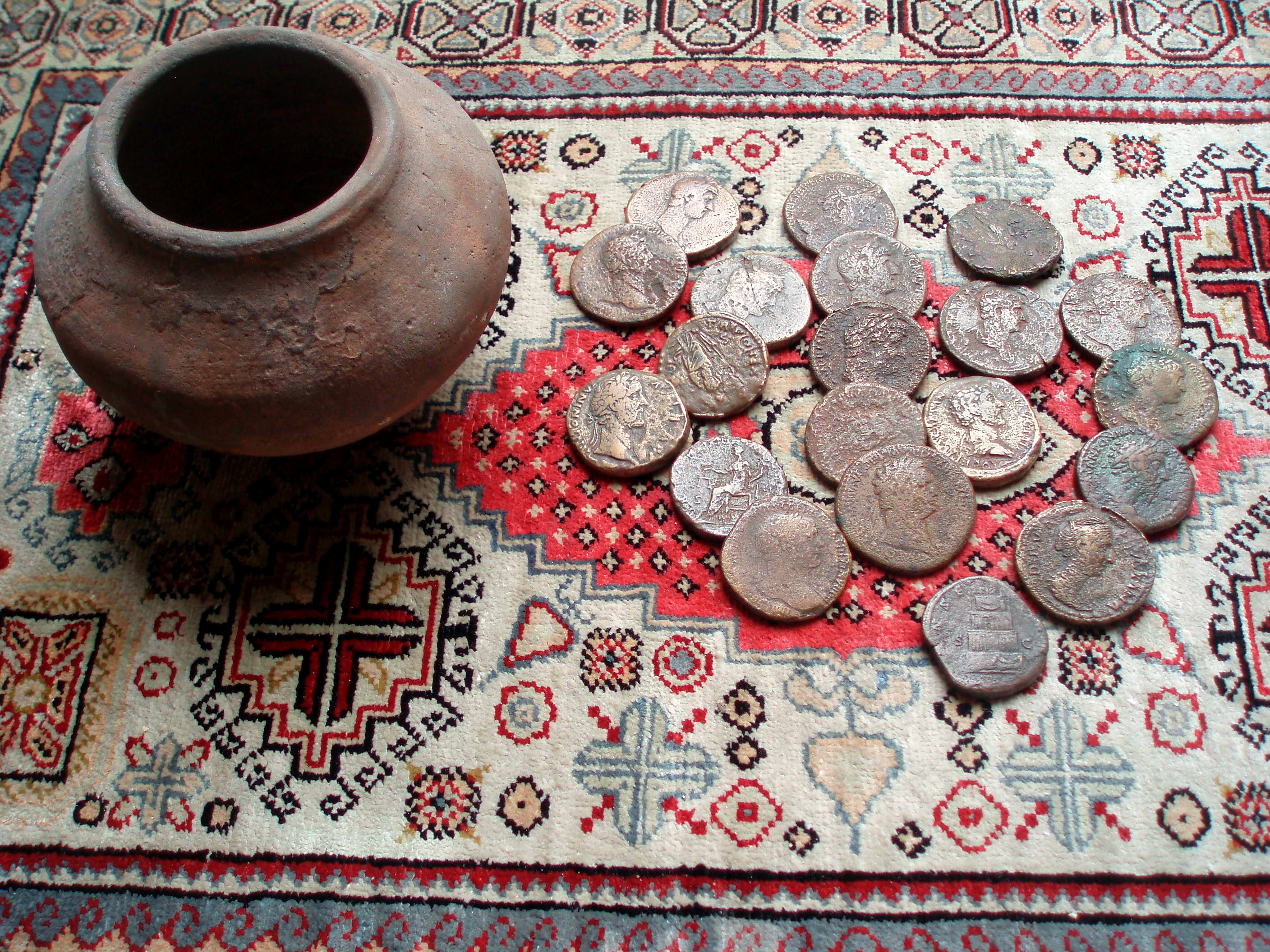
The Upchurch Hoard was a pot containing thirty-seven Roman sestertii dating from the late 1st century to the second half of the 2nd century AD found near the village of Upchurch, Kent, England, in 1950. Detail The Upchurch Hoard is a hoard of well worn coins that were found close to Upchurch in Kent, England. In the winter of 1950 a pot containing thirty-seven Roman ''sestertii'' dating from the late 1st century to the second half of the 2nd century AD was found in the area known as Slay Hill Saltings or Marshes north-west of Upchurch. All the coins were fairly worn, indicating a long period of use, with the most recent Divus Aurelius and Faustina II in ''Very Fine'' condition, and those of Domitian and Trajan in ''Fine'' condition although some had corrosion and others with good surfaces. Judging from this, and the pot, which is a small bellied Olla, a type typical for the area, the hoard was probably concealed sometime in the early 3rd century. Seventeen of the original thirt ... [...More Info...] [...Related Items...] OR: [Wikipedia] [Google] [Baidu] |
Upchurch Pottery
Upchurch Pottery was a pottery business established in 1909 in Upchurch, Kent, by the Wakely brothers. Most of the clay used in production was taken from what is now called Springbank Farm in Poot Lane Upchurch. In the mid-1930s it was bought by Alice Buxton Winnicott and here she manufactured her Claverdon tableware.Clifford Yorke, ‘Winnicott, Donald Woods (1896–1971)’, Oxford Dictionary of National Biography, Oxford University Press, 2004; online edn, Sept 201accessed 20 Feb 2017/ref> named after her birthplace and sold in Heals, on the Tottenham Court Road, London.Greer, J (2014) Learning from Linked Lives, unpublished thesis, University of Southampton , mottoeng = The Heights Yield to Endeavour , type = Public research university , established = 1862 – Hartley Institution1902 – Hartley University College1913 – Southampton University Coll ... References External linksPottery Studio - Upchurch Pottery [...More Info...] [...Related Items...] OR: [Wikipedia] [Google] [Baidu] |
Sittingbourne And Sheppey (UK Parliament Constituency)
Sittingbourne and Sheppey is a constituency in Kent represented in the House of Commons of the UK Parliament since 2010 by Gordon Henderson, a Conservative. Boundaries 1997–2010: The Borough of Swale wards of Borden, Eastern, Grove, Hartlip and Upchurch, Iwade and Lower Halstow, Kemsley, Milton Regis, Minster Cliffs, Murston, Newington, Queenborough and Halfway, Roman, Sheerness East, Sheerness West, Sheppey Central, West Downs, Woodstock. 2010–2015: The Borough of Swale wards of Borden, Chalkwell, Grove, Hartlip, Newington and Upchurch, Iwade and Lower Halstow, Kemsley, Leysdown and Warden, Milton Regis, Minster Cliffs, Murston, Queenborough and Halfway, Roman, St Michael's, Sheerness East, Sheerness West, Sheppey Central, Teynham and Lynsted, West Downs, Woodstock. 2015–present: The Borough of Swale wards of Bobbing, Iwade and Lower Halstow, Borden and Grove Park, Chalkwell, Hartlip, Newington and Upchurch, Homewood, Kemsley, Milton Regis, Minster Cliffs, Murston, Queenb ... [...More Info...] [...Related Items...] OR: [Wikipedia] [Google] [Baidu] |
Borough Of Swale
Swale is a local government district with borough status in Kent, England and is bounded by Medway to the west, Canterbury to the east, Ashford to the south and Maidstone to the south west. Its council is based in Sittingbourne. The district is named after the narrow channel called The Swale, that separates the mainland of Kent from the Isle of Sheppey, and which occupies the central part of the district. The district was formed in 1974 under the Local Government Act 1972, from the Borough of Faversham; the Borough of Queenborough-in-Sheppey, which covered the whole of Sheppey; the Sittingbourne and Milton Urban District; and Swale Rural District. Most of the southern half of the Borough lies within the Kent Downs Area of Outstanding Natural Beauty, whilst Sittingbourne and the Isle of Sheppey forms the concluding part of the Thames Gateway growth area. There are four towns in the borough: Sittingbourne and Faversham on the mainland, and Sheerness and Queenborough on S ... [...More Info...] [...Related Items...] OR: [Wikipedia] [Google] [Baidu] |
Villages In Kent ...
__NOTOC__ See also *List of settlements in Kent by population * List of civil parishes in Kent * :Civil parishes in Kent * :Towns in Kent * :Villages in Kent * :Geography of Kent *List of places in England {{Kent Places Kent Kent is a county in South East England and one of the home counties. It borders Greater London to the north-west, Surrey to the west and East Sussex to the south-west, and Essex to the north across the estuary of the River Thames; it faces ... [...More Info...] [...Related Items...] OR: [Wikipedia] [Google] [Baidu] |
Civil Parishes In England
In England, a civil parish is a type of Parish (administrative division), administrative parish used for Local government in England, local government. It is a territorial designation which is the lowest tier of local government below districts of England, districts and metropolitan and non-metropolitan counties of England, counties, or their combined form, the Unitary authorities of England, unitary authority. Civil parishes can trace their origin to the ancient system of Parish (Church of England), ecclesiastical parishes, which historically played a role in both secular and religious administration. Civil and religious parishes were formally differentiated in the 19th century and are now entirely separate. Civil parishes in their modern form came into being through the Local Government Act 1894, which established elected Parish councils in England, parish councils to take on the secular functions of the vestry, parish vestry. A civil parish can range in size from a sparsely ... [...More Info...] [...Related Items...] OR: [Wikipedia] [Google] [Baidu] |
A2 Road (Great Britain)
The A2 is a major road in south-east England, connecting London with the English Channel port of Dover in Kent. This route has always been of importance as a connection between London and sea trade routes to Continental Europe. It was originally known as the Dover Road. The M2 motorway has replaced part of the A2 as the strategic route. Unlike the other single digit A-roads in Great Britain, the A2 does not form a zone boundary. The boundary between Zones 1 and 2 is the River Thames. History of the route The route of the current A2 follows a similar route to that of a Celtic ancient trackway. It was an important route for the Romans linking London with Canterbury and the three Channel ports of Rutupiae (now Richborough), Dubris (now Dover) and Portus Lemanis (in modern Lympne). It had river crossings at Rochester over the River Medway; Dartford (River Darent) and Crayford (River Cray). The Romans paved the road and constructed the first Rochester Bridge across the Medway. ... [...More Info...] [...Related Items...] OR: [Wikipedia] [Google] [Baidu] |
Rainham, Kent
Rainham ( ) is a town in the unitary authority of Medway, in Kent, South East England. The town forms a conurbation with neighbouring towns Chatham, Rochester, Strood and Gillingham. Historically, Rainham was a separate village until, in 1928, it was added to the Municipal Borough of Gillingham, which was originally created in 1903 and was grouped into the latter's built-up area in analysis of the 2011 census by the Office for National Statistics. It became part of the Medway authority when Gillingham was incorporated with the other towns to form Medway Unitary Authority in 1998. Geography Rainham occupies a large stretch of land from the dip slope of a moderate rise of the North Downs of about above sea level, descending to a frontage on the River Medway's natural harbour to the north. London is approximately to the west. Three roads cross the town. The M2 motorway runs along its southern edge, from the town centre. The main road through the town, the A2, follows the an ... [...More Info...] [...Related Items...] OR: [Wikipedia] [Google] [Baidu] |
Ancient Rome
In modern historiography, ancient Rome refers to Roman civilisation from the founding of the city of Rome in the 8th century BC to the collapse of the Western Roman Empire in the 5th century AD. It encompasses the Roman Kingdom (753–509 BC), Roman Republic (509–27 BC) and Roman Empire (27 BC–476 AD) until the fall of the western empire. Ancient Rome began as an Italic settlement, traditionally dated to 753 BC, beside the River Tiber in the Italian Peninsula. The settlement grew into the city and polity of Rome, and came to control its neighbours through a combination of treaties and military strength. It eventually dominated the Italian Peninsula, assimilated the Greek culture of southern Italy ( Magna Grecia) and the Etruscan culture and acquired an Empire that took in much of Europe and the lands and peoples surrounding the Mediterranean Sea. It was among the largest empires in the ancient world, with an estimated 50 to 90 million inhabitants, roughly 20% of t ... [...More Info...] [...Related Items...] OR: [Wikipedia] [Google] [Baidu] |
Kent
Kent is a county in South East England and one of the home counties. It borders Greater London to the north-west, Surrey to the west and East Sussex to the south-west, and Essex to the north across the estuary of the River Thames; it faces the French department of Pas-de-Calais across the Strait of Dover. The county town is Maidstone. It is the fifth most populous county in England, the most populous non-Metropolitan county and the most populous of the home counties. Kent was one of the first British territories to be settled by Germanic tribes, most notably the Jutes, following the withdrawal of the Romans. Canterbury Cathedral in Kent, the oldest cathedral in England, has been the seat of the Archbishops of Canterbury since the conversion of England to Christianity that began in the 6th century with Saint Augustine. Rochester Cathedral in Medway is England's second-oldest cathedral. Located between London and the Strait of Dover, which separates England from mainla ... [...More Info...] [...Related Items...] OR: [Wikipedia] [Google] [Baidu] |
Sittingbourne
Sittingbourne is an industrial town in Kent, south-east England, from Canterbury and from London, beside the Roman Watling Street, an ancient British trackway used by the Romans and the Anglo-Saxons and next to the Swale, a strip of sea separating mainland Kent from the Isle of Sheppey. The town became prominent after the death of Thomas Becket in 1170, since it provided a convenient resting point on the road from London to Canterbury and Dover. Chatham Main Line links to London Victoria and HS1 to St Pancras International, the journey taking about an hour from Sittingbourne railway station. History Sittingbourne owes its name to a modernised version of an observation on its location. The town's name came from the fact that there is a small stream or "bourne" running underground in part of the town. Hasted writing in the 1790s in his ''History of Kent'' states that: The Kent Hundred Rolls of 1274–5, preserved in the National Archives, record Sittingbourne as Sydingeburn ... [...More Info...] [...Related Items...] OR: [Wikipedia] [Google] [Baidu] |
Liberty (department Store)
Liberty, commonly known as Liberty's, is a luxury department store in London, England. It is located on Great Marlborough Street in the West End of London. The building spans from Carnaby Street on the East to Kingly Street on the West, where it forms a three storey archway over the Northern entrance to the Kingly Street mall that houses the Liberty Clock in its centre. Liberty is known around the world for its close connection to art and culture, it is most famous for its bold and floral print fabrics. The vast mock-Tudor store also sells men's, women's and children's fashion, beauty and homewares from a mix of high-end and emerging brands and labels. The store is known to spot and champion young designers at the start of their careers, and many now-prominent brands were first available at Liberty. The store played essential role in spreading and popularizing the Modern Style. This continues Liberty's long reputation for working with British artists and designers. History Ea ... [...More Info...] [...Related Items...] OR: [Wikipedia] [Google] [Baidu] |


_London_UK.jpg)