|
Ufa Station
Ufa is a Central Ufa railway terminus, located in the Sovetsky District of Ufa on the historical direction of the Trans-Siberian Railway. In managerial terms, the station enters the Bashkir region of the Kuybyshev Railway. History The history of Ufa Station is associated with the construction of the Samara-Ufa railway. Construction on the Samara-Ufa railway began in 1885, and in 1888 it was brought to the city of Ufa. In 1888 the station began to function as the railway's final destination. In 1890, the Ufa-Zlatoust section was built. In 1892, the Zlatoust-Chelyabinsk section was built. From the opening of traffic on the Siberian railway and on the Yekaterinburg - Chelyabinsk branch (1896) to the opening of the Petersburg-Vologda-Vyatka railway (1906), the station was located on the only rail track connecting Russia and Europe with the Urals, Siberia and the Far East. [...More Info...] [...Related Items...] OR: [Wikipedia] [Google] [Baidu] |
Kuybyshev Railway
The Kuybyshevskaya Railway (Ку́йбышевская желе́зная доро́га) is a subsidiary of the Russian Railways operating in Tatarstan, Bashkortostan, Mordovia, Ryazan Oblast, Penza, Tambov, Ulyanovsk, Samara, Orenburg, and Chelyabinsk Oblasts of Russia. Its headquarters are in Samara. The railway route length totals 11 502 km. The oldest railway in the network is that linking Morshansk and Syzran; it was built between 1872 and 1875. In 1880, engineers Nikolai Belelubsky and Konstantin Mikhailovsky designed the Syzran Bridge across the Volga, then the longest in Europe. The railway reached Zlatoust in 1890 and Chelyabinsk two years later. The main office of the Samara–Zlatoust Railway was located in Ufa. After the Russian Revolution The Russian Revolution was a period of Political revolution (Trotskyism), political and social revolution that took place in the former Russian Empire which began during the First World War. This period saw ... [...More Info...] [...Related Items...] OR: [Wikipedia] [Google] [Baidu] |
Bashkortostan
The Republic of Bashkortostan or Bashkortostan ( ba, Башҡортостан Республикаһы, Bashqortostan Respublikahy; russian: Республика Башкортостан, Respublika Bashkortostan),; russian: Респу́блика Башкортоста́н, r=Respublika Bashkortostan, p=rʲɪsˈpublʲɪkə bəʂkərtɐˈstan also unofficially called Bashkiria (russian: Башкирия, tr. Bashkiriya), is a republic of Russia located between the Volga and the Ural Mountains in Eastern Europe. It covers and has a population of 4 million. It is Russia's 7th most populous federal subject and most populous republic. Its capital and largest city is Ufa. Bashkortostan was established on .Национально-государственное устройство Башкортостана, 1917–1925 гг: Общее введение и Том 1 // Билал Хамитович Юлдашбаев, Китап, 2002, , 9785295029165Хрестоматия по и� ... [...More Info...] [...Related Items...] OR: [Wikipedia] [Google] [Baidu] |
Russia
Russia (, , ), or the Russian Federation, is a List of transcontinental countries, transcontinental country spanning Eastern Europe and North Asia, Northern Asia. It is the List of countries and dependencies by area, largest country in the world, with its internationally recognised territory covering , and encompassing one-eighth of Earth's inhabitable landmass. Russia extends across Time in Russia, eleven time zones and shares Borders of Russia, land boundaries with fourteen countries, more than List of countries and territories by land borders, any other country but China. It is the List of countries and dependencies by population, world's ninth-most populous country and List of European countries by population, Europe's most populous country, with a population of 146 million people. The country's capital and List of cities and towns in Russia by population, largest city is Moscow, the List of European cities by population within city limits, largest city entirely within E ... [...More Info...] [...Related Items...] OR: [Wikipedia] [Google] [Baidu] |
Transport Hub
A transport hub is a place where passengers and cargo are exchanged between vehicles and/or between transport modes. Public transport hubs include railway stations, rapid transit stations, bus stops, tram stops, airports and ferry slips. Freight hubs include classification yards, airports, seaports and truck terminals, or combinations of these. For private transport by car, the parking lot functions as a unimodal hub. History Historically, an interchange service in the scheduled passenger air transport industry involved a "through plane" flight operated by two or more airlines where a single aircraft was used with the individual airlines operating it with their own flight crews on their respective portions of a direct, no-change-of-plane multi-stop flight. In the U.S., a number of air carriers including Alaska Airlines, American Airlines, Braniff International Airways, Continental Airlines, Delta Air Lines, Eastern Airlines, Frontier Airlines (1950-1986), Hughes Airwest, ... [...More Info...] [...Related Items...] OR: [Wikipedia] [Google] [Baidu] |
Trans-Siberian Railway
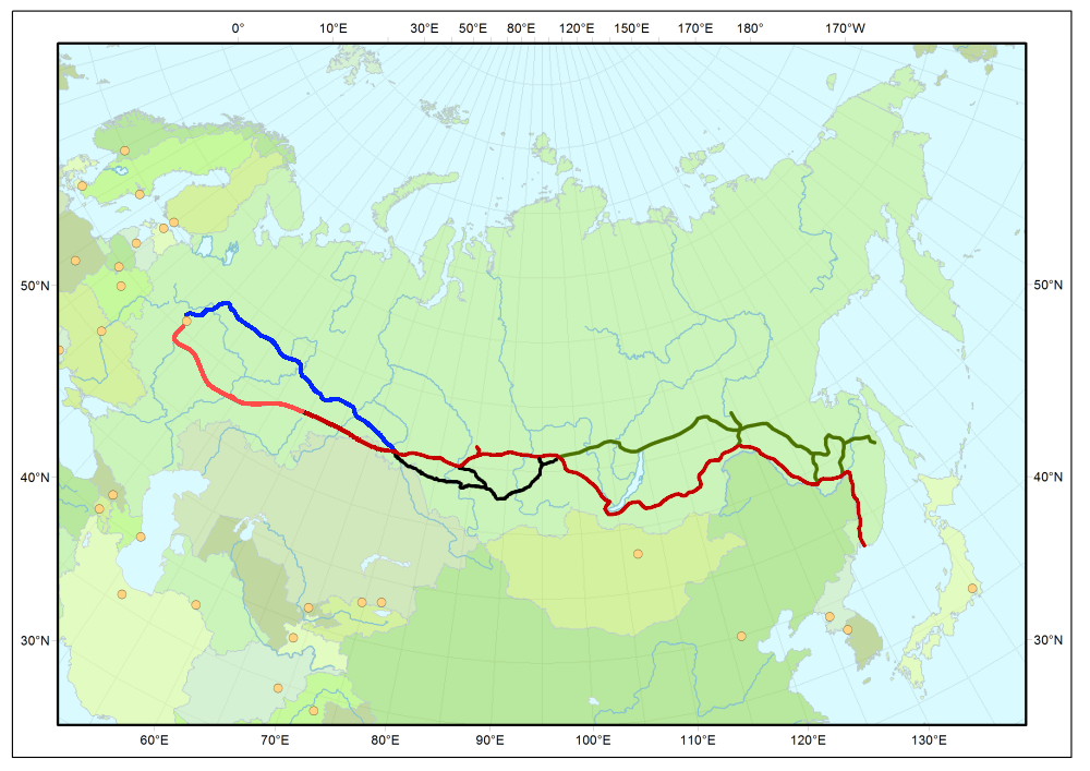
The Trans-Siberian Railway (TSR; , , ) connects European Russia to the Russian Far East. Spanning a length of over , it is the longest railway line in the world. It runs from the city of Moscow in the west to the city of Vladivostok in the east. During the period of the Russian Empire, government ministers—personally appointed by Alexander III and his son Nicholas II—supervised the building of the railway network between 1891 and 1916. Even before its completion, the line attracted travelers who documented their experiences. Since 1916, the Trans-Siberian Railway has directly connected Moscow with Vladivostok. , expansion projects remain underway, with connections being built to Russia's neighbors (namely Mongolia, China, and North Korea). Additionally, there have been proposals and talks to expand the network to Tokyo, Japan, with new bridges that would connect the mainland railway through the Russian island of Sakhalin and the Japanese island of Hokkaido. Route descrip ... [...More Info...] [...Related Items...] OR: [Wikipedia] [Google] [Baidu] |
Map Trans-Siberian Railway
A map is a symbolic depiction emphasizing relationships between elements of some space, such as Physical body, objects, regions, or themes. Many maps are static, fixed to paper or some other durable medium, while others are dynamic or interactive. Although most commonly used to depict geography, maps may represent any space, real or fictional, without regard to Context (language use), context or Scale (map), scale, such as in brain mapping, DNA mapping, or computer network topology mapping. The space being mapped may be two dimensional, such as the surface of the earth, three dimensional, such as the interior of the earth, or even more abstract spaces of any dimension, such as arise in modeling phenomena having many independent variables. Although the earliest maps known are of the heavens, geographic maps of territory have a very long tradition and exist from ancient times. The word "map" comes from the , wherein ''mappa'' meant 'napkin' or 'cloth' and ''mundi'' 'the world'. ... [...More Info...] [...Related Items...] OR: [Wikipedia] [Google] [Baidu] |
Ufa International Airport
Ufa International Airport (russian: Международный аэропорт Уфа, ''Mezhdunarodnyy aeroport Ufa'', ba, Өфө халыҡ-ара аэропорты, ) is the primary airport serving Ufa, the capital of Bashkortostan, Russia. In 2017, the airport handled 2,810,000 passengers, becoming the tenth largest airport in Russia and the largest airport in Russia's Volga Federal District. It is also the largest airport in the federal subject (republic) of the Republic of Bashkortostan. Former BAL Bashkirian Airlines used to be headquartered at the airport. History On 11 May 1924, the building of the first aircraft hangar near Glumilino village was completed. On 15 May, is opened a new aviation club within the Bashkirian branch of AFFVS. In 1933, the first ever route opened, encompassing over 730 km via Ufa–Sterlitamak– Meleuz–Mrakovo–Baymak–Magnitogorsk–Beloretsk–Ufa. In 1956, Ufa Airport began performing technical maintenance of the Yakovlev ... [...More Info...] [...Related Items...] OR: [Wikipedia] [Google] [Baidu] |
Belorechensky Neighbourhood
Belorechensky (masculine), Belorechenskaya (feminine), or Belorechenskoye (neuter) may refer to: * Belorechensky District, a district of Krasnodar Krai, Russia * Belorechenskoye Urban Settlement, several municipal urban settlements in Russia * Belorechensky, Russia (''Belorechenskaya'', ''Belorechenskoye''), several inhabited localities in Russia * Bilorichenskyi (''Belorechensky''), an urban-type settlement in Luhansk Oblast, Ukraine *Belorechenskaya railway station, a railway station on the North Caucasus Railway, Russia * Belorechenskaya Hydroelectric Station, a power station in Russia * Bilorichenska coal mine (''Belorechenskaya coal mine''), a coal mine in Ukraine {{Disambiguation, geo ... [...More Info...] [...Related Items...] OR: [Wikipedia] [Google] [Baidu] |
Inors Neighbourhood
Inors( ba, Инорс, russian: Ино́рс) is a neighbourhood of Ufa, Bashkortostan. It is bordered by the Ufa River on the south and the Ufa engine-building production association teritiory on the north and Sipailovo on the west conditional. It is a residential area, containing the park, the Ufa engine-building production association, the Rezyapov Ufa number 2 thermal power station. The population of the district is approximately 70000 people. Inors is also a former the Bogorodskoe village. Gallery File:If You Love Your Work There Are No Barriers Even (188448147).jpeg, View of Ufa River along Inors neighborhood File:Su-27 UMPO (Ufa).jpg, Model of Sukhoi Su-27 The Sukhoi Su-27 (russian: Сухой Су-27; NATO reporting name: Flanker) is a Soviet-origin twin-engine supermaneuverable fighter aircraft designed by Sukhoi. It was intended as a direct competitor for the large US fourth-generation jet ... in front of Ufa engine-building production association File:La ... [...More Info...] [...Related Items...] OR: [Wikipedia] [Google] [Baidu] |
Zaton Neighbourhood
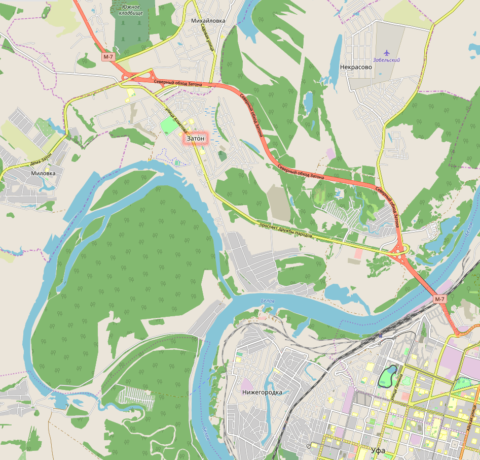
Zaton neighbourhood is a neighbourhood of the city of Ufa, capital of the Republic of Bashkortostan, Russia. It is bordered by the Belaya River on the east and Volga Highway on the north and Milovka village on the south conditional. It is a residential area, containing the park, the Zaton TEC-combined heat and power plant, ship-repair plant. The population of the district is approximately 50000 people. Inors is also a former the Kirzhackij or Starickij Zaton village. Zaton neighbourhood is connected by Zaton bridge with the rest of Ufa. Zaton neighbourhood will have been connected by Ufa Eastern Toll Road Eastern Exit ( ba, Көнсығыш сығыу юлы, russian: Восточный выезд) is a road-construction project in Ufa, Bashkortostan, a toll transport corridor connecting the Ufa city centre to the M-5 federal highway. It is Bashko ... with the Ural highway, and by that fact with all Ural. Gallery File:Location of Ufa Zaton.svg, Location of Ufa Zaton File: ... [...More Info...] [...Related Items...] OR: [Wikipedia] [Google] [Baidu] |
Sipailovo Neighbourhood
Sipailovo( ba, Һупайлы, russian: Сипайлово) is a neighbourhood of Ufa, Bashkortostan. It is bordered by the Ufa River on the east and the south and the Glumilino neighbourhood on the north and the Inors neighbourhood on the northeast conditional. It is a residential area, containing the Kashkadan park. Sipailovo neighbourhood is also a former Sipailovo village. Gallery File:Ufa Sipailovo summer wide.jpg, Ufa, Sipailovo at summer Transport *No.110 Inors neighbourhood →Sipailovo neighbourhood→ Ufa International Airport *No.101 Ufa Railway Station→Sipailovo neighbourhood→Inors neighbourhood Inors( ba, Инорс, russian: Ино́рс) is a neighbourhood of Ufa, Bashkortostan. It is bordered by the Ufa River on the south and the Ufa engine-building production association teritiory on the north and Sipailovo on the west condition ... *No.230 Dzerzhinsky Street→ Kashkadan Park (Sipailovo neighbourhood) *No.251 Ufa Station→ Kashkadan Park (Sipa ... [...More Info...] [...Related Items...] OR: [Wikipedia] [Google] [Baidu] |
Transport In Ufa
Transport (in British English), or transportation (in American English), is the intentional movement of humans, animals, and goods from one location to another. Modes of transport include air, land ( rail and road), water, cable, pipeline, and space. The field can be divided into infrastructure, vehicles, and operations. Transport enables human trade, which is essential for the development of civilizations. Transport infrastructure consists of both fixed installations, including roads, railways, airways, waterways, canals, and pipelines, and terminals such as airports, railway stations, bus stations, warehouses, trucking terminals, refueling depots (including fueling docks and fuel stations), and seaports. Terminals may be used both for interchange of passengers and cargo and for maintenance. Means of transport are any of the different kinds of transport facilities used to carry people or cargo. They may include vehicles, riding animals, and pack an ... [...More Info...] [...Related Items...] OR: [Wikipedia] [Google] [Baidu] |


