|
USS Advance (1847)
The first USS ''Advance'' was a brigantine in the United States Navy which participated in an Arctic rescue expedition. ''Advance'' was built in 1847 as ''Augusta'' in New Kent County, Virginia and loaned to the Navy on 7 May 1850 by Henry Grinnell to participate in the search for Sir John Franklin's Arctic expedition which had been stranded in the frozen north since 1846. After last-minute preparations, the ship, under the command of Lieutenant Edwin J. De Haven and in company with , put to sea from New York on 23 May 1850. First rescue expedition Storms battered the two ships on the initial leg of the voyage and separated them. However, both safely reached Disko Island, located off the west coast of Greenland where Davis Strait gives way to Baffin Bay. ''Advance'' arrived on 24 June, and ''Rescue'' pulled into port three days later. On the 29th, the two ships headed into Baffin Bay, bound for Lancaster Sound located north of Baffin Island and south of Devon Island. Off H ... [...More Info...] [...Related Items...] OR: [Wikipedia] [Google] [Baidu] |
Brigantine
A brigantine is a two-masted sailing vessel with a fully square-rigged foremast and at least two sails on the main mast: a square topsail and a gaff sail mainsail (behind the mast). The main mast is the second and taller of the two masts. Older usages are looser; in addition to the rigorous definition above (attested from 1695), the ''Oxford English Dictionary'' has about 1525 definitions of "a small vessel equipped both for sailing and rowing, swifter and more easily manœuvred than larger ships" and "(loosely) various kinds of foreign sailing and rowing vessels, as the galleon, galliot, etc." Modern American definitions include vessels without the square sails on the main mast. Mediterranean brigantines In the Mediterranean Basin during the 13th century, a brigantine referred to a sail- and oar-driven war vessel. It was lateen rigged on two masts and had between eight and twelve oars on each side. Its speed, maneuverability, and ease of handling made it a favourite of Mediter ... [...More Info...] [...Related Items...] OR: [Wikipedia] [Google] [Baidu] |
Cape Spencer (Alaska)
Cape Spencer is a headland on the Alaska shore, at the side of the entrance to Cross Sound west of Juneau, Alaska. Located in Glacier Bay National Park and Preserve Glacier Bay National Park and Preserve is an American national park located in Southeast Alaska west of Juneau. President Calvin Coolidge proclaimed the area around Glacier Bay a national monument under the Antiquities Act on February 26, 1925. ..., it is the site of the Cape Spencer Light. Spencer Landforms of Hoonah–Angoon Census Area, Alaska {{HoonahAngoonAK-geo-stub ... [...More Info...] [...Related Items...] OR: [Wikipedia] [Google] [Baidu] |
Whaleboat
A whaleboat is a type of open boat that was used for catching whales, or a boat of similar design that retained the name when used for a different purpose. Some whaleboats were used from whaling ships. Other whaleboats would operate from the shore. Later whaleboats usually could operate under sail or oar - American whaling crews in particular obtained better results by making their first approach to a whale under sail, then quickly unstepping the mast and using oars thereafter. Most whaleboats have double-ended, clinker-built hulls of light construction. The hulls were narrow and with sharp ends to achieve the best possible speed for the length of waterline. Length was between 27 and 31 feet. Beam was just over a fifth of the length. Typically they were propelled by five oars when rowed, and stepped a single removable mast when under sail. A rudder was used when under sail and a steering oar when the boat was rowed. The latter provided the manoeuvrability needed when closing wi ... [...More Info...] [...Related Items...] OR: [Wikipedia] [Google] [Baidu] |
Denmark
) , song = ( en, "King Christian stood by the lofty mast") , song_type = National and royal anthem , image_map = EU-Denmark.svg , map_caption = , subdivision_type = Sovereign state , subdivision_name = Danish Realm, Kingdom of Denmark , established_title = History of Denmark#Middle ages, Consolidation , established_date = 8th century , established_title2 = Christianization , established_date2 = 965 , established_title3 = , established_date3 = 5 June 1849 , established_title4 = Faroese home rule , established_date4 = 24 March 1948 , established_title5 = European Economic Community, EEC 1973 enlargement of the European Communities, accession , established_date5 = 1 January 1973 , established_title6 = Greenlandic home rule , established_date6 = 1 May 1979 , official_languages = Danish language, Danish , languages_type = Regional languages , languages_sub = yes , languages = German language, GermanGerman is recognised as a protected minority language in t ... [...More Info...] [...Related Items...] OR: [Wikipedia] [Google] [Baidu] |
Scurvy
Scurvy is a disease resulting from a lack of vitamin C (ascorbic acid). Early symptoms of deficiency include weakness, feeling tired and sore arms and legs. Without treatment, decreased red blood cells, gum disease, changes to hair, and bleeding from the skin may occur. As scurvy worsens there can be poor wound healing, personality changes, and finally death from infection or bleeding. It takes at least a month of little to no vitamin C in the diet before symptoms occur. In modern times, scurvy occurs most commonly in people with mental disorders, unusual eating habits, alcoholism, and older people who live alone. Other risk factors include intestinal malabsorption and dialysis. While many animals produce their own vitamin C, humans and a few others do not. Vitamin C is required to make the building blocks for collagen. Diagnosis is typically based on physical signs, X-rays, and improvement after treatment. Treatment is with vitamin C supplements taken by mouth. Improvemen ... [...More Info...] [...Related Items...] OR: [Wikipedia] [Google] [Baidu] |
Ellesmere Island
Ellesmere Island ( iu, script=Latn, Umingmak Nuna, lit=land of muskoxen; french: île d'Ellesmere) is Canada's northernmost and List of Canadian islands by area, third largest island, and the List of islands by area, tenth largest in the world. It comprises an area of , slightly smaller than Great Britain, and the total length of the island is . Lying within the Arctic Archipelago, Ellesmere Island is considered part of the Queen Elizabeth Islands. Cape Columbia at 83°06′ is the northernmost point of land in Canada and one of the northernmost points of land on the planet (the northernmost point of land on Earth is the nearby Kaffeklubben Island of Greenland). The Arctic Cordillera mountain system covers much of Ellesmere Island, making it the most mountainous in the Arctic Archipelago. More than one-fifth of the island is protected as Quttinirpaaq National Park. In 2021, the population of Ellesmere Island was recorded at 144. There are three settlements: Alert, Nunavut, Aler ... [...More Info...] [...Related Items...] OR: [Wikipedia] [Google] [Baidu] |
Greenlandic Inuit
Greenlanders ( kl, Kalaallit / Tunumiit / Inughuit; da, Grønlændere) are people identified with Greenland or the indigenous people, the Greenlandic Inuit (''Grønlansk Inuit''; Kalaallit, Inughuit, and Tunumiit). This connection may be residential, legal, historical, or cultural. For most Greenlanders, many of these connections exist and are collectively the source of their being ''Greenlandic''. However, the term can in different contexts be delimited more precisely in different ways: as the inhabitants of Greenland, as nationals of Greenland or more broadly as persons who feel a cultural affiliation in a broad sense to Greenland. More controversial is a more recent use of the word in the sense persons of Greenlandic origin, i.e. persons whose parents were born in Greenland. The indigenous people of Greenland, or the Greenlandic Inuit, have ''indigenous status'' in the Kingdom of Denmark. Nationals of Greenland are citizens of Denmark and are overseas countries and ter ... [...More Info...] [...Related Items...] OR: [Wikipedia] [Google] [Baidu] |
Kane Basin
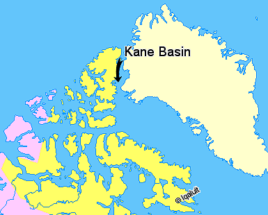
Kane Basin ( da, Kane Bassin; french: Bassin (de) Kane) is an Arctic waterway lying between Greenland and Canada's northernmost island, Ellesmere Island. It links Smith Sound to Kennedy Channel and forms part of Nares Strait. It is approximately 180 kilometres in length and 130 km at its widest. It is named after the American explorer Elisha Kane, whose expedition in search of Franklin's lost expedition crossed it in 1854. Kane himself had named it "Peabody Bay," in honor of philanthropist George Peabody, the major funder of Kane's expedition. Currently Peabody Bay is a bay at the eastern side of the basin, off the southwestern end of the Humboldt Glacier Humboldt Glacier ( da, Humboldt Gletscher) is one of the major glaciers in northern Greenland. The glacier is named after German naturalist Alexander von Humboldt and is the widest tidewater glacier in the Northern Hemisphere. Geography The Humb ... in northern Greenland. Further reading * Cold Regions Research and ... [...More Info...] [...Related Items...] OR: [Wikipedia] [Google] [Baidu] |
Smith Sound
Smith Sound ( da, Smith Sund; french: Détroit de Smith) is an uninhabited Arctic sea passage between Greenland and Canada's northernmost island, Ellesmere Island. It links Baffin Bay with Kane Basin and forms part of the Nares Strait. On the Greenland side of the sound were the now abandoned settlements of Etah and Annoatok. History The first known visit to the area by Europeans was in 1616 when the ''Discovery'', captained by Robert Bylot and piloted by William Baffin, sailed into this region. The sound was originally named ''Sir Thomas Smith's Bay'' after the English diplomat Sir Thomas Smythe. By the 1750s it regularly appeared on maps as ''Sir Thomas Smith's Sound'', though no further exploration of the area would be recorded until John Ross' 1818 expedition. By this time it had begun to be known simply as ''Smith Sound''. In 1852 Edward Augustus Inglefield penetrated a little further than Baffin, establishing a new furthest north in North America. References Further ... [...More Info...] [...Related Items...] OR: [Wikipedia] [Google] [Baidu] |
Upernavik
Upernavik (Kalaallisut: "Springtime Place") is a small town in the Avannaata municipality in northwestern Greenland, located on a small island of the same name. With 1,092 inhabitants as of 2020, it is the twelfth-largest town in Greenland. It contains the Upernavik Museum. History The town was founded as Upernavik in 1772. From the former name of its island, it was sometimes known as Women's Island; its name was also sometimes Anglicized to "Uppernavik".Walker, J. & al.British North America. Baldwin & Cradock (London), 1844. In 1824, the Kingittorsuaq Runestone was found outside the town. It bears runic characters left by Norsemen, probably from the late 13th century. The runic characters list the names of three Norsemen and mention the construction of a rock cairn nearby. This is the furthest north that any Norse artifacts have been found, other than those small artifacts that could have been carried north by Inuit traders, and marks the northern known limit of Viking exp ... [...More Info...] [...Related Items...] OR: [Wikipedia] [Google] [Baidu] |
Elisha Kane
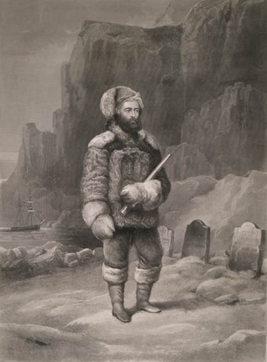
Elisha Kent Kane (February 3, 1820 – February 16, 1857) was a United States Navy medical officer and Arctic explorer. He served as assistant surgeon during Caleb Cushing's journey to China to negotiate the Treaty of Wangxia and in the Africa Squadron. He was assigned as a special envoy to the United States Army during the Mexican–American War and as a surveyor in the U.S. Coast Survey. He was senior medical officer in the First Grinnell expedition to rescue or discover the fate of the explorer Sir John Franklin. He was credited with the discovery of an encampment and gravesite from Franklin's lost expedition on Beechey Island. He led the Second Grinnell expedition to the Arctic which was unsuccessful in discovering the fate of Franklin's expedition. His explorations of the Arctic went further North than any other expeditions at the time and led to the eventual path to the North Pole taken by subsequent explorers. He spoke frequently to large audiences about his Arcti ... [...More Info...] [...Related Items...] OR: [Wikipedia] [Google] [Baidu] |


