|
Utah State Route 184 (1963–2007)
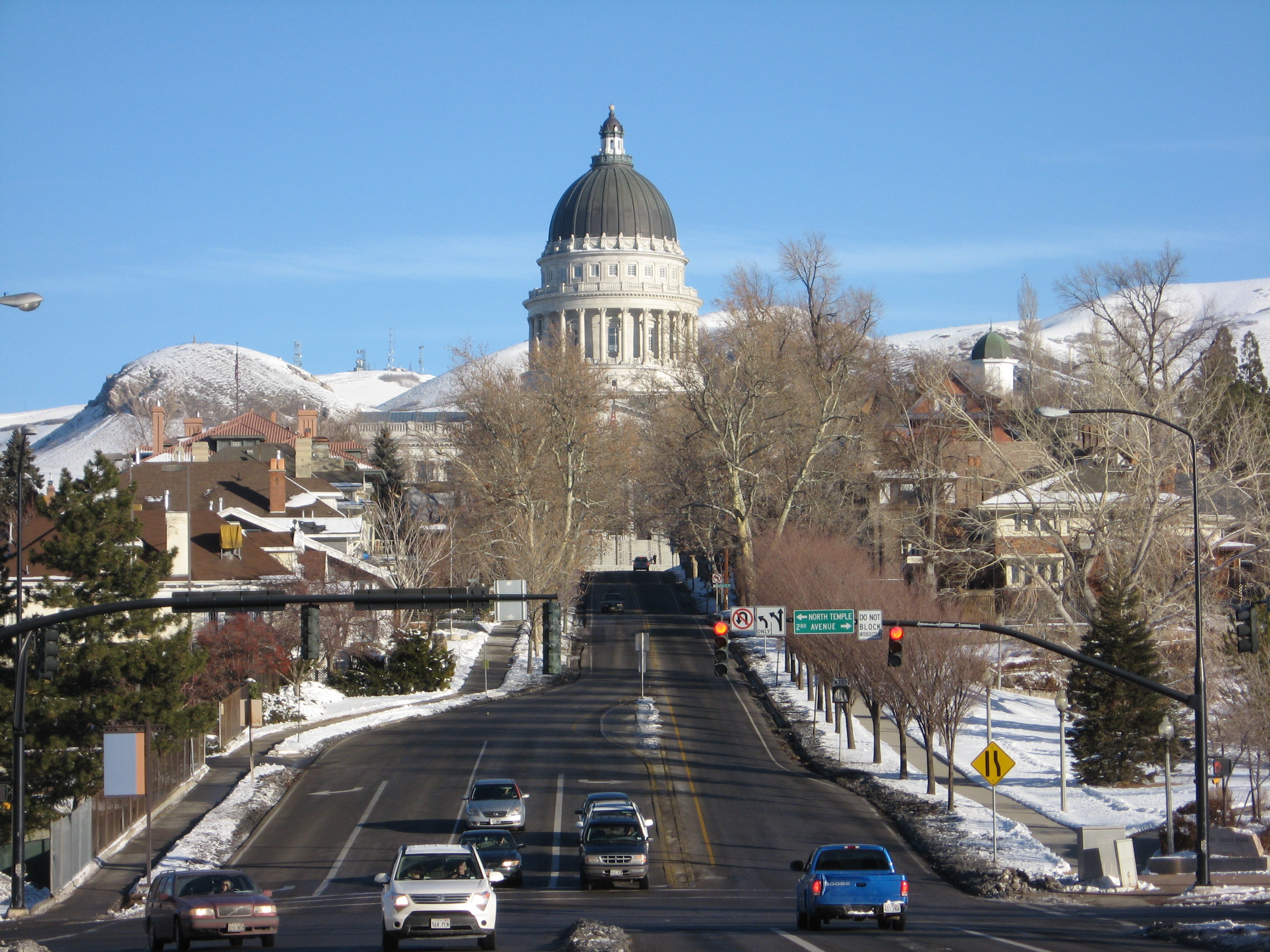
State Route 184 was a state highway in the U.S. state of Utah. It was a loop that connected U.S. Route 89 (US-89) in Salt Lake City with the Utah State Capitol. The route was originally added to the state highway system in 1935 as part of SR-181, and SR-184 was created in 1963 as a split from that route. It would remain until 2007, when it was deleted in a series of highway realignments in the Salt Lake City area. However, its route remains on the state highway system as SR-186. Route description SR-184 began in Downtown Salt Lake City at the intersection of State Street, North Temple, and 2nd Avenue. At the time, US-89 went west and south from this intersection, though it has since been rerouted. SR-184 left downtown on State Street, climbing Capitol Hill and entering the neighborhood of the same name before turning west at 300 North, just south of the Utah State Capitol. SR-184 continued to follow the south and west side of the capitol grounds, turning northeast on ... [...More Info...] [...Related Items...] OR: [Wikipedia] [Google] [Baidu] |
Salt Lake City
Salt Lake City (often shortened to Salt Lake and abbreviated as SLC) is the Capital (political), capital and List of cities and towns in Utah, most populous city of Utah, United States. It is the county seat, seat of Salt Lake County, Utah, Salt Lake County, the most populous county in Utah. With a population of 200,133 in 2020, the city is the core of the Salt Lake City metropolitan area, which had a population of 1,257,936 at the 2020 census. Salt Lake City is further situated within a larger metropolis known as the Salt Lake City–Provo–Orem Combined Statistical Area, Salt Lake City–Ogden–Provo Combined Statistical Area, a corridor of contiguous urban and suburban development stretched along a segment of the Wasatch Front, comprising a population of 2,746,164 (as of 2021 estimates), making it the 22nd largest in the nation. It is also the central core of the larger of only two major urban areas located within the Great Basin (the other being Reno, Nevada). Salt Lake C ... [...More Info...] [...Related Items...] OR: [Wikipedia] [Google] [Baidu] |
Salt Lake County, Utah
Salt Lake County is located in the U.S. state of Utah. As of the 2020 United States Census, the population was 1,185,238, making it the most populous county in Utah. Its county seat and largest city is Salt Lake City, the state capital. The county was created in 1850. Salt Lake County is the 37th most populated county in the United States and is one of four counties in the Rocky Mountains to make it into the top 100. (Others being Denver County and El Paso County, Colorado and Clark County, Nevada.) Salt Lake County is the only county of the first class in Utah - under the Utah Code (Title 17, Chapter 50, Part 5) is a county with a population of 700,000 or greater. Salt Lake County occupies the Salt Lake Valley, as well as parts of the surrounding mountains, the Oquirrh Mountains to the west and the Wasatch Range to the east (essentially the entire Jordan River watershed north of the Traverse Mountains). In addition, the northwestern section of the county includes part of th ... [...More Info...] [...Related Items...] OR: [Wikipedia] [Google] [Baidu] |
State Highway
A state highway, state road, or state route (and the equivalent provincial highway, provincial road, or provincial route) is usually a road that is either ''numbered'' or ''maintained'' by a sub-national state or province. A road numbered by a state or province falls below numbered national highways (Canada being a notable exception to this rule) in the hierarchy (route numbers are used to aid navigation, and may or may not indicate ownership or maintenance). Roads maintained by a state or province include both nationally numbered highways and un-numbered state highways. Depending on the state, "state highway" may be used for one meaning and "state road" or "state route" for the other. In some countries such as New Zealand, the word "state" is used in its sense of a sovereign state or country. By this meaning a state highway is a road maintained and numbered by the national government rather than local authorities. Countries Australia Australia's State Route system covers u ... [...More Info...] [...Related Items...] OR: [Wikipedia] [Google] [Baidu] |
Utah
Utah ( , ) is a state in the Mountain West subregion of the Western United States. Utah is a landlocked U.S. state bordered to its east by Colorado, to its northeast by Wyoming, to its north by Idaho, to its south by Arizona, and to its west by Nevada. Utah also touches a corner of New Mexico in the southeast. Of the fifty U.S. states, Utah is the 13th-largest by area; with a population over three million, it is the 30th-most-populous and 11th-least-densely populated. Urban development is mostly concentrated in two areas: the Wasatch Front in the north-central part of the state, which is home to roughly two-thirds of the population and includes the capital city, Salt Lake City; and Washington County in the southwest, with more than 180,000 residents. Most of the western half of Utah lies in the Great Basin. Utah has been inhabited for thousands of years by various indigenous groups such as the ancient Puebloans, Navajo and Ute. The Spanish were the first Europe ... [...More Info...] [...Related Items...] OR: [Wikipedia] [Google] [Baidu] |
Utah State Capitol
The Utah State Capitol is the house of government for the U.S. state of Utah. The building houses the chambers and offices of the Utah State Legislature, the offices of the Governor, Lieutenant Governor, Attorney General, the State Auditor and their staffs. The capitol is the main building of the Utah State Capitol Complex, which is located on Capitol Hill, overlooking downtown Salt Lake City. The Neoclassical revival, Corinthian style building was designed by architect Richard K.A. Kletting, and built between 1912 and 1916. The building was added to the National Register of Historic Places in 1978. Beginning in 2004, the capitol underwent a major restoration and renovation project. The project added two new buildings to the complex while restoring many of the capitol's public spaces to their original appearance. One of the largest projects during the renovation was the addition of a base isolation system which will allow the building to survive as much as a 7.3 magnitude ear ... [...More Info...] [...Related Items...] OR: [Wikipedia] [Google] [Baidu] |
Utah State Route 181
Utah ( , ) is a state in the Mountain West subregion of the Western United States. Utah is a landlocked U.S. state bordered to its east by Colorado, to its northeast by Wyoming, to its north by Idaho, to its south by Arizona, and to its west by Nevada. Utah also touches a corner of New Mexico in the southeast. Of the fifty U.S. states, Utah is the 13th-largest by area; with a population over three million, it is the 30th-most-populous and 11th-least-densely populated. Urban development is mostly concentrated in two areas: the Wasatch Front in the north-central part of the state, which is home to roughly two-thirds of the population and includes the capital city, Salt Lake City; and Washington County in the southwest, with more than 180,000 residents. Most of the western half of Utah lies in the Great Basin. Utah has been inhabited for thousands of years by various indigenous groups such as the ancient Puebloans, Navajo and Ute. The Spanish were the first Europeans t ... [...More Info...] [...Related Items...] OR: [Wikipedia] [Google] [Baidu] |
Utah State Route 186
State Route 186 (SR-186) is a state highway entirely within Salt Lake City, capital of the U.S. state of Utah. It forms a quarter-beltway connecting US-89 and I-15 leading north from Salt Lake City to I-80 leading east; as such, it effectively forms the missing (non-freeway) quarter of the I-215 belt route around the city, though it does not directly connect to I-215 at the north end. Despite this beltway role, the route passes through downtown Salt Lake City because downtown is built right up to the northern mountains surrounding City Creek Canyon. The portion of the route connecting downtown to I-80 is a high-capacity street heavily used by commuters, especially those travelling to the University of Utah or between downtown and eastern neighborhoods, but the portion on Capitol Hill north of downtown is much narrower and has sharp turns around the Capitol grounds. The roadway runs along Victory Road, Columbus Street, 300 North, State Street, 400 South, 500 South, and Foothill D ... [...More Info...] [...Related Items...] OR: [Wikipedia] [Google] [Baidu] |
Utah State Capitol Seen From State Street
Utah ( , ) is a state in the Mountain West subregion of the Western United States. Utah is a landlocked U.S. state bordered to its east by Colorado, to its northeast by Wyoming, to its north by Idaho, to its south by Arizona, and to its west by Nevada. Utah also touches a corner of New Mexico in the southeast. Of the fifty U.S. states, Utah is the 13th-largest by area; with a population over three million, it is the 30th-most-populous and 11th-least-densely populated. Urban development is mostly concentrated in two areas: the Wasatch Front in the north-central part of the state, which is home to roughly two-thirds of the population and includes the capital city, Salt Lake City; and Washington County in the southwest, with more than 180,000 residents. Most of the western half of Utah lies in the Great Basin. Utah has been inhabited for thousands of years by various indigenous groups such as the ancient Puebloans, Navajo and Ute. The Spanish were the first Eu ... [...More Info...] [...Related Items...] OR: [Wikipedia] [Google] [Baidu] |


