|
Ust-Belaya
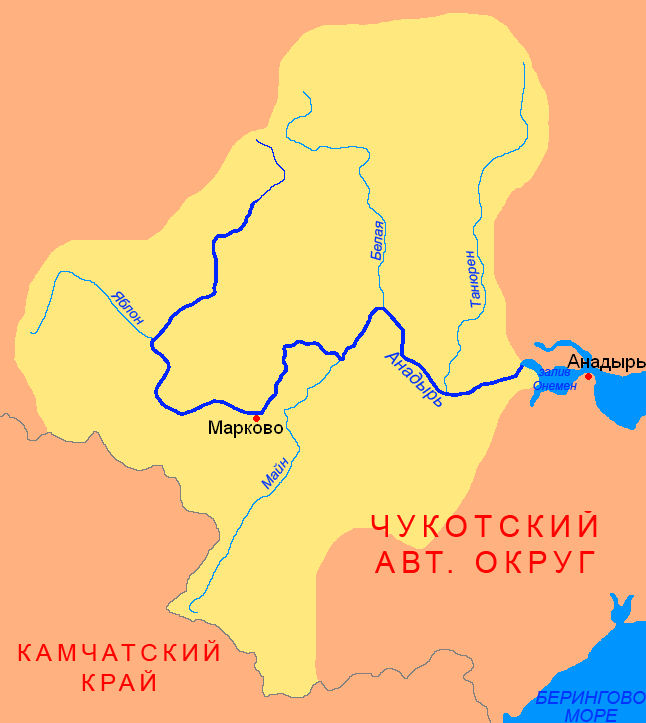
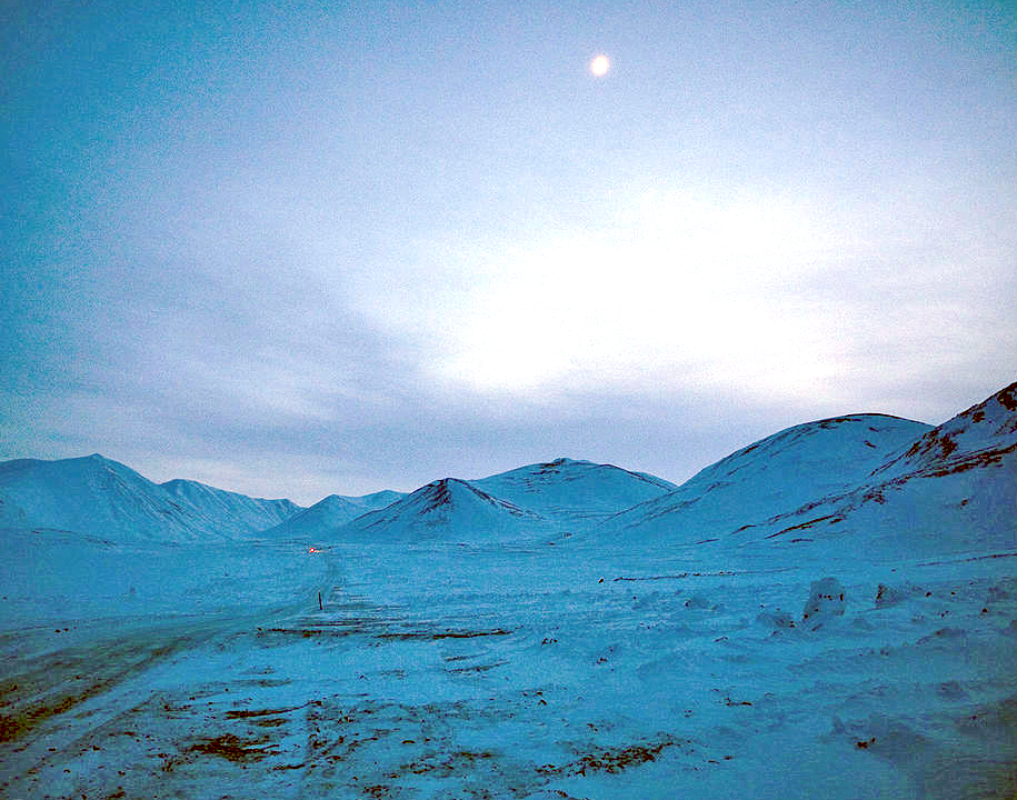
Ust-Belaya (russian: Усть-Бе́лая; ckt, Куулючьын, ''Kuulûč’yn'') is a rural locality (a '' selo'') in Anadyrsky District of Chukotka Autonomous Okrug, Russia, located at the confluence of the Anadyr and the Belaya Rivers.Strogoff, p. 92 Population: Municipally, the settlement is subordinated to Anadyrsky Municipal District and incorporated as Ust-Belaya Rural Settlement. Geography The settlement lies on the banks of the Belaya River (so called because of the contrast between its waters and those of the Anadyr), near to where it flows into the Anadyr River. The Parapol-Belsky Lowlands lie to the west and the Anadyr Lowlands to the east. The village is situated on the northern slopes of the mountain, Gynryretyk (russian: Гынрырэтык, literally meaning "The Guardian"). History The area in the vicinity of the settlement was populated during neolithic times, and a toggled harpoon head found in a grave indicated that there was a viable walrus hu ... [...More Info...] [...Related Items...] OR: [Wikipedia] [Google] [Baidu] |
Anadyrsky District
Anadyrsky District (russian: Ана́дырский райо́н; Chukchi: , ''Kagyrgyn rajon'') is an administrativeLaw #33-OZ and municipalLaw #148-OZ district (raion), one of the six in Chukotka Autonomous Okrug, Russia. It is located in the central and southern parts of the autonomous okrug and borders with Chaunsky District in the northwest, Iultinsky District in the north and northeast, the Gulf of Anadyr in the east, Koryak Okrug in the south, and with Bilibinsky District in the west and northwest. It also completely surrounds the territory of the town of okrug significance of Anadyr. The area of the district is .Official website of Anadyrsky DistrictGeneral information Its administrative center is the town of Anadyr (which is not administratively a part of the district). Population: In terms of area, this is the largest district in the autonomous okrug. The district is located in a mountainous region, the peaks of which provide the catchment areas for the Anadyr River and ... [...More Info...] [...Related Items...] OR: [Wikipedia] [Google] [Baidu] |
Markovo, Chukotka Autonomous Okrug
Markovo (russian: Ма́рково; Chukchi: , ''Ujvyn'' / ''Gujgun'', lit. ''wooden hut'';Leontyev and Novikova, p. 329 Koryak: , ''Vujvәn'', lit. ''big village'') is a rural locality (a '' selo'') in Anadyrsky District of Chukotka Autonomous Okrug, Russia, located near the head of small-boat navigation of the Anadyr River. As of the 2010 Census, its population was 809.The results of the 2010 Census and the 2018 estimate are given for Markovo Rural Settlement, a municipal formation of Anadyrsky Municipal District. According to Law #148-OZ, Markovo is the only inhabited locality on the territory of Markovo Rural Settlement. A small locality now—albeit still quite large by Chukotkan standards—Markovo had historically been an important trade hub during the early period of Cossack exploration. Geography Markovo is situated in the middle reaches of the Anadyr River, the largest waterway in Chukotka, in a lowland region with a unique microclimate, surrounded by the ... [...More Info...] [...Related Items...] OR: [Wikipedia] [Google] [Baidu] |
Belaya River (Chukotka)
The Belaya (russian: Бе́лая, in its upper course Юрумкувеем ''Yurumkuveyem'') Great Soviet Encyclopedia is a south-flowing tributary of the Anadyr (river), Anadyr in the Chukotka Autonomous Okrug administrative region of Russia. Course The source of the Yurumkuveyem is in the northern Anadyr Mountains. Its main tributaries are the Bolshoy Pykarvaam, Chaavaam and Bolshaya Osinovaya from the left, and the Enmyvaam, which drains Lake Elgygytgyn, from the right. Its basin is and its length is (487 km from its furthest source, that of the Bolshoy Pykarvaam). Downstream from its confluence with the Enmyvaam it is named ''Belaya''. The Belaya flows through sparsely populated areas of Chukotka, flows southwards across the eastern edge of the Anadyr Highlands and the Pekulney Range, and joins with the Enmyvaam i ...[...More Info...] [...Related Items...] OR: [Wikipedia] [Google] [Baidu] |
Tenevil
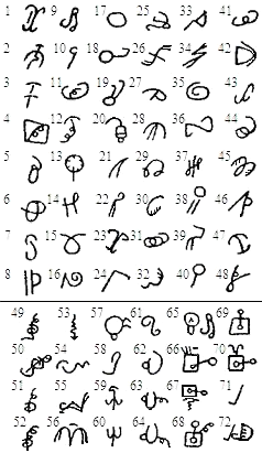
{{more citations needed, date=February 2015 Tenevil (russian: Теневиль) (ca. 1890–1943?) was a Chukchi reindeer herder, living in the tundra near the settlement of Ust-Belaya in Russian province of Chukotka. Around 1927 or 1928 he independently invented a writing system for the Chukchi language. It has never been established with certainty whether the symbols in this writing system were ideograms/pictograms or whether the system was logogram-based. Researchers have noted the abstract character of the symbols, which may be an indirect evidence that this writing system is entirely Tenevil's invention. Tenevil's writing system was first described by the Russian ethnographer and writer Waldemar Bogoras in 1930. The writing system was never widely known: it was used entirely within Tenevil's family encampment. Apart from Tenevil himself, the writing system was used by his son, with whom he exchanged messages during shifts away at the reindeer pastures. Tenevil wrote his ... [...More Info...] [...Related Items...] OR: [Wikipedia] [Google] [Baidu] |
Anadyr River
The Anadyr (russian: Ана́дырь; Yukaghir: Онандырь; ckt, Йъаайваам) is a river in the far northeast of Siberia which flows into the Gulf of Anadyr of the Bering Sea and drains much of the interior of Chukotka Autonomous Okrug. Its basin corresponds to the Anadyrsky District of Chukotka. Geography The Anadyr is long and has a basin of . It is frozen from October to late May and has a maximum flow in June with the snowmelt. It is navigable in small boats for about to near Markovo. West of Markovo it is in the Anadyr Highlands (moderate mountains and valleys with a few trees) and east of Markovo it moves into the Anadyr Lowlands (very flat treeless tundra with lakes and bogs). The drop from Markovo to the sea is less than . It rises at about 67°N latitude and 171°E longitude in the Anadyr Highlands, near the headwaters of the Maly Anyuy, flows southwest receiving the waters of the rivers Yablon and Yeropol, turns east around the Shchuchy Range an ... [...More Info...] [...Related Items...] OR: [Wikipedia] [Google] [Baidu] |
Anadyr Lowlands
The Anadyr Lowlands (russian: Ана́дырская ни́зменность) are a low alluvial plain located in the Chukotka Autonomous Okrug, Far Eastern Federal District, Russia. Geography The lowlands are crossed by the Anadyr River in the middle and the Velikaya in the south. They are bound by the Pekulney Range of the Chukotka Mountains to the northwest, west of which lie the Parapol-Belsky Lowlands (Парапольско-Бельская низменность) beyond which rise the Anadyr Highlands, and by the Rarytkin and Ukvushvuynen ranges of the Koryak Mountains to the south. The mouth of the Anadyr River flows into the Anadyr Gulf of the Bering Sea to the east. The harbor city of Anadyr is located by the mouth on the shore of Onemen Bay in the estuarine area of the river.Google Earth The lowlands are a flat, mostly marshy tundra plain with a maximum height of above sea level. The whole area is dotted with lakes, the largest of which is Lake Krasnoye.Ана́� ... [...More Info...] [...Related Items...] OR: [Wikipedia] [Google] [Baidu] |
Kupol Gold Mine
Kupol Gold Mine is a combination underground and open pit gold and silver mine located in the Bilibinsky District of the Chukotka Autonomous Okrug of Russia, at the eastern end of the Anyuy Range. The mine, which produces gold and silver doré bars, is 100% owned by Toronto based Kinross Gold. The name Kupol (russian: купол), literally means "dome". History Development of the mine began in 2005 on a property owned by the Bema Gold Corporation. Bema Gold financed construction through a series of loans totaling $425 million. Bayerische Hypo und Vereinsbank and Société Générale provided $250 million, and $150 million was provided by an international consortium made up of Caterpillar, Export Development Canada, International Finance Corporation, and others. Bema Gold's corporate office loaned the remaining $25 million. In addition to the loans, the government of Chukotka Autonomous Okrug provided an additional $18 million to support construction. In 2007, Kinross purchased ... [...More Info...] [...Related Items...] OR: [Wikipedia] [Google] [Baidu] |
Chukchi People
The Chukchi, or Chukchee ( ckt, Ԓыгъоравэтԓьэт, О'равэтԓьэт, ''Ḷygʺoravètḷʹèt, O'ravètḷʹèt''), are a Siberian indigenous people native to the Chukchi Peninsula, the shores of the Chukchi Sea and the Bering Sea region of the Arctic Ocean all within modern Russia. They speak the Chukchi language. The Chukchi originated from the people living around the Okhotsk Sea. According to several studies on genomic research conduct from 2014 to 2018, the Chukchi are one of the Indigenous peoples of Siberia, they are also the closest Asiatic relatives of the indigenous peoples of the Americas as well as of the Ainu people and other East Asian people, being the descendants of settlers who did not cross the Bering Strait or settled the Japanese archipelago. Cultural history The majority of Chukchi reside within Chukotka Autonomous Okrug, but some also reside in the neighboring Sakha Republic to the west, Magadan Oblast to the southwest, and Kamchatka K ... [...More Info...] [...Related Items...] OR: [Wikipedia] [Google] [Baidu] |
Kolkhoz
A kolkhoz ( rus, колхо́з, a=ru-kolkhoz.ogg, p=kɐlˈxos) was a form of collective farm in the Soviet Union. Kolkhozes existed along with state farms or sovkhoz., a contraction of советское хозяйство, soviet ownership or state ownership, sovetskoye khozaystvo. Russian plural: ''sovkhozy''; anglicized plural: ''sovkhozes''. These were the two components of the socialized farm sector that began to emerge in Soviet agriculture after the October Revolution of 1917, as an antithesis both to the feudal structure of impoverished serfdom and aristocratic landlords and to individual or family farming. The 1920s were characterized by spontaneous emergence of collective farms, under influence of traveling propaganda workers. Initially, a collective farm resembled an updated version of the traditional Russian "commune", the generic "farming association" (''zemledel’cheskaya artel’''), the Association for Joint Cultivation of Land (TOZ), and finally the kolkhoz. T ... [...More Info...] [...Related Items...] OR: [Wikipedia] [Google] [Baidu] |
Neolithic
The Neolithic period, or New Stone Age, is an Old World archaeological period and the final division of the Stone Age. It saw the Neolithic Revolution, a wide-ranging set of developments that appear to have arisen independently in several parts of the world. This "Neolithic package" included the introduction of farming, domestication of animals, and change from a hunter-gatherer lifestyle to one of settlement. It began about 12,000 years ago when farming appeared in the Epipalaeolithic Near East, and later in other parts of the world. The Neolithic lasted in the Near East until the transitional period of the Chalcolithic (Copper Age) from about 6,500 years ago (4500 BC), marked by the development of metallurgy, leading up to the Bronze Age and Iron Age. In other places the Neolithic followed the Mesolithic (Middle Stone Age) and then lasted until later. In Ancient Egypt, the Neolithic lasted until the Protodynastic period, 3150 BC.Karin Sowada and Peter Grave. Egypt in th ... [...More Info...] [...Related Items...] OR: [Wikipedia] [Google] [Baidu] |
Chukotka Autonomous Okrug
Chukotka (russian: Чуко́тка), officially the Chukotka Autonomous Okrug,, ''Čukotkakèn avtonomnykèn okrug'', is the easternmost federal subjects of Russia, federal subject of Russia. It is an autonomous okrug situated in the Russian Far East, and shares a border with the Sakha, Sakha Republic to the west, Magadan Oblast to the south-west, and Kamchatka Krai to the south. Anadyr (town), Anadyr is the largest types of inhabited localities in Russia, town and the administrative center, capital, and the easternmost settlement to have town status in Russia. Chukotka is primarily populated by ethnic Russians, Chukchi people, Chukchi, and other Indigenous peoples of Siberia, indigenous peoples. It is the only autonomous okrug in Russia that is not included in, or subordinate to, another federal subject, having separated from Magadan Oblast in 1992. It is home to Lake Elgygytgyn, an impact crater lake, and Anyuyskiy, an extinct volcano. The village of Uelen is the easternmos ... [...More Info...] [...Related Items...] OR: [Wikipedia] [Google] [Baidu] |


