|
Usora (region)
Usora ( la, Vozora, hu, Ózora) was important '' zemlja'' (; feudalna oblast ) of the medieval Bosnian state, first banate and later kingdom, although it also had some periods outside its jurisdiction and royal authority, when it was connected with neighboring banates of Slavonia, or Mačva at times. The administrative seat of this ''zemlja'' was Srebrenik, which also served as residence for its rulers for entire period of existence of the medieval Bosnian state. It took its name from the river Usora. Ethimology The name of the land of Usora derives from the eponymous river, which runs through its territories for approximately 80 kilometers, in direction south-southwest to north-northeast, and spills into the river Bosna just south of town of Doboj. Geography and location Usora was the northernmost Bosnian land (''zemlja''), occupying very fertile Pannonian Plain, and its geographical location roughly correspond to modern-day Northern Bosnia gravitating toward Posavina. I ... [...More Info...] [...Related Items...] OR: [Wikipedia] [Google] [Baidu] |
Ottoman Empire
The Ottoman Empire, * ; is an archaic version. The definite article forms and were synonymous * and el, Оθωμανική Αυτοκρατορία, Othōmanikē Avtokratoria, label=none * info page on book at Martin Luther University) // CITED: p. 36 (PDF p. 38/338) also known as the Turkish Empire, was an empire that controlled much of Southeast Europe, Western Asia, and Northern Africa between the 14th and early 20th centuries. It was founded at the end of the 13th century in northwestern Anatolia in the town of Söğüt (modern-day Bilecik Province) by the Turkoman tribal leader Osman I. After 1354, the Ottomans crossed into Europe and, with the conquest of the Balkans, the Ottoman beylik was transformed into a transcontinental empire. The Ottomans ended the Byzantine Empire with the conquest of Constantinople in 1453 by Mehmed the Conqueror. Under the reign of Suleiman the Magnificent, the Ottoman Empire marked the peak of its power and prosperity, as well a ... [...More Info...] [...Related Items...] OR: [Wikipedia] [Google] [Baidu] |
Bosnia (region)
Bosnia ( sh-Latn-Cyrl, separator=" / ", Bosna, Босна, ) is the northern region of Bosnia and Herzegovina, encompassing roughly 81% of the country; the other region, the southern part, is Herzegovina. The two regions have formed a geopolitical entity since medieval times, and the name "Bosnia" commonly occurs in historical and geopolitical senses as generally referring to both regions (Bosnia and Herzegovina). The official use of the combined name started only in the late period of Ottoman rule. Geography Bosnia lies mainly in the Dinaric Alps, ranging to the southern borders of the Pannonian plain, with the rivers Sava and Drina marking its northern and eastern borders. The area of Bosnia comprises approximately 39,021 km2, and makes up about 80% of the territory of the present-day state of Bosnia and Herzegovina. There are no true borders between the region of Bosnia and the region of Herzegovina. Unofficially, Herzegovina is south of the mountain Ivan planina. Acco ... [...More Info...] [...Related Items...] OR: [Wikipedia] [Google] [Baidu] |
Žepče
Žepče ( sr-cyrl, Жепче) is a town and municipality located in Zenica-Doboj Canton of the Federation of Bosnia and Herzegovina, an entity of Bosnia and Herzegovina. It is situated in central Bosnia and Herzegovina, between Doboj and Zenica. As of 2013, it has a population of 30,219 inhabitants. The river Bosna flows through this city. Near within the town, there are 14 mineral water springs. Žepče is within the vicinity of the Lasva valley and thus is surrounded by mountains. History The town was first mentioned in 1458 in a charter issued by the Bosnian king Stjepan Tomašević, ''"... Pissanna Žepču va ljetu 1458. oktombrija 14. dan.''" (Written in Žepče in the year 1458. 14.day of October) The city would see combat during the Bosnian War, as HVO forces would launch an operation against ARBiH over complete control of the city on the 24th of June, 1993. After the Dayton Agreement in 1995, the city would end up becoming a part of the Federation of Bosnia and Her ... [...More Info...] [...Related Items...] OR: [Wikipedia] [Google] [Baidu] |
Sava
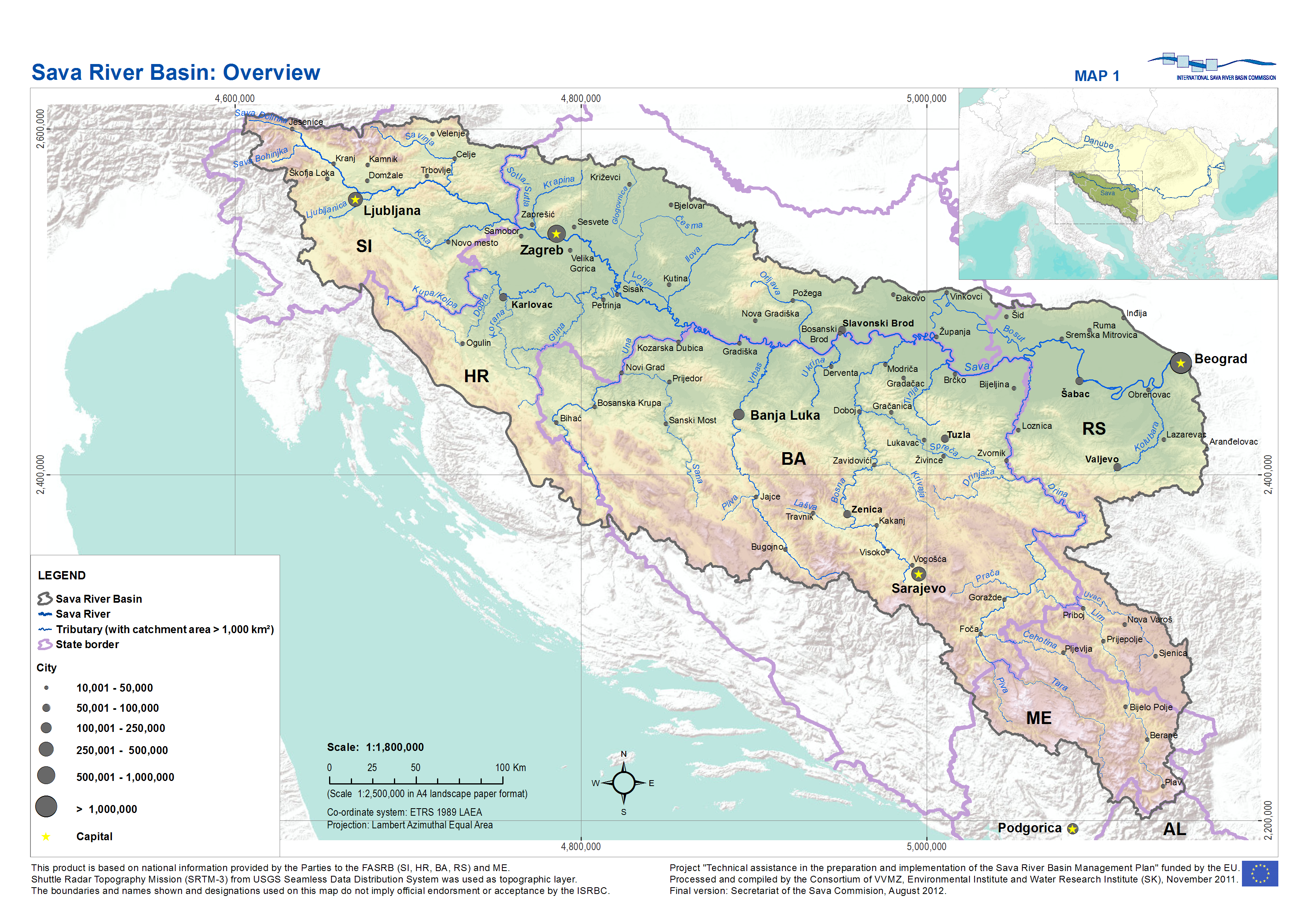
The Sava (; , ; sr-cyr, Сава, hu, Száva) is a river in Central and Southeast Europe, a right-bank and the longest tributary of the Danube. It flows through Slovenia, Croatia and along its border with Bosnia and Herzegovina, and finally through Serbia, feeding into the Danube in its capital, Belgrade. The Sava forms the main northern limit of the Balkan Peninsula, and the southern edge of the Pannonian Plain. The Sava is long, including the Sava Dolinka headwater rising in Zelenci, Slovenia. It is the largest tributary of the Danube by volume of water, and second-largest after the Tisza in terms of catchment area () and length. It drains a significant portion of the Dinaric Alps region, through the major tributaries of Drina, Bosna, Kupa, Una, Vrbas, Lonja, Kolubara, Bosut and Krka. The Sava is one of the longest rivers in Europe and among the longest tributaries of another river. The population in the Sava River basin is estimated at 8,176,000, and is shared by ... [...More Info...] [...Related Items...] OR: [Wikipedia] [Google] [Baidu] |
Lukavac
Lukavac ( sr-cyrl, Лукавац) is a city located in Tuzla Canton of the Federation of Bosnia and Herzegovina, an entity of Bosnia and Herzegovina. According to the 2013 census, the town has a population of 12,061 inhabitants, with 44,520 inhabitants in the city. Geography Lukavac covers an area of 352,66 km2. It shares borders with cities and municipalities of: Tuzla, Živinice, Banovići, Zavidovići, Maglaj, Petrovo, Gračanica and Srebrenik. Apart from the town, the city comprises the following villages: Babice Donje • Babice Gornje • Berkovica • Bikodže • Bistarac Donji • Bistarac Gornji • Bokavići • Borice • Brijesnica Donja • Brijesnica Gornja • Caparde • Cerik • Crveno Brdo • Devetak • Dobošnica • Gnojnica • Huskići • Jaruške Donje • Jaruške Gornje • Kalajevo • Komari • Krtova • Kruševica • Lukavac • Lukavac Gornji • Mičijevići • Milino Selo • Modrac • Orahovica • Poljice • Prline • ... [...More Info...] [...Related Items...] OR: [Wikipedia] [Google] [Baidu] |
Prnjavor, Bosnia And Herzegovina
Prnjavor ( sr-cyr, Прњавор, ) is a town and municipality located in Republika Srpska, an entity of Bosnia and Herzegovina, between cities of Banja Luka and Doboj. According to the 2013 census, the town has a population of 8,120 inhabitants, with 35,956 inhabitants in the municipality. Geography Physical geography The municipality is located in the basin of the Ukrina river and is characterized by a mostly lowland hilly terrain configuration with the highest peak of 594m (mountain Ljubić). The Municipality of Prnjavor is shielded on all sides by low mountains such as Ljubić (south) and Motajica (north). The town of Prnjavor is located at an altitude of 185m. Other thant the river Ukrina which forms in the Municipality of Prnjavor by merging of the Big and Small Ukrina near the village of Kulaši, there are also the rivers of Vijaka and Lišnja and various other streams. On the river Vijaka in the foothills of Ljubić there is a man made lake Drenova and further downst ... [...More Info...] [...Related Items...] OR: [Wikipedia] [Google] [Baidu] |
Posavina
Posavina ( sr-cyr, Посавина) is a geographical region that stretches along the Sava river, encompassing only the inner areas of the Sava river basin, that are adjacent or near to the Sava river itself, namely catch region spanning from the Julian Alps in the northwest to the confluence with the Danube in the southeast. It passes through several countries of former Yugoslavia, namely Slovenia, Croatia, Bosnia and Herzegovina and Serbia. In Slovene, the term Posavina is not used to describe the parts of Slovenia that lie by the Sava river. Instead, the terms Posavje and Zasavje are used. Geography Geography of the Posavina region is defined by geological features of the central (inner) zones of the Sava river basin, that are near or adjacent to the Sava river itself. The region is stretched along the Sava river, that flows from west to east, connecting valleys and plains in transitional regions between the Dinaric Mountains and the Pannonian Plain. Geographical borders o ... [...More Info...] [...Related Items...] OR: [Wikipedia] [Google] [Baidu] |
Pannonian Plain
The Pannonian Basin, or Carpathian Basin, is a large basin situated in south-east Central Europe. The geomorphological term Pannonian Plain is more widely used for roughly the same region though with a somewhat different sense, with only the lowlands, the plain that remained when the Pliocene Epoch ''Pannonian Sea'' dried out. It is a geomorphological subsystem of the Alps-Himalaya system, specifically a sediment-filled back-arc basin which spread apart during the Miocene. The plain or basin is diagonally bisected by the Transdanubian Mountains, separating the larger Great Hungarian Plain (including the Eastern Slovak Lowland) from the Little Hungarian Plain. It forms a topographically discrete unit set in the European landscape, surrounded by imposing geographic boundaries—the Carpathian Mountains and the Alps. The Rivers Danube and Tisza divide the basin roughly in half. It extends roughly between Vienna in the northwest, Košice in the northeast, Zagreb in the southwe ... [...More Info...] [...Related Items...] OR: [Wikipedia] [Google] [Baidu] |
Doboj
Doboj ( sr-cyrl, Добој, ) is a city located in Republika Srpska, an entity of Bosnia and Herzegovina. It is situated on the banks of Bosna river, in the northern region of the Republika Srpska. As of 2013, it has a population of 71,441 inhabitants. Doboj is the largest national railway junction and the operational base of the Railways Corporation of Bosnia and Herzegovina is located in Doboj. It is one of the oldest cities in Bosnia and Herzegovina and the most important urban center in northern Republika Srpska. Geography Prior to the war in Bosnia the municipality of the same name had a larger surface area. The largest part of the pre-war municipality is part of the Republika Srpska, including the city itself, (the Doboj Region). The southern rural areas are part of the Zenica-Doboj Canton of the Federation of Bosnia and Herzegovina, and the eastern rural part of the municipality is part of the Tuzla Canton, also in the Federation of Bosnia and Herzegovina. The parts ... [...More Info...] [...Related Items...] OR: [Wikipedia] [Google] [Baidu] |
Bosna (river)
The Bosna () is the third longest river in Bosnia and Herzegovina, and is considered one of the country's three major internal rivers, along with the Neretva and the Vrbas. The other three major rivers of Bosnia and Herzegovina are the Una, to the northwest; the Sava, to the north, and the Drina, to the east. This river is the namesake of Bosnia. The river Bosna flows for . The river is possibly mentioned for the first time during the 1st century AD by Roman historian Marcus Velleius Paterculus under the name ''Bathinus flumen''. Another basic source that is associated with the hydronym ''Bathinus'' is the Salonitan inscription of the governor of Dalmatia, Publius Cornelius Dolabella, where it is said that the ''Bathinum'' river divides the Breuci from the Osseriates. And also by the name of Basante. There was also the name Bason on the map ''From Istanbul to Vienna'' along the Danube and the Black Sea — a river-centric map by the Venetian cartographer Stefano Scolari, ... [...More Info...] [...Related Items...] OR: [Wikipedia] [Google] [Baidu] |
Usora (river)
Usora ( sr-cyrl, Усора) is a river in central-northern Bosnia and Herzegovina. It begins at the confluence of two smaller Usora rivers, Mala Usora and Velika Usora, at the town of Teslić. Usora runs for some 20 km northeast of Teslić, and becomes a left tributary of the Bosna River, south of Doboj Doboj ( sr-cyrl, Добој, ) is a city located in Republika Srpska, an entity of Bosnia and Herzegovina. It is situated on the banks of Bosna river, in the northern region of the Republika Srpska. As of 2013, it has a population of 71,441 .... Its total length (including Velika Usora) is . References External links * Rivers of Bosnia and Herzegovina Zenica-Doboj Canton Teslić {{BosniaHerzegovina-river-stub ... [...More Info...] [...Related Items...] OR: [Wikipedia] [Google] [Baidu] |


