|
Uists
"Uist" is a group of six islands and are part of the Outer Hebridean Archipelago, part of the Outer Hebrides of Scotland. North Uist and South Uist ( or ; gd, Uibhist ) are two of the islands and are linked by causeways running via the isles of Benbecula and Grimsay. From south to north, the inhabited islands in the island group are (Eriskay), (South Uist), Grimsay (South), (Benbecula), (Flodaigh), ( Grimsay (North)), , (North Uist), (Baleshare) and ( Berneray). The islands, collectively, have a population of 4,723. Major settlements The main settlements in Uist are: South Uist * (Daliburgh) * (Lochboisdale) * ( Snishvale) * (Stoneybridge) * (Eochar) * ( Polochar) * (Eriskay) Benbecula * (Balivanich) * ( Creagorry) * ( Liniclate) North Uist * (Carinish) * (Bayhead) * (Sollas) * (Lochmaddy) * (Balemore) 16th century Geography Writing in 1549, Sir Donald Monro, High Dean of the Isles stated of "Ywst" that it was a fertile country full of high hi ... [...More Info...] [...Related Items...] OR: [Wikipedia] [Google] [Baidu] |
Outer Hebrides
The Outer Hebrides () or Western Isles ( gd, Na h-Eileanan Siar or or ("islands of the strangers"); sco, Waster Isles), sometimes known as the Long Isle/Long Island ( gd, An t-Eilean Fada, links=no), is an island chain off the west coast of mainland Scotland. The islands are geographically coextensive with , one of the 32 unitary council areas of Scotland. They form part of the archipelago of the Hebrides, separated from the Scottish mainland and from the Inner Hebrides by the waters of the Minch, the Little Minch, and the Sea of the Hebrides. Scottish Gaelic is the predominant spoken language, although in a few areas English speakers form a majority. Most of the islands have a bedrock formed from ancient metamorphic rocks, and the climate is mild and oceanic. The 15 inhabited islands have a total population of and there are more than 50 substantial uninhabited islands. The distance from Barra Head to the Butt of Lewis is roughly . There are various important prehisto ... [...More Info...] [...Related Items...] OR: [Wikipedia] [Google] [Baidu] |
North Uist
North Uist ( gd, Uibhist a Tuath; sco, North Uise) is an island and community in the Outer Hebrides of Scotland. Etymology In Donald Munro's ''A Description of the Western Isles of Scotland Called Hybrides'' of 1549, North Uist, Benbecula and South Uist are described as one island of ''Ywst'' (Uist). Starting in the south of this 'island', he described the division between South Uist and Benbecula where "the end heirof the sea enters, and cuts the countrey be ebbing and flowing through it". Further north of Benbecula he described North Uist as "this countrey is called Kenehnache of Ywst, that is in Englishe, the north head of Ywst".''A Description of the Western Isles of Scotland Called Hybrides''; Monro, Donald, 1549 Some have taken the etymology of Uist from Old Norse, meaning "west", much like Westray in Orkney. Another speculated derivation of Uist from Old Norse is ', derived from ' meaning "an abode, dwelling, domicile". A Gaelic etymology is also possible, with ' meanin ... [...More Info...] [...Related Items...] OR: [Wikipedia] [Google] [Baidu] |
South Part Of Outer Hebrides By Sentinel-2
South is one of the cardinal directions or compass points. The direction is the opposite of north and is perpendicular to both east and west. Etymology The word ''south'' comes from Old English ''sūþ'', from earlier Proto-Germanic ''*sunþaz'' ("south"), possibly related to the same Proto-Indo-European root that the word ''sun'' derived from. Some languages describe south in the same way, from the fact that it is the direction of the sun at noon (in the Northern Hemisphere), like Latin meridies 'noon, south' (from medius 'middle' + dies 'day', cf English meridional), while others describe south as the right-hand side of the rising sun, like Biblical Hebrew תֵּימָן teiman 'south' from יָמִין yamin 'right', Aramaic תַּימנַא taymna from יָמִין yamin 'right' and Syriac ܬܰܝܡܢܳܐ taymna from ܝܰܡܝܺܢܳܐ yamina (hence the name of Yemen, the land to the south/right of the Levant). Navigation By convention, the ''bottom or down-facing side'' of a ... [...More Info...] [...Related Items...] OR: [Wikipedia] [Google] [Baidu] |
Donald Monro (Dean)
Donald Monro (or Munro) ( fl. 1526–1574) was a Scottish clergyman, who wrote an early and historically valuable description of the Hebrides and other Scottish islands and enjoyed the honorific title of "Dean of the Isles". Origins Donald Monro was born early in the 16th century, the eldest of the six sons of Alexander Munro of Kiltearn, by Janet, daughter of Farquhar Maclean of Dochgarroch. His father was a grandson of George Munro, 10th Baron of Foulis (Chief of the Clan Munro)Alexander Ross, ''The Reverend Donald Munro, M.A., High Dean of the Isles'', in The Celtic Magazine (volume 9, 1884), at pages 142 to 144. and his maternal grandfather was Farquhar MacLean of Dochgarroch, (''Fearchar Mac Eachainn'') Bishop of the Isles from 1529 to 1544.MacLeod (2004) p. 23 On Farquhar's resignation the bishopric passed to his son, and Donald Monro's uncle, Roderick MacLean (''Ruaidhri Mac Gill-Eathain''). Career Monro became the vicar of Snizort and Raasay in 1526MacLeod (2004) p. 2 ... [...More Info...] [...Related Items...] OR: [Wikipedia] [Google] [Baidu] |
Lochmaddy
Lochmaddy ( gd, Loch nam Madadh, "Loch of the Hounds") is the administrative centre of North Uist in the Outer Hebrides, Scotland. ''Na Madaidhean'' (the wolves/hounds) are rocks in the bay after which the loch, and subsequently the village, are named. Lochmaddy is within the parish of North Uist. Geography Lochmaddy lies on the sea loch of that name and, due to the rocky nature of the coast, is the only settlement of any size on the east coast. Most of the island's settlements are on the west coast. Lochmaddy is at the eastern end of the A865 and close to the eastern end of the A867; these are the only two main roads on the island. History Virtually the first mention anywhere of Lochmaddy is a complaint of "piracie and murder" in a report dated 1616: "Lochmaldie on the coast of Uist is a rendezvous for pirates" it said. The coves and inlets around the village were ideal hiding places for raiding ships stocked with fine goods bound for the clan chiefs of the time, and contraba ... [...More Info...] [...Related Items...] OR: [Wikipedia] [Google] [Baidu] |
Sollas
Sollas ( gd, Solas) is a small crofting township on the northern coast of the island of North Uist, Scotland. History The Battle of Sollas From Sollas, the road that heads towards Bayhead is known as the ''Committee Road''. It is called this as it was organised by a committee charged with providing relief to the Highland Potato Famine in the 1840s. The Battle of Sollas took place in 1849 during the time of the Highland Clearances. In 1849, Lord Macdonald decided to evict between 600 and 700 people from Sollas. At the time the people were suffering from several years of potato famine. The notices of ejection were served on the tenants on 15 May 1849. They asked for a delay in order to use their cattle and other effects to their best advantage, but were given no answer. Many of them were soon turned out of their houses and their property seized. It was now the month of July and far too late for them to set out for Canada as the cold winter would be setting in when they arrived, ... [...More Info...] [...Related Items...] OR: [Wikipedia] [Google] [Baidu] |
Bayhead
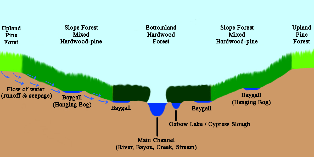
A bayhead or baygall is a specific type of wetland or swamp habitat.Watson, Geraldine Ellis (2006) Big Thicket Plant Ecology: An Introduction, Third Edition (Temple Big Thicket Series #5). University of North Texas Press. 152 pp. Natural Communities of Louisiana:Bayhead Swamp/Forested Seep'. Louisiana Department of Wildlife and Fisheries. Retrieved 7 July 2020. The name ''baygall'' is derived from sweetbay magnolia (''Magnolia virginiana'') and sweet gallberry holly (''Ilex coriacea'').Ajilvsgi, Geyata (1979) Wild Flowers of the Big Thicket: East Texas, and Western Louisiana. Texas A&M University Press. College Station, Texas 361 pp. Baygalls are recognized as a discrete ecosystem by ecologists and the swamps have been described as "distinct wetland communities in the Natural Communities of Louisiana". Baygall swamps are most often found in the low lying margins of floodplains and bottomlands with little or poor drainage to the main creek, bayou, or river channel. Baygall or bayh ... [...More Info...] [...Related Items...] OR: [Wikipedia] [Google] [Baidu] |
Carinish
Carinish ( gd, Càirinis), is a hamlet on North Uist, in the Outer Hebrides, Scotland. It is in the south of the island, about from the causeway to Benbecula. The hamlet is known for the Carinish Stone Circle and the Trinity Temple. Carinish is within the parish of North Uist and is situated on the A865. History Carinish Stone Circle Carinish Stone Circle is not in good condition – it has the A865 main road running almost through the middle of it. About 50 metres to the north, a Neolithic settlement was found. Trinity Temple Trinity Temple or ''Teampall na Trionad'' is the ruins of a 13th-century Augustinian nunnery and "college of learning". It is written in the ''Red Book of Clanranald'' that the nunnery was founded by Bethóc, the Prioress of Iona Nunnery and the daughter of Somerled, the ancestor of the Chiefs of Clan MacDougall, the Lords of the Isles, Clan Donald, Clan MacRory, and Clan MacAlister. After probably being enlarged in the late 14th century by Amy Ma ... [...More Info...] [...Related Items...] OR: [Wikipedia] [Google] [Baidu] |
Balivanich
Balivanich ( gd, Baile a' Mhanaich) is a village on the island of Benbecula in the Outer Hebrides off the west coast of Scotland. It is the main centre for Benbecula and the adjacent islands of North Uist, South Uist and several smaller islands. Balivanich is within the parish of South Uist. History The name meaning "town of the monk" possibly relates to a monastery which may have been founded here as early as during the 6th century. ''Teampull Chaluim Chille'', an ancient church dedicated to Columba, might have been part of this monastery; its remains can still be seen south of the village. An airfield to the north, built during World War II, became the control centre for the Hebrides rocket range, established in 1957 at the height of the Cold War. It is now Benbecula Airport. Geography Balivanich is located on the north-west coast of Benbecula in a largely flat area ( above sea level). As of the date of the census on 29 April 2001, the village comprised . Climate A weather st ... [...More Info...] [...Related Items...] OR: [Wikipedia] [Google] [Baidu] |


