|
USS Majaba (AG-43)
USS ''Majaba'' (AG-43/IX-102) was the Design 1049 cargo ship ''Meriden'' built in 1919 by the Albina Engine & Machine Works, Portland, Oregon. All the ships were requisitioned by the United States Shipping Board (USSB) for World War I service. The ship was bought by the E. K. Wood Lumber Co., of San Francisco, California in 1923 and renamed ''El Capitan''. The ship was chartered by the U.S. Navy through the War Shipping Administration (WSA) in April 1942 and commissioned as ''Majaba''. ''Majaba'' was assigned to operations in the South Pacific Ocean and at Guadalcanal she was struck by a torpedo and beached. After salvage, towing, removal of engines and repair at Tulagi the ship served as a barracks, storage ship and repair ship until the end of the war. In October 1945 WSA requisitioned the title from the owner. ''Majaba'' continued service at Tulagi until she was towed to the Philippines in 1945. The ship was redelivered to WSA on 14 March 1946, placed in the reserve fleet at ... [...More Info...] [...Related Items...] OR: [Wikipedia] [Google] [Baidu] |
Philippines
The Philippines (; fil, Pilipinas, links=no), officially the Republic of the Philippines ( fil, Republika ng Pilipinas, links=no), * bik, Republika kan Filipinas * ceb, Republika sa Pilipinas * cbk, República de Filipinas * hil, Republika sang Filipinas * ibg, Republika nat Filipinas * ilo, Republika ti Filipinas * ivv, Republika nu Filipinas * pam, Republika ning Filipinas * krj, Republika kang Pilipinas * mdh, Republika nu Pilipinas * mrw, Republika a Pilipinas * pag, Republika na Filipinas * xsb, Republika nin Pilipinas * sgd, Republika nan Pilipinas * tgl, Republika ng Pilipinas * tsg, Republika sin Pilipinas * war, Republika han Pilipinas * yka, Republika si Pilipinas In the recognized optional languages of the Philippines: * es, República de las Filipinas * ar, جمهورية الفلبين, Jumhūriyyat al-Filibbīn is an archipelagic country in Southeast Asia. It is situated in the western Pacific Ocean and consists of around 7,641 islands t ... [...More Info...] [...Related Items...] OR: [Wikipedia] [Google] [Baidu] |
Fanning Island
Tabuaeran, also known as Fanning Island, is an atoll that is part of the Line Islands of the central Pacific Ocean and part of Kiribati. The land area is , and the population in 2015 was 2,315. The maximum elevation is about 3 m (10 ft) above high tide. The lagoon has an area of . The deepest water in the lagoon is about , but most of it is very shallow. History Tabuaeran was first inhabited by Polynesian people. Archaeological evidence points to a single large village being maintained for several hundred years on the west side of the atoll with other scattered production and agricultural sites across the atoll. Radiometric dates range from 1100 CE to 1425 CE (Cal. 810 ±50 BP and 620 ± 60 BP at 2 sigma). Continuous habitation is likely as stratigraphic cultural layers are uninterrupted and quite deep. Some archaeologists have argued that Tabuaeran and Kiritimati were one community living across a matched set of islands as despite their relative proximity, their cl ... [...More Info...] [...Related Items...] OR: [Wikipedia] [Google] [Baidu] |
South West Pacific Theatre Of World War II
The South West Pacific theatre, during World War II, was a major theatre of the war between the Allies and the Axis. It included the Philippines, the Dutch East Indies (except for Sumatra), Borneo, Australia and its mandate Territory of New Guinea (including the Bismarck Archipelago) and the western part of the Solomon Islands. This area was defined by the Allied powers' South West Pacific Area (SWPA) command. In the South West Pacific theatre, Japanese forces fought primarily against the forces of the United States and Australia. New Zealand, the Netherlands (mainly the Dutch East Indies), the Philippines, United Kingdom, and other Allied nations also contributed forces. The South Pacific became a major theatre of the war following the Japanese attack on Pearl Harbor in December 1941. Initially, US war plans called for a counteroffensive across the Central Pacific, but this was disrupted by the loss of battleships at Pearl Harbor. During the First South Pacific Campai ... [...More Info...] [...Related Items...] OR: [Wikipedia] [Google] [Baidu] |
Canton Island
Canton Island (also known as Kanton or Abariringa), previously known as Mary Island, Mary Balcout's Island or Swallow Island, is the largest, northernmost, and , the sole inhabited island of the Phoenix Islands, in the Republic of Kiribati. It is an atoll located in the South Pacific Ocean roughly halfway between Hawaii and Fiji. The island is a narrow ribbon of land around a lagoon; an area of . Canton's closest neighbour is the uninhabited Enderbury Island, west-southwest. The capital of Kiribati, South Tarawa, lies to the west. , the population was 20, down from 61 in 2000. The island's sole village is called Tebaronga. Kiribati declared the Phoenix Islands Protected Area in 2006, with the park being expanded in 2008. The marine reserve contains eight coral atolls, including Canton. Because it is inhabited, management of Canton Island is described in the Canton Resource Use Sustainability Plan (KRUSP), which covers a radius around the atoll. Over 50% of the island and lago ... [...More Info...] [...Related Items...] OR: [Wikipedia] [Google] [Baidu] |
Kiritimati
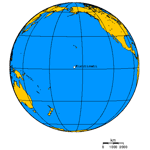
Kiritimati (also known as Christmas Island) is a Pacific Ocean atoll in the northern Line Islands. It is part of the Republic of Kiribati. The name is derived from the English word "Christmas" written in Gilbertese according to its phonology, in which the combination ''ti'' is pronounced ''s'', giving kiˈrɪsmæs. Kiritimati has the greatest land area of any atoll in the world, about ; its lagoon is roughly the same size. The atoll is about in perimeter, while the lagoon shoreline extends for over . Kiritimati comprises over 70% of the total land area of Kiribati, a country encompassing 33 Pacific atolls and islands. It lies north of the equator, south of Honolulu, and from San Francisco. Kiritimati is in the world's farthest forward time zone, UTC+14, and is therefore one of the first inhabited places on Earth to experience New Year's Day. (see also Caroline Atoll, Kiribati). Although it lies east of the 180th meridian, the Republic of Kiribati realigned the Internati ... [...More Info...] [...Related Items...] OR: [Wikipedia] [Google] [Baidu] |
Palmyra Island
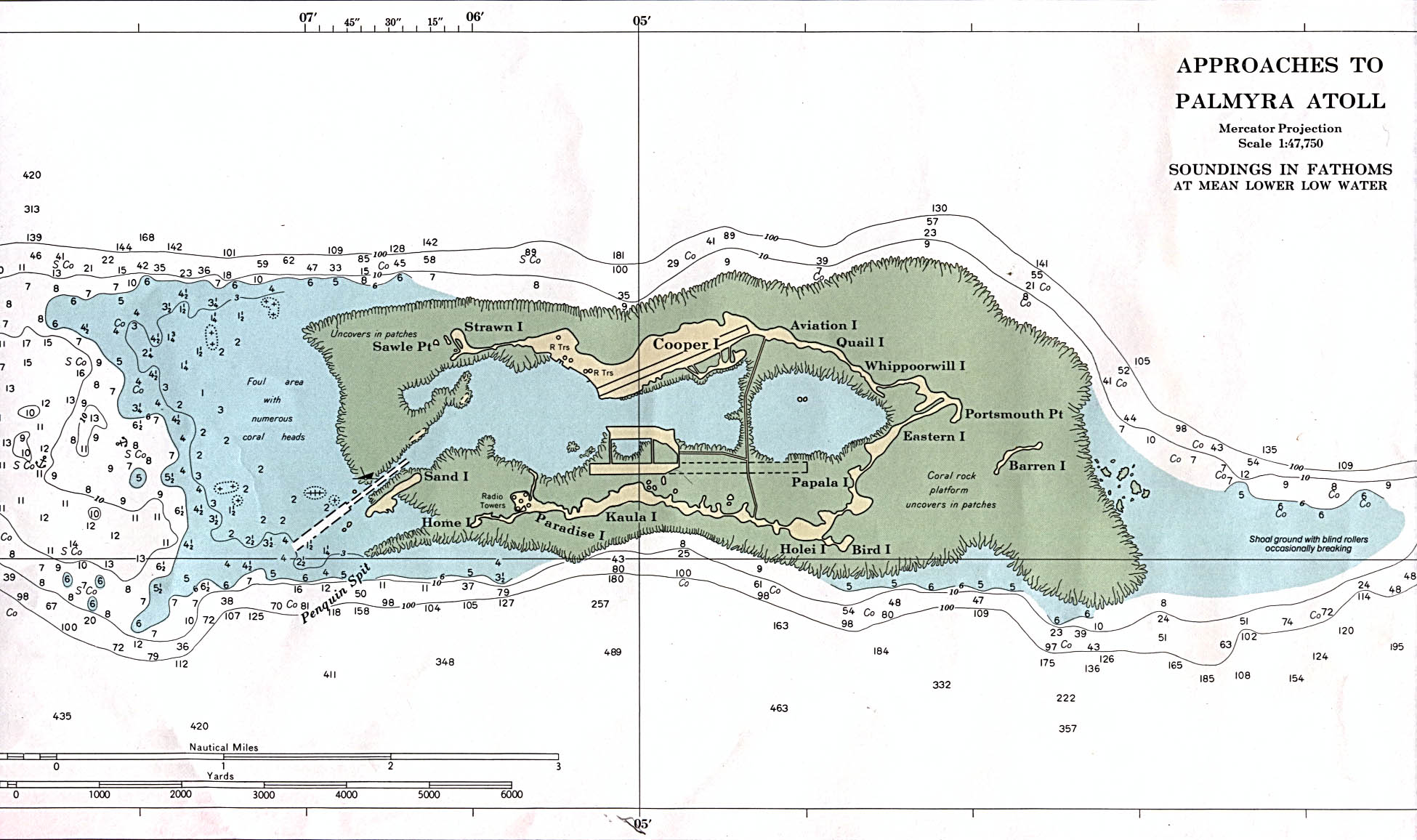
Palmyra Atoll (), also referred to as Palmyra Island, is one of the Northern Line Islands (southeast of Kingman Reef and north of Kiribati). It is located almost due south of the Hawaiian Islands, roughly one-third of the way between Hawaii and American Samoa. North America is about northeast and New Zealand the same distance southwest, placing the atoll at the approximate center of the Pacific Ocean. The land area is , with about 9 miles (14 km) of sea-facing coastline and reef. There is one boat anchorage known as West Lagoon, accessible from the sea by a narrow artificial channel. It is the second-to-northernmost of the Line Islands, and one of three American islands in the archipelago, along with Jarvis Island and Kingman Reef. Palmyra Atoll is part of the Pacific Remote Islands Marine National Monument, the world's largest marine protected area. The atoll is composed of submerged sand flats along with dry land and reefs. It consists of three lagoons separated by cor ... [...More Info...] [...Related Items...] OR: [Wikipedia] [Google] [Baidu] |
Honolulu
Honolulu (; ) is the capital and largest city of the U.S. state of Hawaii, which is in the Pacific Ocean. It is an unincorporated county seat of the consolidated City and County of Honolulu, situated along the southeast coast of the island of Oahu, and is the westernmost and southernmost major U.S. city. Honolulu is Hawaii's main gateway to the world. It is also a major hub for business, finance, hospitality, and military defense in both the state and Oceania. The city is characterized by a mix of various Asian, Western, and Pacific cultures, reflected in its diverse demography, cuisine, and traditions. ''Honolulu'' means "sheltered harbor" or "calm port" in Hawaiian; its old name, ''Kou'', roughly encompasses the area from Nuuanu Avenue to Alakea Street and from Hotel Street to Queen Street, which is the heart of the present downtown district. The city's desirability as a port accounts for its historical growth and importance in the Hawaiian archipelago and the broader P ... [...More Info...] [...Related Items...] OR: [Wikipedia] [Google] [Baidu] |
Polynesia
Polynesia () "many" and νῆσος () "island"), to, Polinisia; mi, Porinihia; haw, Polenekia; fj, Polinisia; sm, Polenisia; rar, Porinetia; ty, Pōrīnetia; tvl, Polenisia; tkl, Polenihia (, ) is a subregion of Oceania, made up of more than 1,000 islands scattered over the central and southern Pacific Ocean. The indigenous people who inhabit the islands of Polynesia are called Polynesians. They have many things in common, including language relatedness, cultural practices, and traditional beliefs. In centuries past, they had a strong shared tradition of sailing and using stars to navigate at night. The largest country in Polynesia is New Zealand. The term was first used in 1756 by the French writer Charles de Brosses, who originally applied it to all the islands of the Pacific. In 1831, Jules Dumont d'Urville proposed a narrower definition during a lecture at the Geographical Society of Paris. By tradition, the islands located in the southern Pacific have also ... [...More Info...] [...Related Items...] OR: [Wikipedia] [Google] [Baidu] |
Hawaiian Islands
The Hawaiian Islands ( haw, Nā Mokupuni o Hawai‘i) are an archipelago of eight major islands, several atolls, and numerous smaller islets in the North Pacific Ocean, extending some from the island of Hawaii in the south to northernmost Kure Atoll. Formerly the group was known to Europeans and Americans as the Sandwich Islands, a name that James Cook chose in honor of the 4th Earl of Sandwich, the then First Lord of the Admiralty. Cook came across the islands by chance when crossing the Pacific Ocean on his Third Voyage in 1778, on board HMS ''Resolution''; he was later killed on the islands on a return visit. The contemporary name of the islands, dating from the 1840s, is derived from the name of the largest island, Hawaii Island. Hawaii sits on the Pacific Plate and is the only U.S. state that is not geographically connected to North America. It is part of the Polynesia subregion of Oceania. The state of Hawaii occupies the archipelago almost in its entirety (includin ... [...More Info...] [...Related Items...] OR: [Wikipedia] [Google] [Baidu] |
Miscellaneous Auxiliary
The United States Navy, United States Coast Guard, and United States National Oceanic and Atmospheric Administration (NOAA) use a hull classification symbol (sometimes called hull code or hull number) to identify their ships by type and by individual ship within a type. The system is analogous to the pennant number system that the Royal Navy and other European and Commonwealth navies use. History United States Navy The U.S. Navy began to assign unique Naval Registry Identification Numbers to its ships in the 1890s. The system was a simple one in which each ship received a number which was appended to its ship type, fully spelled out, and added parenthetically after the ship's name when deemed necessary to avoid confusion between ships. Under this system, for example, the battleship ''Indiana'' was USS ''Indiana'' (Battleship No. 1), the cruiser ''Olympia'' was USS ''Olympia'' (Cruiser No. 6), and so on. Beginning in 1907, some ships also were referred to alternative ... [...More Info...] [...Related Items...] OR: [Wikipedia] [Google] [Baidu] |
Honolulu, Hawaii
Honolulu (; ) is the capital and largest city of the U.S. state of Hawaii, which is in the Pacific Ocean. It is an unincorporated county seat of the consolidated City and County of Honolulu, situated along the southeast coast of the island of Oahu, and is the westernmost and southernmost major U.S. city. Honolulu is Hawaii's main gateway to the world. It is also a major hub for business, finance, hospitality, and military defense in both the state and Oceania. The city is characterized by a mix of various Asian, Western, and Pacific cultures, reflected in its diverse demography, cuisine, and traditions. ''Honolulu'' means "sheltered harbor" or "calm port" in Hawaiian; its old name, ''Kou'', roughly encompasses the area from Nuuanu Avenue to Alakea Street and from Hotel Street to Queen Street, which is the heart of the present downtown district. The city's desirability as a port accounts for its historical growth and importance in the Hawaiian archipelago and the broader Pa ... [...More Info...] [...Related Items...] OR: [Wikipedia] [Google] [Baidu] |

_underway_off_Tulagi%2C_circa_7_August_1942.jpg)


