|
Taoyuan–Zhongli Metropolitan Area
Taoyuan–Zhongli metropolitan area () is the metropolitan area located in northwestern Taiwan, which encompasses most of Taoyuan City as well as parts of neighbouring urban districts of New Taipei such as Yingge and Linkou, with a total population of 2,309,475 as of mid of 2019. The districts of Taoyuan and Zhongli are typical twin cities within the region which share approximate population sizes and similar function of urban centres, and have been respectively emerging to regional commercial centres on the periphery of the northern and southern parts of the municipality. Many industrial parks and tech company headquarters settle in this region. Taoyuan City witnessed the fastest population growth of Taiwan in the past few decades, and since 2014 it has been promoted to a special municipality from county status. It has become the fourth largest metropolitan area in Taiwan. In some sources, Taoyuan–Zhongli metropolitan area is occasionally viewed as an extent of Taipei met ... [...More Info...] [...Related Items...] OR: [Wikipedia] [Google] [Baidu] |
Taoyuan Metropolitan
Taoyuan may refer to: Mainland China * Taoyuan County (桃源县), county of Changde, Hunan * Taoyuan Subdistrict (other) ;Towns Written as "桃園镇": * Taoyuan, Rugao, Jiangsu * Taoyuan, Xuzhou, in Suining County, Jiangsu * Taoyuan, Feicheng, Shandong Written as "桃源镇": * Taoyuan, Fujian, in Datian County * Taoyuan, Dabu County, Guangdong * Taoyuan, Jiangmen, in Heshan, Guangdong * Taoyuan, Suzhou, in Wujiang, Jiangsu Taiwan * Taoyuan, Taiwan (桃園市), special municipality, formerly known as Taoyuan County (桃園縣) * Taoyuan District (桃園區), urban district of Taoyuan City, formerly itself known as Taoyuan City * Taoyuan District, Kaohsiung (桃源區), rural district of Kaohsiung City * Taoyuan International Airport , the main international airport in Taiwan See also * Taoyuan Air Base, a former Republic of China Air Force base * Tao Yuan (other) * Taiyuan Taiyuan (; ; ; Mandarin pronunciation: ; also known as (), ()) is ... [...More Info...] [...Related Items...] OR: [Wikipedia] [Google] [Baidu] |
Government Of The Republic Of China
The Government of the Republic of China, is the national government of the Republic of China whose ''de facto'' territory currently consists of Taiwan, Penghu, Kinmen, Matsu and other island groups in the "free area". Governed by the Democratic Progressive Party, the president is the head of state. The government consists of the presidency and five branches (Yuan): the Executive Yuan, Legislative Yuan, Judicial Yuan, Examination Yuan, and Control Yuan. Originally established in 1912 in Nanking, the Government of the Republic of China relocated several times before finally moving to Taipei, Taiwan in 1949 because of its military losses in the Chinese Civil War. The government has historically been dominated by the Kuomintang under the Dang Guo authoritarian regime, but the situation has changed as Taiwan evolved into a multi-party democracy. Organizational structure The government formally consists of the presidency and five branches of government, modeled on Sun Yat ... [...More Info...] [...Related Items...] OR: [Wikipedia] [Google] [Baidu] |
Xinwu District, Taoyuan
Xinwu or Sinwu District is a rural, coastal district in Taoyuan City, Taiwan, home to 49,046 people, of which most are Hakka. Geography * Area: * Population: 49,046 (May 2022) Xinwu District accounts for almost 7% of Taoyuan's total land area and is the city's 6th largest district. Local industries include agriculture, fisheries, and livestock. 88% of Xinwu residents are Hakka. Many rivers flow through the district, including the Shezih, Sinwu, Foshing, Fusing and Houhu. Administrative divisions * Xinwu * Xinsheng * Houhu * Qinghua * Shilei * Tungming * Shezi * Puding * Jiudou * Touzhou * Dapo * Wangjian * Houzhuang * Kejian * Shenzun * Kanglang * Bengang * Yongan * Yongxing * Xiapu * Shipai * Xiatian * Chilan Village Education Xinwu has eleven elementary schools, four junior high schools, and two high schools. It also has one district nursery, three kindergartens, other private kindergartens, and a district library. Tourist attractions Farms, Gardens and Parks * Changsh ... [...More Info...] [...Related Items...] OR: [Wikipedia] [Google] [Baidu] |
Yangmei District
Yangmei District () is a District (Taiwan), district in southwestern Taoyuan City, Taiwan. The centre of the district is Yangmei town itself. The traditional residents are Hakka people. History Yangmei town was originally established as ''Yangmeili'' () during Taiwan under Qing rule, Qing dynasty rule. The name was shortened in 1920, during Taiwan under Japanese rule, Japanese rule. Under the Republic of China, the former Township (Taiwan), township was upgraded to a county-administered city after passing 150,000 in population. On 25 December 2014, it was upgraded again to a District (Taiwan), district. Geography Yangmei is the third largest district in Taoyuan City. The center is only 40 minutes from the west coast of Taiwan and the Taiwan Strait. To the north it borders Pingzhen District; to the south it borders Hsinchu County. To the east, Yangmei borders Longtan District, Taoyuan, Longtan District. The district owes its name from the abundance of ''Myrica rubra'' (yangmei t ... [...More Info...] [...Related Items...] OR: [Wikipedia] [Google] [Baidu] |
Pingzhen District
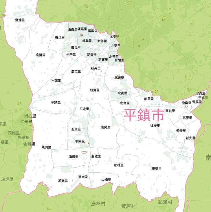
Pingzhen District () is a district in the central part of Taoyuan City, Taiwan, home to 227,047 people. History Pingzhen was originally established as Changluliao during the Qing Dynasty rule of Taiwan. In 1920 under the Japanese rule, the city was renamed to Pingzhen. On 1 March 1992, it was upgraded from a rural township as the third county-administered city of Taoyuan County named Pingzhen City. On 25 December 2014, it was upgraded to a district named Pingzhen District when Taoyuan County was upgraded from a county to a municipality. Geography The district spans over 47.75km2 of area. It is located on a hilly plateau and the entire district is on a slope. Demographics Pingzhen District has a population of 227,047 people as of May 2022. Most people in Pingzhen are Hakka. Administrative divisions Pingzeng, Zengxing, Nanshi, Jinxing, Pingan, Pingnan, Shanfeng, Fulin, Yongguang, Zhuangjing, Yongfeng, Yongan, Songwu, Pingxing, Guangxing, Guangda, Guangren, Fudan, Fuxing, Yim ... [...More Info...] [...Related Items...] OR: [Wikipedia] [Google] [Baidu] |
Longtan District, Taoyuan
Longtan District () is a rural District (Taiwan), district in southern Taoyuan City, Taiwan. Longtan is home to the headquarters of the Republic of China Army. The township is known for the Buddhist temple in the center of Longtan Lake and the large Bainien community project. The area is surrounded by high-tech industries and mountains. Longtan is home to a number of military bases, and a few research installations. National Chung-Shan Institute of Science and Technology and Institute of Nuclear Energy Research . are two of the more well known ones. History Longtan used to be a Township (Taiwan), rural township of the former Taoyuan City, Taoyuan County. On 25 Decem ...[...More Info...] [...Related Items...] OR: [Wikipedia] [Google] [Baidu] |
Guanyin District
Guanyin District () is a rural, coastal district in western Taoyuan City, Taiwan. Guanyin is the name of a Buddhist goddess. History Guanyin was originally named as Shiguanyin during the Qing Dynasty rule. It was renamed to Guanyin in 1920 during the Japanese rule. After the handover of Taiwan from Japan to the Republic of China in 1945, Guanyin was reestablished as a township of Taoyuan County. On 25 December 2014, it was upgraded to a district named Guanyin District of Taoyuan City. Geography * Area: 87.98 km2 * Population: 64,845 people (January 2016) Guanyin is part of the alluvial fan in Taoyuan City. The coastline is about 15 km at the northern side. Administrative divisions Guanyin, Baiyu, Guangxing, Datan, Baosheng, Wuwei, Sanhe, Xinxing, Kengwei, Jinhu, Lanpu, Datong, Daku, Lunping, Fuyuan, Shangda, Xinpo, Guangfu, Tajiao, Baozhang, Caota, Caoxin, Shulin and Fulin Village. Infrastructure * Tatan Power Plant Tourist attractions * Baishajia Lighthouse * ... [...More Info...] [...Related Items...] OR: [Wikipedia] [Google] [Baidu] |
Dayuan District
Dayuan District (), formerly known as Dayuan Township () is a coastal district in northwestern Taoyuan City, Taiwan. History Dayuan District was originally named ''Toa-khu-hng'' (), literally means a vast (大) vegetable garden (坵園) as an old Chinese name). In the earlier days, cottage scattered around the district with very limited settlers that grows vegetable and sweet potatoes. Hoklo people migrated to the area during the rule of Kangxi. In avoidance of the invasion of Yue people, walled villages were built around the settlements of Hoklo people. It was renamed during Japanese rule, and was part of Tōen District, Shinchiku Prefecture. After the handover of Taiwan from Japan to the Republic of China, it was called Dayuan Township. It became Dayuan District in 2014, when Taoyuan County became a special municipality (and the former city of Taoyuan became a district of the special municipality). Geography Demographics The population in 1986 was 56,995. By the end o ... [...More Info...] [...Related Items...] OR: [Wikipedia] [Google] [Baidu] |
Luzhu District, Taoyuan
Luzhu District () is a district in Taoyuan City, Taiwan, home to 165,914 people. The downtown district, known as Nankan, is now a high density, high-rise suburb for many who work in Taipei and Taoyuan City. The first opened shopping center in Taiwan, Taimall, located in Nankan, is a weekend destination for many Taoyuan regional residents. Taimall is located around north-northwest of the Nankan interchange, , on National Freeway 1. History Luzhu was upgraded to a county-administered city from the former rural township of Taoyuan County on 3 June 2014. On 25 December 2014, it was upgraded again to a district named Luzhu District of Taoyuan City. Geography * Area: * Population: 155,626 (January 2016) Administrative divisions The district is administered as 37 villages: Dazhu, Fuchang, Fulu, Fuxing, Fuzhu, Haihu, Hongzhu, Jinxing, Jinzhong, Jixiang, Kengkou, Kengzi, Luxing, Luzhu, Nankan, Nanrong, Nanxing, Neicuo, Shanbi, Shangxing, Shangzhu, Shanjiao, Shunxing, ... [...More Info...] [...Related Items...] OR: [Wikipedia] [Google] [Baidu] |
Guishan District
Guishan District () is a district in northeastern Taoyuan City, Taiwan. History Guishan was formerly known as ''Kulunsia'' ( (Ku-lun-siā))). The name originated from a hill by the Mercy Buddha Temple of Shou Shan Rock, built in 7th year of the Qianlong Period of the Qing Dynasty. The plains aborigines and Ketagalan tribes were located here. From 1920 to 1945, was under Tōen District, Shinchiku Prefecture. In 1950, it was renamed to ''Kueishan''. On 25 December 2014, it was upgraded from Guishan Township to a district called Guishan District. Geography * Area: 75.50km2 * Population: 168,200 people (May 2022) Administrative divisions Ching-chung, Liou-kuang, Chung-hsing, Hsin-hsing, Hsin-lu, Kuei-shan, Ta-tung, Shan-ting, Shan-teh, Shan-fu, Hsing-fu, Lung-shou, Lung-hwa, Huei-lung, Ling-ting, Hsin-ling, Tu-keng, Fu-yuan, Chiou-lu, Ta-keng, Fung-shu, Leh-shan, Chang-keng, Kung-hsi, Ta-kang, Ta-hu, Ta-hwa, Wuen-hua, Nan-shang and Nan-mei Village. Government and infrastructur ... [...More Info...] [...Related Items...] OR: [Wikipedia] [Google] [Baidu] |
Daxi District
Daxi District (), formerly known as Daxi Township (), is a district in eastern Taoyuan City, Taiwan. In March 2012, it was named one of the ''Top 10 Small Tourist Towns'' by the Tourism Bureau of Taiwan. History The Daxi area was occupied for several thousand years by the Atayal people. The Atayal called the local river (modern-day Dahan Creek) ''Takoham'' in their native Austronesian language. This gave rise to similar names such as ''Toa-kho-ham'' (; also ) in Hokkien and ''Taikokan'' in Japanese via transliteration. Eighteenth-century Han settlement in the Taipei Basin led many Atayal families to relocate upriver, though some Atayal stayed and mingled with the newcomers. The settlement later became an important trading post in the 19th century. In 1803, open fighting broke out between two rival factions of Han settlers in Taipei, and many refugees fled south for safety. Among the refugees was the Lin Ben Yuan Family, one of the wealthiest clans in Taiwan at the time. ... [...More Info...] [...Related Items...] OR: [Wikipedia] [Google] [Baidu] |
Bade District
Bade District () is a district in the central part of Taoyuan City, Taiwan (Republic of China.) It is the smallest district by area in Taoyuan City. History Bade City was originally established as Bakuaicuo (八塊厝) during Qing Dynasty rule. During the period of Japanese rule, it was called ''Hachitoku Village'' (八塊庄), and was governed under Tōen District (桃園郡) of Shinchiku Prefecture. After the handover of Taiwan from Japan to the Republic of China, the area was established as a rural township and named Bade Township in 1946. In 1995, it was upgraded as a county-administered city named Bade City (). On 25 December 2014, it became Bade District. Geography Area: Population: 209,148 (August 2022) Administrative divisions The district comprises 48 villages: Bailu, Daai, Daan, Dachang, Dacheng, Dafa, Dafu, Dahan, Dahe, Dahong, Dahua, Dajiang, Daming, Danan, Daqian, Daqing, Daren, Darong, Dashun, Datong, Daxin, Daxing, Dayi, Dayong, Dazheng, Dazhi, Dazhong, D ... [...More Info...] [...Related Items...] OR: [Wikipedia] [Google] [Baidu] |


