|
Tader Valles
The Tader Valles are a set of small channels in the Phaethontis quadrangle found at 49.1° south latitude and 152.5° west longitude. They are named after the ancient name for present Segura River, Spain. Ice-rich mantle Much of the surface of Mars is covered by a thick smooth mantle that is thought to be a mixture of ice and dust. This ice-rich mantle, a few yards thick, smooths the land, but in places it has a bumpy texture, resembling the surface of a basketball. Under certain conditions the ice could melt and flow down the slopes to create gullies. Because there are few craters on this mantle, the mantle is relatively young. This mantle probably fills the Tader Valles as shown in the HiRISE image below. Changes in Mars's orbit and tilt cause significant changes in the distribution of water ice from polar regions down to latitudes equivalent to Texas. During certain climate periods water vapor leaves polar ice and enters the atmosphere. The water comes back to ground ... [...More Info...] [...Related Items...] OR: [Wikipedia] [Google] [Baidu] |
Volcanoes
A volcano is a rupture in the crust of a planetary-mass object, such as Earth, that allows hot lava, volcanic ash, and gases to escape from a magma chamber below the surface. On Earth, volcanoes are most often found where tectonic plates are diverging or converging, and most are found underwater. For example, a mid-ocean ridge, such as the Mid-Atlantic Ridge, has volcanoes caused by divergent tectonic plates whereas the Pacific Ring of Fire has volcanoes caused by convergent tectonic plates. Volcanoes can also form where there is stretching and thinning of the crust's plates, such as in the East African Rift and the Wells Gray-Clearwater volcanic field and Rio Grande rift in North America. Volcanism away from plate boundaries has been postulated to arise from upwelling diapirs from the core–mantle boundary, deep in the Earth. This results in hotspot volcanism, of which the Hawaiian hotspot is an example. Volcanoes are usually not created where two tectonic plates slide pa ... [...More Info...] [...Related Items...] OR: [Wikipedia] [Google] [Baidu] |
Segura River
Segura (, ; la, Thader; ar, شقورة, Shaqūrah, or ) is a medium-sized river in southeastern Spain. It has its source in the Sierra de Segura. Course The river begins at Santiago Pontones ( province of Jaén), passes Calasparra, Cieza, Blanca, Murcia, Beniaján (Region of Murcia), , Orihuela, Rojales and flows into the Mediterranean Sea near Guardamar del Segura in the province of Alicante. Some of its tributaries are the Mundo (which starts near Riópar), the Alhárabe (which starts in Moratalla), the Mula and the Guadalentín. The alluvial plain is called the ''Vega del Segura'' and is a very productive agricultural region growing a wide variety of fruit, vegetables and flowers. The ''Vegas'' are divided into three areas: ''Alta'', ''Media'' and ''Baja'' (upper, medium, and lower). Affluents The Segura's main tributaries or affluents are: Right bank: * Zumeta * River Taibilla, 2,95 m³/s * River Alhárabe, 0,20 m³/s ** Río Benamor * Río Argos, 0,5 ... [...More Info...] [...Related Items...] OR: [Wikipedia] [Google] [Baidu] |
Spain
, image_flag = Bandera de España.svg , image_coat = Escudo de España (mazonado).svg , national_motto = ''Plus ultra'' (Latin)(English: "Further Beyond") , national_anthem = (English: "Royal March") , image_map = , map_caption = , image_map2 = , capital = Madrid , coordinates = , largest_city = Madrid , languages_type = Official language , languages = Spanish language, Spanish , ethnic_groups = , ethnic_groups_year = , ethnic_groups_ref = , religion = , religion_ref = , religion_year = 2020 , demonym = , government_type = Unitary state, Unitary Parliamentary system, parliamentary constitutional monarchy , leader_title1 = Monarchy of Spain, Monarch , leader_name1 = Felipe VI , leader_title2 = Prime Minister of Spain ... [...More Info...] [...Related Items...] OR: [Wikipedia] [Google] [Baidu] |
Phaethontis Quadrangle
The Phaethontis quadrangle is one of a series of 30 quadrangle maps of Mars used by the United States Geological Survey (USGS) Astrogeology Research Program. The Phaethontis quadrangle is also referred to as MC-24 (Mars Chart-24). The name comes from Phaethon, the son of Helios. The Phaethontis quadrangle lies between 30° and 65 ° south latitude and 120° and 180 ° west longitude on Mars. This latitude range is where numerous gullies have been discovered. An old feature in this area, called Terra Sirenum lies in this quadrangle; Mars Reconnaissance Orbiter discovered iron/magnesium smectites there. Part of this quadrangle contains what is called the Electris deposits, a deposit that is thick. It is light-toned and appears to be weak because of few boulders. Among a group of large craters is Mariner Crater, first observed by the Mariner IV spacecraft in the summer of 1965. It was named after that spacecraft. A low area in Terra Sirenum is believed to have once held a ... [...More Info...] [...Related Items...] OR: [Wikipedia] [Google] [Baidu] |
THEMIS
In Greek mythology and Ancient Greek religion, religion, Themis (; grc, Θέμις, Themis, justice, law, custom) is one of the twelve Titans, Titan children of Gaia and Uranus (mythology), Uranus, and the second wife of Zeus. She is the goddess and personification of justice, divine order, fairness, law, and custom, and her symbols include the Scales of Justice (symbol), Scales of Justice. She is also associated with oracles and prophecies, including the Pythia, Oracle of Delphi. Name ''Themis'' means "divine law" rather than human ordinance, literally "that which is put in place", from the Greek verb ''títhēmi'' (wikt:τίθημι, τίθημι), meaning "to put." To the ancient Greeks she was originally the organizer of the "communal affairs of humans, particularly assemblies." Moses Finley remarked of ''themis'', as the word was used by Homer in the 8th century BCE, to evoke the social order of the 10th- and 9th-century Greek Dark Ages: Finley adds, "There was ''them ... [...More Info...] [...Related Items...] OR: [Wikipedia] [Google] [Baidu] |
Climate Of Mars
The climate of Mars has been a topic of scientific curiosity for centuries, in part because it is the only terrestrial planet whose surface can be directly observed in detail from the Earth with help from a telescope. Although Mars is smaller than the Earth, 11% of Earth's mass, and 50% farther from the Sun than the Earth, its climate has important similarities, such as the presence of polar ice caps, seasonal changes and observable weather patterns. It has attracted sustained study from planetologists and climatologists. While Mars' climate has similarities to Earth's, including periodic ice ages, there are also important differences, such as much lower thermal inertia. Mars' atmosphere has a scale height of approximately , 60% greater than that on Earth. The climate is of considerable relevance to the question of whether life is or ever has been present on the planet. The climate briefly received more interest in the news due to NASA measurements indicating increased sublima ... [...More Info...] [...Related Items...] OR: [Wikipedia] [Google] [Baidu] |
Geology Of Mars
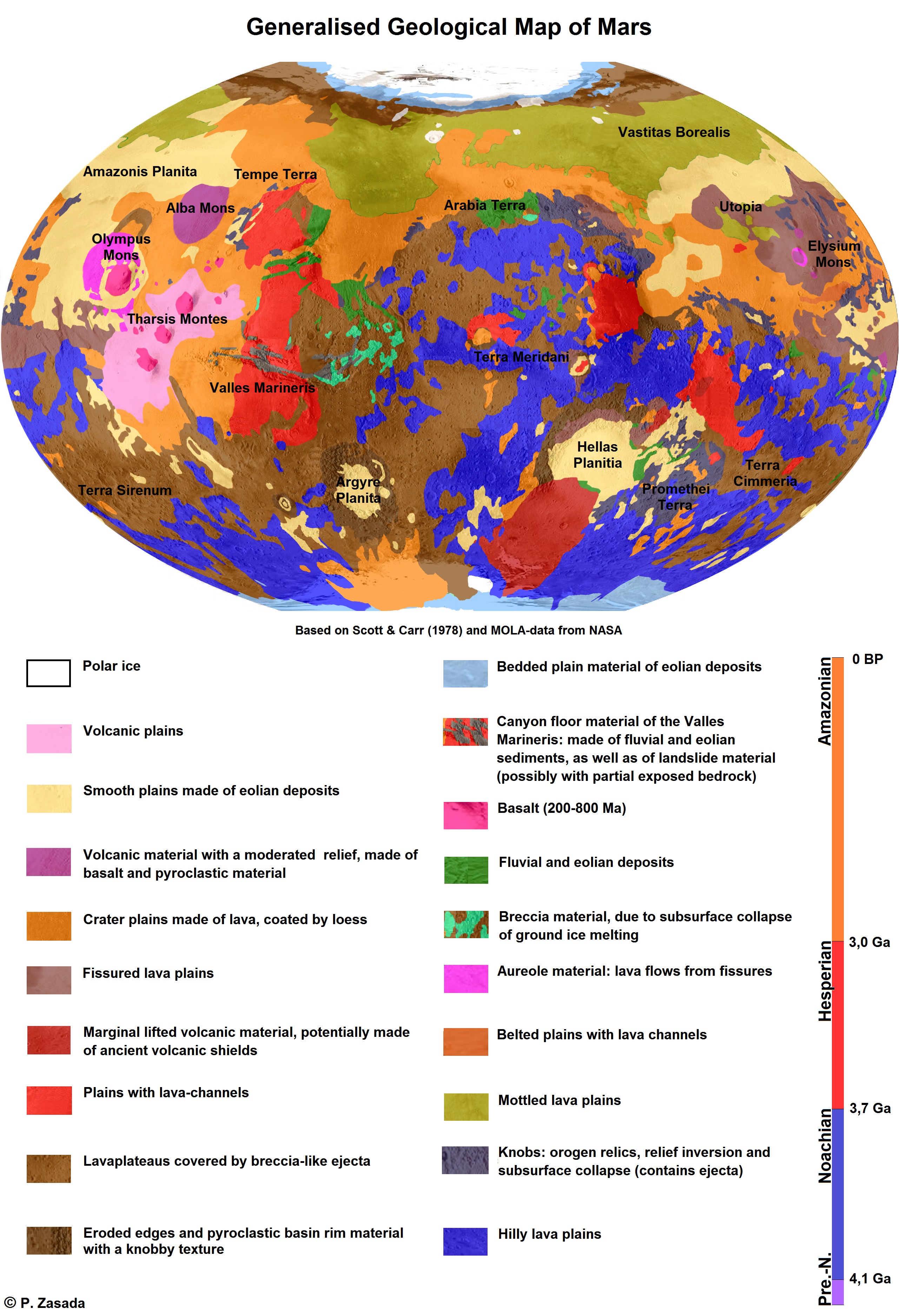
The geology of Mars is the scientific study of the surface, crust, and interior of the planet Mars. It emphasizes the composition, structure, history, and physical processes that shape the planet. It is analogous to the field of terrestrial geology. In planetary science, the term ''geology'' is used in its broadest sense to mean the study of the solid parts of planets and moons. The term incorporates aspects of geophysics, geochemistry, mineralogy, geodesy, and cartography. A neologism, areology, from the Greek word ''Arēs'' (Mars), sometimes appears as a synonym for Mars's geology in the popular media and works of science fiction (e.g. Kim Stanley Robinson, Kim Stanley Robinson's Mars trilogy). The term areology is also used by the Areological Society. Geological map of Mars (2014) File:Geologic Map of Mars figure2.pdf, Figure 2 for the geologic map of Mars Global Martian topography and large-scale features Composition of Mars Mars is a terrestrial planet, whic ... [...More Info...] [...Related Items...] OR: [Wikipedia] [Google] [Baidu] |
Latitude Dependent Mantle
Much of the Martian surface is covered with a thick ice-rich, mantle layer that has fallen from the sky a number of times in the past. In some places a number of layers are visible in the mantle. Image:Layered mantle in Icaria Planum.JPG, Layers in mantle deposit, as seen by HiRISE, under the HiWish program. Mantle was probably formed from snow and dust falling during a different climate. Location is Thaumasia quadrangle ESP 039721 1400mantlelayers.jpg, HiRISE image showing smooth mantle covering parts of a crater in the Phaethontis quadrangle. Along the outer rim of the crater, the mantle is displayed as layers. This suggests that the mantle was deposited multiple times in the past. Picture was taken with HiRISE under HiWish program. The layers are enlarged in the next image. ESP 039721 1400mantlelayersclose.jpg, Enlargement of previous image of mantle layers. Four to five layers are visible. Location is the Phaethontis quadrangle. Esp 037167 1445mantle.jpg, Surface s ... [...More Info...] [...Related Items...] OR: [Wikipedia] [Google] [Baidu] |
Planetary Nomenclature
Planetary nomenclature, like terrestrial nomenclature, is a system of uniquely identifying features on the surface of a planet or natural satellite so that the features can be easily located, described, and discussed. Since the invention of the telescope, astronomers have given names to the surface features they have discerned, especially on the Moon and Mars. To found an authority on planetary nomenclature, the International Astronomical Union (IAU) was organized in 1919 to designate and standardize names for features on Solar System bodies. How names are approved by the IAU When images are first obtained of the surface of a planet or satellite, a theme for naming features is chosen and a few important features are named, usually by members of the appropriate IAU task group (a commonly accepted planet-naming group). Later, as higher resolution images and maps become available, additional features are named at the request of investigators mapping or describing specific surfaces, ... [...More Info...] [...Related Items...] OR: [Wikipedia] [Google] [Baidu] |


