|
Latitude Dependent Mantle
Much of the Martian surface is covered with a thick ice-rich, mantle layer that has fallen from the sky a number of times in the past. In some places a number of layers are visible in the mantle. Image:Layered mantle in Icaria Planum.JPG, Layers in mantle deposit, as seen by HiRISE, under the HiWish program. Mantle was probably formed from snow and dust falling during a different climate. Location is Thaumasia quadrangle ESP 039721 1400mantlelayers.jpg, HiRISE image showing smooth mantle covering parts of a crater in the Phaethontis quadrangle. Along the outer rim of the crater, the mantle is displayed as layers. This suggests that the mantle was deposited multiple times in the past. Picture was taken with HiRISE under HiWish program. The layers are enlarged in the next image. ESP 039721 1400mantlelayersclose.jpg, Enlargement of previous image of mantle layers. Four to five layers are visible. Location is the Phaethontis quadrangle. Esp 037167 1445mantle.jpg, Surface s ... [...More Info...] [...Related Items...] OR: [Wikipedia] [Google] [Baidu] |
HiWish Program
HiWish is a program created by NASA so that anyone can suggest a place for the HiRISE camera on the Mars Reconnaissance Orbiter to photograph. It was started in January 2010. In the first few months of the program 3000 people signed up to use HiRISE. The first images were released in April 2010. Over 12,000 suggestions were made by the public; suggestions were made for targets in each of the 30 quadrangles of Mars. Selected images released were used for three talks at the 16th Annual International Mars Society Convention. Below are some of the over 4,224 images that have been released from the HiWish program as of March 2016. Glacial features Some landscapes look just like glaciers moving out of mountain valleys on Earth. Some have a hollowed-out appearance, looking like a glacier after almost all the ice has disappeared. What is left are the moraines—the dirt and debris carried by the glacier. The center is hollowed out because the ice is mostly gone. These supposed alp ... [...More Info...] [...Related Items...] OR: [Wikipedia] [Google] [Baidu] |
Thaumasia Quadrangle
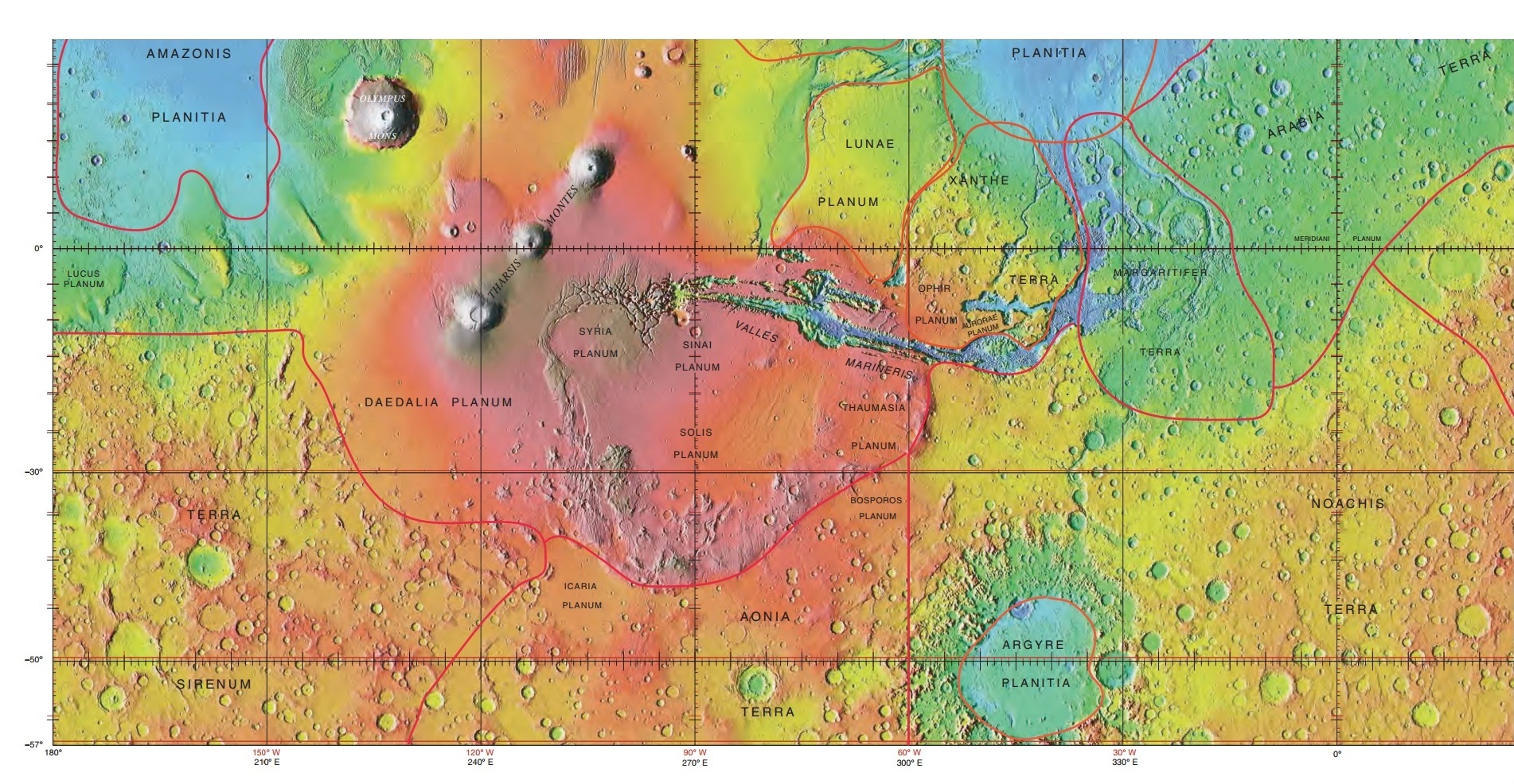
The Thaumasia quadrangle is one of a series of 30 quadrangle maps of Mars used by the United States Geological Survey (USGS) Astrogeology Research Program. The Thaumasia quadrangle is also referred to as MC-25 (Mars Chart-25). The name comes from Thaumas, the god of the clouds and celestial apparitions. The Thaumasia quadrangle covers the area from 60° to 120° west longitude and 30° to 65° south latitude on Mars. The Thaumasia quadrangle contains many different regions or parts of many regions: Solis Planum, Icaria Planum, Aonia Terra, Aonia Planum, Bosporus Planum, and Thaumasia Planum. One of the first major networks of stream channels, called Warrego Valles, were discovered here by early orbiters. Another sign of water is the presence of gullies carved into steep slopes. Martian Gullies Gullies are common in some parts of Mars. Gullies occur on steep slopes, especially on the walls of craters. Martian gullies are believed to be relatively young because they have few, ... [...More Info...] [...Related Items...] OR: [Wikipedia] [Google] [Baidu] |
Phaethontis Quadrangle
The Phaethontis quadrangle is one of a series of 30 quadrangle maps of Mars used by the United States Geological Survey (USGS) Astrogeology Research Program. The Phaethontis quadrangle is also referred to as MC-24 (Mars Chart-24). The name comes from Phaethon, the son of Helios. The Phaethontis quadrangle lies between 30° and 65 ° south latitude and 120° and 180 ° west longitude on Mars. This latitude range is where numerous gullies have been discovered. An old feature in this area, called Terra Sirenum lies in this quadrangle; Mars Reconnaissance Orbiter discovered iron/magnesium smectites there. Part of this quadrangle contains what is called the Electris deposits, a deposit that is thick. It is light-toned and appears to be weak because of few boulders. Among a group of large craters is Mariner Crater, first observed by the Mariner IV spacecraft in the summer of 1965. It was named after that spacecraft. A low area in Terra Sirenum is believed to have once held a ... [...More Info...] [...Related Items...] OR: [Wikipedia] [Google] [Baidu] |
Terra Sirenum
Terra Sirenum is a large region in the southern hemisphere of the planet Mars. It is centered at and covers 3900 km at its broadest extent. It covers latitudes 10 to 70 South and longitudes 110 to 180 W. Terra Sirenum is an upland area notable for massive cratering including the large Newton Crater. Terra Sirenum is in the Phaethontis quadrangle and the Memnonia quadrangle of Mars. A low area in Terra Sirenum is believed to have once held a lake that eventually drained through Ma'adim Vallis. Terra Sirenum is named after the Sirens, who were birds with the heads of girls. In the ''Odyssey'' these girls captured passing seamen and killed them. Chloride deposits Evidence of deposits of chloride based minerals in Terra Sirenum was discovered by the 2001 Mars Odyssey orbiter's Thermal Emission Imaging System in March 2008. The deposits are approximately 3.5 to 3.9 billion years old. This suggests that near-surface water was widespread in early Martian history, which ha ... [...More Info...] [...Related Items...] OR: [Wikipedia] [Google] [Baidu] |
Eridania Quadrangle
The Eridania quadrangle is one of a series of 30 quadrangle maps of Mars used by the United States Geological Survey (USGS) Astrogeology Research Program. The Eridania quadrangle is also referred to as MC-29 (Mars Chart-29). The Eridania quadrangle lies between 30° and 65° south latitude and 180° and 240° west longitude on the planet Mars. Most of the classic region named Terra Cimmeria is found within this quadrangle. Part of the Electris deposits, a 100–200 meters thick, light-toned deposit covers the Eridania quadrangle. Many slopes in Eridania contain gullies, which are believed to be caused by flowing water. Martian Gullies The Eridania quadrangle is the location of gullies that may be due to recent flowing water. Gullies occur on steep slopes, especially on the walls of craters. Gullies are believed to be relatively young because they have few, if any craters. Moreover, they lie on top of sand dunes which themselves are considered to be quite young. Usually, ea ... [...More Info...] [...Related Items...] OR: [Wikipedia] [Google] [Baidu] |
Cebrenia Quadrangle
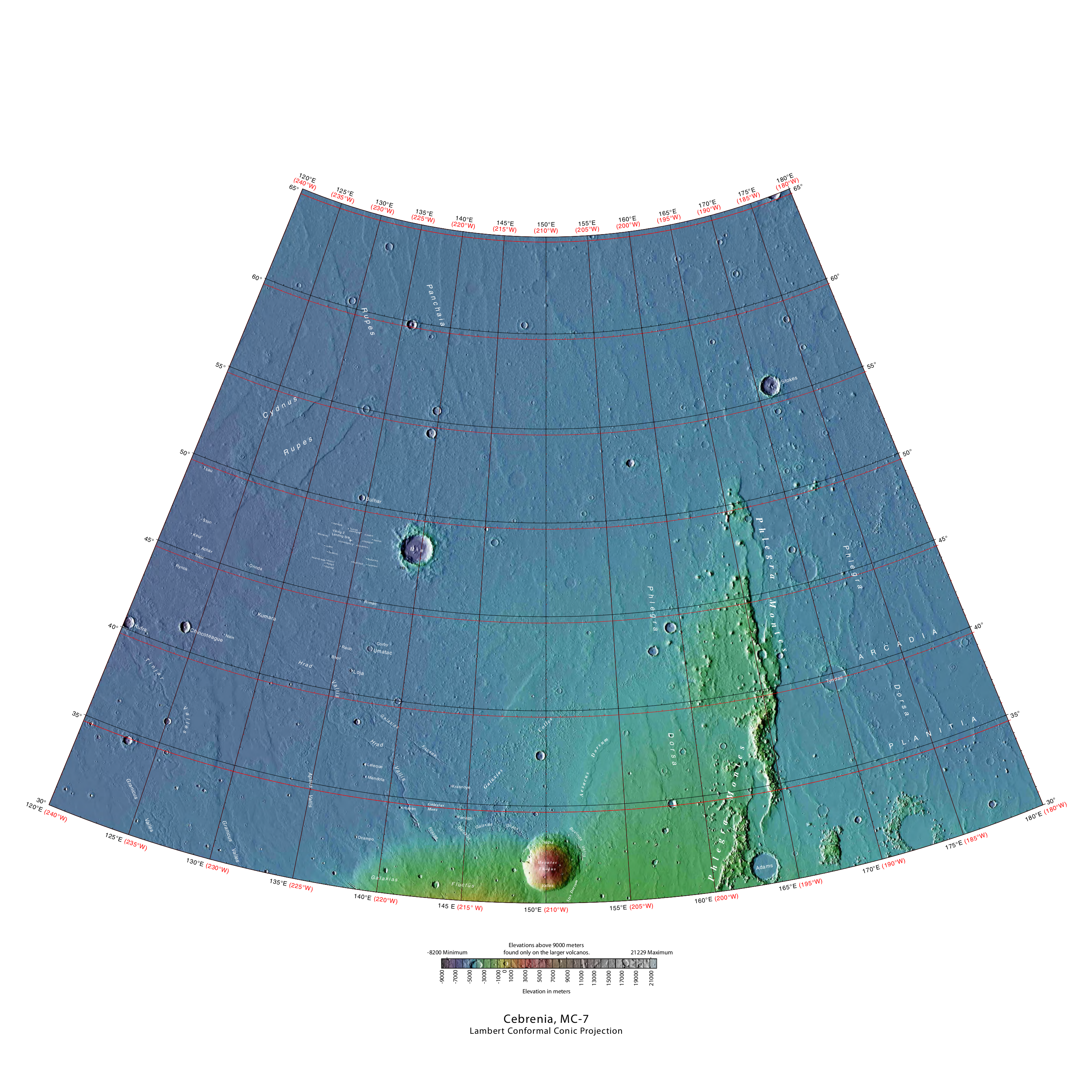
The Cebrenia quadrangle is one of a series of 30 quadrangle maps of Mars used by the United States Geological Survey (USGS) Astrogeology Research Program. The quadrangle is located in the northeastern portion of Mars’ eastern hemisphere and covers 120° to 180° east longitude (180° to 240° west longitude) and 30° to 65° north latitude. The quadrangle uses a Lambert conformal conic projection at a nominal scale of 1:5,000,000 (1:5M). The Cebrenia quadrangle is also referred to as MC-7 (Mars Chart-7). It includes part of Utopia Planitia and Arcadia Planitia. The southern and northern borders of the Cebrenia quadrangle are approximately and wide, respectively. The north to south distance is about (slightly less than the length of Greenland). The quadrangle covers an approximate area of 4.9 million square km, or a little over 3% of Mars’ surface area. Origin of name Cebrenia is a telescopic albedo feature centered on 50° N and 150° E on Mars. The feature is named a ... [...More Info...] [...Related Items...] OR: [Wikipedia] [Google] [Baidu] |
Hellas Quadrangle
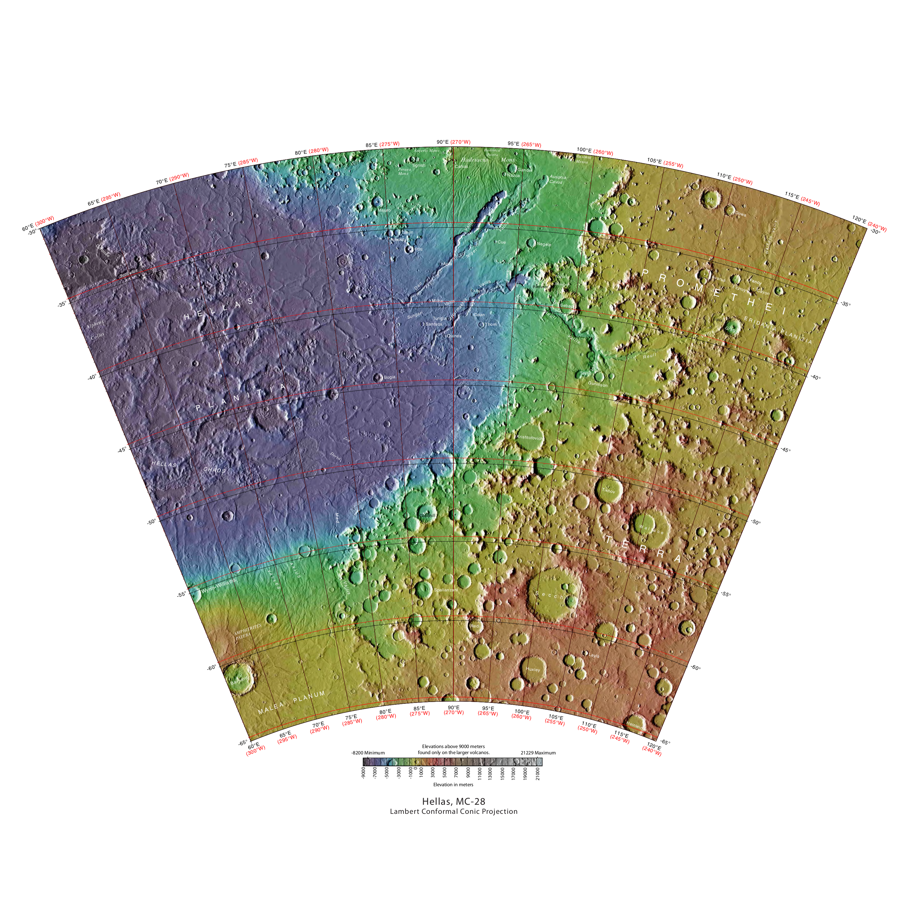
The Hellas quadrangle is one of a series of 30 quadrangle maps of Mars used by the United States Geological Survey (USGS) Astrogeology Research Program. The Hellas quadrangle is also referred to as MC-28 (Mars Chart-28). The Hellas quadrangle covers the area from 240° to 300° west longitude and 30° to 65° south latitude on the planet Mars. Within the Hellas quadrangle lies the classic features Hellas Planitia and Promethei Terra. Many interesting and mysterious features have been discovered in the Hellas quadrangle, including the giant river valleys Dao Vallis, Niger Vallis, Harmakhis, and Reull Vallis—all of which may have contributed water to a lake in the Hellas basin in the distant past. Many places in the Hellas quadrangle show signs of ice in the ground, especially places with glacier-like flow features. Hellas Basin The Hellas quadrangle contains part of the Hellas Basin, the largest known impact crater on the surface of Mars and the second largest in the solar sys ... [...More Info...] [...Related Items...] OR: [Wikipedia] [Google] [Baidu] |
Ismenius Lacus Quadrangle
The Ismenius Lacus quadrangle is one of a series of 30 quadrangle maps of Mars used by the United States Geological Survey (USGS) Astrogeology Research Program. The quadrangle is located in the northwestern portion of Mars’ eastern hemisphere and covers 0° to 60° east longitude (300° to 360° west longitude) and 30° to 65° north latitude. The quadrangle uses a Lambert conformal conic projection at a nominal scale of 1:5,000,000 (1:5M). The Ismenius Lacus quadrangle is also referred to as MC-5 (Mars Chart-5). The southern and northern borders of the Ismenius Lacus quadrangle are approximately and wide, respectively. The north-to-south distance is about (slightly less than the length of Greenland). The quadrangle covers an approximate area of 4.9 million square km, or a little over 3% of Mars’ surface area. The Ismenius Lacus quadrangle contains parts of Acidalia Planitia, Arabia Terra, Vastitas Borealis, and Terra Sabaea. The Ismenius Lacus quadrangle contains Deute ... [...More Info...] [...Related Items...] OR: [Wikipedia] [Google] [Baidu] |
Arcadia Quadrangle
The Arcadia quadrangle is one of a series of 30 quadrangle maps of Mars used by the United States Geological Survey (USGS) Astrogeology Research Program. The quadrangle is located in the north-central portion of Mars’ western hemisphere and covers 240° to 300° east longitude (60° to 120° west longitude) and 30° to 65° north latitude. The quadrangle uses a Lambert conformal conic projection at a nominal scale of 1:5,000,000 (1:5M). The Arcadia quadrangle is also referred to as MC-3 (Mars Chart-3). The southern and northern borders of the Arcadia quadrangle are approximately 3,065 km and 1,500 km wide, respectively. The north to south distance is about 2,050 km (slightly less than the length of Greenland). The quadrangle covers an approximate area of 4.9 million square km, or a little over 3% of Mars’ surface area. The region called Tempe Terra is in the Arcadia quadrangle. Several features found in this quadrangle are interesting, especially gullies w ... [...More Info...] [...Related Items...] OR: [Wikipedia] [Google] [Baidu] |
Mars Odyssey
''2001 Mars Odyssey'' is a robotic spacecraft orbiting the planet Mars. The project was developed by NASA, and contracted out to Lockheed Martin, with an expected cost for the entire mission of US$297 million. Its mission is to use spectrometers and a thermal imager to detect evidence of past or present water and ice, as well as study the planet's geology and radiation environment. It is hoped that the data ''Odyssey'' obtains will help answer the question of whether life existed on Mars and create a risk-assessment of the radiation that future astronauts on Mars might experience. It also acts as a relay for communications between the ''Curiosity'' rover, and previously the Mars Exploration Rovers and ''Phoenix'' lander, to Earth. The mission was named as a tribute to Arthur C. Clarke, evoking the name of his and Stanley Kubrick's 1968 film '' 2001: A Space Odyssey''. ''Odyssey'' was launched April 7, 2001, on a Delta II rocket from Cape Canaveral Air Force Station, and ... [...More Info...] [...Related Items...] OR: [Wikipedia] [Google] [Baidu] |
Phoenix (spacecraft)
''Phoenix'' was an uncrewed space probe that landed on the surface of Mars on May 25, 2008, and operated until November 2, 2008. ''Phoenix'' was operational on Mars for sols ( days). Its instruments were used to assess the local habitability and to research the history of water on Mars. The mission was part of the Mars Scout Program; its total cost was $420 million, including the cost of launch. The multi-agency program was led by the Lunar and Planetary Laboratory at the University of Arizona, with project management by NASA's Jet Propulsion Laboratory. Academic and industrial partners included universities in the United States, Canada, Switzerland, Denmark, Germany, the United Kingdom, NASA, the Canadian Space Agency, the Finnish Meteorological Institute, Lockheed Martin Space Systems, MacDonald Dettwiler & Associates (MDA) and other aerospace companies. It was the first NASA mission to Mars led by a public university. ''Phoenix'' was NASA's sixth successful landing on Ma ... [...More Info...] [...Related Items...] OR: [Wikipedia] [Google] [Baidu] |
Brain Terrain
Brain terrain, also called knobs-brain coral and brain coral terrain, is a feature of the Martian surface, consisting of complex ridges found on lobate debris aprons, lineated valley fill and concentric crater fill. It is so named because it suggests the ridges on the surface of the human brain. Wide ridges are called ''closed-cell'' brain terrain, and the less common narrow ridges are called ''open-cell'' brain terrain.Levy, J., J. Head, D. Marchant. 2009. Concentric crater fill in Utopia Planitia: History and interaction between glacial “brain terrain” and periglacial mantle processes. Icarus 202, 462–476. It is thought that the wide closed-cell terrain contains a core of ice, and when the ice disappears the center of the wide ridge collapses to produce the narrow ridges of the open-cell brain terrain. Shadow measurements from HiRISE indicate the ridges are 4-5 meters high. Brain terrain has been observed to form from what has been called an " Upper Plains Unit." The process ... [...More Info...] [...Related Items...] OR: [Wikipedia] [Google] [Baidu] |


