|
Typhoon Della (1968)
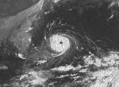
Typhoon Della, known in Japan as the 3rd Miyakojima Typhoon ( 第3宮古島台風) and in the Philippines as Typhoon Maring, was a typhoon that struck Miyakojima of Ryukyu Islands and Kyūshū Island in September 1968. Meteorological history Della passed near Miyakojima on September 22nd. After that, it proceeded along the Nansei Islands and landed near Kushikino City, Kagoshima Prefecture on the 24th. Impact Due to the typhoon, storms in Miyakojima caused major damage to homes and crops. In Kagoshima prefecture, the damage caused by salt wind and storm surge was great. On the Pacific side of western Japan, heavy rainfall caused flood damage. The typhoon killed 11 people and injured 80 in Japan. In addition, more than 20,000 houses were damaged. Della caused a great deal of damage to Miyakojima, so the Japan Meteorological Agency named Della the "''3rd Miyakojima Typhoon''". In the past, Typhoon Sarah in 1959 and Typhoon Cora in 1966 struck Miyako Island as ... [...More Info...] [...Related Items...] OR: [Wikipedia] [Google] [Baidu] |
1968 Pacific Typhoon Season
The 1968 Pacific typhoon season has no official bounds; it ran year-round in 1968, but most tropical cyclones tend to form in the northwestern Pacific Ocean between June and December. These dates conventionally delimit the period of each year when most tropical cyclones form in the northwestern Pacific Ocean. The scope of this article is limited to the Pacific Ocean, north of the equator and west of the International Date Line. Storms that form east of the date line and north of the equator are called hurricanes; see 1968 Pacific hurricane season. Tropical Storms formed in the entire west pacific basin were assigned a name by the Joint Typhoon Warning Center. Tropical depressions in this basin have the "W" suffix added to their number. Tropical depressions that enter or form in the Philippine area of responsibility are assigned a name by the Philippine Weather Bureau, the predecessor of the Philippine Atmospheric, Geophysical and Astronomical Services Administration (PAGASA). This ... [...More Info...] [...Related Items...] OR: [Wikipedia] [Google] [Baidu] |
Miyako-jima
is the largest and the most populous island among the Miyako Islands of Okinawa Prefecture, Japan. Miyako Island is administered as part of the City of Miyakojima, which includes not only Miyako Island, but also five other populated islands. Geography Miyako-jima lies approximately southwest of Okinawa Island. With an area of , Miyako is the fourth-largest island in Okinawa Prefecture. The island is triangular in shape and is composed of limestone. Miyako-jima is subject to drought and is frequently struck by typhoons. Miyako-jima is well known for its beauty, particularly the , a nationally designated Place of Scenic Beauty at the southeasternmost point of Miyako-jima. It is considered by many as one of the most beautiful spots in Japan. Other notable locations include Yonaha Maehama beach, Sunayama beach, Painagama Beach and the sights on Irabu-jima. There are three islands nearby which are connected by bridges to Miyako-jima, Irabujima (as of early 2015), , and . Ikem ... [...More Info...] [...Related Items...] OR: [Wikipedia] [Google] [Baidu] |
Ryukyu Islands
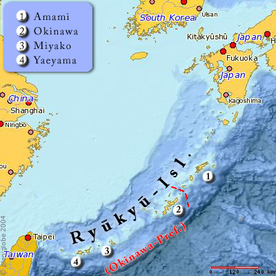
The , also known as the or the , are a chain of Japanese islands that stretch southwest from Kyushu to Taiwan: the Ōsumi, Tokara, Amami, Okinawa, and Sakishima Islands (further divided into the Miyako and Yaeyama Islands), with Yonaguni the westernmost. The larger are mostly high islands and the smaller mostly coral. The largest is Okinawa Island. The climate of the islands ranges from humid subtropical climate (Köppen climate classification ''Cfa'') in the north to tropical rainforest climate (Köppen climate classification ''Af'') in the south. Precipitation is very high and is affected by the rainy season and typhoons. Except the outlying Daitō Islands, the island chain has two major geologic boundaries, the Tokara Strait (between the Tokara and Amami Islands) and the Kerama Gap (between the Okinawa and Miyako Islands). The islands beyond the Tokara Strait are characterized by their coral reefs. The Ōsumi and Tokara Islands, the northernmost of the islands, fall un ... [...More Info...] [...Related Items...] OR: [Wikipedia] [Google] [Baidu] |
Kyushu
is the third-largest island of Japan's five main islands and the most southerly of the four largest islands ( i.e. excluding Okinawa). In the past, it has been known as , and . The historical regional name referred to Kyushu and its surrounding islands. Kyushu has a land area of and a population of 14,311,224 in 2018. In the 8th-century Taihō Code reforms, Dazaifu was established as a special administrative term for the region. Geography The island is mountainous, and Japan's most active volcano, Mount Aso at , is on Kyushu. There are many other signs of tectonic activity, including numerous areas of hot springs. The most famous of these are in Beppu, on the east shore, and around Mt. Aso in central Kyushu. The island is separated from Honshu by the Kanmon Straits. Being the nearest island to the Asian continent, historically it is the gateway to Japan. The total area is which makes it the 37th largest island in the world. It's slightly larger than Taiwan island . ... [...More Info...] [...Related Items...] OR: [Wikipedia] [Google] [Baidu] |
Kushikino, Kagoshima
is the name of a former city municipality located in Kagoshima Prefecture, Japan. It was founded under that name on 1 October 1950. In 2003, Kushikino had an estimated 26,355 inhabitants and covered an area 80.46 km², giving a population density of 327.55 persons per km². On 11 October 2005, Kushikino and the town of Ichiki (part of Hioki District) were merged to form the new city of Ichikikushikino is a Cities of Japan, city located in Kagoshima Prefecture, Japan. The modern city of Ichikikushikino was established on October 11, 2005, from the merger of the city of Kushikino, Kagoshima, Kushikino with the town of Ichiki, Kagoshima, Ichiki ..., so that Kushikino no longer exists as an independent municipality. External links Ichikikushikino official websitein Japanese Dissolved municipalities of Kagoshima Prefecture {{Kagoshima-geo-stub ... [...More Info...] [...Related Items...] OR: [Wikipedia] [Google] [Baidu] |
Kagoshima Prefecture
is a prefecture of Japan located on the island of Kyushu and the Ryukyu Islands. Kagoshima Prefecture has a population of 1,599,779 (1 January 2020) and has a geographic area of 9,187 km2 (3,547 sq mi). Kagoshima Prefecture borders Kumamoto Prefecture to the north and Miyazaki Prefecture to the northeast. Kagoshima is the capital and largest city of Kagoshima Prefecture, with other major cities including Kirishima, Kanoya, and Satsumasendai. Kagoshima Prefecture is located at the southernmost point of Kyūshū and includes the Satsunan Islands group of the Ryukyu Islands. Kagoshima Prefecture's mainland territory extends from the Ariake Sea to Shibushi Bay on the Pacific Ocean coast, and is characterized by two large peninsulas created by Kagoshima Bay. Kagoshima Prefecture formed the core of the Satsuma Domain, ruled from Kagoshima Castle, one of the most important Japanese domains of the Edo period and the Meiji Restoration. History Kagoshima Prefecture correspo ... [...More Info...] [...Related Items...] OR: [Wikipedia] [Google] [Baidu] |
Japan Meteorological Agency
The , abbreviated JMA, is an agency of the Ministry of Land, Infrastructure, Transport and Tourism. It is charged with gathering and providing results for the public in Japan that are obtained from data based on daily scientific observation and research into natural phenomena in the fields of meteorology, hydrology, seismology and volcanology, among other related scientific fields. Its headquarters is located in Minato, Tokyo. JMA is responsible for gathering and reporting weather data and forecasts for the general public, as well as providing aviation and marine weather. JMA other responsibilities include issuing warnings for volcanic eruptions, and the nationwide issuance of earthquake warnings of the Earthquake Early Warning (EEW) system. JMA is also designated one of the Regional Specialized Meteorological Centers of the World Meteorological Organization (WMO). It is responsible for forecasting, naming, and distributing warnings for tropical cyclones in the Northwestern ... [...More Info...] [...Related Items...] OR: [Wikipedia] [Google] [Baidu] |
Typhoon Sarah (1959)
Typhoon Sarah, as known as the Miyakojima Typhoon in Japan was among the deadliest typhoons on record in the western Pacific Ocean, killing around 2,000 people. It formed during the peak of the busy 1959 Pacific typhoon season near Guam, and moved generally to the west-northwest. Continued observations from the hurricane hunters allowed the Joint Typhoon Warning Center (JTWC) to track Sarah from its origins to its peak as a powerful typhoon, with maximum sustained winds estimated at on September 15. Shortly thereafter, the typhoon struck the small Japanese island of Miyako-jima, where the barometric pressure fell to , the second-lowest on record for the country. Sarah turned to the north and northeast, weakening from its peak intensity. On September 17, the typhoon made landfall just west of Busan, South Korea with winds of , the nation's strongest landfall at the time and only to be surpassed by Typhoon Maemi in 2003. Sarah later became extratropical over the Japan ... [...More Info...] [...Related Items...] OR: [Wikipedia] [Google] [Baidu] |
Typhoon Cora (1966)
Typhoon Cora, also known as the 2nd Miyakojima Typhoon ( 第2宮古島台風) in Japan, was a typhoon that hit the Ryūkyū Islands in 1966 Events January * January 1 – In a coup, Colonel Jean-Bédel Bokassa takes over as military ruler of the Central African Republic, ousting President David Dacko. * January 3 – 1966 Upper Voltan coup d'état: President Maurice Yaméogo i .... Meteorological history At 18:00 Coordinated Universal Time, UTC on August 28, a tropical cyclone#tropical depression, tropical depression formed just to the east of the Northern Mariana Islands. Although initially drifting southeast, the depression began curving to the southwest early the next day. During the late night of August 29, it passed over the south tip of Guam and over the Cocos Lagoon. Early in the day on August 30, the depression slowed its course and began a gentle turn to the west-northwest. By 00:00 UTC on August 31, the depression attained tropical cyclone#tropical storm, trop ... [...More Info...] [...Related Items...] OR: [Wikipedia] [Google] [Baidu] |
Miyako Islands
The (also Miyako Jima group) are a group of islands in Okinawa Prefecture, Japan, belonging to the Ryukyu Islands. They are situated between the Okinawa Island and Yaeyama Islands. In the early 1870s, the population of the islands was estimated to number approximately 10,000. Miyako island has 55,914 people. A bridge connects Miyako Island to Ikema Island, which has 801 people. Tarama village has 1,214 people, between the two islands of Minna and Tarama. Important Bird Area The islands have been recognised as an Important Bird Area (IBA) by BirdLife International because they support populations of the resident Ryukyu green pigeons, as well as migrating whimbrels. Inhabited islands * Miyakojima City ** ** ** ** ** ( ja) ** * Tarama Village ( Miyako District) ** ** ( ja) See also * Miyako people *Sakishima Islands *Miyakoan language *Miyako Strait The , also known as the Kerama Gap, is a waterway which lies between Miyako Island and Okinawa Island consisting of a ... [...More Info...] [...Related Items...] OR: [Wikipedia] [Google] [Baidu] |
1968 In Japan
Events in the year 1968 in Japan. Incumbents *Emperor: Hirohito *Prime Minister: Eisaku Satō (Liberal Democratic) *Chief Cabinet Secretary: Toshio Kimura until November 30, Shigeru Hori *Chief Justice of the Supreme Court: Masatoshi Yokota *President of the House of Representatives: Mitsujirō Ishii *President of the House of Councillors: Yūzō Shigemune Governors *Aichi Prefecture: Mikine Kuwahara *Akita Prefecture: Yūjirō Obata *Aomori Prefecture: Shunkichi Takeuchi *Chiba Prefecture: Taketo Tomonō *Ehime Prefecture: Sadatake Hisamatsu *Fukui Prefecture: Heidayū Nakagawa *Fukuoka Prefecture: Hikaru Kamei *Fukushima Prefecture: Morie Kimura *Gifu Prefecture: Saburō Hirano *Gunma Prefecture: Konroku Kanda *Hiroshima Prefecture: Iduo Nagano *Hokkaido: Kingo Machimura *Hyogo Prefecture: Motohiko Kanai *Ibaraki Prefecture: Nirō Iwakami *Ishikawa Prefecture: Yōichi Nakanishi *Iwate Prefecture: Tadashi Chida *Kagawa Prefecture: Masanori Kaneko *Kagoshima ... [...More Info...] [...Related Items...] OR: [Wikipedia] [Google] [Baidu] |


