|
Tsipa
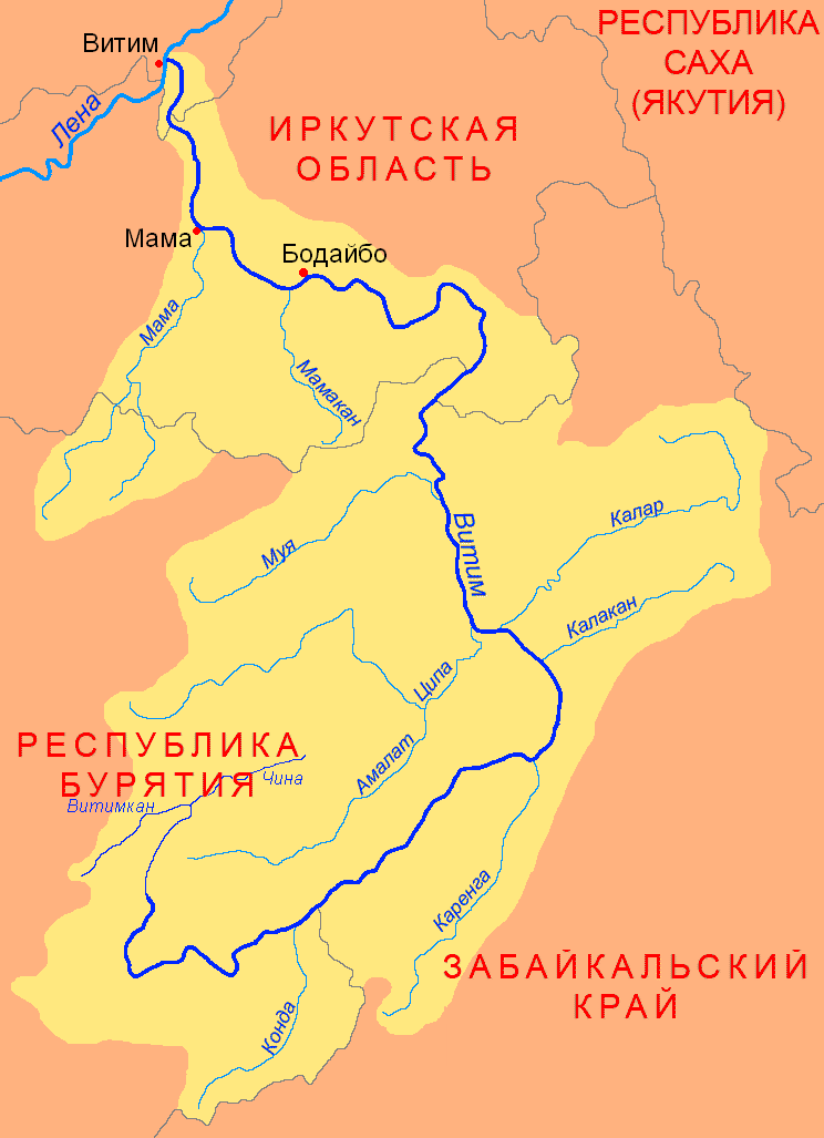
The Tsipa (russian: Ципа) is the largest tributary of the Vitim in Buryatia, Russia. It is long, and has a drainage basin of . Maksim Perfilyev was the first Russian to reach the Tsipa in 1640. Perch, pike, lenok, grayling, taimen and whitefish are also found in the waters of the Tsipa. Course The Tsipa is a western, left tributary of the Vitim. It has its sources in a tarn of the Southern Muya Range, in the area where this range merges with the Ikat Range. It is known as "Upper Tsipa" (Верхняя Ципа) in its upper course until its mouth in lake Baunt in the Baunt Depression in the northeastern part of the Vitim Plateau, near the Bolshoy Khapton Range. The river flows out of the lake in a NNE direction and slows down meandering across a swampy basin where there are many lakes, the largest of which is Busani. Then it turns south and crosses the Babanty Range through a narrow valley where it flows fast, forming rapids. After leaving the mountains it turns again nor ... [...More Info...] [...Related Items...] OR: [Wikipedia] [Google] [Baidu] |
Baunt
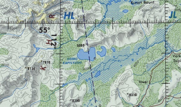
Baunt (russian: Баунт; bxr, Баунт нуур, ''Baunt nuur'') is the name of a body of fresh water in the Bauntovsky District, Buryatia, Russia. The village of Kurort Baunt, where there are some hot springs, is located on the southwestern shore of the lake, at the foot of Mt Bolshoy Khapton, near the confluence of the Upper Tsipa, and the village of Baunt is on the northeastern shore. At a headland named Cape Tryokhstanka there are ancient petroglyphs. The lake is a protected area since 1988. Its environment provides a habitat for a number of fish and bird species, as well as the crustacean ''Asellus aquaticus''. Geography The lake has a roughly triangular shape. It stretches in a southwest-northeast direction parallel to the main ridge of the Southern Muya Range to the north and the Baunt Basin, with the Maly Khapton and Babanty Range, two ranges of the Vitim Plateau, to the south. The Ikat Range rises to the west and the Kapylyushi lakes lie to the southwest. The Upper ... [...More Info...] [...Related Items...] OR: [Wikipedia] [Google] [Baidu] |
Amalat
The Amalat (russian: Амалат) is a river in Buryatia, Russia. It is the largest tributary of the Tsipa, of the Vitim basin.Ципа / '':'' in 30 vols. / Ch. ed. A.M. Prokhorov. - 3rd ed. - M. Soviet Encyclopedia, 1969-1978. The river is long, and has a drainage basin of . The villages of Baysa, and |
Tsipikan (river)
The Tsipikan (russian: Ципикан) is a river in Buryatia, Russia. It is the second largest tributary of the Tsipa, after the Amalat, of the Vitim basin. The river is long, and has a drainage basin of . There is gold mining in the banks of the river. Course The Tsipikan is a tributary of the Tsipa. It has its sources in the eastern slopes of the Ikat Range. First it flows northeastwards as it progresses across the mountains of the northwestern corner of the Vitim Plateau. Its course slows down and becomes marshy in the Kapylyushi lake area, south of the slopes of the Bolshoy Khapton. After a sharp turn to the southeast, and then northeast, it ends up flowing northwards meandering strongly and finally entering the eastern shore of lake Baunt. Tsipikan village is located on the right bank of the river. There are many swampy stretches in the Tsipikan basin, as well as 863 lakes with a total area of . The main tributaries of the Tsipikan are the long Taloy from the right, an ... [...More Info...] [...Related Items...] OR: [Wikipedia] [Google] [Baidu] |
Baunt Depression
Baunt (russian: Баунт; bxr, Баунт нуур, ''Baunt nuur'') is the name of a body of fresh water in the Bauntovsky District, Buryatia, Russia. The village of Kurort Baunt, where there are some hot springs, is located on the southwestern shore of the lake, at the foot of Mt Bolshoy Khapton, near the confluence of the Upper Tsipa, and the village of Baunt is on the northeastern shore. At a headland named Cape Tryokhstanka there are ancient petroglyphs. The lake is a protected area since 1988. Its environment provides a habitat for a number of fish and bird species, as well as the crustacean ''Asellus aquaticus''. Geography The lake has a roughly triangular shape. It stretches in a southwest-northeast direction parallel to the main ridge of the Southern Muya Range to the north and the Baunt Basin, with the Maly Khapton and Babanty Range, two ranges of the Vitim Plateau, to the south. The Ikat Range rises to the west and the Kapylyushi lakes lie to the southwest. The Upper ... [...More Info...] [...Related Items...] OR: [Wikipedia] [Google] [Baidu] |
Busani
Busani (russian: Бусани) is the name of a body of fresh water in the Bauntovsky District, Buryatia, Russia. The name originated in the Evenki language, meaning "where people drown". There are spectacular rock formations on the southeastern shore of lake Busani. It was declared a protected area of Russia on 25 July 1988. Geography Busani is one of the major lakes of the Baunt Depression, below the southern foothills of the Southern Muya Range.Busani / '':'' in 30 vols. / Ch. ed. . - 3rd ed. - M. Soviet Encyclopedia, 1969-1978. ... [...More Info...] [...Related Items...] OR: [Wikipedia] [Google] [Baidu] |
Vitim (river)
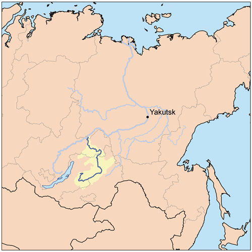
The Vitim (russian: Витим; evn, Витым, ; sah, Виитим, ; Buryat and mn, Витим, ''Vitim'') is a major tributary of the Lena. Its source is east of Lake Baikal, at the confluence of rivers Vitimkan from the west and China from the east. The Vitim flows first south, bends eastwards and then northward in the Vitim Plateau. Then it flows north through the Stanovoy Highlands and the town of Bodaybo. Including river Vitimkan, its western source, it is long, and has a drainage basin of .Витим (река в Бурят. АССР) It is navigable from the Lena to Bodaybo. Upstream, ... [...More Info...] [...Related Items...] OR: [Wikipedia] [Google] [Baidu] |
List Of Rivers Of Russia
Russia can be divided into a European and an Asian part. The dividing line is generally considered to be the Ural Mountains. The European part is drained into the Arctic Ocean, Baltic Sea, Black Sea, and Caspian Sea. The Asian part is drained into the Arctic Ocean and the Pacific Ocean. Notable rivers of Russia in Europe are Volga (which is the longest river in Europe), Pechora, Don, Kama, Oka and the Northern Dvina, while several other rivers originate in Russia but flow into other countries, such as the Dnieper and the Western Dvina. In Asia, important rivers are the Ob, the Irtysh, the Yenisei, the Angara, the Lena, the Amur, the Yana, the Indigirka, and the Kolyma. In the list below, the rivers are grouped by the seas or oceans into which they flow. Rivers that flow into other rivers are ordered by the proximity of their point of confluence to the mouth of the main river, i.e., the lower in the list, the more upstream. There is an alphabetical list of rivers at the end of ... [...More Info...] [...Related Items...] OR: [Wikipedia] [Google] [Baidu] |
Bolshoy Khapton
The Bolshoy Khapton (russian: Большой Хаптон) is a mountain range in Bauntovsky District, Buryatia, Russia. The nearest airport is Bagdarin Airport.Google Earth Geography This mountain range is located in the northeastern part of the Vitim Plateau. It stretches from southwest to northeast for almost 50 km between the Kapylyushi lake group and the southern shores of Baunt lake. The Bolshoy Khapton range is part of the watershed of the Tsipikan and Upper Tsipa rivers. In its eastern section it reaches a maximum width of 10 km. The highest point of the range is high Mt Bolshoy Khapton. to the south, across the Tsipikan River, rises the smaller Maly Khapton range, highest point . It runs parallel to the Bolshoy Khapton at the southern limit of the Baunt Depression. See also *List of mountains and hills of Russia This is a list of mountains and hills of Russia. List by elevation Over 5000 meters 4000 to 4999 meters 3000 to 3999 meters 2000 to 2999 meter ... [...More Info...] [...Related Items...] OR: [Wikipedia] [Google] [Baidu] |
Vitim Plateau
Vitim Plateau is a plateau in Buryatia and Zabaykalsky Krai, Russia. The plateau is sparsely populated, the main settlements are Romanovka and Bagdarin. An area of the plateau is an ancient volcanic field with a number of cinder cones and volcanoes, the last of which was active about 810,000 years before present. The P436 regional road connecting Ulan-Ude and Chita passes through Romanovka across the plateau. Geography The Vitim Plateau lies along the headwaters of the Vitim River, a tributary of the Lena between the Southern Muya Range to the north, the Ikat Range to the west, the Yablonoi Mountains to the south, and in the east with the lower reaches of the Kalakan River to the right bank of the lower reaches of the Karenga River (both Vitim tributaries) and the latter's right tributary, the Bugarikta. The Vitim River begins at the confluence of the China and Vitimkan rivers on the plateau and makes a wide bend around the volcanic zone before flowing northwards. Rive ... [...More Info...] [...Related Items...] OR: [Wikipedia] [Google] [Baidu] |
Ikat Range
Ikat Range () is a mountain range in Buryatia, Russia. It runs in a parallel direction to the Baikal Rift. The range is named after two small rivers sharing the name "Ikat" which have their sources in opposite slopes of the range one is a tributary of the Gargi (Barguzin basin) and the other a tributary of the Vitimkan (Vitim basin). The name of the range originated in an Evenki word. A section of the northwestern slopes of the range is part of the Dzherginsky Nature Reserve, a protected area.Google Earth Geography The Ikat range is located in Central Buryatia, east of the Baikal Lake. It stretches for from southwest to northeast at the western limit of the Vitim Plateau. The width of the range is from and and its average elevation between and .Икатский хребет |
Maksim Perfilyev
Maksim Perfilyev (russian: Максим Перфильев (b. 1580 – d. 1638) was a Cossack explorer of Eastern Siberia and the first Russian to reach Transbaikalia. He was renowned for his diplomatic skills in negotiations with Tunguses, Mongols and Chinese. In 1618–19 Perfilyev was co-founder of Yeniseysky ostrog, the first Russian fort at the central part of the great Siberian river Yenisey, a major starting point for further expeditions eastward. From 1618–27 he made several journeys on the Angara and Ilim rivers, and built several new ostrogs. In 1631 he founded Bratsky ostrog (modern Bratsk). In 1639–40 he sailed up the Vitim River as far as the Tsipa thereby becoming the first Russian to enter Transbaikalia, then known as Dauria. Perfilyev gave his name to the village of Maksimovschina, where on the banks of the Irkut River were his hunting lands. Maksimikha Bay on Lake Baikal (part of the larger Barguzin Bay) and Cape Maksimin in that bay, as well as t ... [...More Info...] [...Related Items...] OR: [Wikipedia] [Google] [Baidu] |
Thymallus
''Thymallus'' is a genus of freshwater fish in the salmon family Salmonidae; it is the only genus of subfamily Thymallinae. The type species is ''Thymallus thymallus,'' the grayling. The species in the genus are generically called graylings, but without qualification this also refers specifically to ''T. thymallus.'' Distribution The fishes of this genus are native to the northern parts of the Palearctic and Nearctic realms, ranging from the United Kingdom and northern Europe across Eurasia to Siberia, as well as northern North America. ''T. thymallus'', the grayling, is widespread in Europe, and ''T. arcticus,'' the Arctic grayling, is widespread throughout Eurasia east of the Ural Mountains and in the Nearctic. The other species have more localized ranges in northern Asia. Appearance ''Thymallus'' species are distinguished from other members of the salmon family by their larger scales, their small mouths with teeth on the maxillary bone, and most striking of all, their showy, ... [...More Info...] [...Related Items...] OR: [Wikipedia] [Google] [Baidu] |


