|
Tropical Depression Auring (2009)
Tropical Depression Auring formed as a tropical disturbance late on December 30, 2008, to the southeast of Manila in the Philippines. Over the next few days the disturbance gradually developed before early on January 3, the Philippine Atmospheric, Geophysical and Astronomical Services Administration (PAGASA) and the Japan Meteorological Agency (JMA), reported that the disturbance had intensified into the first tropical depression of the season with PAGASA assigning the name Auring to the depression. As the Depression was moving into a high level of vertical wind shear, it did not develop any further and late on January 5 as the baroclinic zone approached Auring, it was downgraded to an area of low pressure by the PAGASA before the JMA followed suit the next day as it was declared as dissipated by the JTWC. Heavy rain from Auring produced severe flooding in the eastern Philippines. Two people were killed and nine others were left missing. A total of 305 homes were destroyed and an ... [...More Info...] [...Related Items...] OR: [Wikipedia] [Google] [Baidu] |
Philippines
The Philippines (; fil, Pilipinas, links=no), officially the Republic of the Philippines ( fil, Republika ng Pilipinas, links=no), * bik, Republika kan Filipinas * ceb, Republika sa Pilipinas * cbk, República de Filipinas * hil, Republika sang Filipinas * ibg, Republika nat Filipinas * ilo, Republika ti Filipinas * ivv, Republika nu Filipinas * pam, Republika ning Filipinas * krj, Republika kang Pilipinas * mdh, Republika nu Pilipinas * mrw, Republika a Pilipinas * pag, Republika na Filipinas * xsb, Republika nin Pilipinas * sgd, Republika nan Pilipinas * tgl, Republika ng Pilipinas * tsg, Republika sin Pilipinas * war, Republika han Pilipinas * yka, Republika si Pilipinas In the recognized optional languages of the Philippines: * es, República de las Filipinas * ar, جمهورية الفلبين, Jumhūriyyat al-Filibbīn is an archipelagic country in Southeast Asia. It is situated in the western Pacific Ocean and consists of around 7,641 islands t ... [...More Info...] [...Related Items...] OR: [Wikipedia] [Google] [Baidu] |
Auring 3 January 2009
The name Auring has been used for sixteen tropical cyclones in the Philippines by PAGASA and its predecessor, the Philippine Weather Bureau, in the Western Pacific Ocean. * Typhoon Polly (1963) (T6302, 09W, Auring) * Tropical Storm Ruby (1967) (T6701, 01W, Auring) * Tropical Storm Sarah (1971) (T7101, 01W, Auring) * Typhoon Lola (1975) (T7501, 01W, Auring), struck the Philippines * Typhoon Bess (1979) (T7902, 02W, Auring) * Typhoon Tip (1983) (T8302, 02W, Auring), struck the Philippines and China * Typhoon Orchid (1987) (T8701, 01W, Auring), extensive damage on Ulithi Atoll but no deaths reported * Tropical Storm Sharon (1991) (T9101, 01W, Auring), struck the Philippines * Tropical Storm Deanna (1995) (T9502, 03W, Auring), struck the Philippines * Tropical Storm Hilda (1999) (01W, Auring, Japan Meteorological Agency analyzed it as a tropical depression, not as a tropical storm), brought heavy rain to Sabah * Tropical Depression Auring (2001) (01W), a tropical depression th ... [...More Info...] [...Related Items...] OR: [Wikipedia] [Google] [Baidu] |
Hectare
The hectare (; SI symbol: ha) is a non-SI metric unit of area equal to a square with 100-metre sides (1 hm2), or 10,000 m2, and is primarily used in the measurement of land. There are 100 hectares in one square kilometre. An acre is about and one hectare contains about . In 1795, when the metric system was introduced, the ''are'' was defined as 100 square metres, or one square decametre, and the hectare ("hecto-" + "are") was thus 100 ''ares'' or km2 (10,000 square metres). When the metric system was further rationalised in 1960, resulting in the International System of Units (), the ''are'' was not included as a recognised unit. The hectare, however, remains as a non-SI unit accepted for use with the SI and whose use is "expected to continue indefinitely". Though the dekare/decare daa (1,000 m2) and are (100 m2) are not officially "accepted for use", they are still used in some contexts. Description The hectare (), although not a unit of SI, i ... [...More Info...] [...Related Items...] OR: [Wikipedia] [Google] [Baidu] |
Talisay City, Cebu
Talisay, officially the City of Talisay ( ceb, Dakbayan sa Talisay; fil, Lungsod ng Talisay), is a 3rd class component city in the province of Cebu, Philippines. According to the 2020 census, it has a population of 263,048 people. The name of Talisay is taken from the talisay tree which is abundant in the city. History Talisay was founded in 1648 as an estate owned by the Augustinians. In 1849 it was converted into a municipality. During both the American colonial period and World War II, Talisay served as a haven of colonial military forces. The municipality served as the center of guerrilla intelligence operations for the Philippine resistance movement in Cebu during World War II. The returning U. S. liberation forces landed on the beaches of Talisay on March 28, 1945, and were helped together with the Philippine Commonwealth forces and the Cebuano guerrillas, an event that marked the eventual surrender of Japanese forces on Cebu. That day is now an official holiday in ... [...More Info...] [...Related Items...] OR: [Wikipedia] [Google] [Baidu] |
Gingoog City
Gingoog, officially the City of Gingoog ( ceb, Dakbayan sa Hingoog; fil, Lungsod ng Gingoog), is a 2nd class component city in the province of Misamis Oriental, Philippines. According to the 2020 census, it has a population of 136,698 people. Like other municipalities in the Philippines that retained Spanish-based orthography, the city name is spelled as ''Gingoog'' but is pronounced as or since it originated as a Binukid word. History The term Gingoog originally came from the word "Hingoog", which means "Goodluck", from a Lumad tribe of Manobo who settled in the area. The word implies good fortune, thus Gingoog City means the City of Good Luck. The natives of this place are the ones with the family names of "Gingco", and "Gingoyon". Gingoog was founded as a mission by Spanish missionaries in 1750. It was one of the oldest localities in Misamis Oriental Province, older than the province's capital and economic hub, Cagayan de Oro which was founded in 1871. It was made pa ... [...More Info...] [...Related Items...] OR: [Wikipedia] [Google] [Baidu] |
Cagayan River (Cagayan De Oro)
Cagayan River, often called the Cagayan de Oro River, is one of the rivers draining the northern central part of the island of Mindanao in the Philippines. The river has its headwaters in the Kalatungan Mountain Range and Kitanglad Mountain Range found in the central part of the province of Bukidnon. It traverses the municipalities of Talakag, Baungon and Libona, connecting tributaries along the way. It finally empties into the Macajalar Bay at Cagayan de Oro in the province of Misamis Oriental. The river serves as the natural boundary between the province of Bukidnon and Iligan and between Bukidnon and Cagayan de Oro, based on the administrative order issued by the defunct Department of Mindanao and Sulu during the American occupation of the Philippines. In Cagayan de Oro, it is the dividing line between its two Congressional districts. The Cagayan River is a very popular site for whitewater rafting in the Philippines and has been promoted by the Department of Tourism as th ... [...More Info...] [...Related Items...] OR: [Wikipedia] [Google] [Baidu] |
Eastern Samar
Eastern Samar (Waray-Waray: ''Sinirangan Samar''; tl, Silangang Samar), officially the Province of Eastern Samar, is a province in the Philippines located in the Eastern Visayas region. Its capital is the city of Borongan. Eastern Samar occupies the eastern portion of the island of Samar. Bordering the province to the north is the province of Northern Samar and to the west is Samar province. To the east lies the Philippine Sea, part of the vast Pacific Ocean, while to the south lies the Leyte Gulf. History Colonial period During his circumnavigation of the globe, Ferdinand Magellan had set foot on the tiny island of Homonhon in the southern part of the province. On March 16, 1521, the area of what is now Eastern Samar is said to be the first Philippine landmass spotted by Magellan and his crew. Philippine-American War Maj. Eugenio Daza Area Commander of General Lukbán's forces for Southeastern Samar Balangiga Encounter On September 28, 1901, Filipino guerrillas led by Va ... [...More Info...] [...Related Items...] OR: [Wikipedia] [Google] [Baidu] |
Biliran Island
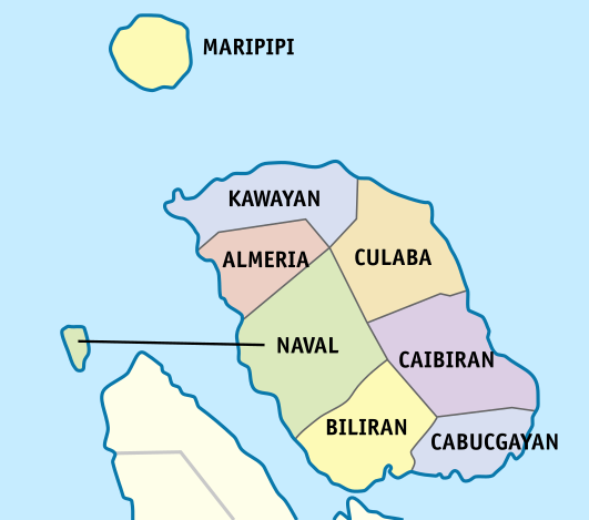
Biliran, officially the Province of Biliran ( Waray-Waray: ''Probinsya han Biliran''; ceb, Lalawigan sa Biliran; tl, Lalawigan ng Biliran), is an island province in the Philippines located in the Eastern Visayas region (Region VIII). Biliran is one of the country's smallest and newest provinces. Formerly a sub-province of Leyte, it became an independent province in 1992. Biliran lies less than a kilometer north of the island of Leyte. A bridge-causeway fixed link over Poro Island in the gateway town of Biliran connects the province to Leyte. Its capital is the municipality of Naval on the western coast of the island. History Etymology During the early Spanish era, what is now called Biliran was known as ''Isla de Panamao''. The present name, believed to be adopted sometime between the late 17th century and the early 18th century, was, according to many publications, derived from a native grass called ''borobiliran'' which once grew abundantly on the island's plains. A contend ... [...More Info...] [...Related Items...] OR: [Wikipedia] [Google] [Baidu] |
Dinagat Island
Dinagat Island is an island located northeast of Mindanao in the Philippines. Until December 2006, it was part of the province of Surigao del Norte. Being its main island, almost all municipalities of the province of Dinagat Islands Dinagat Islands (Cebuano language, Cebuano: ''Mga Pulo sa Dinagat''; Surigaonon language, Surigaonon: ''Mga Puyo nan Dinagat''; Kabalian language, Kabalian: ''Mga Puyo san Dinagat''; Waray language, Waray: ''Mga Purô han Dinagat''; Filipino lang ... are located on it. External links * Islands of Dinagat Islands {{Caraga-geo-stub ... [...More Info...] [...Related Items...] OR: [Wikipedia] [Google] [Baidu] |
Siargao Island
Siargao is a tear-drop shaped island in the Philippine Sea situated 196 kilometers southeast of Tacloban. It has a land area of approximately . The east coast is relatively straight with one deep inlet, Port Pilar. The coastline is marked by a succession of reefs, small points and white, sandy beaches. The neighboring islands and islets have similar landforms. Siargao is known as the surfing capital of the Philippines, and was voted the Best Island in Asia in the 2021 Conde Nast Travelers Readers awards. The island is within the jurisdiction of the province of Surigao del Norte and is composed of the municipalities of Burgos, Dapa, Del Carmen, General Luna, San Benito, Pilar, San Isidro, and Santa Monica. Etymology The name originates from Visayan ''siargaw'' or '' saliargaw'' (''Premna odorata''), a mangrove species that grows on the islands. History The first recorded sighting by Europeans of Siargao Island was by Spanish navigator Bernardo de la Torre on board of the c ... [...More Info...] [...Related Items...] OR: [Wikipedia] [Google] [Baidu] |
Surigao Del Norte
Surigao del Norte ( Surigaonon: ''Probinsya nan Surigao del Norte''; ceb, Amihanang Surigao; Tagalog: ''Hilagang Surigao''), officially the Province of Surigao del Norte, is a province in the Philippines located in the Caraga region of Mindanao. The province was formerly under the jurisdiction of Region 10 (Northern Mindanao) until 1995. Its capital is Surigao City. The province comprises two major islands—Siargao and Bucas Grande—in the Philippine Sea, plus a small area at the northeastern tip of mainland Mindanao and other surrounding minor islands and islets. This mainland portion borders Agusan del Norte – between the Municipality of Alegria in Surigao del Norte and the Municipality of Kitcharao in Agusan del Norte; and the province of Surigao del Sur, to the south. Surigao del Norte is the second northernmost of the Mindanao provinces and is an important commerce and transportation hub between Visayas and Mindanao. Numerous ferries cross the Surigao Strait bet ... [...More Info...] [...Related Items...] OR: [Wikipedia] [Google] [Baidu] |
Camotes Islands
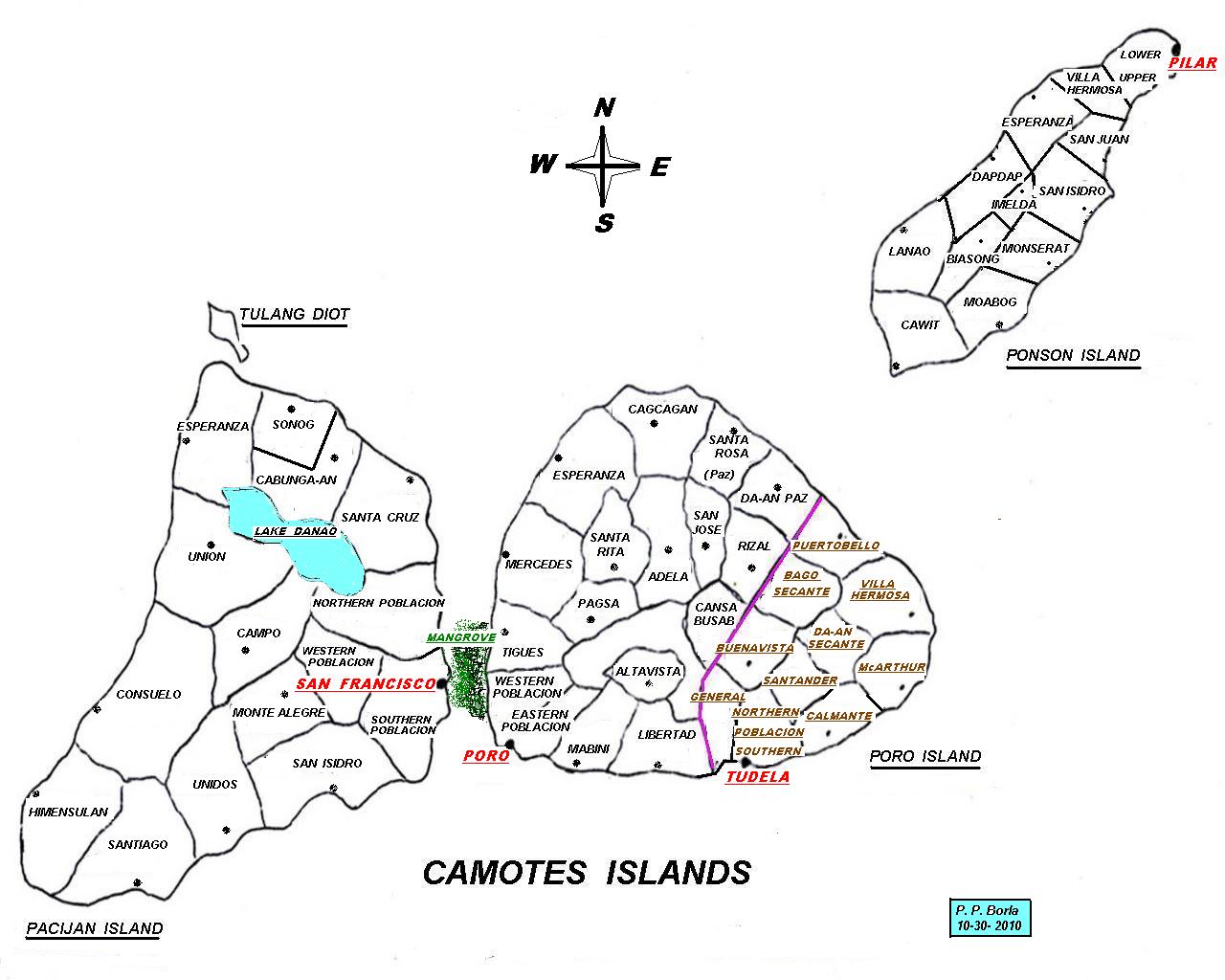
Camotes Islands is a group of islands in the Camotes Sea, Philippines. Combined area is . The island group is located east of Cebu Island, southwest of Leyte Island, and north of Bohol Island. It is from Cebu City and is part of Cebu. According to the 2015 census, it has a population of 102,996. Population has grown % since 1990, equivalent to an annual growth rate of . Nearest landfall, from north end of Ponson island to southern Leyte, is about . From Consuelo port to Danao is as the crow flies. From south of Pacijan to Bohol is about . Sometimes known as the "''Lost Horizon'' of the south", within recent years Camotes has seen increased visitors and tourism and a growing expatriate community. Apart from natural attractions on land, there is also a score of dive sites around the islands. Geography Camotes Islands comprises three major islands and one minor islet, divided between four municipalities. On Poro Island are the municipalities of Poro and Tudela. Pacijan Isla ... [...More Info...] [...Related Items...] OR: [Wikipedia] [Google] [Baidu] |


