|
Totness Airstrip
Totness Airstrip is an airport serving Totness, a town in and capital of the Coronie District in Suriname. This is one of the oldest airports in Suriname. The marked runway is . Including overruns extends it to . Charters and destinations Charter services for this airport are: See also * * * List of airports in Suriname * Transport in Suriname The Republic of Suriname ( nl, Republiek Suriname) has a number of forms of transport. Transportation emissions are an increasing part of Suriname's contributions to climate change, as part of the Nationally Determined Contributions for the Paris ... References External linksOpenStreetMap - Totness Airport Airp ... [...More Info...] [...Related Items...] OR: [Wikipedia] [Google] [Baidu] |
Luchtvaartdienst Suriname
The Luchtvaartdienst Suriname is the Civil Aviation Department of the Suriname Ministry of Transport, Communication and Tourism. It is responsible for the regulation of all aviation activities in the country, and ensures that all activities are carried out in compliance with international standards. It is a member of the International Civil Aviation Organization The International Civil Aviation Organization (ICAO, ) is a specialized agency of the United Nations that coordinates the principles and techniques of international air navigation, and fosters the planning and development of international sc ... (ICAO). In April 2010, John Veira, the head of Luchtvaartdienst Suriname, was killed in his home by gunmen. Dutch language Airports and Airst ...
|
Totness, Suriname
Totness is a town in Suriname, located in the Coronie district, of which it is the capital. Totness is the oldest settlement in the district. History Totness was settled by Scottish and English colonists from 1808 onward, and is named after Totnes, England. In 1863, the area around Totness was designated for independent agriculture. A market and a District Commissioner's Office on the former plantation Friendship were added to the resort. In the 1940s, a road was built linking Totness with Paramaribo which is nowadays part of the East-West Link. The Suriname-Guyana Submarine Cable System has its landing station in Totness. It connects the telecommunications networks in Suriname with those in Guyana and Trinidad and from Trinidad to the rest of the world. The Totness Airstrip is one of the oldest airports in Suriname, in use since 1953, when the Piper Cub (PZ-NAC) of Kappel-van Eyck named "Colibri" landed there from Zorg en Hoop Airport. Totness has been designated as a regional ... [...More Info...] [...Related Items...] OR: [Wikipedia] [Google] [Baidu] |
Airport
An airport is an aerodrome with extended facilities, mostly for commercial air transport. Airports usually consists of a landing area, which comprises an aerially accessible open space including at least one operationally active surface such as a runway for a plane to take off and to land or a helipad, and often includes adjacent utility buildings such as control towers, hangars and terminals, to maintain and monitor aircraft. Larger airports may have airport aprons, taxiway bridges, air traffic control centres, passenger facilities such as restaurants and lounges, and emergency services. In some countries, the US in particular, airports also typically have one or more fixed-base operators, serving general aviation. Operating airports is extremely complicated, with a complex system of aircraft support services, passenger services, and aircraft control services contained within the operation. Thus airports can be major employers, as well as important hubs for tourism ... [...More Info...] [...Related Items...] OR: [Wikipedia] [Google] [Baidu] |
Capital (political)
A capital city or capital is the municipality holding primary status in a country, state, province, department, or other subnational entity, usually as its seat of the government. A capital is typically a city that physically encompasses the government's offices and meeting places; the status as capital is often designated by its law or constitution. In some jurisdictions, including several countries, different branches of government are in different settlements. In some cases, a distinction is made between the official (constitutional) capital and the seat of government, which is in another place. English-language news media often use the name of the capital city as an alternative name for the government of the country of which it is the capital, as a form of metonymy. For example, "relations between Washington and London" refer to " relations between the United States and the United Kingdom". Terminology and etymology The word ''capital'' derives from the Latin word ... [...More Info...] [...Related Items...] OR: [Wikipedia] [Google] [Baidu] |
Coronie District
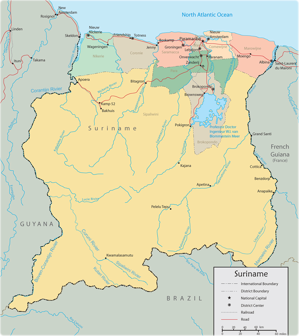
Coronie is a district of Suriname, situated on the coast. Coronie's capital city is Totness. The district border the Atlantic Ocean to the north, the Surinamese district of Saramacca to the east, the Surinamese district of Sipaliwini to the south and the Surinamese district of Nickerie to the west. The district is served by the Totness Airstrip. The district has a population of 3,391 and an area of 3,902 km2, and is the district with the smallest population. History The first plantations were established from 1808 onwards by English and Scottish colonists. Coronie became an independent district in 1851. The oldest plantation in the district is Burnside. Coronie was isolated and it was not until the 1940s, that a road was built linking Totness with Paramaribo, which is nowadays part of the East-West Link. In September 1965, four sounding rockets of Apache type with a maximum altitude of 205 km were launched. The rockets were launched as part as an investigation in ... [...More Info...] [...Related Items...] OR: [Wikipedia] [Google] [Baidu] |
Suriname
Suriname (; srn, Sranankondre or ), officially the Republic of Suriname ( nl, Republiek Suriname , srn, Ripolik fu Sranan), is a country on the northeastern Atlantic coast of South America. It is bordered by the Atlantic Ocean to the north, French Guiana to the east, Guyana to the west, and Brazil to the south. At just under , it is the smallest sovereign state in South America. It has a population of approximately , dominated by descendants from the slaves and labourers brought in from Africa and Asia by the Dutch Empire and Republic. Most of the people live by the country's (north) coast, in and around its capital and largest city, Paramaribo. It is also List of countries and dependencies by population density, one of the least densely populated countries on Earth. Situated slightly north of the equator, Suriname is a tropical country dominated by rainforests. Its extensive tree cover is vital to the country's efforts to Climate change in Suriname, mitigate climate ch ... [...More Info...] [...Related Items...] OR: [Wikipedia] [Google] [Baidu] |
Blue Wing Airlines
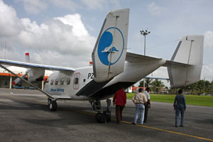
Blue Wing Airlines n.v. is an airline with its head office on the grounds of Zorg en Hoop Airport in Paramaribo, Suriname.Eight feared dead in Suriname air crash " ''''. 16 May 2010. Retrieved on 17 May 2010. The airline started operations in January 2002 and operates charter and scheduled services from to destinations in the interior of , |
Zorg En Hoop Airport
Zorg en Hoop Airport is an airport serving general aviation in the city of Paramaribo, Suriname. It is west of the Suriname River, between the city quarters of Zorg en Hoop and Flora. The runway length includes a displaced threshold on Runway 11. The airport is suitable for charters and regular services with smaller aircraft, and for helicopter flights. Connection is maintained from the airport for several smaller airports in the interior of Suriname, and for charter flights to the Caribbean. The only regular international service is to Georgetown, Guyana Georgetown is the capital (political), capital and largest city of Guyana. It is situated in Demerara-Mahaica, region 4, on the Atlantic Ocean coast, at the mouth of the Demerara River. It is nicknamed the "Garden City of the Caribbean." It is t ..., with flights operated by Trans Guyana Airways and Gum Air with smaller propeller aircraft. Airlines operating jet aircraft serve Paramaribo via Johan Adolf Pengel Internation ... [...More Info...] [...Related Items...] OR: [Wikipedia] [Google] [Baidu] |
Gum Air
Gum Air is a Surinamese airline based at Zorg en Hoop Airport in Paramaribo, Suriname. Gum Air cooperates with Trans Guyana Airways to provide daily flights between Zorg en Hoop Airport, Zorg en Hoop Airport (ORG) in Paramaribo, Suriname and Ogle Airport, Ogle Airport (OGL) in Georgetown, Guyana. History Gum Air was founded in 1971 by six brothers of the Gummels family. The company they started in March 1964 was agriculture airspray company named Surinam Sky Farmers and Gum Air its offspring focused more on domestic flights and regional charters. Whereas Surinam Sky Farmers has its base in the rice district of Nickerie District, Nickerie at the Wageningen Airstrip together with Overeem Air Service maintaining Grumman Ag Cat aircraft, Gum Air has set up its domestic airline at the Zorg en Hoop Airport in the city. Current operation Gum Air has its base at Zorg en Hoop airfield in the capital city Paramaribo and now mainly flies with single engine Cessna airplanes and twin-engin ... [...More Info...] [...Related Items...] OR: [Wikipedia] [Google] [Baidu] |
List Of Airports In Suriname
This is a list of airports in Suriname, sorted by location. Suriname, officially the Republic of Suriname, is a country in northern South America. It is situated between French Guiana to the east and Guyana to the west. The southern border is shared with Brazil and the northern border is the Atlantic coast. Suriname is the smallest sovereign state in terms of area and population in South America. The country is the only Dutch-speaking region in the Western Hemisphere that is not a part of the Kingdom of the Netherlands. __TOC__ Airports Airport names shown in bold indicate the airport has scheduled service on commercial airlines. Airports with unverified coordinates: Map See also * Transport in Suriname * Operation Grasshopper * List of airports by ICAO code: S#SM - Suriname * Wikipedia: WikiProject Aviation/Airline destination lists: South America#Suriname References Civil Aviation Department of Suriname* * - includes IATA codes World Aero Data: Airports ... [...More Info...] [...Related Items...] OR: [Wikipedia] [Google] [Baidu] |
Transport In Suriname
The Republic of Suriname ( nl, Republiek Suriname) has a number of forms of transport. Transportation emissions are an increasing part of Suriname's contributions to climate change, as part of the Nationally Determined Contributions for the Paris Agreement, Suriname has committed to emissions controls for vehicles and increased public transit investment. Railways *Railways, total: 166 km single track. **standard gauge: 80 km gauge in West-Suriname, but not in use. This stretch was constructed as part of the West Suriname Plan. **narrow gauge: 86 km gauge Lawa Railway from Onverwacht to Sarakreek, currently not in use. In 2014, a plan had been announced to reopen the line between Onverwacht and Paramaribo Central Station. The intention was for the line to be extended onto Paramaribo Adolf Pengel Airport, but as of May 2020, the project has not started. Rail links with adjacent countries * None Highways Afobakaweg The Afobakaweg is a paved 2-lane road connect ... [...More Info...] [...Related Items...] OR: [Wikipedia] [Google] [Baidu] |


.jpg)

.jpg)