|
Torontál County
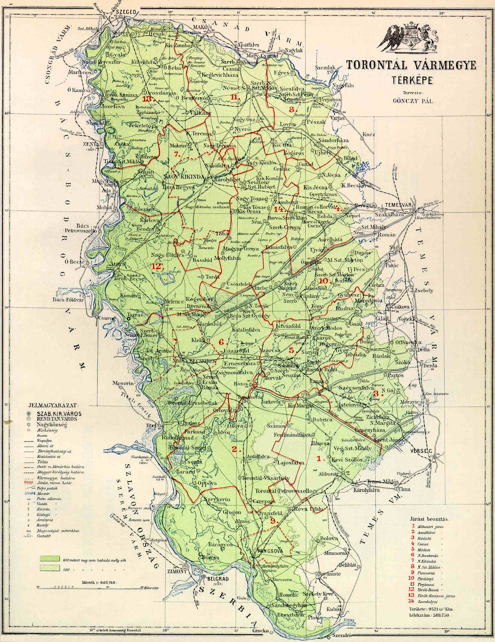
Torontál (, , , ) was an administrative county (comitatus) of the Kingdom of Hungary. Its territory is now divided between Serbia and Romania, except for a small area which is part of Hungary. The capital of the county was Nagybecskerek (, , ), the current Zrenjanin. Geography Torontál county was located in the Banat region. From its recreation in 1779 until its partition in 1920 it shared borders with the Hungarian counties of Bács-Bodrog, Csongrád, Csanád, Arad and Temes. The Banat Military Frontier lay along its southern border until it was abolished in 1873, after which the river Danube formed its southern border, which it shared with the Principality of Serbia (Kingdom of Serbia after 1882), and the Slavonian Military Frontier ( Croatian-Slavonian county of Syrmia after 1881). The river Tisza formed its western border and the river Maros (Mureș) its northern border. The rivers Aranca, Bega, Timiș and Bârzava flowed through the county. Its area was aro ... [...More Info...] [...Related Items...] OR: [Wikipedia] [Google] [Baidu] |
Comitatus (Kingdom Of Hungary)
Comitatus may refer to: *Comitatus (warband), a Germanic warband who follow a leader * ''Comitatus'', the office of a Roman or Frankish comes, translated as count. * ''Comitatus'', translated as county, a territory such as governed by medieval counts. * Comitatus (Kingdom of Hungary), counties in the Kingdom of Hungary * Comitatenses, armies of the late Roman Empire * Posse comitatus (other), various meanings See also * * Retinue, a body of persons "retained" in the service of a noble or royal person {{disambiguation ... [...More Info...] [...Related Items...] OR: [Wikipedia] [Google] [Baidu] |
Arad (Hungarian County)
Arad County was an administrative unit in the Kingdom of Hungary, the Eastern Hungarian Kingdom and the Principality of Transylvania. The county was established along the Maros (Mureș) River in the 11th or the , but its first head, or ''ispán'', was only mentioned in 1214. Its territory is now part of Romania, except a small area (the town of Elek and the surrounding villages) which is part of Hungary. The capital of the county was Arad. Geography The medieval Arad County was situated in the lands along both banks of the Maros (Mureș) River. The existence of arable lands, pastures, vineyards and orchards in the western lowlands in the Middle Ages is well-documented. The hilly eastern regions were sparsely populated. The total territory of the medieval county was around . In 1744, Arad County absorbed a large part of Zaránd County, including its capital Zaránd/ Zărand (the remainder of Zaránd County was then reorganized, with Körösbánya/ Baia de Criș as the n ... [...More Info...] [...Related Items...] OR: [Wikipedia] [Google] [Baidu] |
Timiș (river)
The Timiș or Tamiš (, , , ) is a river that flows through the Banat region of Romania and Serbia and joins the Danube near Pančevo, in northern Serbia. Due to its position in the region, it has been labeled as the "spine of the Banat". Name In Classical antiquity, antiquity, the river was known as ''Tibiscus'' (in Latin) and ''Tibisis'' (Θίβισις in ancient Greek), and as ''Timisis'' in De Administrando Imperio; in addition, Edward Gibbon referred to it as the ''Teyss''. ''The Romans, who traversed the plains of Hungary, suppose that they passed several navigable rivers, either in canoes or portable boats; but there is reason to suspect that the winding stream of the Teyss, or Tibiscus, might present itself in different places under different names.'' Geography The Drainage basin, drainage area covers , of which in Romania. With the Danube, the Timis belongs to the Black Sea drainage basin. The river flows through Romania for , and through Serbia. Its average di ... [...More Info...] [...Related Items...] OR: [Wikipedia] [Google] [Baidu] |
Bega (Tisza)
The Bega or Begej (; ; ; , formerly ''Kistemes''), is a 244 km (152 mile) long river in Romania (169 km; 105 mi.) and Serbia (75 km; 47 mi.). It rises in the Poiana Ruscă Mountains in Romania, part of the Carpathian Mountains, and it flows into the Tisza, Tisa river near Titel, Vojvodina, Serbia. Its drainage basin covers an area of ,Analysis of the Tisza River Basin 2007 International Commission for the Protection of the Danube River, IPCDR of which in Romania. Course Romania The river starts at the confluence of its headwaters, Bega Luncanilor and Bega Poienilor. After flowing north, the river bends to the west at Curtea, passing through Făget, Balinț, and Topolovățu Mare, where it enters the low Banat plain ...[...More Info...] [...Related Items...] OR: [Wikipedia] [Google] [Baidu] |
Aranca
The Aranca or Zlatica (Romanian: ''Aranca'', Serbian: Златица / ''Zlatica'', Hungarian: ''Aranka'') is a 117 km long river in the Banat region of Romania and Serbia, left tributary of the river Tisa. Hydronymy The Serbian and Hungarian names of the river carry the meaning the ''golden river''. Course The Aranca originates in the northern part of the Banat, near the village Sânpetru German, southwest of the city of Arad, Romania. e-calauza.ro It flows to the west, next to the large villages of , Saravale, the town of |
Mureș (river)
The Mureș () or Maros (; German: ''Mieresch'', ) is a river in Eastern Europe. Its drainage basin covers an area of .Analysis of the Tisza River Basin 2007 IPCDR It originates in the Hășmașu Mare Range in the Eastern Carpathian Mountains, , rising close to the headwa ... [...More Info...] [...Related Items...] OR: [Wikipedia] [Google] [Baidu] |
Tisza
The Tisza, Tysa or Tisa (see below) is one of the major rivers of Central and Eastern Europe. It was once called "the most Hungarian river" because it used to flow entirely within the Kingdom of Hungary. Today, it crosses several national borders. The Tisza begins near Rakhiv in Ukraine, at the confluence of the and , which is at coordinates (the former springs in the Chornohora mountains; the latter in the Gorgany range). From there, the Tisza flows west, roughly following Ukraine's borders with Romania and Hungary, then briefly as the border between Slovakia and Hungary, before entering into Hungary, and finally into Serbia. The Tisza enters Hungary at Tiszabecs, traversing the country from north to south. A few kilometers south of the Hungarian city of Szeged, it enters Serbia. Finally, it joins the Danube near the village of Stari Slankamen in Vojvodina, Serbia. The Tisza drains an area of about and has a length of Its mean annual discharge is seasonally to ... [...More Info...] [...Related Items...] OR: [Wikipedia] [Google] [Baidu] |
Syrmia (former County)
Syrmia County (, , , ) was a historic administrative subdivision (''županija'') of the Kingdom of Croatia-Slavonia. Croatia-Slavonia was an autonomous kingdom within the Lands of the Crown of Saint Stephen (Transleithania), the Hungarian part of Austria-Hungary. The region of Syrmia is today split between Croatia and Serbia. The capital of the county was Vukovar (). Geography Syrmia County shared borders with other Croatian-Slavonian counties of Požega and Virovitica, the Austro-Hungarian land of Bosnia and Herzegovina, the Kingdom of Serbia, and the Hungarian counties of Bács-Bodrog and Torontál. The County stretched along the right (southern) bank of the river Danube and the left (northern) bank of the river Sava, down to their confluence. Its area was 6,866 km² around 1910. Background By the 13th century, two counties were formed in this region: Syrmia (in the east) and Vukovar (in the west). Syrmia County was an administrative division of the Kingdom of Hung ... [...More Info...] [...Related Items...] OR: [Wikipedia] [Google] [Baidu] |
Kingdom Of Croatia-Slavonia
The Kingdom of Croatia-Slavonia (; or ; ) was a nominally autonomous kingdom and constitutionally defined separate political nation within the Austro-Hungarian Empire. It was created in 1868 by merging the kingdoms of Kingdom of Croatia (Habsburg), Croatia and Kingdom of Slavonia, Slavonia following the Croatian–Hungarian Settlement of 1868. It was associated with the Kingdom of Hungary within the dual Austro-Hungarian state, being within the Lands of the Crown of St. Stephen, also known as ''Transleithania''. While Croatia had been granted a wide internal autonomy with "national features", in reality, Croatian control over key issues such as tax and military issues was minimal and hampered by Hungary. It was internally officially referred to as the Triune Kingdom of Croatia, Slavonia and Dalmatia, also simply known as the Triune Kingdom, and had claims on Kingdom of Dalmatia, Dalmatia, which was administered separately by the Austrian Cisleithania. The city of Rijeka, follo ... [...More Info...] [...Related Items...] OR: [Wikipedia] [Google] [Baidu] |
Slavonian Military Frontier
The Slavonian Military Frontier ( or ; ; ; ) was a district of the Military Frontier, a territory in the Habsburg monarchy, first during the period of the Austrian Empire and then during the Austro-Hungarian Monarchy. It was formed out of territories the Habsburgs conquered from the Ottoman Empire and included southern parts of Slavonia and Syrmia; today the area it covered is mostly in eastern Croatia, with its easternmost parts in northern Serbia (mostly in Vojvodina region.) Divisions The Slavonian Military Frontier was divided between three regiments: Regiment N°VII, based at Vinkovci; Regiment N°VIII, based at Nova Gradiška and Regiment N°IX, based at Petrovaradin. Other important towns in the area included Sremski Karlovci, Stara Pazova, Zemun, and Sremska Mitrovica. History During the history, name Slavonian Military Frontier referred to different territories. It was first located in what is now Central Croatia and was known as the Varaždin generalat. It was ... [...More Info...] [...Related Items...] OR: [Wikipedia] [Google] [Baidu] |
Kingdom Of Serbia
The Kingdom of Serbia was a country located in the Balkans which was created when the ruler of the Principality of Serbia, Milan I of Serbia, Milan I, was proclaimed king in 1882. Since 1817, the Principality was ruled by the Obrenović dynasty (replaced by the Karađorđević dynasty for a short time). The Principality, under the suzerainty of the Ottoman Empire, ''de facto'' achieved full independence when the very last Ottoman troops left Belgrade in 1867. The Treaty of Berlin (1878), Congress of Berlin in 1878 recognized the formal independence of the Principality of Serbia, and in its composition Nišava District, Nišava, Pirot District, Pirot, Toplica District, Toplica and Vranje districts entered the Southern and Eastern Serbia, South part of Serbia. In 1882, Serbia was elevated to the status of a kingdom, maintaining a foreign policy friendly to Austria-Hungary. Between 1912 and 1913, Serbia greatly enlarged its territory through engagement in the First Balkan War, Fi ... [...More Info...] [...Related Items...] OR: [Wikipedia] [Google] [Baidu] |
Principality Of Serbia
The Principality of Serbia () was an autonomous, later sovereign state in the Balkans that came into existence as a result of the Serbian Revolution, which lasted between 1804 and 1817. Its creation was negotiated first through an unwritten agreement between Miloš Obrenović, leader of the Second Serbian Uprising, and Ottoman official Marashli Pasha. It was followed by the series of legal documents published by the Sublime Porte in 1828, 1829 and finally, 1830—the Hatt-i Sharif. Its ''de facto'' independence ensued in 1867, following the evacuation of the remaining Ottoman troops from the Belgrade Fortress and the country; its independence was recognized internationally in 1878 by the Treaty of Berlin. In 1882 the country was elevated to the status of kingdom. Background and establishment The Serbian revolutionary leaders—first Karađorđe and then Miloš Obrenović—succeeded in their goal of liberating Serbia from centuries-long Turkish rule. Turkish authoriti ... [...More Info...] [...Related Items...] OR: [Wikipedia] [Google] [Baidu] |


