|
Timahoe
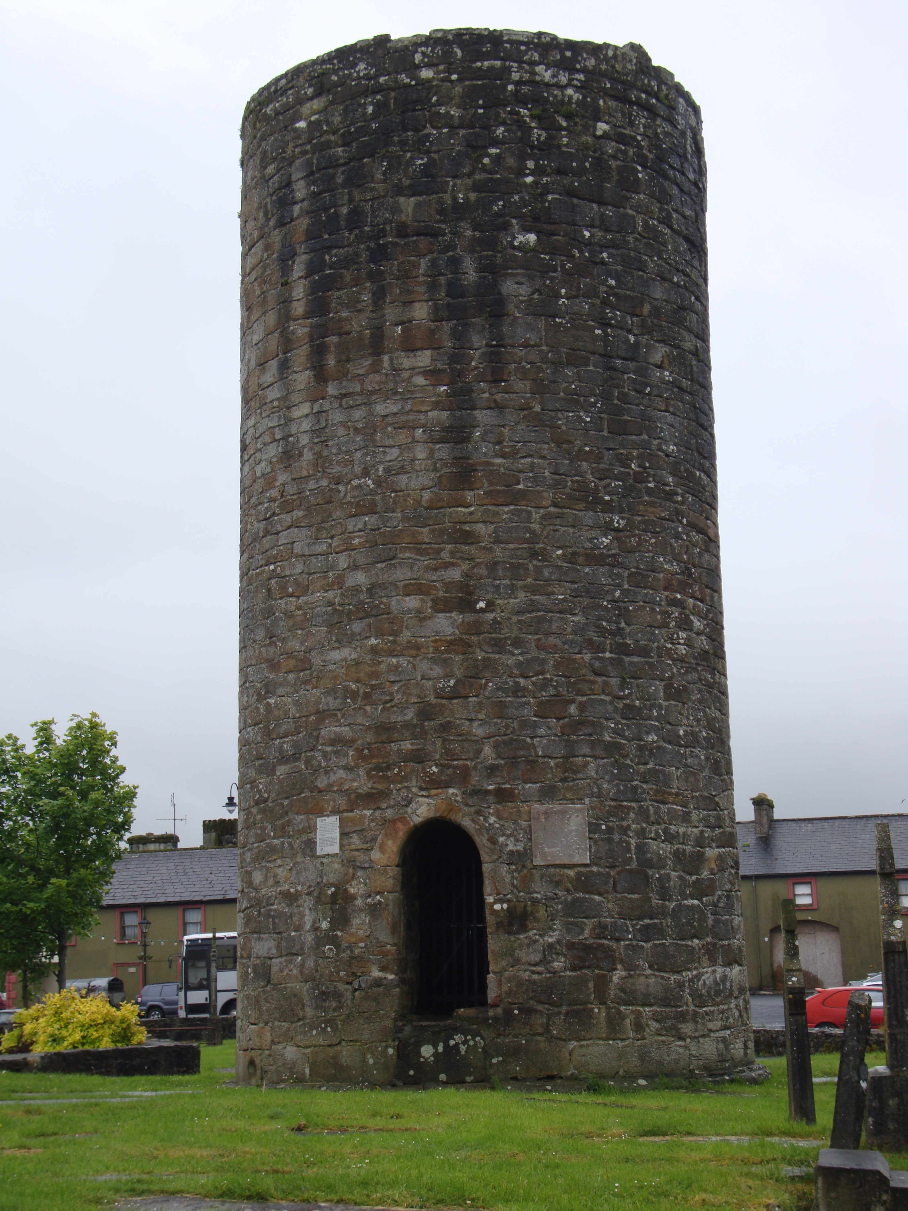
Timahoe (: 'House of Mochua') is a village in County Laois, Ireland, south of Portlaoise on the R426 regional road. The population of Timahoe in 2002 was 517, a 2.6% increase since 1996. It increased to 527 in 2006. Retrieved dead link with Wayback Machine, 14 October 2020 The 2021 population was recorded as 569. The population over the years has only very slightly increased. In 2008, a Timahoe Village Plan, to inform "any future developments which may occur within the development boundary of Timahoe", was drawn up to present to Laois County Council under the ''Laois County Development Plan 2006- 2012''. This plan looked at aspects such as land use zoning, social infrastructure, community facilities and physical infrastructure. The objective of the plan was to provide a development plan for the village to service the area over a 6-year period and to enhance the character of the village. History The village of Timahoe received its name from Saint Mochua who founded a monaste ... [...More Info...] [...Related Items...] OR: [Wikipedia] [Google] [Baidu] |
Timahoe Esker
Timahoe Esker is a national nature reserve of approximately located in County Laois, Ireland. It is managed by the Irish National Parks & Wildlife Service. Features Timahoe Esker was legally protected as a national nature reserve by the Irish government in 1985. It is also deemed to be a site of County Geological Significance by the Geological Survey of Ireland. Timahoe Esker, with Richmond Esker, is one of only a small number of esker ridges that remain in Ireland and that have native woodland. The area was planted with conifers in 1963. The woodland is made up of ash, pedunculate oak and grey willow with hazel and hawthorn. Other flora on the site include bugle, shield fern, and bluebells. Long-tailed tits nest on the site. Buckthorn, blue fleabane and carline thistle ''Carlina vulgaris'', the carline thistle, is a plant species of the genus '' Carlina''. It is a biennial that grows on limestone, chalky or other alkaline grasslands or dunes. The flowers are clusters of ... [...More Info...] [...Related Items...] OR: [Wikipedia] [Google] [Baidu] |
County Laois
County Laois ( ; gle, Contae Laoise) is a county in Ireland. It is part of the Eastern and Midland Region and in the province of Leinster. It was known as Queen's County from 1556 to 1922. The modern county takes its name from Loígis, a medieval kingdom. Historically, it has also been known as County Leix. Laois County Council is the local authority for the county. At the 2022 census, the population of the county was 91,657, an increase of 56% since the 2002 census. History Prehistoric The first people in Laois were bands of hunters and gatherers who passed through the county about 8,500 years ago. They hunted in the forests that covered Laois and fished in its rivers, gathering nuts and berries to supplement their diets. Next came Ireland's first farmers. These people of the Neolithic period (4000 to 2500 BC) cleared forests and planted crops. Their burial mounds remain in Clonaslee and Cuffsborough. Starting around 2500 BC, the people of the Bronze Age lived in Laois. Th ... [...More Info...] [...Related Items...] OR: [Wikipedia] [Google] [Baidu] |
Irish Round Tower
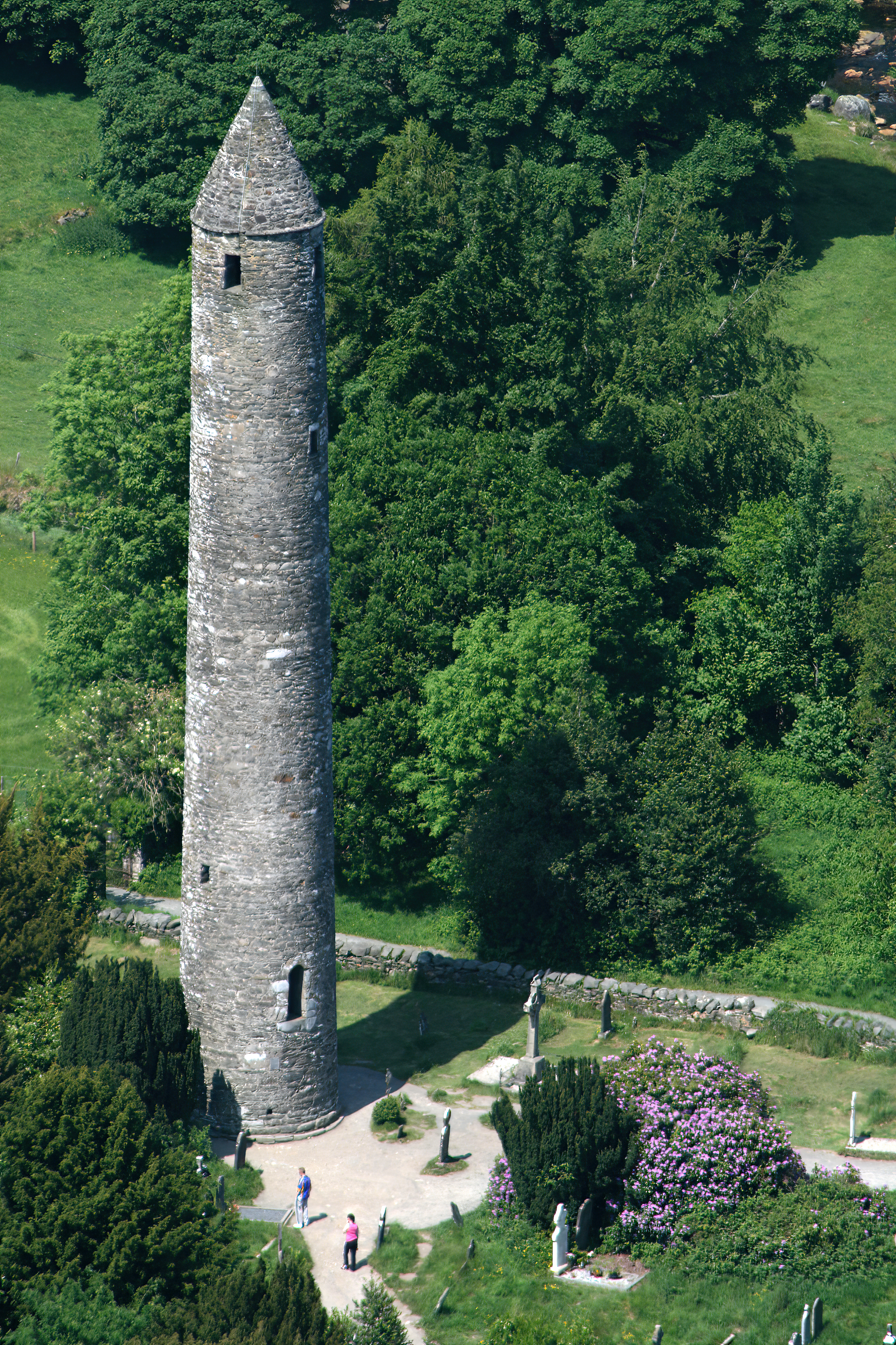
Irish round towers ( ga, Cloigtheach (singular), (plural); literally 'bell house') are early mediaeval stone towers of a type found mainly in Ireland, with two in Scotland and one on the Isle of Man. As their name indicates, they were originally bell towers, though they may have been later used for additional purposes. A tower of this kind is generally found in the vicinity of a church or monastery, with the door of the tower facing the west doorway of the church. Knowledge of this fact has made it possible, where towers still exist, to determine without excavation the approximate sites of lost churches that once stood nearby. Construction and distribution Surviving towers range in height from to , and to in circumference; that at Kilmacduagh being the highest surviving in Ireland (and leaning out of perpendicular). The masonry differs according to date, the earliest examples being uncut rubble, while the later ones are of neatly joined stonework (ashlar). The lower port ... [...More Info...] [...Related Items...] OR: [Wikipedia] [Google] [Baidu] |
Portlaoise
Portlaoise ( ), or Port Laoise (), is the county town of County Laois, Ireland. It is located in the Midland Region, Ireland, South Midlands in the province of Leinster. The 2016 census shows that the town's population increased by 9.5% to 22,050, which was well above the national average of 3.8%. It is the most populous and also the most densely populated town in the Midland Region, Ireland, Midland Region, which has a total population of 292,301 at the 2016 census. This also makes it the fastest growing of the top 20 largest towns and cities in Ireland. It was an important town in the medieval period, as the site of the Fort of Maryborough, a fort built by English settlers in the 16th century during the Plantations of Ireland#Early plantations (1556–1576), Plantation of Queen's County. Portlaoise is fringed by the Slieve Bloom Mountains, Slieve Bloom mountains to the west and north-west and the Great Heath of Maryborough to the east. It is notable for its architecture, engine ... [...More Info...] [...Related Items...] OR: [Wikipedia] [Google] [Baidu] |
List Of Sovereign States
The following is a list providing an overview of sovereign states around the world with information on their status and recognition of their sovereignty. The 206 listed states can be divided into three categories based on membership within the United Nations System: 193 UN member states, 2 UN General Assembly non-member observer states, and 11 other states. The ''sovereignty dispute'' column indicates states having undisputed sovereignty (188 states, of which there are 187 UN member states and 1 UN General Assembly non-member observer state), states having disputed sovereignty (16 states, of which there are 6 UN member states, 1 UN General Assembly non-member observer state, and 9 de facto states), and states having a special political status (2 states, both in free association with New Zealand). Compiling a list such as this can be a complicated and controversial process, as there is no definition that is binding on all the members of the community of nations concerni ... [...More Info...] [...Related Items...] OR: [Wikipedia] [Google] [Baidu] |
Cronan Mochua
Mo Chua or Crónán mac Bécáin, also called Claunus, Cuan, Mochua, Moncan and Moncain (died 30 March 637) was a legendary Irish saint who founded the monastery in Balla. Life Mo Chua was the youngest of the three sons of Becan (supposedly descended from Lugaid mac Con) and Cumne (daughter of Conamail of the Dál mBuinne). His hair fell out in patches, and he worked as a shepherd. Comgall of Bangor happening to visit Becan's house, and finding Mo Chua neglected by the family, took him with him to Bangor to educate him.Grattan-Flood, William. "Cronan." The Catholic Encyclopedia Vol. 4. New York: Robert Appleton Company, 1908. 29 July 2019 [...More Info...] [...Related Items...] OR: [Wikipedia] [Google] [Baidu] |
Hazel
The hazel (''Corylus'') is a genus of deciduous trees and large shrubs native to the temperate Northern Hemisphere. The genus is usually placed in the birch family Betulaceae,Germplasmgobills Information Network''Corylus''Rushforth, K. (1999). ''Trees of Britain and Europe''. Collins .Huxley, A., ed. (1992). ''New RHS Dictionary of Gardening''. Macmillan . though some botanists split the hazels (with the hornbeams and allied genera) into a separate family Corylaceae. The fruit of the hazel is the hazelnut. Hazels have simple, rounded leaves with double-serrate margins. The flowers are produced very early in spring before the leaves, and are monoecious, with single-sex catkins. The male catkins are pale yellow and long, and the female ones are very small and largely concealed in the buds, with only the bright-red, 1-to-3 mm-long styles visible. The fruits are nuts long and 1–2 cm diameter, surrounded by an involucre (husk) which partly to fully encloses the nut. ... [...More Info...] [...Related Items...] OR: [Wikipedia] [Google] [Baidu] |
Grey Willow
Grey willow or gray willow may refer to: *''Salix atrocinerea'', a species of willow native to Europe commonly called grey willow *''Salix cinerea'', a species of willow native to Europe and western Asia, also occasionally called grey sallow *''Salix glauca'', a species of willow native to northern North America, Europe and Asia {{Plant common name ... [...More Info...] [...Related Items...] OR: [Wikipedia] [Google] [Baidu] |
Esker
An esker, eskar, eschar, or os, sometimes called an ''asar'', ''osar'', or ''serpent kame'', is a long, winding ridge of stratified sand and gravel, examples of which occur in glaciated and formerly glaciated regions of Europe and North America. Eskers are frequently several kilometres long and, because of their uniform shape, look like railway embankments. Etymology The term ''esker'' is derived from the Irish word ''eiscir'' (Old Irish: ''escir''), which means "ridge or elevation, especially one separating two plains or depressed surfaces". The Irish word was and is used particularly to describe long sinuous ridges, which are now known to be deposits of fluvio-glacial material. The best-known example of such an ''eiscir'' is the '' Eiscir Riada'', which runs nearly the whole width of Ireland from Dublin to Galway, a distance of , and is still closely followed by the main Dublin-Galway road The synonym ''os'' comes from the Swedish word ''ås'', "ridge". Geology Most eske ... [...More Info...] [...Related Items...] OR: [Wikipedia] [Google] [Baidu] |
Capital (architecture)
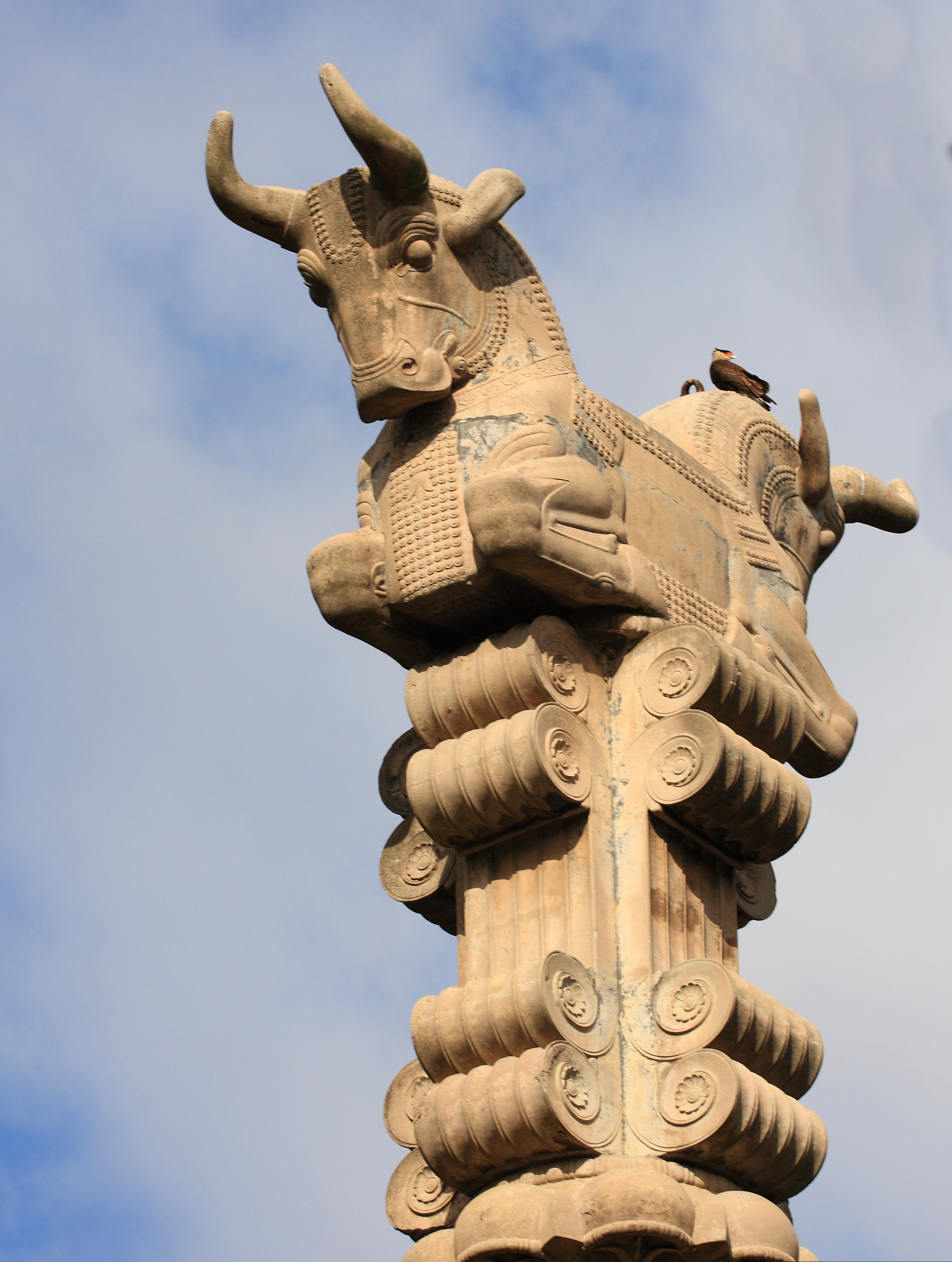
In architecture the capital (from the Latin ''caput'', or "head") or chapiter forms the topmost member of a column (or a pilaster). It mediates between the column and the load thrusting down upon it, broadening the area of the column's supporting surface. The capital, projecting on each side as it rises to support the abacus, joins the usually square abacus and the usually circular shaft of the column. The capital may be convex, as in the Doric order; concave, as in the inverted bell of the Corinthian order; or scrolling out, as in the Ionic order. These form the three principal types on which all capitals in the classical tradition are based. The Composite order established in the 16th century on a hint from the Arch of Titus, adds Ionic volutes to Corinthian acanthus leaves. From the highly visible position it occupies in all colonnaded monumental buildings, the capital is often selected for ornamentation; and is often the clearest indicator of the architectural orde ... [...More Info...] [...Related Items...] OR: [Wikipedia] [Google] [Baidu] |


