|
The Darian Dam Archaeological Salvage Program
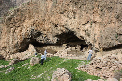
Darian Dam was constructed on the Sirwan River between 2009 and 2015. The Dam is located in the Hawrāmān region of Kurdistan and Kermanshah. The Darian Dam Archeological Salvage Program (DDASP) was planned by Iranian Center for Archaeological Research before flooding the reservoir. This archaeological program, under the general direction of Fereidoun Biglari, has conducted several seasons of archaeological surveys and excavations within the area of the reservoir that led to the discovery of a number of important Paleolithic and more later sites. The Main excavated sites were Darai Rockshelter (Middle Paleolithic), Kenacheh Cave (Upper Paleolithic), Ruwār tomb (Iron Age), Sar Cham (Chalcolithic and Iron Age), and Barda Mār (19th century). Except for Ruwar sites, all other excavated sites were flooded in 2015-2016. The results of these salvage excavations were presented at the First National Congress on Archaeology of Hawraman: Archaeological Salvage Excavations at the Darian Dam R ... [...More Info...] [...Related Items...] OR: [Wikipedia] [Google] [Baidu] |
Darian Dam
The Daryan Dam, also spelled Darian, is an embankment dam constructed on the Sirvan River just north of Daryan, Kermanshah, Daryan in Paveh County, Kermanshah Province, Iran. The primary purpose of the dam is to supply up to of water annually to the long Nowsud Water Conveyance Tunnel where it will irrigate areas of Southwestern Iran. The dam also has a 210 MW hydroelectric power station. Construction on the dam began in 2009 and the dam began to fill its reservoir in late November 2015. The Darian Dam Archaeological Salvage Program (DDASP) was planned by Iranian Center for Archaeological Research before flooding the reservoir. As a result a number of important archaeological sites were discovered and some were excavated. The power station was commissioned in 2018. The dam's diversion tunnel was completed in June 2011. The dam was designed by Stucky of France and consultation was provided by Mahab Ghodss, International Consulting Engineering Co. In August 2010 Farab Co. won the co ... [...More Info...] [...Related Items...] OR: [Wikipedia] [Google] [Baidu] |
Diyala River
The Diyala River (Arabic: ; ku, Sîrwan; Farsi: , ) is a river and tributary of the Tigris. It is formed by the confluence of Sirwan river and Tanjaro river in Darbandikhan Dam in the Sulaymaniyah Governorate of Northern Iraq. It covers a total distance of . Course It rises near Hamadan, in the Zagros Mountains of Iran. It then descends through the mountains, where for some 32 km it forms the border between the two countries. It finally feeds into the Tigris below Baghdad. Navigation of the upper reaches of the Diyala is not possible because of its narrow defiles, but the river's valley provides an important trade route between Iran and Iraq. The river flows southwest of the Hamrin Mountains. Name Its Aramaic origin is "Diyalas" and in Kurdish it is called "Sirwan", meaning 'roaring sea' or 'shouting river'. In early Islamic period, the lower course of the river formed part of the Nahrawan Canal. The Diyala Governorate in Iraq is named after the river. History The river ... [...More Info...] [...Related Items...] OR: [Wikipedia] [Google] [Baidu] |
Dams In Iran
A dam is a barrier that stops or restricts the flow of surface water or underground streams. Reservoirs created by dams not only suppress floods but also provide water for activities such as irrigation, human consumption, industrial use, aquaculture, and navigability. Hydropower is often used in conjunction with dams to generate electricity. A dam can also be used to collect or store water which can be evenly distributed between locations. Dams generally serve the primary purpose of retaining water, while other structures such as floodgates or levees (also known as dikes) are used to manage or prevent water flow into specific land regions. The earliest known dam is the Jawa Dam in Jordan, dating to 3,000 BC. The word ''dam'' can be traced back to Middle English, and before that, from Middle Dutch, as seen in the names of many old cities, such as Amsterdam and Rotterdam. History Ancient dams Early dam building took place in Mesopotamia and the Middle East. Dams were used ... [...More Info...] [...Related Items...] OR: [Wikipedia] [Google] [Baidu] |
Dams Completed In 2015
A dam is a barrier that stops or restricts the flow of surface water or underground streams. Reservoirs created by dams not only suppress floods but also provide water for activities such as irrigation, human consumption, industrial use, aquaculture, and navigability. Hydropower is often used in conjunction with dams to generate electricity. A dam can also be used to collect or store water which can be evenly distributed between locations. Dams generally serve the primary purpose of retaining water, while other structures such as floodgates or levees (also known as dikes) are used to manage or prevent water flow into specific land regions. The earliest known dam is the Jawa Dam in Jordan, dating to 3,000 BC. The word ''dam'' can be traced back to Middle English, and before that, from Middle Dutch, as seen in the names of many old cities, such as Amsterdam and Rotterdam. History Ancient dams Early dam building took place in Mesopotamia and the Middle East. Dams were us ... [...More Info...] [...Related Items...] OR: [Wikipedia] [Google] [Baidu] |
Geography Of Kurdistan
Kurdistan ( ku, کوردستان ,Kurdistan ; lit. "land of the Kurds") or Greater Kurdistan is a roughly defined geo-cultural territory in Western Asia wherein the Kurds form a prominent majority population and the Kurdish culture, languages, and national identity have historically been based. Geographically, Kurdistan roughly encompasses the northwestern Zagros and the eastern Taurus mountain ranges. Kurdistan generally comprises the following four regions: southeastern Turkey (Northern Kurdistan), northern Iraq (Southern Kurdistan), northwestern Iran (Eastern Kurdistan), and northern Syria (Western Kurdistan). Some definitions also include parts of southern Transcaucasia. Certain Kurdish nationalist organizations seek to create an independent nation state consisting of some or all of these areas with a Kurdish majority, while others campaign for greater autonomy within the existing national boundaries. Historically, the word "Kurdistan" is first attested in 11th century ... [...More Info...] [...Related Items...] OR: [Wikipedia] [Google] [Baidu] |
Geography Of Kurdistan Province
Geography (from Greek: , ''geographia''. Combination of Greek words ‘Geo’ (The Earth) and ‘Graphien’ (to describe), literally "earth description") is a field of science devoted to the study of the lands, features, inhabitants, and phenomena of Earth. The first recorded use of the word γεωγραφία was as a title of a book by Greek scholar Eratosthenes (276–194 BC). Geography is an all-encompassing discipline that seeks an understanding of Earth and its human and natural complexities—not merely where objects are, but also how they have changed and come to be. While geography is specific to Earth, many concepts can be applied more broadly to other celestial bodies in the field of planetary science. One such concept, the first law of geography, proposed by Waldo Tobler, is "everything is related to everything else, but near things are more related than distant things." Geography has been called "the world discipline" and "the bridge between the human and th ... [...More Info...] [...Related Items...] OR: [Wikipedia] [Google] [Baidu] |
Regions Of Iran
Iran has been divided into regions in a number of different ways historically. It has been divided into five administrative regions ( , singular ) since 2014. Current administrative regions Iran's thirty-one provinces were grouped into five regions on 22 June 2014, based on a decision by the Ministry of Interior. In this change, the adjacency, geographical location and similarities of the provinces were considered. The Constitution of Iran does not provide for regions and they are not the constituent units of the country but exist purely for the convenience of governmental administration. According to Javad Naserian, the Ministry of Interior's Management Development and Human Resources Vice-Minister, the purpose of this grouping of provinces was the creation of synergy, transfer of experience, information exchange, and regional development. Also, it now provides an intermediate level where provinces can discuss their problems among themselves, instead of going immediately to ... [...More Info...] [...Related Items...] OR: [Wikipedia] [Google] [Baidu] |
Darbandikhan Dam
The Darbandikhan Dam ( ku, Bendava Derbendîxanê ,بەنداوی دەربەندیخان) is a multi-purpose embankment dam on the Diyala River in northern Sulaymaniyah Governorate, Iraq. It was constructed between 1956 and 1961. The purpose of the dam is irrigation, flood control, hydroelectric power production and recreation. Due to poor construction and neglect, the dam and its 249 MW power station have undergone several repairs over the years. A rehabilitation of the power station began in 2007 and was completed in 2013. Background After the Harza Engineering Company of USA designed the dam, construction began in 1956. The reservoir began to fill in November 1961 and the dam was complete that same year. After the reservoir filled, several problems occurred. In 1967, there was a major slope failure about upstream of the dam. This and other slope failures are continually under repair. The bedrock beneath the dam has to be re-grouted and the crest of the dam settled too much, r ... [...More Info...] [...Related Items...] OR: [Wikipedia] [Google] [Baidu] |


