|
Talemzane Crater
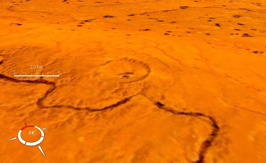
Talemzane or madena (tamazight:ⵜⴰⵍⴻⵎⵣⴰⵏ Arabic:تالمزان/مادنة) is an impact crater in Algeria, 40 km south-east of Hassi Delaa (a small city). One of four such craters in the country, Talemzane is classified as a simple crater. It has been designated by the 43rd Lunar and Planetary Science Conference to be a two-million- year-old, "true meteorite crater." Explored for the first time in 1928, studied in 1950 and 1988 by researchers from the universities of Oran (Algeria) and Nice (France). It is 1.75 km in diameter and the age is estimated to be less than three million years and is probably Pliocene. The name Maadna come from Arabic for "depression of ore." See also * List of impact craters in Africa References Further reading * Karpoff, R., A "meteorite" crater at Talemzane in southern Algeria, with discussion (in French). International Geological Congress, 19th, Algiers, pp. 233–241. 1954 * Karpoff, R., The meteorite c ... [...More Info...] [...Related Items...] OR: [Wikipedia] [Google] [Baidu] |
Landsat
The Landsat program is the longest-running enterprise for acquisition of satellite imagery of Earth. It is a joint NASA / USGS program. On 23 July 1972, the Earth Resources Technology Satellite was launched. This was eventually renamed to Landsat 1 in 1975. The most recent, Landsat 9, was launched on 27 September 2021. The instruments on the Landsat satellites have acquired millions of images. The images, archived in the United States and at Landsat receiving stations around the world, are a unique resource for global change research and applications in agriculture, cartography, geology, forestry, regional planning, surveillance and education, and can be viewed through the U.S. Geological Survey (USGS) "EarthExplorer" website. Landsat 7 data has eight spectral bands with spatial resolutions ranging from ; the temporal resolution is 16 days. Landsat images are usually divided into scenes for easy downloading. Each Landsat scene is about 115 miles long and 115 miles wide (or ... [...More Info...] [...Related Items...] OR: [Wikipedia] [Google] [Baidu] |
NASA World Wind
NASA WorldWind is an open-source (released under the NOSA license and the Apache 2.0 license) virtual globe. According to the website (https://worldwind.arc.nasa.gov/), "WorldWind is an open source virtual globe API. WorldWind allows developers to quickly and easily create interactive visualizations of 3D globe, map and geographical information. Organizations around the world use WorldWind to monitor weather patterns, visualize cities and terrain, track vehicle movement, analyze geospatial data and educate humanity about the Earth." It was first developed by NASA in 2003 for use on personal computers and then further developed in concert with the open source community since 2004. As of 2017, a web-based version of WorldWind is available online. An Android version is also available. The original version relied on .NET Framework, which ran only on Microsoft Windows. The more recent Java version, WorldWind Java, is cross platform, a software development kit (SDK) aime ... [...More Info...] [...Related Items...] OR: [Wikipedia] [Google] [Baidu] |
Sahara
, photo = Sahara real color.jpg , photo_caption = The Sahara taken by Apollo 17 astronauts, 1972 , map = , map_image = , location = , country = , country1 = , country2 = , country3 = , country4 = , country5 = , country6 = , country7 = , country8 = , country9 = , country10 = ( disputed) , region = , state = , district = , city = , relief = , label = , label_position = , coordinates = , coordinates_ref = , elevation = , elevation_m = , elevation_ft = , elevation_ref = , length = , length_mi = , length_km = 4,800 , length_orientation = , length_note = , width = , width_mi = , width ... [...More Info...] [...Related Items...] OR: [Wikipedia] [Google] [Baidu] |
Piacenzian
The Piacenzian is in the international geologic time scale the upper stage (stratigraphy), stage or latest age (geology), age of the Pliocene. It spans the time between 3.6 ± 0.005 year#SI prefix multipliers, Ma and 2.588 ± 0.005 Ma (million years ago). The Piacenzian is after the Zanclean and is followed by the Gelasian (part of the Pleistocene). The Piacenzian is roughly coeval with the European land mammal age MN 16, overlaps the late Chapadmalalan and early Uquian South American land mammal age and falls inside the more extensive Blancan North American land mammal age. It also correlates with the Astian, Redonian, Reuverian and Romanian regional stages of Europe. Some authorities describe the British Red Crag Formation and Waltonian Stage as late Piacenzian, while others regard them as early Pleistocene. Carbon dioxide levels during the Piacenzian were similar to those of today, making this age, with global mean temperature 2–3 °C higher and sea levels about twenty meters ... [...More Info...] [...Related Items...] OR: [Wikipedia] [Google] [Baidu] |
Algeria
) , image_map = Algeria (centered orthographic projection).svg , map_caption = , image_map2 = , capital = Algiers , coordinates = , largest_city = capital , religion = , official_languages = , languages_type = Other languages , languages = Algerian Arabic (Darja) French , ethnic_groups = , demonym = Algerian , government_type = Unitary semi-presidential republic , leader_title1 = President , leader_name1 = Abdelmadjid Tebboune , leader_title2 = Prime Minister , leader_name2 = Aymen Benabderrahmane , leader_title3 = Council President , leader_name3 = Salah Goudjil , leader_title4 = Assembly President , leader_name4 = Ibrahim Boughali , legislature = Parliament , upper_house = Council of the Nation , lower_house ... [...More Info...] [...Related Items...] OR: [Wikipedia] [Google] [Baidu] |
Laghouat Province
Laghouat ( ar, ولاية الأغواط) is one of the forty-eight provinces (''wilaya'') of Algeria. It is located in the north central part of Algeria. The province borders Tiaret Province to the north, El Bayadh Province to the west, Ghardaia Province to the south and Djelfa Province to the east. The capital of the province is Laghouat City. The province is famous for palm trees and livestock. The province is a large producer of natural gas, containing important drilling sites in the region of Hassi R'Mel. Large reserves of natural gas have allowed Algeria to occupy an important position in the global energy market. Geography Location and Nature Located at an average altitude of 750 m above sea level, Laghouat Province is part of the Saharan Atlas Mountain range with some peaks rising above 2,000 m. For example, the Djebel Amour range reaches a top height of about 2,200 m. Laghouat is nearly 400 km away from Algiers, the capital of Algeria. The area's orchards, ... [...More Info...] [...Related Items...] OR: [Wikipedia] [Google] [Baidu] |
Tamazight
The Berber languages, also known as the Amazigh languages or Tamazight,, ber, label=Tuareg Tifinagh, ⵜⵎⵣⵗⵜ, ) are a branch of the Afroasiatic language family. They comprise a group of closely related languages spoken by Berber communities, who are indigenous to North Africa.Hayward, Richard J., chapter ''Afroasiatic'' in Heine, Bernd & Nurse, Derek, editors, ''African Languages: An Introduction'' Cambridge 2000. . The languages were traditionally written with the ancient Libyco-Berber script, which now exists in the form of Tifinagh. Today, they may also be written in the Berber Latin alphabet or the Arabic script, with Latin being the most pervasive. Berber languages are spoken by large populations of Morocco, Algeria and Libya, by smaller populations of Tunisia, northern Mali, western and northern Niger, northern Burkina Faso and Mauritania and in the Siwa Oasis of Egypt. Large Berber-speaking migrant communities, today numbering about 4 million, have been living ... [...More Info...] [...Related Items...] OR: [Wikipedia] [Google] [Baidu] |
Arabic
Arabic (, ' ; , ' or ) is a Semitic languages, Semitic language spoken primarily across the Arab world.Semitic languages: an international handbook / edited by Stefan Weninger; in collaboration with Geoffrey Khan, Michael P. Streck, Janet C. E.Watson; Walter de Gruyter GmbH & Co. KG, Berlin/Boston, 2011. Having emerged in the 1st century, it is named after the Arabs, Arab people; the term "Arab" was initially used to describe those living in the Arabian Peninsula, as perceived by geographers from ancient Greece. Since the 7th century, Arabic has been characterized by diglossia, with an opposition between a standard Prestige (sociolinguistics), prestige language—i.e., Literary Arabic: Modern Standard Arabic (MSA) or Classical Arabic—and diverse vernacular varieties, which serve as First language, mother tongues. Colloquial dialects vary significantly from MSA, impeding mutual intelligibility. MSA is only acquired through formal education and is not spoken natively. It is ... [...More Info...] [...Related Items...] OR: [Wikipedia] [Google] [Baidu] |
Impact Crater
An impact crater is a circular depression in the surface of a solid astronomical object formed by the hypervelocity impact of a smaller object. In contrast to volcanic craters, which result from explosion or internal collapse, impact craters typically have raised rims and floors that are lower in elevation than the surrounding terrain. Lunar impact craters range from microscopic craters on lunar rocks returned by the Apollo Program and small, simple, bowl-shaped depressions in the lunar regolith to large, complex, multi-ringed impact basins. Meteor Crater is a well-known example of a small impact crater on Earth. Impact craters are the dominant geographic features on many solid Solar System objects including the Moon, Mercury, Callisto, Ganymede and most small moons and asteroids. On other planets and moons that experience more active surface geological processes, such as Earth, Venus, Europa, Io and Titan, visible impact craters are less common because they become eroded ... [...More Info...] [...Related Items...] OR: [Wikipedia] [Google] [Baidu] |
Hassi Delaa
Hassi Delaa is a town and commune in Laghouat Province, Algeria ) , image_map = Algeria (centered orthographic projection).svg , map_caption = , image_map2 = , capital = Algiers , coordinates = , largest_city = capital , relig .... According to the 1998 census, it has a population of 6,930. References Communes of Laghouat Province Laghouat Province {{Laghouat-geo-stub ... [...More Info...] [...Related Items...] OR: [Wikipedia] [Google] [Baidu] |
Pliocene
The Pliocene ( ; also Pleiocene) is the epoch in the geologic time scale that extends from 5.333 million to 2.58See the 2014 version of the ICS geologic time scale million years ago. It is the second and most recent epoch of the Neogene Period in the . The Pliocene follows the Epoch and is followed by the Epoch. Prior to the 2009 ... [...More Info...] [...Related Items...] OR: [Wikipedia] [Google] [Baidu] |


