|
Tabaung
Tabaung ( my, တပေါင်း) is the twelfth and final month of the traditional Burmese calendar. Festivals and observances *Tabaung Festival (Magha Puja) - full moon of Tabaung * Sand Pagoda Festival () *28 Pagoda Parade Festival, Pyinmana Township *Pagoda festivals **Shwedagon Pagoda Festival **Alaungdaw Kathapa Pagoda Festival, Sagaing Region **Shwesettaw Pagoda Festival, Minbu Township, Magwe Region **Shwesayan Pagoda Festival ( Patheingyi Township, Mandalay Region) Tabaung symbols *Flower: '' Calophyllum amoenum'' References See also *Burmese calendar *Festivals of Burma Burmese traditional festivals are based on the traditional Burmese calendar and dates are largely determined by the moon's phase. Burmese culture is most evident in villages where local festivals are held throughout the year, the most importan ... {{Burmese months Months of the Burmese calendar ... [...More Info...] [...Related Items...] OR: [Wikipedia] [Google] [Baidu] |
Pagoda Festival
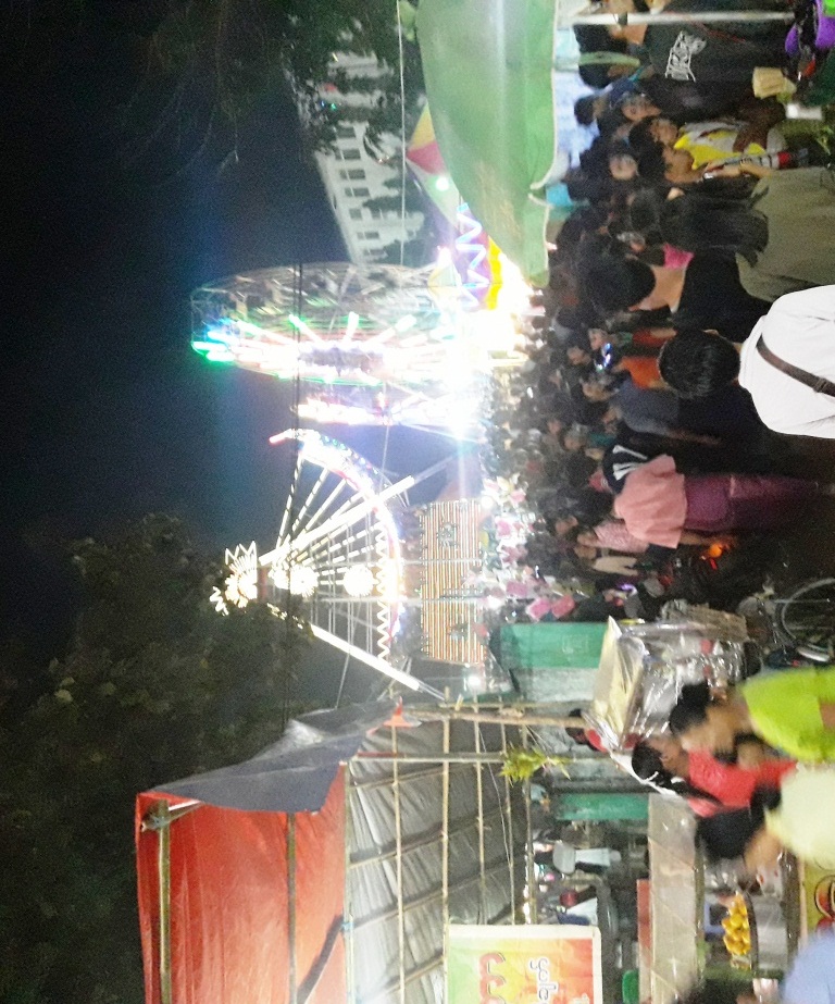
Pagoda festivals ( my, ဘုရားပွဲ; ''paya pwe'') are regular festivals found throughout Burma (Myanmar) that commemorate major religious events in pagoda's history, including the founding of a pagoda and the crowning of the pagoda's hti (umbrella). Pagoda festivals are dictated by the Burmese religious calendar and often are held several days at a time. Major events in a pagoda festival typically do not coincide with Uposatha (Buddhist Sabbath) days, during which pious Buddhists observe the Eight Precepts. The majority of pagoda festivals are held during the dry season, from the months of Tazaungmon (November) to Tabaung (March). During the full moon day of Tabaung (Magha Puja), Buddhist devotees in various parts of Myanmar also celebrate sand pagoda festivals. More well-known pagoda festivals often attract numerous pilgrims from throughout the country. Pagoda festivals are similar in nature to agricultural shows (country fairs) or carnivals, and form a signifi ... [...More Info...] [...Related Items...] OR: [Wikipedia] [Google] [Baidu] |
Burmese Calendar
The Burmese calendar ( my, မြန်မာသက္ကရာဇ်, , or , ; Burmese Era (BE) or Myanmar Era (ME)) is a lunisolar calendar in which the months are based on lunar months and years are based on sidereal years. The calendar is largely based on an older version of the Hindu calendar, though unlike the Indian systems, it employs a version of the Metonic cycle. The calendar therefore has to reconcile the sidereal years of the Hindu calendar with the Metonic cycle's near tropical years by adding intercalary months and days at ''irregular'' intervals. The calendar has been used continuously in various Burmese states since its purported launch in 640 CE in the Sri Ksetra Kingdom, also called the ''Pyu era''. It was also used as the official calendar in other mainland Southeast Asian kingdoms of Arakan, Lan Na, Xishuangbanna, Lan Xang, Siam, and Cambodia down to the late 19th century. Today, the calendar is used in Myanmar as one of the two official calendars alo ... [...More Info...] [...Related Items...] OR: [Wikipedia] [Google] [Baidu] |
Sand Pagoda
Sand pagodas ( my, သဲပုံစေတီ; th, พระเจดีย์ทราย, also known as sand stupas), are temporary pagodas or stupas erected from mud or sand as a means of cultivating Buddhist merit. The practice is common to Theravada Buddhists throughout mainland Southeast Asia, primarily in Myanmar (Burma) and Thailand. History The earliest extant reference to the sand pagoda building tradition is in Burmese literary works, namely a ''pyo'' verse poem composed by Shin Maha Silavamsa during the Kingdom of Ava (c. 1500s). By contrast, Burmese oral tradition attributes the custom of building sand pagodas to the arrival of Ayutthayan royals, advisors and their retinue in the Konbaung Kingdom, which occurred two centuries later, following the fall of Ayutthaya in the Burmese–Siamese War (1765–1767). The custom was practiced throughout the kingdom in pre-colonial Burma, including by the royal court. Regional celebrations Myanmar During Māgha Pūjā ... [...More Info...] [...Related Items...] OR: [Wikipedia] [Google] [Baidu] |
Shwedagon Pagoda
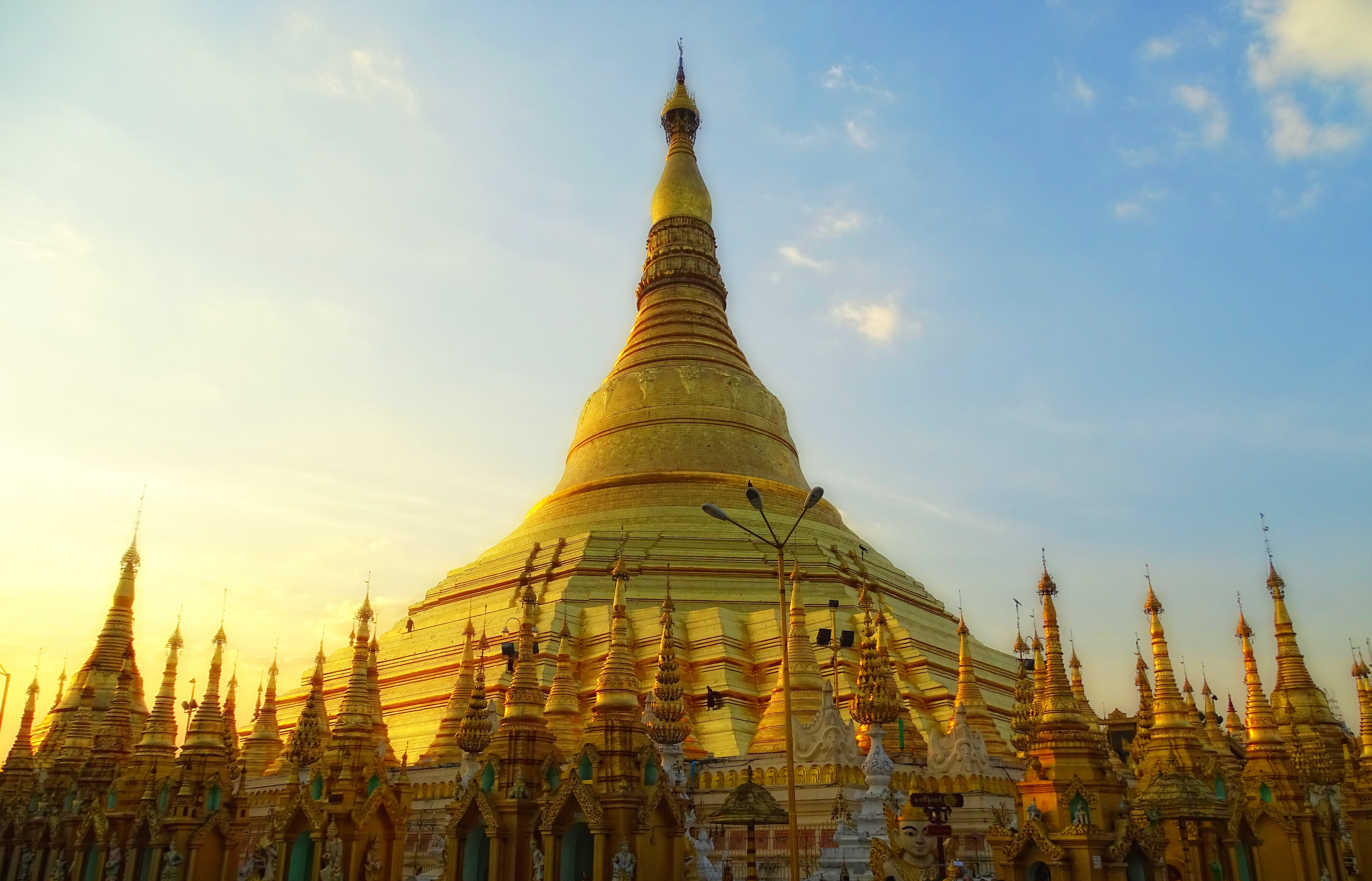
The Shwedagon Pagoda (, ); mnw, ကျာ်ဒဂုၚ်; officially named ''Shwedagon Zedi Daw'' ( my, ရွှေတိဂုံစေတီတော်, , ) and also known as the Great Dagon Pagoda and the Golden Pagoda is a gilded stupa located in Yangon, Myanmar. The Shwedagon is the most sacred Buddhist pagoda in Myanmar, as it is believed to contain relics of the four previous Buddhas of the present kalpa. These relics include the staff of Kakusandha, the water filter of Koṇāgamana, a piece of the robe of Kassapa, and eight strands of hair from the head of Gautama. Built on the high Singuttara Hill, the tall pagoda stands above sea level,The pagoda's pinnacle height (to the tip of its ''hti'') is tall per (UNESCO 2018), and is built on the Singuttara Hill, which is tall per , and tall above sea level per and dominates the Yangon skyline. Yangon's zoning regulations, which cap the maximum height of buildings to above sea level (75% of the pagoda's sea ... [...More Info...] [...Related Items...] OR: [Wikipedia] [Google] [Baidu] |
Festivals Of Burma ...
Burmese traditional festivals are based on the traditional Burmese calendar and dates are largely determined by the moon's phase. Burmese culture is most evident in villages where local festivals are held throughout the year, the most important being the pagoda festival. Festivals References {{Burma (Myanmar) topics Burmese culture Burma Myanmar, ; UK pronunciations: US pronunciations incl. . Note: Wikipedia's IPA conventions require indicating /r/ even in British English although only some British English speakers pronounce r at the end of syllables. As John Wells explai ... [...More Info...] [...Related Items...] OR: [Wikipedia] [Google] [Baidu] |
Magha Puja
{{disambig ...
Magha (māgha, माघ or maghā, मघा) may refer to: * Magha (month) (māgha, माघ), a month in the Hindu calendar * Magh (Bengali calendar), the same month in the Bengali calendar * Magha (poet) (māgha, माघ), an 8th-century Sanskrit poet, who wrote Shishupala-vadha * Magha (nakshatra) (maghā, मघा), a nakshatra (star or division of the sky) in Indian astronomy or astrology * Magha Puja (Māgha Pūjā), a Southeast Asian Buddhist festival * Kalinga Magha a king of Sri Lanka See also * Maga (other) * Maghar (other) * Megha (other) Megha means "cloud" in several Indian languages, comes from the Sanskrit word मेघ (megha, "cloud"). It may refer to: Films * ''Megha'' (1996 film), hi, मेघा, an Indian Hindi-language film. * ''Megha'' (2014 film), ta, மேக� ... [...More Info...] [...Related Items...] OR: [Wikipedia] [Google] [Baidu] |
Pyinmana Township
Pyinmana Township ( my, ပျဉ်းမနားမြို့နယ်) is one of eight townships of Naypyidaw Union Territory, Myanmar. History Historically, Pyinmana was formerly known as Ningyan (နင်းကြမ်း). Shan traders who observed the abundance of Terminalia chebula trees around the area named the city Pangmaakna (ပၢင်မၢၵ်ႇၼႃႉ), lit. "myrobalan encampment," from which the Burmese language name Pyinmana is derived. Pyinmana Township was formerly part of Mandalay Division. The township was designated as one of the original townships constituting the new capital region of Naypyidaw on 26 November 2008 by the Ministry of Home Affairs (MOHA). Demographics 2014 The 2014 Myanmar Census reported that Pyinmana Township had a population of 187,565. The population density was 170.1 people per km². The census reported that the median age was 26.6 years, and 94 males per 100 females. There were 39,663 households; the mean household size ... [...More Info...] [...Related Items...] OR: [Wikipedia] [Google] [Baidu] |
Sagaing Region
Sagaing Region ( my, စစ်ကိုင်းတိုင်းဒေသကြီး, ; formerly Sagaing Division) is an administrative region of Myanmar, located in the north-western part of the country between latitude 21° 30' north and longitude 94° 97' east. It is bordered by India's Nagaland, Manipur, and Arunachal Pradesh States to the north, Kachin State, Shan State, and Mandalay Region to the east, Mandalay Region and Magway Region to the south, with the Ayeyarwady River forming a greater part of its eastern and also southern boundary, and Chin State and India to the west. The region has an area of . In 1996, it had a population of over 5,300,000 while its population in 2012 was 6,600,000. The urban population in 2012 was 1,230,000 and the rural population was 5,360,000. The capital city of Sagaing Region is Monywa. Capital city The Capital city of Sagaing Region is Monywa. History The Pyu were the first to in recorded history to populate the area of Sagaing Regio ... [...More Info...] [...Related Items...] OR: [Wikipedia] [Google] [Baidu] |
Minbu Township
Minbu Township ( my, မင်းဘူး မြို့နယ်) is a township of Minbu District in the Magway Region of Myanmar. The principal town is Minbu. The township is home to the Shwe Settaw Pagoda, which holds an annual pagoda festival from the fifth waning day of Tabodwe Tabodwe ( my, တပို့တွဲ) is the eleventh month of the traditional Burmese calendar. Festivals and observances *Full moon of Tabodwe **Harvest Festival () **Mon National Day Rakhine tug of war festival, Yatha Hswe Pwe. *Pagoda fes ... to the Burmese New Year, attracting 100,000 pilgrims nationwide. Townships of Magway Region {{Magway-geo-stub ... [...More Info...] [...Related Items...] OR: [Wikipedia] [Google] [Baidu] |
Magwe Region
Magway Region ( my, မကွေးတိုင်းဒေသကြီး, ; formerly Magway Division) is an administrative division in central Myanmar. It is the second largest of Myanmar's seven divisions, with an area of . Pa Del Dam (ပဒဲဆည်) is one of the dams in Aunglan Township, Magway Division. The capital and second largest city of the Magway Division is Magway. The largest city is Pakokku. The major cities of Magway Division are Magway, Pakokku, Aunglan, Yenangyaung, Taungdwingyi, Chauk, Minbu, Thayet and Gangaw. Geography Magway Region sits approximately between north latitude 18° 50' to 22° 47' and east longitude 93° 47' to 95° 55'. It is bordered by Sagaing Region to the north, Mandalay Region to the east, Bago Region to the south, and Rakhine State and Chin State to the west. History Fossils of the early primates over 40 million years old were excavated in the Pondaung and Ponnya areas from Pakokku District in Magway Region, leading the governm ... [...More Info...] [...Related Items...] OR: [Wikipedia] [Google] [Baidu] |
Patheingyi Township
Patheingyi Township ( my, ပုသိမ်ကြီးမြို့နယ်, ) is located in the eastern part of Mandalay, Myanmar. The township is bounded by Aungmyethazan Township and Chanayethazan Township in the west. Incorporated into the Mandalay city's limits, Patheingyi represents the eastward march of Mandalay's urban sprawl. Patheingyi is still largely made up of rice paddy fields but in the past two decades has become home to a number of universities. Notable places * Mandalay Tuberculosis Hospital * Mandalay Technological University * University of Computer Studies, Mandalay * University of Culture, Mandalay * University of Medical Technology, Mandalay * University of Paramedical Science, Mandalay The University of Medical Technology, Mandalay ( my, ဆေးဘက်ဆိုင်ရာ နည်းပညာ တက္ကသိုလ် (မန္တလေး), ; formerly, the Institute of Paramedical Science, Mandalay), located in Pat ... * Upper Myan ... [...More Info...] [...Related Items...] OR: [Wikipedia] [Google] [Baidu] |
Mandalay Region
Mandalay Region ( my, မန္တလေးတိုင်းဒေသကြီး, ; formerly Mandalay Division) is an administrative divisions of Myanmar, administrative division of Myanmar. It is located in the center of the country, bordering Sagaing Region and Magway Region to the west, Shan State to the east, and Bago Region and Kayin State to the south. The regional capital is Mandalay. To the south of the region lies the national capital of Naypyidaw. The division consists of eleven districts, which are subdivided into 28 townships and 2,320 wards and village-tracts. Mandalay Region is important in Economy of Myanmar, Myanmar's economy, accounting for 15% of the national economy. It is under the administration of the Mandalay Region Government. History The history of Mandalay Region is the same as that of much of Upper Myanmar except that for much of Burmese history, the political power emanated out of royal capitals located in Mandalay Region. The country's present capit ... [...More Info...] [...Related Items...] OR: [Wikipedia] [Google] [Baidu] |


