|
Strijen
Strijen () is a town and former municipality in the western Netherlands, in the province of South Holland. The municipality, covering an area of of which is water, is located on the Hoeksche Waard island along the Hollands Diep estuary. On 1 January 2019 it was merged with the municipalities of Binnenmaas, Cromstrijen, Korendijk, and Oud-Beijerland to form the municipality of Hoeksche Waard. Strijen hosts a public library, swimming pool, a small shopping centre and a local museum. Furthermore, Strijen is home to an important and welcome resting stop for migrating birds, especially geese. During winter, the endangered Eurasian spoonbill uses this area as a foraging ground. The municipality of Strijen also includes the population centres of Cillaarshoek, De Klem, Mookhoek Mookhoek is a village in the Dutch province of South Holland and is part of the municipality of Hoeksche Waard The Hoekse Waard (; pre-1947 spelling: Hoeksche Waard) is an island between the Oude ... [...More Info...] [...Related Items...] OR: [Wikipedia] [Google] [Baidu] |
Strijen 1867
Strijen () is a town and former municipality in the western Netherlands, in the province of South Holland. The municipality, covering an area of of which is water, is located on the Hoeksche Waard island along the Hollands Diep estuary. On 1 January 2019 it was merged with the municipalities of Binnenmaas, Cromstrijen, Korendijk, and Oud-Beijerland to form the municipality of Hoeksche Waard (municipality), Hoeksche Waard. Strijen hosts a public library, swimming pool, a small shopping centre and a local museum. Furthermore, Strijen is home to an important and welcome resting stop for migrating birds, especially geese. During winter, the endangered Eurasian spoonbill uses this area as a foraging ground. The municipality of Strijen also includes the population centres of Cillaarshoek, De Klem, Mookhoek, Oudendijk (Strijen), Oudendijk, and Strijensas. Notable people *Anton Corbijn (born 1955), photographer, music video director and film director. References External links ... [...More Info...] [...Related Items...] OR: [Wikipedia] [Google] [Baidu] |
Strijensas
Strijensas is a village in the Dutch province of South Holland. It is located about 12 km southwest of the city of Dordrecht, in the municipality of Hoeksche Waard. The village was first mentioned in 1617 as "'t Sas van Stryen", and means "the sluice of Strijen". Strijensas developed after 1650 at the mouth of the harbour canal of Strijen. The first Dutch Reformed church was built in 1879. In February 1945, it was destroyed by war and replace in 1952. Strijensas was home to 301 people in 1840. Nowadays, it consists of about 180 houses. It was a separate municipality between 1817 and 1855, when it became part of Strijen. In 2019, it became part of the municipality of Hoeksche Waard The Hoekse Waard (; pre-1947 spelling: Hoeksche Waard) is an island between the Oude Maas, Dordtsche Kil, Hollands Diep, Haringvliet and Spui rivers in the province of South Holland in the Netherlands. The island, part of the namesake municipal .... References External links Strijensas Info ... [...More Info...] [...Related Items...] OR: [Wikipedia] [Google] [Baidu] |
Hoeksche Waard (municipality)
Hoeksche Waard () is a municipality in the western Netherlands, in the province of South Holland, consisting of the eponymous Hoeksche Waard and Tiengemeten islands. The municipality was formed on 1 January 2019 by the merger of the municipalities Binnenmaas, Cromstrijen, Korendijk, Oud-Beijerland, and Strijen. Gallery File:'s-Gravendeel, de Kerk op de Heul GM1963-WN13 IMG 0979 2021-09-06 17.30.jpg, 's-Gravendeel, church: the Kerk op de Heul File:'s-Gravendeel, korenmolen het Vliegend Hert RM17406 foto3 2014-04-14 17.10.jpg, 's-Gravendeel, windmill: korenmolen het Vliegend Hert File:Westmaas, de Nederlands Hervormde kerk RM38856 IMG 0929 2021-09-06 13.38.jpg, Westmaas, reformed church File:Klaaswaal, de Nederlands Hervormde kerk RM23662 IMG 0941 2021-09-06 14.04.jpg, Klaaswaal, reformed church File:Strijen, de Grote- of Sint Lambertuskerk RM34945 IMG 0960 2021-09-06 16.04.jpg, Strijen, church: the Grote- or Sint Lambertuskerk File:Maasdam, de Kerk GM1963-WN24 IMG 0978 2021 ... [...More Info...] [...Related Items...] OR: [Wikipedia] [Google] [Baidu] |
Anton Corbijn
Anton Johannes Gerrit Corbijn van Willenswaard (; born 20 May 1955) is a Dutch photographer, film director and music video director. He is the creative director behind the visual output of Depeche Mode and U2,Pitman, Joanna"The silent partner"''The Times'', 14 February 2005. Retrieved 9 July 2009Mackintosh, Hamish"Talk Time: Anton Corbijn"''The Guardian'', 31 March 2005. Retrieved 9 July 2009 having handled the principal promotion and sleeve photography for both bands over three decades. Some of his works include music videos for Depeche Mode's "Enjoy the Silence" (1990), U2's " One" (version 1) (1991), Bryan Adams' "Do I Have to Say the Words?", Nirvana's "Heart-Shaped Box" (1993) and Coldplay’s "Talk" (2005) and "Viva la Vida" (2008), as well as the Ian Curtis biographical film ''Control'' (2007),Zacharek, Stephanie"Closer to Joy"''Salon'', 10 October 2007. Retrieved 9 July 2009 '' The American'' (2010), '' A Most Wanted Man'' (2014), based on John le Carré's 2008 novel of ... [...More Info...] [...Related Items...] OR: [Wikipedia] [Google] [Baidu] |
Hoeksche Waard
The Hoekse Waard (; pre-1947 spelling: Hoeksche Waard) is an island between the Oude Maas, Dordtsche Kil, Hollands Diep, Haringvliet and Spui rivers in the province of South Holland in the Netherlands. The island, part of the namesake municipality of Hoeksche Waard, is a mostly agricultural region, south of the outskirts of Rotterdam. The Hoeksche Waard consists of reclaimed land (polders): after the Saint Elisabeth flood of 1421 most of the area was flooded. The land has been reclaimed gradually in the following centuries. Former municipalities The Hoeksche Waard formerly consisted of the following municipalities until these were merged on 1 January 2019: * Binnenmaas (villages Blaaksedijk, Heinenoord, Goidschalxoord, Maasdam, Mijnsheerenland, Puttershoek, Westmaas and 's-Gravendeel) * Cromstrijen (villages Klaaswaal and Numansdorp) * Korendijk (villages Goudswaard, Nieuw-Beijerland, Piershil and Zuid-Beijerland, and the island of Tiengemeten) * Oud-Beijerland * Str ... [...More Info...] [...Related Items...] OR: [Wikipedia] [Google] [Baidu] |
Binnenmaas
Binnenmaas () was a municipality in the western Netherlands, in the province of South Holland. The municipality had a population of in , and covers an area of of which is water. It is named after the lake of the same name. The municipality was formed on January 1, 1984, by the merger of the municipalities Puttershoek, Maasdam, Mijnsheerenland, Westmaas, and Heinenoord. On January 1, 2007, the municipality 's-Gravendeel was added to Binnenmaas. On January 1, 2019 it was merged with Cromstrijen, Korendijk, Oud-Beijerland, and Strijen to form the municipality of Hoeksche Waard. 11 July 2018, accessed at overheid.nl The municipality of Binnenmaas consists of the following communi ... [...More Info...] [...Related Items...] OR: [Wikipedia] [Google] [Baidu] |
Oudendijk (Strijen)
Oudendijk is a hamlet in the Dutch province of South Holland and is part of the municipality of Hoeksche Waard. Oudendijk lies 3 km south east from Westmaas Westmaas () is a village in the Dutch province of South Holland. It is located about 14 km south of the city of Rotterdam, next to Mijnsheerenland in the municipality of Hoeksche Waard. and considered part of Strijen. It has no place name signs, and consists of about 50 houses. References [...More Info...] [...Related Items...] OR: [Wikipedia] [Google] [Baidu] |
Mookhoek
Mookhoek is a village in the Dutch province of South Holland and is part of the municipality of Hoeksche Waard The Hoekse Waard (; pre-1947 spelling: Hoeksche Waard) is an island between the Oude Maas, Dordtsche Kil, Hollands Diep, Haringvliet and Spui rivers in the province of South Holland in the Netherlands. The island, part of the namesake munic .... Mookhoek lies 2.5 km from the town Strijen. Until 1984 Mookhoek belonged to the former municipality Maasdam. Mookhoek had 479 inhabitants on 1 January 2007. The village was first mentioned in 1773 as Mook Hoek, and is a combination of stomach and corner. It was named after to eponymous polder. Mookhoek was home to 293 people in 1840. Nowadays, it consists of about 180 houses. A Dutch Reformed church was built in 1906. Gallery File:Kerk Mookhoek.jpg, Church of Mookhoek References Populated places in South Holland Hoeksche Waard {{SouthHolland-geo-stub ... [...More Info...] [...Related Items...] OR: [Wikipedia] [Google] [Baidu] |
De Klem
De Klem is a hamlet in the Dutch province of South Holland and is part of the municipality of Hoeksche Waard The Hoekse Waard (; pre-1947 spelling: Hoeksche Waard) is an island between the Oude Maas, Dordtsche Kil, Hollands Diep, Haringvliet and Spui rivers in the province of South Holland in the Netherlands. The island, part of the namesake munic .... De Klem lies 3 km from the town of Strijen. De Klem is not a statistical entity, and considered part of Strijen and Numansdorp. It has place name signs, and consists of about 30 houses. References Populated places in South Holland Hoeksche Waard {{SouthHolland-geo-stub ... [...More Info...] [...Related Items...] OR: [Wikipedia] [Google] [Baidu] |
Cromstrijen
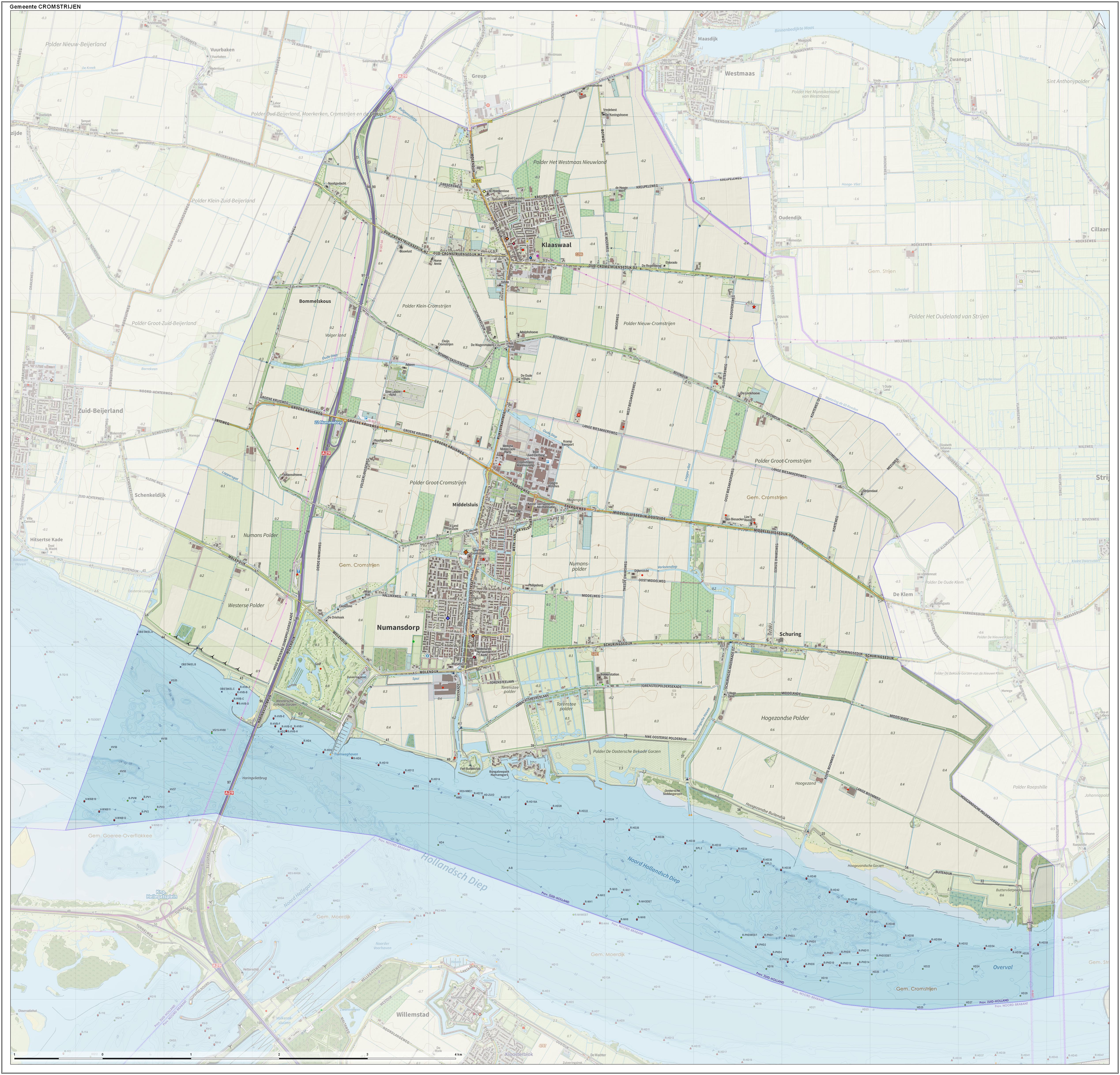
Cromstrijen (; ''Cromstrien'' in local dialect) was a municipality on the Hoeksche Waard Island in the western Netherlands, in the province of South Holland. The municipality covers an area of of which is water. It was formed on 1 January 1984, when the municipalities on the Hoeksche Waard were merged into larger municipalities. On 1 January 2019 it was merged with the municipalities of Binnenmaas, Korendijk, Oud-Beijerland, and Strijen to form the municipality of Hoeksche Waard The Hoekse Waard (; pre-1947 spelling: Hoeksche Waard) is an island between the Oude Maas, Dordtsche Kil, Hollands Diep, Haringvliet and Spui rivers in the province of South Holland in the Netherlands. The island, part of the namesake munic .... The municipality of Cromstrijen consists of the communities Klaaswaal and Numansdorp (townhall). Its population was in . Topography ''Dutch topographic map of the municipality of Cromstrijen, June 2015'' See also References External linksO ... [...More Info...] [...Related Items...] OR: [Wikipedia] [Google] [Baidu] |
Cillaarshoek
Cillaarshoek is a hamlet in the western Netherlands. It is located in the municipality of Hoeksche Waard, South Holland, about 15 km south of Rotterdam Rotterdam ( , , , lit. ''The Dam on the River Rotte'') is the second largest city and municipality in the Netherlands. It is in the province of South Holland, part of the North Sea mouth of the Rhine–Meuse–Scheldt delta, via the ''"Ne .... Cillaarshoek was a separate municipality between 1817 and 1832, when it became part of the municipality of Maasdam. In 1984, it became a part of the existing municipality of Strijen while the rest of the municipality of Maasdam was merged into the new municipality of BinnenmaasAd van der Meer and Onno Boonstra, "Repertorium van Nederlandse gemeenten", KNAW, 2006. The Dutch Reformed church is an aisleless with a little wooden tower which was built shortly after its predecessor was demolished in 1838. Cillaarshoek is not a statistical entity, and considered part of Klaas ... [...More Info...] [...Related Items...] OR: [Wikipedia] [Google] [Baidu] |
List Of Sovereign States
The following is a list providing an overview of sovereign states around the world with information on their status and recognition of their sovereignty. The 206 listed states can be divided into three categories based on membership within the United Nations System: 193 UN member states, 2 UN General Assembly non-member observer states, and 11 other states. The ''sovereignty dispute'' column indicates states having undisputed sovereignty (188 states, of which there are 187 UN member states and 1 UN General Assembly non-member observer state), states having disputed sovereignty (16 states, of which there are 6 UN member states, 1 UN General Assembly non-member observer state, and 9 de facto states), and states having a special political status (2 states, both in free association with New Zealand). Compiling a list such as this can be a complicated and controversial process, as there is no definition that is binding on all the members of the community of nations concerni ... [...More Info...] [...Related Items...] OR: [Wikipedia] [Google] [Baidu] |


