|
South Ronaldsay
South Ronaldsay (, also , sco, Sooth Ronalshee) is one of the Orkney Islands off the north coast of Scotland. It is linked to the Orkney Mainland by the Churchill Barriers, running via Burray, Glimps Holm and Lamb Holm. Name Along with North Ronaldsay, the island is named after St Ronald. The original name from which the English name derives, ''Rǫgnvaldsey'', comes from Old Norse; ''Rǫgnvalds'' ("Ronald's") + ''ey'' ("island"). Geography and geology With an area of , it is the fourth largest of the Orkney islands after The Mainland, Hoy and Sanday. Ferries sail from Burwick on the island to John o' Groats on the Scottish mainland and from St Margaret's Hope to Gills Bay.Wenham, Sheena "The South Isles" in Omand (2003) p. 212. South Ronaldsay's main village is St Margaret's Hope, Orkney's third largest settlement. It is named either after Margaret, Maid of Norway, the heir to the Scottish throne who died in Orkney age sevenWenham, Sheena "The South Isles" in Omand (200 ... [...More Info...] [...Related Items...] OR: [Wikipedia] [Google] [Baidu] |
St Margaret's Hope
St Margaret's Hope is a village in the Orkney Islands, off the north coast of Scotland. It is known locally as "The Hope" or "The Hup". With a population of about 550, it is Orkney's third largest settlement after Kirkwall and Stromness. St Margaret's Hope is the main settlement of the island of South Ronaldsay. Situated off Water Sound at the head of a calm bay on the island's northern coast, it is connected to the Orkney Mainland by the A961 road running across the Churchill Barriers. St Margaret's Hope is believed to have been named after either Saint Margaret of Scotland (c.1045-1093), the wife of Malcolm III, or Margaret, Maid of Norway, who died in Orkney and possibly in this location in 1290. The village has a primary school, a small blacksmith's museum, a few shops and a cafe, a pub and a wine bar. Pentland Ferries run a reliable service from the pier in the bay to Gills Bay on the Scottish mainland. It is also known for its annual Boys' Ploughing Match A pl ... [...More Info...] [...Related Items...] OR: [Wikipedia] [Google] [Baidu] |
Gills Bay
Gills Bay, which is situated about west of John o' Groats with the community of Gills close by, has one of the longest stretches of low-lying rock coast on the northern shores of Caithness. Its main features are a small harbour and the pier used as the mainland terminal for Pentland Ferries. The harbour shelters some small local boats together with those used for working the sheep on the off lying island of Stroma. In the right sea conditions the area is sometimes used for surfing. Short sea crossing While Scrabster to Stromness is the longest continuously used ferry route to Orkney, started in 1856, historically the Gills Bay area has been the main setting off point from the mainland to the islands of Stroma and Swona and Orkney itself. This route, known as The Short Sea Crossing, is generally considered to be both the quickest and safest across the waters of the Pentland Firth. At present Pentland Ferries operate a year-round service on this route to St Margaret's Hope on S ... [...More Info...] [...Related Items...] OR: [Wikipedia] [Google] [Baidu] |
Liddle Burnt Mound
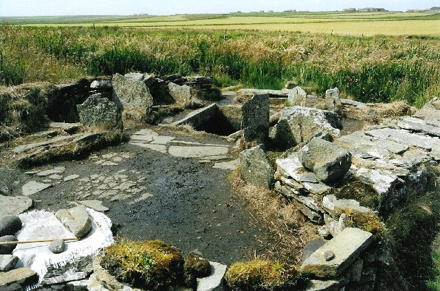
Liddle Burnt Mound is a Bronze Age site on the island of South Ronaldsay, Orkney. The site consists of the remains of a building and a mound that surrounds it on three sides.Hedges 1985, p. 17 The purpose of the site is controversial, but most investigators believe burnt mounds hosted a "domestic function", perhaps related to cooking. Description The Liddle Burnt Mound is located on Liddle Farm; the farmer, Ronald Simison, had been using the mound as a quarry for road metal until he came across stone structures in 1972.Ritchie 1995, p. 94 He alerted Colin Renfrew who was excavating at Quanterness. John Hedges, a member of his team, investigated the site and recognized the remains of a stone building at the centre of the mound. The building is oval with thick external walls. From these, interior walls project into the main room creating compartments, one of which houses a hearth. In the centre of the structure is a large recessed, stone tank, lined with flagstones and rendered wa ... [...More Info...] [...Related Items...] OR: [Wikipedia] [Google] [Baidu] |
Haliaeetus Albicilla
The white-tailed eagle (''Haliaeetus albicilla'') is a very large species of sea eagle widely distributed across temperate Eurasia. Like all eagles, it is a member of the family Accipitridae (or accipitrids) which includes other diurnal raptors such as hawks, kites, and harriers. One of up to eleven members in the genus ''Haliaeetus'', which are commonly called sea eagles, it is also referred to as the white-tailed sea-eagle.Helander, B., & Stjernberg, T. (2003). ''Action plan for the conservation of white-tailed sea eagle (''Haliaeetus albicilla'')''. In Convention on the Conservation of European Wildlife and Natural Habitats, Strasbourg, France. Sometimes, it is known as the ern or erne (depending on spelling by sources),Love, J. A. (1983). ''The return of the Sea Eagle''. Cambridge University Press, . gray sea eagle and Eurasian sea eagle. While found across a very wide range, today breeding as far west as Greenland and Iceland across to as far east as Hokkaido, Japan, they a ... [...More Info...] [...Related Items...] OR: [Wikipedia] [Google] [Baidu] |
Neolithic
The Neolithic period, or New Stone Age, is an Old World archaeological period and the final division of the Stone Age. It saw the Neolithic Revolution, a wide-ranging set of developments that appear to have arisen independently in several parts of the world. This "Neolithic package" included the introduction of farming, domestication of animals, and change from a hunter-gatherer lifestyle to one of settlement. It began about 12,000 years ago when farming appeared in the Epipalaeolithic Near East, and later in other parts of the world. The Neolithic lasted in the Near East until the transitional period of the Chalcolithic (Copper Age) from about 6,500 years ago (4500 BC), marked by the development of metallurgy, leading up to the Bronze Age and Iron Age. In other places the Neolithic followed the Mesolithic (Middle Stone Age) and then lasted until later. In Ancient Egypt, the Neolithic lasted until the Protodynastic period, 3150 BC.Karin Sowada and Peter Grave. Egypt in th ... [...More Info...] [...Related Items...] OR: [Wikipedia] [Google] [Baidu] |
Island
An island (or isle) is an isolated piece of habitat that is surrounded by a dramatically different habitat, such as water. Very small islands such as emergent land features on atolls can be called islets, skerries, cays or keys. An island in a river or a lake island may be called an eyot or ait, and a small island off the coast may be called a holm. Sedimentary islands in the Ganges delta are called chars. A grouping of geographically or geologically related islands, such as the Philippines, is referred to as an archipelago. There are two main types of islands in the sea: continental and oceanic. There are also artificial islands, which are man-made. Etymology The word ''island'' derives from Middle English ''iland'', from Old English ''igland'' (from ''ig'' or ''ieg'', similarly meaning 'island' when used independently, and -land carrying its contemporary meaning; cf. Dutch ''eiland'' ("island"), German ''Eiland'' ("small island")). However, the spelling of the word ... [...More Info...] [...Related Items...] OR: [Wikipedia] [Google] [Baidu] |
Tomb Of The Eagles
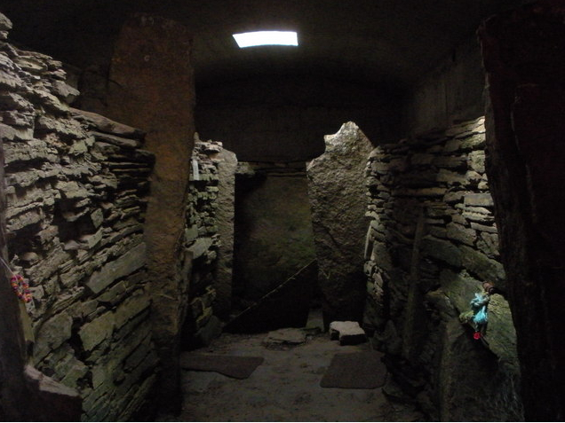
The Tomb of the Eagles, or Isbister Chambered Cairn, is a Neolithic chambered tomb located on a cliff edge at Isbister on South Ronaldsay in Orkney, Scotland. The site was discovered by Ronald Simison, a farmer, when digging flagstones in 1958; he conducted a limited excavation and removed some bones and skulls at that time but filled in the site with dirt. A more extensive excavation was started in 1976, and "an enormous amount of material was removed", according to a report published in 2002. Alerted by Simison, archaeologist John Hedges mounted a full study, prepared a technical report and wrote a popular book that cemented the tomb's name. The Archaeological Journal review of the Hedges book (''Tomb of the eagles a window on Stone Age tribal Britain'') provided a less than stellar rating: "reasonably well done", "but how very much better it might have been". The findings At the site, 16,000 human bones have been found, from at least 324 individuals, but no intact skelet ... [...More Info...] [...Related Items...] OR: [Wikipedia] [Google] [Baidu] |
Beacon
A beacon is an intentionally conspicuous device designed to attract attention to a specific location. A common example is the lighthouse, which draws attention to a fixed point that can be used to navigate around obstacles or into port. More modern examples include a variety of radio beacons that can be read on radio direction finders in all weather, and radar transponders that appear on radar displays. Beacons can also be combined with semaphoric or other indicators to provide important information, such as the status of an airport, by the colour and rotational pattern of its airport beacon, or of pending weather as indicated on a weather beacon mounted at the top of a tall building or similar site. When used in such fashion, beacons can be considered a form of optical telegraphy. For navigation Beacons help guide navigators to their destinations. Types of navigational beacons include radar reflectors, radio beacons, sonic and visual signals. Visual beacons range from sma ... [...More Info...] [...Related Items...] OR: [Wikipedia] [Google] [Baidu] |
Ayre (landform)
An ayre is the name used for shingle beaches found in Orkney, Shetland, the Isle of Man, Lancashire, Cumbria and Northumbria. The word is derived from the Old Norse ''eyrr'', meaning a shingle beach or gravelly place, and may be applied to ordinary beaches, cliff-foot beaches such as the Lang Ayre in Northmavine, Shetland, spits, bars or tombolos, but only if formed of shingle. More than 130 such shingle beaches are named on Ordnance Survey maps of Shetland, but far fewer in Orkney, where most beaches are formed of sand. The word in its Old Norse form is common in Iceland, and it also occurs in a few place names in the north and west of the Scottish mainland which had a strong Norse influence, such as Eriboll ("a homestead on a shingle beach") and in the names of several shingle banks—Salt Ayre, Green Ayre, Stake Ayre, Rabbit Ayre and Whinny Ayre—in the tidal reach of the River Lune at Lancaster. Churchill Barrier number 4 in Orkney used a shingle spit, the Ayre of Cara on ... [...More Info...] [...Related Items...] OR: [Wikipedia] [Google] [Baidu] |
Museum
A museum ( ; plural museums or, rarely, musea) is a building or institution that cares for and displays a collection of artifacts and other objects of artistic, cultural, historical, or scientific importance. Many public museums make these items available for public viewing through exhibits that may be permanent or temporary. The largest museums are located in major cities throughout the world, while thousands of local museums exist in smaller cities, towns, and rural areas. Museums have varying aims, ranging from the conservation and documentation of their collection, serving researchers and specialists, to catering to the general public. The goal of serving researchers is not only scientific, but intended to serve the general public. There are many types of museums, including art museums, natural history museums, science museums, war museums, and children's museums. According to the International Council of Museums (ICOM), there are more than 55,000 museums in 202 countrie ... [...More Info...] [...Related Items...] OR: [Wikipedia] [Google] [Baidu] |


.jpg)


