|
Shropshire, England
Shropshire (; alternatively Salop; abbreviated in print only as Shrops; demonym Salopian ) is a landlocked historic county in the West Midlands region of England. It is bordered by Wales to the west and the English counties of Cheshire to the north, Staffordshire to the east, Worcestershire to the southeast, and Herefordshire to the south. A unitary authority of the same name was created in 2009, taking over from the previous county council and five district councils, now governed by Shropshire Council. The borough of Telford and Wrekin has been a separate unitary authority since 1998, but remains part of the ceremonial county. The county's population and economy is centred on five towns: the county town of Shrewsbury, which is culturally and historically important and close to the centre of the county; Telford, which was founded as a new town in the east which was constructed around a number of older towns, most notably Wellington, Dawley and Madeley, which is today the m ... [...More Info...] [...Related Items...] OR: [Wikipedia] [Google] [Baidu] |
Shrewsbury
Shrewsbury ( , also ) is a market town, civil parish, and the county town of Shropshire, England, on the River Severn, north-west of London; at the 2021 census, it had a population of 76,782. The town's name can be pronounced as either 'Shrowsbury' or 'Shroosbury', the correct pronunciation being a matter of longstanding debate. The town centre has a largely unspoilt medieval street plan and over 660 listed buildings, including several examples of timber framing from the 15th and 16th centuries. Shrewsbury Castle, a red sandstone fortification, and Shrewsbury Abbey, a former Benedictine monastery, were founded in 1074 and 1083 respectively by the Norman Earl of Shrewsbury, Roger de Montgomery. The town is the birthplace of Charles Darwin and is where he spent 27 years of his life. east of the Welsh border, Shrewsbury serves as the commercial centre for Shropshire and mid-Wales, with a retail output of over £299 million per year and light industry and distribution centre ... [...More Info...] [...Related Items...] OR: [Wikipedia] [Google] [Baidu] |
Herefordshire
Herefordshire () is a county in the West Midlands of England, governed by Herefordshire Council. It is bordered by Shropshire to the north, Worcestershire to the east, Gloucestershire to the south-east, and the Welsh counties of Monmouthshire and Powys to the west. Hereford, the county town of Herefordshire has a population of approximately 61,000, making it the largest settlement in the county. The next biggest town is Leominster and then Ross-on-Wye. The county is situated in the historic Welsh Marches, Herefordshire is one of the most rural and sparsely populated counties in England, with a population density of 82/km2 (212/sq mi), and a 2021 population of 187,100 – the fourth-smallest of any ceremonial county in England. The land use is mostly agricultural and the county is well known for its fruit and cider production, and for the Hereford cattle breed. Constitution From 1974 to 1998, Herefordshire was part of the former non-metropolitan county of Hereford and Wor ... [...More Info...] [...Related Items...] OR: [Wikipedia] [Google] [Baidu] |
Market Town
A market town is a settlement most common in Europe that obtained by custom or royal charter, in the Middle Ages, a market right, which allowed it to host a regular market; this distinguished it from a village or city. In Britain, small rural towns with a hinterland of villages are still commonly called market towns, as sometimes reflected in their names (e.g. Downham Market, Market Rasen, or Market Drayton). Modern markets are often in special halls, but this is a recent development, and the rise of permanent retail establishments has reduced the need for periodic markets. Historically the markets were open-air, held in what is usually called (regardless of its actual shape) the market square (or "Market Place" etc), and centred on a market cross ( mercat cross in Scotland). They were and are typically open one or two days a week. History The primary purpose of a market town is the provision of goods and services to the surrounding locality. Although market towns were kno ... [...More Info...] [...Related Items...] OR: [Wikipedia] [Google] [Baidu] |
:Category:Market Towns In Shropshire
Market towns in Shropshire, England. Shropshire Shropshire (; alternatively Salop; abbreviated in print only as Shrops; demonym Salopian ) is a landlocked historic county in the West Midlands region of England. It is bordered by Wales to the west and the English counties of Cheshire to th ... Economy of Shropshire ... [...More Info...] [...Related Items...] OR: [Wikipedia] [Google] [Baidu] |
Ludlow
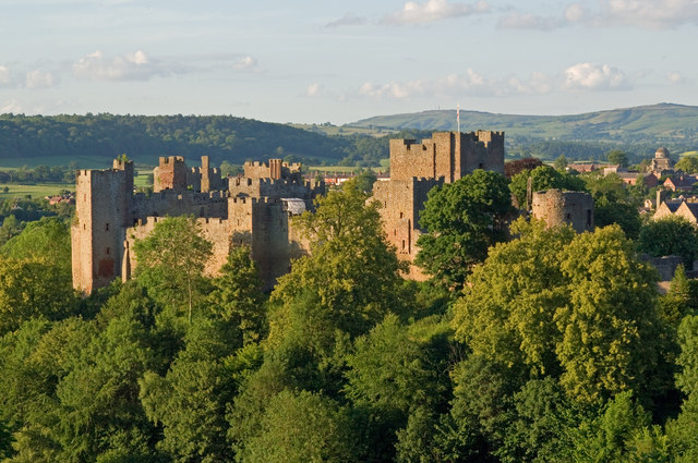
Ludlow () is a market town in Shropshire, England. The town is significant in the history of the Welsh Marches and in relation to Wales. It is located south of Shrewsbury and north of Hereford, on the A49 road which bypasses the town. The town is near the confluence of the rivers Corve and Teme. The oldest part is the medieval walled town, founded in the late 11th century after the Norman conquest of England. It is centred on a small hill which lies on the eastern bank of a bend of the River Teme. Situated on this hill are Ludlow Castle and the parish church, St Laurence's, the largest in the county. From there the streets slope downward to the rivers Corve and Teme, to the north and south respectively. The town is in a sheltered spot beneath Mortimer Forest and the Clee Hills, which are clearly visible from the town. Ludlow has nearly 500 listed buildings, including examples of medieval and Tudor-style half-timbered buildings. The town was described by Sir John Betjeman ... [...More Info...] [...Related Items...] OR: [Wikipedia] [Google] [Baidu] |
Bridgnorth
Bridgnorth is a town in Shropshire, England. The River Severn splits it into High Town and Low Town, the upper town on the right bank and the lower on the left bank of the River Severn. The population at the 2011 Census was 12,079. History Bridgnorth is named after a bridge over the River Severn, which was built further north than an earlier bridge at Quatford. The earliest historical reference to the town is in 895, when it is recorded that the Danes created a camp at ''Cwatbridge''; subsequently in 912, Æthelfleda constructed a mound on the west bank of the River Severn, or possibly on the site of Bridgnorth Castle, as part of an offensive against the Danes. Earliest names for Bridgnorth include Brigge, Brug and Bruges, all referring to its position on the Severn. After the Norman conquest, William I granted the manor of Bridgnorth to Roger de Montgomerie. The town itself was not created until 1101, when Robert of Bellême, 3rd Earl of Shrewsbury, the son of Roger de M ... [...More Info...] [...Related Items...] OR: [Wikipedia] [Google] [Baidu] |
Oswestry
Oswestry ( ; ) is a market town, civil parish and historic railway town in Shropshire, England, close to the Welsh border. It is at the junction of the A5, A483 and A495 roads. The town was the administrative headquarters of the Borough of Oswestry until that was abolished in 2009. Oswestry is the third-largest town in Shropshire, following Telford and Shrewsbury. At the 2011 Census, the population was 17,105. The town is five miles (8 km) from the Welsh border and has a mixed English and Welsh heritage. Oswestry is the largest settlement within the Oswestry Uplands, a designated natural area and national character area. Toponym The name ''Oswestry'' is first attested in 1191, as ''Oswaldestroe''. This Middle English name transparently derives from the Old English personal name Ōswald and the word ''trēow'' ('tree'). Thus the name seems once to have meant 'tree of a man called Ōswald'.A. D. Mills, ''A Dictionary of English Place Names'' (Oxford: Oxford Universit ... [...More Info...] [...Related Items...] OR: [Wikipedia] [Google] [Baidu] |
Madeley, Shropshire
Madeley is a constituent town and civil parish in Telford and Wrekin in Shropshire, England. The parish had a population of 17,935 at the 2001 census. Madeley is recorded in the Domesday Book, having been founded before the 8th century. Historically, Madeley's industrial activity has largely been in mining, and later, manufacturing, which is still a large employer in the town, along with service industries. Parts of the parish fall within the UNESCO World Heritage Site of Ironbridge Gorge, the site of The Iron Bridge, and a key area in the development of Industry. History The settlement of Madeley is recorded as far back as the Domesday Book. The town was founded prior to the 8th century, and subsequently became a market town in the 13th century. Sigward, a local ruler in the time of King Æthelbald of Mercia, is said to have held 3 hides of land at Madeley. Between 727 and 736 he sold his holdings to Mildburh, daughter of Merewalh, sub-king of the Magonsæte. She was the ... [...More Info...] [...Related Items...] OR: [Wikipedia] [Google] [Baidu] |
Dawley
Dawley ( ) is a constituent town and civil parish in Telford and Wrekin in Shropshire, England. It was originally, in 1963, going to be the main centre of the 'Dawley New Town' plan before it was decided in 1968 to name the new town as 'Telford', after the engineer and road-builder Thomas Telford. Dawley now forms part of Telford which is north of the town itself. Dawley is one of the older settlements in Shropshire, being mentioned in the Domesday Book (1086). It is divided into ''Dawley Magna'' ("Great Dawley") and Little Dawley (also shown as ''Dawley Parva'' ("Little Dawley") on older maps). Etymology The name Dawley comes from Old English meaning ''woodland clearing associated with a man called Dealla''. Local government The town's main civil parish is officially called Great Dawley – its parish council is officially Great Dawley Town Council. Dawley Hamlets is a separate civil parish, which covers Little Dawley and other neighbouring villages/suburbs. Railways The ne ... [...More Info...] [...Related Items...] OR: [Wikipedia] [Google] [Baidu] |
Wellington, Shropshire
Wellington is a market town in Telford and Wrekin, Shropshire, England. It is situated 4 miles (6 km) northwest of central Telford and 12 miles (19 km) east of Shrewsbury. The summit of The Wrekin lies 3 miles southwest of the town. The total town population of Wellington was 25,554 in 2011, making it by far the largest of the borough towns and the third largest town in Shropshire if counting it as its own town separate from Telford itself. History A church has stood for almost 1,000 years and a priest is mentioned in the Domesday Book. The original churchyard still remains. A new church, designed by George Steuart, was built in 1789. Wellington's first market charter was granted to Giles of Erdington, lord of the manor, in 1244 and a market still exists today. The market had an open-sided market hall by 1680, and possibly much earlier, but it was dismantled in about 1805. In 1841 a market company was formed to purchase the market rights from Lord Forester in 1856. In ... [...More Info...] [...Related Items...] OR: [Wikipedia] [Google] [Baidu] |
New Town
New is an adjective referring to something recently made, discovered, or created. New or NEW may refer to: Music * New, singer of K-pop group The Boyz Albums and EPs * ''New'' (album), by Paul McCartney, 2013 * ''New'' (EP), by Regurgitator, 1995 Songs * "New" (Daya song), 2017 * "New" (Paul McCartney song), 2013 * "New" (No Doubt song), 1999 *"new", by Loona from '' Yves'', 2017 *"The New", by Interpol from ''Turn On the Bright Lights'', 2002 Acronyms * Net economic welfare, a proposed macroeconomic indicator * Net explosive weight, also known as net explosive quantity * Network of enlightened Women, a conservative university women's organization * Next Entertainment World, a South Korean film distribution company Identification codes * Nepal Bhasa language ISO 639 language code * New Century Financial Corporation (NYSE stock abbreviation) * Northeast Wrestling, a professional wrestling promotion in the northeastern United States Transport * New Orleans Lakefront Ai ... [...More Info...] [...Related Items...] OR: [Wikipedia] [Google] [Baidu] |
Telford
Telford () is a town in the borough of Telford and Wrekin and ceremonial county of Shropshire, England, about east of Shrewsbury, south west of Stafford, north west of Wolverhampton and from Birmingham in the same direction. With an estimated population (for the borough) of 175,271 in 2017 and 142,723 in Telford itself, Telford is the largest town in Shropshire and one of the fastest-growing towns in the United Kingdom. It is named after the civil engineer Thomas Telford, who engineered many road, canal and rail projects in Shropshire. The town was put together in the 1960s and 1970s as a new town on previously industrial and agricultural land and towns. Like other planned towns of the era, Telford was created from the merger of other settlements and towns, most notably the towns of Wellington, Oakengates, Madeley and Dawley. Telford Shopping Centre, a modern shopping mall, was constructed at the new town's geographical centre, along with an extensive Town Park. Th ... [...More Info...] [...Related Items...] OR: [Wikipedia] [Google] [Baidu] |


