|
Seymour-FM
Seymour FM is a regional community radio station for the Northern Mitchell and Southern Strathbogie Shires, operating from Seymour, Victoria, Seymour township in North Central Victoria, part of the state of Victoria (Australia), Victoria, Australia. The radio station operates on a Long Term Community Broadcasting Licence, transmitting from studios at the Kings Park complex in Seymour. History Seymour FM was established in 2001, under the identity SPI FM. The station was originally intended as a local service for Seymour, Victoria, Seymour and nearby Puckapunyal. This service was lacking in key skill areas, and failed to attract the interest of listeners or sponsors, and faltered in 2004. In 2005, a new committee was established to restore a local Seymour based radio service. The new identity of "Seymour FM" was established, and a series of new presenters commenced programs, along with promotions activity with the revised name and image. Early in 2009, the radio station manag ... [...More Info...] [...Related Items...] OR: [Wikipedia] [Google] [Baidu] |
Nagambie
Nagambie is a town in the Goulburn Valley region of Victoria, Australia, Victoria, Australia. The city is on the Goulburn Valley Freeway north of Seymour, Victoria, Seymour and in the Shire of Strathbogie. As of , Nagambie had a population of 2,254. History The Nagambie Region is within the traditional lands of the Taungurung people, who are the first people of the rivers, valleys and mountains in this region. The Taungurung people lived according to the natural cycles and rhythms of the land moving through their country seasonally, occupying the more cooler mountain areas in summer and autumn and the tributaries of the Goulburn River in winter and spring. The Goulburn River at Nagambie, prior to the formation of the lakes through the creation of the Goulburn Weir, was the site of several lagoons, which along with nearby Reedy lake provided an ideal camping place for the Taungurung people. The river and the associated tributaries and wetlands provided an abundance of food ... [...More Info...] [...Related Items...] OR: [Wikipedia] [Google] [Baidu] |
Seymour, Victoria
Seymour () is a historic railway township located in the Southern end of the Goulburn Valley in the Shire of Mitchell, Victoria, Australia and is located north of Melbourne. At the , Seymour had a population of 6,569. The township services the surrounding agricultural industries (primarily equine, cattle, sheep and wine) as well as the nearby military base of Puckapunyal (population 1,176), which is an important training centre for the Australian Army. Other important sectors of employment in Seymour include retail, light engineering, agricultural services support, medical services, and education. History The Taungurung people are the traditional owners and inhabitants of the area Seymour now occupies. Specifically, it is the land of the Buthera Balug clan who occupied the area when Europeans first settled the region in the early 1800s. In 1824, Hume and Hovell on their return from Port Phillip, camped by the Goulburn River not far upstream of Seymour. In 1836 Major Thomas Mi ... [...More Info...] [...Related Items...] OR: [Wikipedia] [Google] [Baidu] |
FM Radio
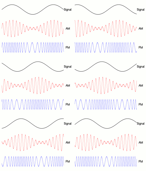
FM broadcasting is a method of radio broadcasting using frequency modulation (FM). Invented in 1933 by American engineer Edwin Armstrong, wide-band FM is used worldwide to provide high fidelity sound over broadcast radio. FM broadcasting is capable of higher fidelity—that is, more accurate reproduction of the original program sound—than other broadcasting technologies, such as AM broadcasting. It is also less susceptible to common forms of interference, reducing static and popping sounds often heard on AM. Therefore, FM is used for most broadcasts of music or general audio (in the audio spectrum). FM radio stations use the very high frequency range of radio frequencies. Broadcast bands Throughout the world, the FM broadcast band falls within the VHF part of the radio spectrum. Usually 87.5 to 108.0 MHz is used, or some portion thereof, with few exceptions: * In the former Soviet republics, and some former Eastern Bloc countries, the older 65.8–74 MHz band ... [...More Info...] [...Related Items...] OR: [Wikipedia] [Google] [Baidu] |
Community Radio
Community radio is a radio service offering a third model of radio broadcasting in addition to commercial and public broadcasting. Community stations serve geographic communities and communities of interest. They broadcast content that is popular and relevant to a local, specific audience but is often overlooked by commercial (or) mass-media broadcasters. Community radio stations are operated, owned, and influenced by the communities they serve. They are generally nonprofit and provide a mechanism for enabling individuals, groups, and communities to tell their own stories, to share experiences and, in a media-rich world, to become creators and contributors of media. In many parts of the world, community radio acts as a vehicle for the community and voluntary sector, civil society, agencies, NGOs and citizens to work in partnership to further community development aims, in addition to broadcasting. There is legally defined community radio (as a distinct broadcasting sector) in many ... [...More Info...] [...Related Items...] OR: [Wikipedia] [Google] [Baidu] |
Victoria (Australia)
Victoria is a state in southeastern Australia. It is the second-smallest state with a land area of , the second most populated state (after New South Wales) with a population of over 6.5 million, and the most densely populated state in Australia (28 per km2). Victoria is bordered by New South Wales to the north and South Australia to the west, and is bounded by the Bass Strait to the south (with the exception of a small land border with Tasmania located along Boundary Islet), the Great Australian Bight portion of the Southern Ocean to the southwest, and the Tasman Sea (a marginal sea of the South Pacific Ocean) to the southeast. The state encompasses a range of climates and geographical features from its temperate coastal and central regions to the Victorian Alps in the northeast and the semi-arid north-west. The majority of the Victorian population is concentrated in the central-south area surrounding Port Phillip Bay, and in particular within the metropolit ... [...More Info...] [...Related Items...] OR: [Wikipedia] [Google] [Baidu] |
Puckapunyal
Puckapunyal (more formally the Puckapunyal Military Area, but also known as the Puckapunyal Camp or Puckapunyal Army Base, and colloquially as "Pucka") is an Australian Army training facility and base 10 km west of Seymour, in central Victoria, south-eastern Australia.Dennis et al. (eds.), ''The Oxford Companion to Australian Military History'', p. 435 Description Puckapunyal is a small restricted-access town inhabited mainly by about 280 families of the Australian Defence Force community, with an associated area of about 400 km2 of bushland and former pasture used for field training exercises. It is home to the Australian Army's School of Armour, the School of Artillery and the School of Transport, along with the Combined Arms Training Centre, the Joint Logistics Unit, and two transport squadrons. The Royal Australian Armoured Corps Memorial and Army Tank Museum is on the base's grounds, and the facilities are used by the Victorian Australian Army Cadets Brigade. ... [...More Info...] [...Related Items...] OR: [Wikipedia] [Google] [Baidu] |
Shire Of Mitchell
The Shire of Mitchell is a local government area in the Hume region of Victoria, Australia, located North of Melbourne. It covers an area of and, in June 2018, had a population of 44,299. It includes the towns of Broadford, Kilmore, Seymour, Tallarook, Pyalong and Wallan. It was formed in 1994 from the amalgamation of the Shire of Pyalong, the Shire of Kilmore, most of the Shire of Broadford, and parts of the Shire of McIvor and Rural City of Seymour. The Shire is governed and administered by the Mitchell Shire Council; its seat of local government and administrative centre is located at the council headquarters in Broadford, it also has service centres located in Kilmore, Seymour and Wallan. The Shire is named after an early British surveyor and explorer, Major Thomas Mitchell, who explored the south-eastern part of Australia, and whose return route for his third expedition passed through the present-day LGA. It is one of the fastest growing regional municipalities in Vic ... [...More Info...] [...Related Items...] OR: [Wikipedia] [Google] [Baidu] |
Melbourne
Melbourne ( ; Boonwurrung/Woiwurrung: ''Narrm'' or ''Naarm'') is the capital and most populous city of the Australian state of Victoria, and the second-most populous city in both Australia and Oceania. Its name generally refers to a metropolitan area known as Greater Melbourne, comprising an urban agglomeration of 31 local municipalities, although the name is also used specifically for the local municipality of City of Melbourne based around its central business area. The metropolis occupies much of the northern and eastern coastlines of Port Phillip Bay and spreads into the Mornington Peninsula, part of West Gippsland, as well as the hinterlands towards the Yarra Valley, the Dandenong and Macedon Ranges. It has a population over 5 million (19% of the population of Australia, as per 2021 census), mostly residing to the east side of the city centre, and its inhabitants are commonly referred to as "Melburnians". The area of Melbourne has been home to Aboriginal ... [...More Info...] [...Related Items...] OR: [Wikipedia] [Google] [Baidu] |
Shepparton
Shepparton () ( Yortayorta: ''Kanny-goopna'') is a city located on the floodplain of the Goulburn River in northern Victoria, Australia, approximately north-northeast of Melbourne. As of the 2021 census, the estimated population of Shepparton, including the adjacent town of Mooroopna, was 68,409. It began as a sheep station and river crossing in the mid-19th century, before undergoing a major transformation as a railway town. Today it is an agricultural and manufacturing centre, and the centre of the Goulburn Valley irrigation system, one of the largest centres of irrigation in Australia. It is also a major regional service city and the seat of local government and civic administration for the City of Greater Shepparton, which includes the surrounding towns of Tatura, Merrigum, Mooroopna, Murchison, Dookie, Toolamba and Grahamvale. Toponymy The name of Shepparton is derived from the surname of one of the area's first European settlers, Sherbourne Sheppard, and not, as is s ... [...More Info...] [...Related Items...] OR: [Wikipedia] [Google] [Baidu] |
Alexandra, Victoria
Alexandra is a town in north-east Victoria, Australia, 130 kilometres north-east of the State Capital, Melbourne. It is located at the junction of the Goulburn Valley Highway (B340) and Maroondah Highway (B360), in the Shire of Murrindindi local government area. At the , the town had a population of 2,695 and the broader area (Alexandra District) a population of 6420. Gold mining was the catalyst for the development of the town with many mines around Alexandra and particularly along Ultima Thule Creek, known locally as UT Creek, which runs through the town. The town's post office was opened in 1867. The town has a number of parks. Rotary Park is adjacent to UT Creek and the town's main street and includes toilets, barbecues and the Visitor Information Centre. Leckie Park is a larger, picturesque park of over 11 hectares, also along UT Creek. It includes the Alexandra Bowling Club, a playground and the town's cenotaph. Lake Eildon, a major water storage, is 12 kilometres eas ... [...More Info...] [...Related Items...] OR: [Wikipedia] [Google] [Baidu] |
Australian Communications And Media Authority
The Australian Communications and Media Authority (ACMA) is an Australian government statutory authority within the Communications portfolio. ACMA was formed on 1 July 2005 with the merger of the Australian Broadcasting Authority and the Australian Communications Authority. ACMA is responsible for collecting broadcasting, radiocommunication and telecommunication taxes and regulating Australian media. It does this through various legislation, regulations, standards and codes of practice. ACMA is a converged regulator, created to oversee the convergence of telecommunications, broadcasting, radio communications and the internet. Organization ACMA is an independent government agency managed by an executive team comprising the Chair (who is also the Agency Head), Deputy Chair (who is also the chief executive officer). ACMA collects revenue on behalf of the Australian Government through broadcasting, radiocommunications and telecommunications taxes, charges and license fees. It also ... [...More Info...] [...Related Items...] OR: [Wikipedia] [Google] [Baidu] |


