|
Saltoro Ridge
The Saltoro Mountains are a subrange of the Karakoram Range. They are located in the southeast Karakoram on the southwest side of the Siachen Glacier, one of the two longest glaciers outside the polar regions. The name given to this range is shared with the Saltoro Valley which is located to the west of this range, downslope on the Pakistan side of the Saltoro Range which generally follows the Actual Ground Position Line. Saltoro Kangri peak, Saltoro River, and Saltoro Valley are features on this range. The Actual Ground Position Line (AGPL) between Indian and Pakistan held area runs through this range, where the high peaks and passes of the Siachen area are held by Pakistan,the peaks and valleys to the west after successfully taking back control from India in 1999 Kargil war. The Saltoro Mountains are ''Lesser Karakorams'' on the southwestern side of the large Karakoram-glaciers (Siachen, Baltoro, Biafo and Hispar Glacier from east to west) while the main ridge of the Karakora ... [...More Info...] [...Related Items...] OR: [Wikipedia] [Google] [Baidu] |
Actual Ground Position Line
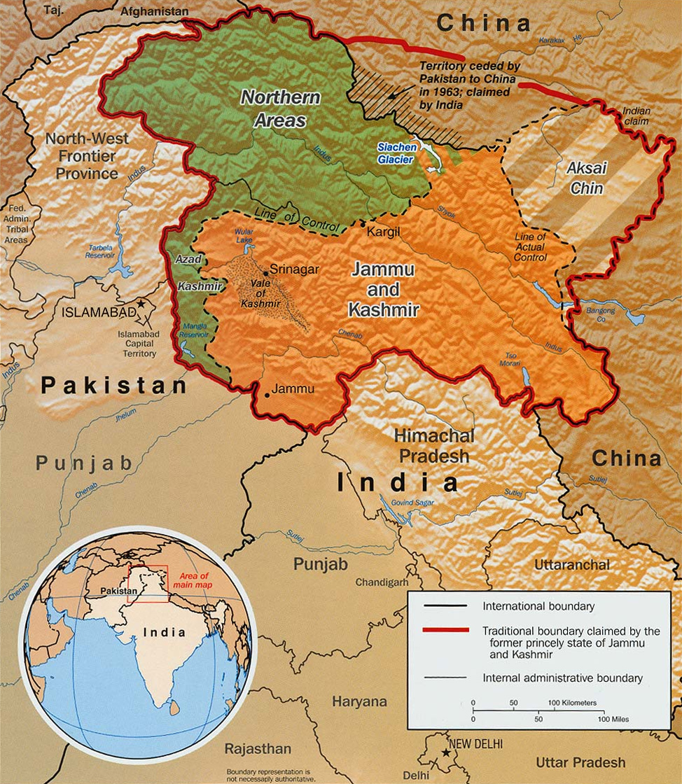
The Actual Ground Position Line (AGPL) divides current positions of Indian and Pakistani military posts and troops across the entire long front line in the disputed region of Siachen Glacier. AGPL generally runs along the Saltoro Mountains range, beginning from the northernmost point of the (LOC) at Point NJ 9842 and ending in the north on the Indira Ridge at the India-China-Pakistan LAC tripoint near Sia Kangri about northwest of Indira Col West, with peaks in excess of and temperatures ranging to around . India gained control of of disputed territory in 1984 because of its military operations in Siachen. A cease-fire was announced in 2003. India has at least 108 forward military outposts and artillery observation posts in this area where temperature goes down to during winters with icy 300 km/h () blizzards. Bana Top () is the highest post and requires an trek that takes up to 20 days for troops to reach. Pahalwan Post (), and Indira Col (), are other high posts. Ind ... [...More Info...] [...Related Items...] OR: [Wikipedia] [Google] [Baidu] |
Shyok River
The Shyok River is a tributary of the Indus River that flows through northern Ladakh and enters Gilgit–Baltistan, spanning some . The Shyok River originates at the Rimo Glacier, one of the tongues of Siachen Glacier. Its alignment is very unusual, originating from the Rimo glacier, it flows in a southeasterly direction and, joining the Pangong range, it takes a northwestern turn, flowing parallel to its previous path. Shyok Valley widens at the confluence with the Nubra River but suddenly turns into a narrow gorge near Yagulung (), continuing through Bogdang, Turtuk and Tyakshi before crossing into Baltistan. The valley again widens near its Saltoro River junction at Ghursay. The river joins the Indus at Keris, east of the town of Skardu. The Nubra River, originating from the Siachen glacier, also behaves like the Shyok. Before Diskit, the southeasterly flowing river Nubra takes a northwest turn on meeting the river Shyok. The similarity in the courses of these two importan ... [...More Info...] [...Related Items...] OR: [Wikipedia] [Google] [Baidu] |
Kashmir Conflict
The Kashmir conflict is a territorial conflict over the Kashmir region, primarily between India and Pakistan, with China playing a third-party role. The conflict started after the partition of India in 1947 as both India and Pakistan claimed the entirety of the former princely state of Jammu and Kashmir. It is a dispute over the region that escalated into three wars between India and Pakistan and several other armed skirmishes. India controls approximately 55% of the land area of the region that includes Jammu, the Kashmir Valley, most of Ladakh, the Siachen Glacier, and 70% of its population; Pakistan controls approximately 30% of the land area that includes Azad Kashmir and Gilgit-Baltistan; and China controls the remaining 15% of the land area that includes the Aksai Chin region, the mostly uninhabited Trans-Karakoram Tract, and part of the Demchok sector. After the partition of India and a rebellion in the western districts of the state, Pakistani tribal militias i ... [...More Info...] [...Related Items...] OR: [Wikipedia] [Google] [Baidu] |
Line Of Control
The Line of Control (LoC) is a military control line between the Indian and Pakistanicontrolled parts of the former princely state of Jammu and Kashmir—a line which does not constitute a legally recognized international boundary, but serves as the de facto border. It was established as part of the Simla Agreement at the end of the Indo-Pakistani War of 1971. Both nations agreed to rename the ceasefire line as the "Line of Control" and pledged to respect it without prejudice to their respective positions. Apart from minor details, the line is roughly the same as the original 1949 cease-fire line. The part of the former princely state under Indian control is divided into the union territories of Jammu and Kashmir and Ladakh. The Pakistani-controlled section is divided into Azad Kashmir and Gilgit–Baltistan. The northernmost point of the Line of Control is known as NJ9842, beyond which lies the Siachen Glacier, which became a bone of contention in 1984. To the south of the ... [...More Info...] [...Related Items...] OR: [Wikipedia] [Google] [Baidu] |
Jammu
Jammu is the winter capital of the Indian union territory of Jammu and Kashmir (union territory), Jammu and Kashmir. It is the headquarters and the largest city in Jammu district of the union territory. Lying on the banks of the river Tawi River, Tawi, the city of Jammu, with an area of , is surrounded by the Himalayas in the north and the Indo-Gangetic Plain, northern-plains in the south. Jammu is the second most populous city of the union territory. Three battles have been fought in the city: first by the founder Raja Mal Dev against Timur in Battle of Jammu (1399), second by Sardar Bhag Singh against Mughal army in Battle of Jammu (1712) and the third by Mian Dido & Maharaja Gulab Singh against Ranjit Singh's army in Battle of Jammu (1808). Known as the ''City of Temples'' for its ancient temples and Hindu shrines, Jammu is the most visited place in the union territory. Jammu city shares its borders with the neighbouring Samba district. Etymology According to local tradit ... [...More Info...] [...Related Items...] OR: [Wikipedia] [Google] [Baidu] |
Dhalan
Dhalan is a village located on a river bank in Jammu district of Jammu and Kashmir union territory of India. Dhalan is located on the India-Pakistan LoC, which begins just north of Dahlan. The important geostrategic Chicken's Neck military sector of Pakistan lies southeast of Dhalan. Dhalan is 36 km from nearest railway station at Akhnoor on the Jammu–Poonch line and 68 km from the nearest airport Jammu Airport. Etymology Dhalan means the slope. History On 30 September 2018, A Pakistani civilian helicopter carrying Pakistani politician Farooq Haider Khan intruded in the Indian airspace in the Gulpur-Dhalan sector, which retracted to Pakistani airspace after warning shots were fired by the Indian forces."Reason Why Pakistani Chopper Was Not Shot-Dow ... [...More Info...] [...Related Items...] OR: [Wikipedia] [Google] [Baidu] |
India–Pakistan Border
The Indo–Pak border or India-Pakistan border is the international boundary that separates India and Pakistan. At its northern end is the Line of Control, which separates Indian-administered Kashmir from Pakistani-administered Kashmir; and at its southern end is Sir Creek, a tidal estuary in the Rann of Kutch between the Indian state of Gujarat and the Pakistani province of Sindh. Originally demarcated on the basis of the Radcliffe Line during the Partition of India, partition of British India in 1947, the border traverses a variety of terrain ranging from major urban areas to inhospitable deserts. Since the beginning of the Indo-Pakistani wars and conflicts, India–Pakistan conflict shortly after the two countries' conjoined independence, it has been the site of numerous cross-border military standoffs and full-scale wars. The border's total length is according to figures given by the PBS; it is also ranked as one of the most dangerous international boundaries in the world, ... [...More Info...] [...Related Items...] OR: [Wikipedia] [Google] [Baidu] |
Sir Creek
Sir Creek ( ), originally Ban Ganga, is a 96-km (60-mi) tidal estuary in the uninhabited marshlands of the Indus River Delta on the border between India and Pakistan. The creek flows into the Arabian Sea and separates Gujarat state in India from Sindh province in Pakistan. The long-standing India-Pakistan Sir Creek border dispute stems from the demarcation "from the mouth of Sir Creek to the top of Sir Creek, and from the top of Sir Creek eastward to a point on the line designated on the Western Terminus". From this point onward, the boundary is unambiguously fixed as defined by the Tribunal Award of 1968. Etymology Sir Creek was originally known as Ban Ganga. It was renamed Sir Creek after a representative of the British Raj. [...More Info...] [...Related Items...] OR: [Wikipedia] [Google] [Baidu] |
Kashmir Map
Kashmir () is the northernmost geographical region of the Indian subcontinent. Until the mid-19th century, the term "Kashmir" denoted only the Kashmir Valley between the Great Himalayas and the Pir Panjal Range. Today, the term encompasses a larger area that includes the Indian-administered territories of Jammu and Kashmir and Ladakh, the Pakistani-administered territories of Azad Kashmir and Gilgit-Baltistan, and the Chinese-administered territories of Aksai Chin and the Trans-Karakoram Tract. Quote: "Kashmir, region of the northwestern Indian subcontinent. It is bounded by the Uygur Autonomous Region of Xinjiang to the northeast and the Tibet Autonomous Region to the east (both parts of China), by the Indian states of Himachal Pradesh and Punjab to the south, by Pakistan to the west, and by Afghanistan to the northwest. The northern and western portions are administered by Pakistan and comprise three areas: Azad Kashmir, Gilgit, and Baltistan, ... The southern and so ... [...More Info...] [...Related Items...] OR: [Wikipedia] [Google] [Baidu] |
Mount Kailash
Mount Kailash (also Kailasa; ''Kangrinboqê'' or ''Gang Rinpoche''; Standard Tibetan, Tibetan: གངས་རིན་པོ་ཆེ; ; sa, कैलास, ), is a mountain in the Ngari Prefecture, Tibet Autonomous Region of China. It has an altitude of . It lies in the Gangdise Shan, Kailash Range (Gangdisê Mountains) of the Transhimalaya, in the western part of the Tibetan Plateau. Mount Kailash is less than 100 km towards the north from the western trijunction of the borders of China, India, and Nepal. Mount Kailash is located close to Lake Manasarovar and Lake Rakshastal. The sources of four major Asian rivers lie close to this mountain and the two lakes. These rivers are the Indus River, Indus, the Sutlej, the Brahmaputra River, Brahmaputra, and the Karnali River, Karnali (a tributary of the Ganges). Mount Kailash is considered sacred in four religions: Hinduism, Buddhism, Jainism and Bon. Etymology The mountain is known as “'” (; var. ' ) in Sanskrit. The nam ... [...More Info...] [...Related Items...] OR: [Wikipedia] [Google] [Baidu] |
Tibet
Tibet (; ''Böd''; ) is a region in East Asia, covering much of the Tibetan Plateau and spanning about . It is the traditional homeland of the Tibetan people. Also resident on the plateau are some other ethnic groups such as Monpa people, Monpa, Tamang people, Tamang, Qiang people, Qiang, Sherpa people, Sherpa and Lhoba peoples and now also considerable numbers of Han Chinese and Hui people, Hui settlers. Since Annexation of Tibet by the People's Republic of China, 1951, the entire plateau has been under the administration of the People's Republic of China, a major portion in the Tibet Autonomous Region, and other portions in the Qinghai and Sichuan provinces. Tibet is the highest region on Earth, with an average elevation of . Located in the Himalayas, the highest elevation in Tibet is Mount Everest, Earth's highest mountain, rising 8,848.86 m (29,032 ft) above sea level. The Tibetan Empire emerged in the 7th century. At its height in the 9th century, the Tibet ... [...More Info...] [...Related Items...] OR: [Wikipedia] [Google] [Baidu] |


.jpg)

