|
SMS Erzherzog Ferdinand Max
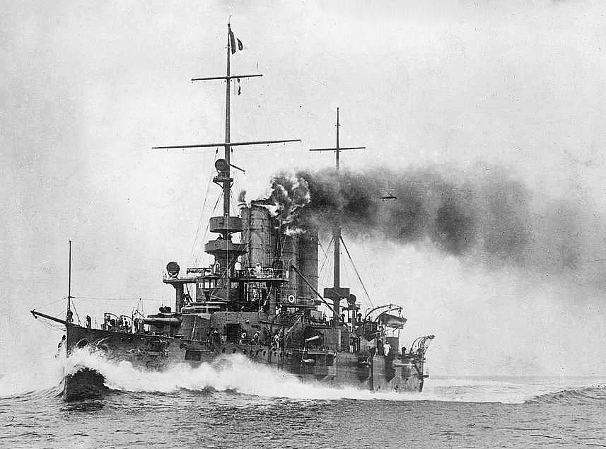
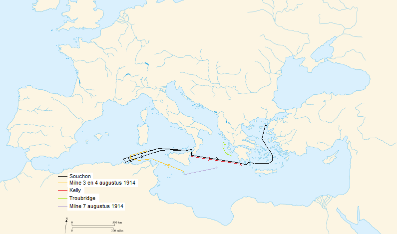
SMS ''Erzherzog Ferdinand Max'' (German: "His Majesty's ship Archduke Ferdinand Max") was a pre-dreadnought battleship built by the Austro-Hungarian Navy in 1902. The second ship of the , she was launched on 21 May 1905. She was assigned to the III Battleship Division. For most of World War I, ''Erzherzog Ferdinand Max'' remained in her home port of Pola, in present-day Croatia, except for four engagements. In 1914, she formed part of the Austro-Hungarian flotilla sent to protect the escape of the German ships SMS ''Goeben'' and SMS ''Breslau'' from the British-held Mediterranean; she advanced as far as Brindisi before being recalled to her home port. Her sole combat engagement occurred in late May 1915, when she participated in the bombardment of the Italian port city of Ancona. She also took part in suppressing a major mutiny among the crew members of several armored cruisers stationed in Cattaro between 1–3 February 1918. She also attempted to break through the Otra ... [...More Info...] [...Related Items...] OR: [Wikipedia] [Google] [Baidu] |
Conning Tower
A conning tower is a raised platform on a ship or submarine, often armored, from which an officer in charge can conn the vessel, controlling movements of the ship by giving orders to those responsible for the ship's engine, rudder, lines, and ground tackle. It is usually located as high on the ship as practical, to give the conning team good visibility of the entirety of the ship, ocean conditions, and other vessels. The naval term "conn" may derive from the Middle English ''conne'' (study, become acquainted with) or French ''conduire'' from Latin ''conducere'' (conduct). Surface ships On surface ships, the conning tower was a feature of all battleships and armored cruisers from about 1860 to the early years of World War II. Located at the front end of the superstructure, the conning tower was a heavily armored cylinder, with tiny slit windows on three sides providing a reasonable field of view. Designed to shield just enough personnel and devices for navigation during battle ... [...More Info...] [...Related Items...] OR: [Wikipedia] [Google] [Baidu] |
Beam (nautical)
The beam of a ship is its width at its widest point. The maximum beam (BMAX) is the distance between planes passing through the outer extremities of the ship, beam of the hull (BH) only includes permanently fixed parts of the hull, and beam at waterline (BWL) is the maximum width where the hull intersects the surface of the water. Generally speaking, the wider the beam of a ship (or boat), the more initial stability it has, at the expense of secondary stability in the event of a capsize, where more energy is required to right the vessel from its inverted position. A ship that heels on her ''beam ends'' has her deck beams nearly vertical. Typical values Typical length-to-beam ratios ( aspect ratios) for small sailboats are from 2:1 (dinghies to trailerable sailboats around ) to 5:1 (racing sailboats over ). Large ships have widely varying beam ratios, some as large as 20:1. Rowing shells designed for flatwater racing may have length to beam ratios as high as 30:1, while a cor ... [...More Info...] [...Related Items...] OR: [Wikipedia] [Google] [Baidu] |
War Prize
A prize of war is a piece of enemy property or land seized by a belligerent party during or after a war or battle, typically at sea. This term was used nearly exclusively in terms of captured ships during the 18th and 19th centuries. Basis in international law Rules defining how prizes were claimed and administered originated before there were organized government navies and were an outgrowth of privateering. Current international treaties provide for the retention of personal property by captured soldiers as well as issues of personal equipment in their possession when captured (including clothing, helmets, rank insignia and medals, and protective equipment such as gas masks), but excluding certain issue items such as weapons, horses, maps, and military documents. Non-personal equipment, vehicles, artillery pieces, ships, stockpiles of food and other material belongs to the capturing state and it may be used without any restriction. Notable prize-takings The 28th Virginia battl ... [...More Info...] [...Related Items...] OR: [Wikipedia] [Google] [Baidu] |
Otranto Barrage
The Otranto Barrage was an Allied naval blockade of the Otranto Straits between Brindisi in Italy and Corfu on the Greek side of the Adriatic Sea in the First World War. The blockade was intended to prevent the Austro-Hungarian Navy from escaping into the Mediterranean and threatening Allied operations there. The blockade was effective in preventing surface ships from escaping the Adriatic, but it had little or no effect on the submarines based at Cattaro. Blockade attempt The Adriatic is wide at the Otranto Straits. The blockade consisted mainly of a fleet of drifters, most of them British, and usually armed with a 6-pounder gun and depth charges.''First World War'' – Willmott, H. P., Dorling Kindersley, 2003, Page 186–187 In 1915 when the blockade was begun, two divisions of 20 would be on patrol at a time, equipped with steel indicator nets intended to trap submarines or at least alert the surface vessels to their presence. A third division would be at Brindisi. The ... [...More Info...] [...Related Items...] OR: [Wikipedia] [Google] [Baidu] |
Cattaro
Kotor (Montenegrin Cyrillic: Котор, ), historically known as Cattaro (from Italian: ), is a coastal town in Montenegro. It is located in a secluded part of the Bay of Kotor. The city has a population of 13,510 and is the administrative center of Kotor Municipality. The old Mediterranean port of Kotor is surrounded by fortifications built during the Venetian period. It is located on the Bay of Kotor (''Boka Kotorska''), one of the most indented parts of the Adriatic Sea. Some have called it the southernmost fjord in Europe, but it is a ria, a submerged river canyon. Together with the nearly overhanging limestone cliffs of Orjen and Lovćen, Kotor and its surrounding area form an impressive landscape. Since the early 2000s Kotor has seen an increase in tourists, many of them coming by cruise ship. Visitors are attracted by the natural environment of the Gulf of Kotor and by the old town of Kotor. Kotor is part of the World Heritage Site dubbed the Natural and Culturo-Hist ... [...More Info...] [...Related Items...] OR: [Wikipedia] [Google] [Baidu] |
Ancona
Ancona (, also , ) is a city and a seaport in the Marche region in central Italy, with a population of around 101,997 . Ancona is the capital of the province of Ancona and of the region. The city is located northeast of Rome, on the Adriatic Sea, between the slopes of the two extremities of the promontory of Monte Conero, Monte Astagno and Monte Guasco. Ancona is one of the main ports on the Adriatic Sea, especially for passenger traffic, and is the main economic and demographic centre of the region. History Greek colony Ancona was populated as a region by Picentes since the 6th century BC who also developed a small town there. Ancona took a more urban shape by Greek settlers from Syracuse, Italy, Syracuse in about 387 BC, who gave it its name: ''Ancona'' stems from the Greek word (''Ankṓn''), meaning "elbow"; the harbour to the east of the town was originally protected only by the promontory on the north, shaped like an elbow. Greek merchants established a Tyrian pur ... [...More Info...] [...Related Items...] OR: [Wikipedia] [Google] [Baidu] |
Brindisi
Brindisi ( , ) ; la, Brundisium; grc, Βρεντέσιον, translit=Brentésion; cms, Brunda), group=pron is a city in the region of Apulia in southern Italy, the capital of the province of Brindisi, on the coast of the Adriatic Sea. Historically, the city has played an important role in trade and culture, due to its strategic position on the Italian Peninsula and its natural port on the Adriatic Sea. The city remains a major port for trade with Greece and the Middle East. Its industries include agriculture, chemical works, and the generation of electricity. The city of Brindisi was the provisional government seat of the Kingdom of Italy from September 1943 to February 1944. Geography Brindisi is situated on a natural harbour, that penetrates deeply into the Adriatic coast of Apulia. Within the arms of the outer harbour islands are Pedagne, a tiny archipelago, currently not open and in use for military purposes (United Nations Group Schools used it during the interventio ... [...More Info...] [...Related Items...] OR: [Wikipedia] [Google] [Baidu] |
Pursuit Of Goeben And Breslau
The pursuit of ''Goeben'' and ''Breslau'' was a naval action that occurred in the Mediterranean Sea at the outbreak of the First World War when elements of the British Mediterranean Fleet attempted to intercept the German '' Mittelmeerdivision'' consisting of the battlecruiser and the light cruiser . The German ships evaded the British fleet and passed through the Dardanelles to reach Constantinople, where they were eventually handed over to the Ottoman Empire. Renamed ''Yavuz Sultan Selim'' and ''Midilli'', the former ''Goeben'' and ''Breslau'' were ordered by their German commander to attack Russian positions, in doing so bringing the Ottoman Empire into the war on the side of the Central Powers. Though a bloodless "battle," the failure of the British pursuit had enormous political and military ramifications. In the short term it effectively ended the careers of the two British Admirals who had been in charge of the pursuit. Writing several years later, Winston Churchill� ... [...More Info...] [...Related Items...] OR: [Wikipedia] [Google] [Baidu] |
Croatia
, image_flag = Flag of Croatia.svg , image_coat = Coat of arms of Croatia.svg , anthem = "Lijepa naša domovino"("Our Beautiful Homeland") , image_map = , map_caption = , capital = Zagreb , coordinates = , largest_city = capital , official_languages = Croatian , languages_type = Writing system , languages = Latin , ethnic_groups = , ethnic_groups_year = 2021 , religion = , religion_year = 2021 , demonym = , government_type = Unitary parliamentary republic , leader_title1 = President , leader_name1 = Zoran Milanović , leader_title2 = Prime Minister , leader_name2 = Andrej Plenković , leader_title3 = Speaker of Parliament , leader_name3 = Gordan Jandroković , legislature = Sabor , sovereignty_type ... [...More Info...] [...Related Items...] OR: [Wikipedia] [Google] [Baidu] |
Pula
Pula (; also known as Pola, it, Pola , hu, Pòla, Venetian language, Venetian; ''Pola''; Istriot language, Istriot: ''Puola'', Slovene language, Slovene: ''Pulj'') is the largest city in Istria County, Croatia, and the List of cities and towns in Croatia, seventh-largest city in the country, situated at the southern tip of the Istria, Istrian peninsula, with a population of 52,411 in 2021. It is known for its multitude of ancient Roman Empire, Roman buildings, the most famous of which is the Pula Arena, one of the best preserved Roman amphitheaters. The city has a long tradition of wine making, fishing, shipbuilding, and tourism. It was the administrative centre of Istria from ancient Rome, ancient Roman times until superseded by Pazin in 1991. History Pre-history Evidence of the presence of ''Homo erectus'' one million years ago has been found in the cave of Šandalja near Pula. Pottery from the Neolithic period (6000–2000 BC), indicating Colonization, human settlement, h ... [...More Info...] [...Related Items...] OR: [Wikipedia] [Google] [Baidu] |


